
Dew Point vs. Relative Humidity: Why 60% Humidity Feels Different at 50°F and 85°F
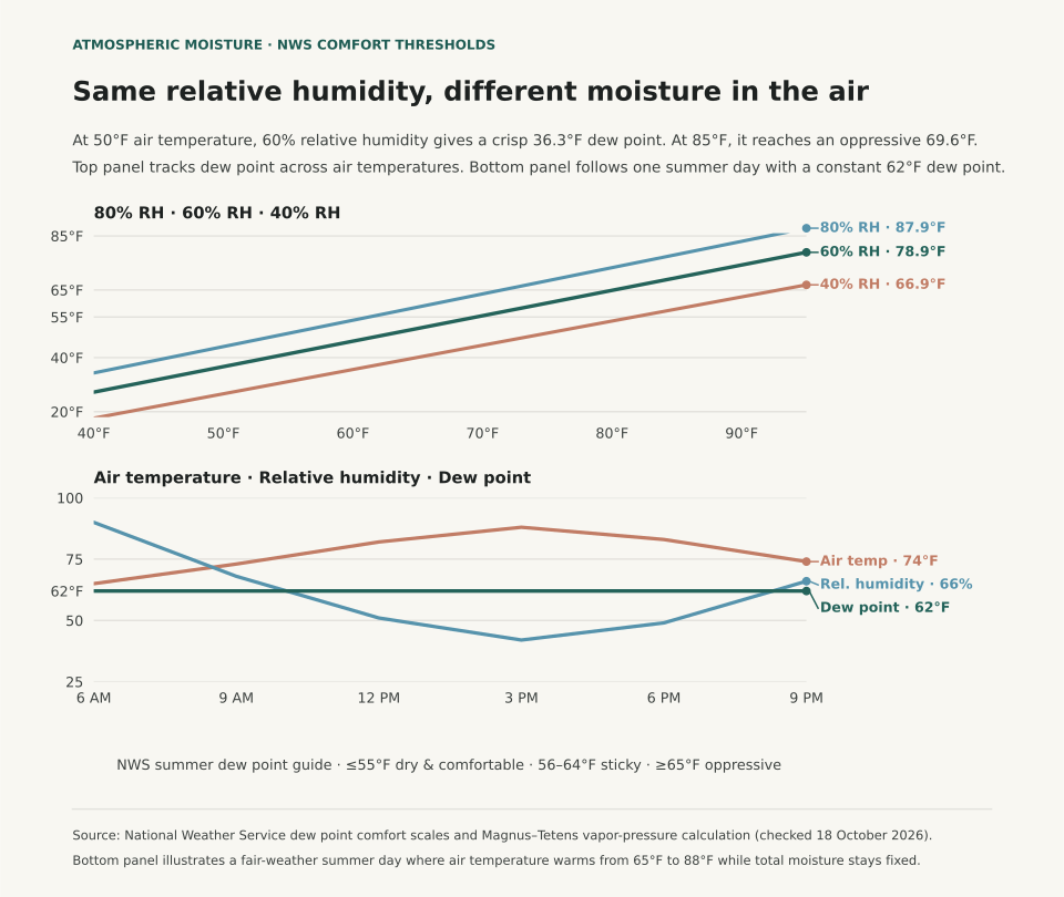
A 60% relative humidity reading feels crisp on a 50°F autumn morning because the dew point sits at 36.3°F, while that same 60% relative humidity feels sticky and oppressive on an 85°F summer afternoon because the dew point reaches 69.6°F. As the National Weather Service (NWS) explains, relative humidity measures how close the air is to saturation at its current temperature, whereas the dew point tracks the temperature at which the water vapor actually present in the air would condense into liquid.
When you check a weather forecast before a run, a commute, or an outdoor shoot, relative humidity alone can point you in the wrong direction. Because warm air can hold substantially more water vapor than cold air before reaching saturation, relative humidity falls every afternoon as the sun heats the ground and rises every night as the air cools—even when the total moisture in the air mass has not changed. Dew point removes that moving temperature denominator and gives you a direct scale for how muggy the air will feel against your skin.
Why Afternoon Relative Humidity Falls While Muggy Air Stays Put
The NWS Tampa Bay Weather Forecast Office defines the dew point as the temperature to which air must be cooled, at constant pressure, for water vapor to condense into dew, fog, or cloud droplets (100% relative humidity). Because the dew point cannot exceed the air temperature, a 30°F winter morning with a 30°F dew point has 100% relative humidity. By contrast, an 80°F summer afternoon with a 60°F dew point has 50% relative humidity. Even though the percentage is cut in half, the 80°F afternoon contains roughly three times as much water vapor and feels far more humid outside (NWS La Crosse).
Panel B in the figure above follows an illustrative summer day where no front or sea breeze replaces the air mass. At 6:00 AM, the air temperature is 65°F and the dew point is 62°F, producing 90% relative humidity. By 3:00 PM, solar heating pushes the air temperature to 88°F while the dew point remains 62°F. Relative humidity drops from 90% to 42% solely because 88°F air has a much higher moisture ceiling. Your body cools itself by evaporating perspiration from the skin, and the rate of evaporation depends on how much moisture is already in the air. Because that 62°F moisture load never left, sweat evaporates slowly and the afternoon feels warm and sticky despite the 42% relative humidity readout.
Reading the National Weather Service Dew Point Comfort Scale
Forecasters at NWS La Crosse and NWS Tampa Bay group summer dew points into three main comfort bands: 55°F or lower feels dry and comfortable, 56°F to 64°F feels noticeably sticky with muggy evenings, and 65°F or higher indicates heavy atmospheric moisture that feels oppressive. The table below pairs those thresholds with calculated dew points across air temperatures from 50°F to 90°F:
| Air Temp (°F) | Dew Point at 40% RH | Dew Point at 60% RH | Dew Point at 80% RH | Feel at 60% RH (NWS Summer Scale) |
|---|---|---|---|---|
| 50°F | 26.9°F | 36.3°F | 44.0°F | Dry and comfortable (≤55°F dew point) |
| 60°F | 35.9°F | 45.8°F | 53.8°F | Dry and comfortable (≤55°F dew point) |
| 70°F | 44.9°F | 55.3°F | 63.6°F | Threshold of sticky / muggy evenings (55–65°F) |
| 75°F | 49.4°F | 60.1°F | 68.5°F | Noticeably sticky; muggy in the evening (55–65°F) |
| 80°F | 53.9°F | 64.8°F | 73.4°F | Upper edge of sticky, approaching oppressive (65°F) |
| 85°F | 58.4°F | 69.6°F | 78.3°F | Oppressive moisture in the air (≥65°F dew point) |
| 90°F | 62.9°F | 74.3°F | 83.2°F | Heavily oppressive; high heat-stress risk (≥65°F) |
Where Relative Humidity Still Answers the Right Question
Dew point is the better number for human comfort outdoors, but relative humidity remains the right measure when the question is how fast moisture leaves wood, soil, or foliage at the current temperature. Fire-weather forecasters watch afternoon relative humidity fall below 20% to 30% because dead brush and forest fuels dry out in proportion to the vapor deficit at that hour's air temperature. The same physics explains why indoor air feels parched in January: when outdoor air with a 15°F dew point (and 80% outdoor relative humidity) is drawn inside and heated to 70°F without a humidifier, its relative humidity drops below 15%, pulling moisture from wood floors and skin.
When comparing seasonal climates across cities (see What Are Climate Normals? and Hottest Day on Record vs. Average Summer), looking at temperature and dew point together separates dry desert heat from Gulf Coast humidity. In NWS Tampa Bay's hourly station archive back to 1948, for example, Tampa recorded a peak dew point of 86°F on August 6, 2000, and experienced seven consecutive days with dew points at or above 75°F from August 5–11, 2024—conditions where nighttime lows cannot cool below the dew point.
Eranorms puts local weather observations into historical context across decades of station records, daily high-low timelines, and upper-air temperature and dewpoint soundings. Open Eranorms in your browser, Download Eranorms for iPhone, or Get Eranorms on Android.