
Graupel vs. Hail: How to Tell Soft Snow Pellets Apart from Ice
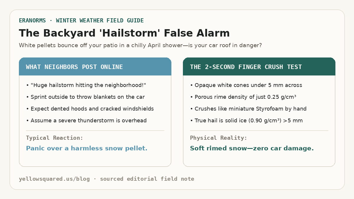
When small white ice pellets rattle against windows during a brisk spring or autumn rain shower, most people immediately call it hail. In reality, cold-season convective showers usually produce graupel—soft snow pellets that look like miniature hailstones at first glance but behave completely differently on impact. According to microphysical classifications from the NOAA National Severe Storms Laboratory (NSSL), you can tell graupel apart from hail in two seconds: pick up a pellet and pinch it. Graupel crumbles like miniature Styrofoam or packed powder, whereas a true hailstone is solid, translucent-to-layered ice that refuses to crush by hand.
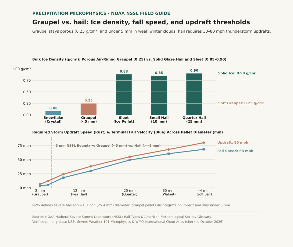
Understanding whether a storm is dropping graupel, sleet, or hail tells you what is happening thousands of feet overhead. Graupel forms in shallow, chilly clouds with modest updrafts around 10 miles per hour and never damages roofs, crops, or car paint. Hail requires violent thunderstorm updrafts between 30 and 80 miles per hour to suspend growing ice cores aloft until they reach destructive sizes.
Every true hailstone starts life as a tiny graupel pellet or frozen raindrop embryo, but without a thunderstorm updraft exceeding thirty miles per hour, graupel falls to Earth as harmless soft snow.
What Is Graupel and How Does It Form?
Graupel—officially cataloged as snow pellets (GS in aviation METAR observations)—starts as an ordinary six-sided snowflake high in a cold cloud. As that snowflake drifts downward through a layer of supercooled liquid cloud droplets (water droplets remaining liquid below 32°F / 0°C), the microscopic droplets freeze instantly onto the crystal's branches. Meteorologists call this process accretional riming.
Because each tiny droplet freezes almost instantaneously on contact, air pockets remain trapped between the frozen beads. As riming continues, the original six-pointed snow crystal disappears inside a bumpy, cone-shaped or spherical white jacket of frost. Trapped air keeps graupel's bulk density near 0.25 grams per cubic centimeter—roughly a quarter the density of solid glaze ice—and limits its terminal fall speed to around 2.2 meters per second (5 miles per hour). By international convention, graupel pellets measure less than 5 millimeters (0.2 inches) across.
How Hailstones Grow Inside Thunderstorm Updrafts
True hail (GR in METAR reports) only develops when a strong thunderstorm updraft captures a graupel embryo and lofts it repeatedly through a deep column of supercooled liquid water. In the NSSL hail growth model, a pellet must exceed 5 millimeters (0.2 inches) in diameter to be classified as hail, and a thunderstorm reaches official severe warning status when hailstones reach 1.0 inch (25.4 millimeters, roughly the size of a U.S. quarter).
As a hailstone cycles through different temperature zones inside a supercell updraft, it alternates between two distinct growth modes. In the colder upper cloud (well below 14°F / −10°C), supercooled droplets freeze immediately on impact, trapping microscopic air bubbles that form an opaque white ring (dry growth). In warmer, wetter cloud regions just below freezing, liquid water coats the stone and freezes slowly into clear, high-density solid ice near 0.90 grams per cubic centimeter (wet growth). Slicing a large hailstone in half reveals these alternating clear and cloudy rings like the growth rings of a tree.
A quarter-sized hailstone falls at nearly fifty miles per hour and requires a fifty-five-mile-per-hour storm updraft just to stay suspended in the cloud.
Graupel vs. Hail vs. Sleet: Quick Comparison Chart
Sleet (ice pellets) often joins the confusion during winter mix events, yet sleet forms without riming or thunderstorm updrafts. Sleet occurs when snowflakes melt completely into liquid raindrops while falling through an elevated warm layer, then refreeze into tiny, translucent hard ice beads inside a sub-freezing surface layer before hitting the ground.
| Precipitation Type | Diameter Range | Ice Density (g/cm³) | Fall Speed | Cloud Updraft Needed | Appearance & Finger Test |
|---|---|---|---|---|---|
| Snowflake (Unrimed) | 2 – 5 mm | 0.05 – 0.10 g/cm³ | 2 mph (1.0 m/s) | 1 – 3 mph | Flat six-branched crystal; melts on warm skin |
| Graupel (Snow Pellet) | 2 – 5 mm (<0.2 in) | 0.15 – 0.40 g/cm³ | 5 mph (2.2 m/s) | 5 – 15 mph | Opaque white cone or ball; crushes easily between fingers |
| Sleet (Ice Pellet) | 1.5 – 4 mm | 0.85 – 0.90 g/cm³ | 15 mph (6.5 m/s) | Stratiform warm nose | Clear translucent bead; bounces loudly and will not crush |
| Small Hail (Pea Size) | 5 – 12 mm (0.2–0.5 in) | 0.80 – 0.88 g/cm³ | 28 mph (12.5 m/s) | 25 – 35 mph | Hard ice core with mottled shell; resists finger pressure |
| Severe Hail (Quarter+) | 25 – 44+ mm (1.0–1.75 in) | 0.88 – 0.91 g/cm³ | 50 – 68 mph | 55 – 85+ mph | Concentric clear and white ice layers; dents metal and glass |
How to Tell Graupel from Hail on the Ground
When frozen pellets start falling, three quick checks settle the graupel-versus-hail question immediately:
- Pinch a pellet between your thumb and forefinger: If it flattens into powdery white granules or feels spongy, it is graupel. If it feels like a hard pebble from your freezer, it is sleet (if tiny and clear) or hail (if larger than a pencil eraser).
- Check the surface temperature and season: Graupel thrives in chilly 34°F–44°F (1°C–7°C) air when steep low-level lapse rates allow shallow cumulus clouds to rime snowflakes right down to the ground. Large hail thrives in warm, humid late-spring and summer air masses with high convective available potential energy (CAPE).
- Watch how it bounces: Graupel bounces once with a soft thud and collects in little white drifts resembling Dippin' Dots ice cream. Hail ricochets sharply off pavement and shatters only when hitting hard concrete at high terminal velocity.
Curious whether unstable spring and winter temperature swings are normal for your city? Open Eranorms in your browser or Download Eranorms for iPhone and Get Eranorms on Android to compare daily temperature anomalies and historical precipitation trends across decades of station records.