
What Causes Lake-Effect Snow? Why Cold Wind Over Warm Great Lakes Water Drops Feet of Snow in Narrow Bands
During a classic November or December lake-effect snowstorm in Buffalo, New York or on the Tug Hill Plateau east of Lake Ontario, radar displays a laser-straight snow plume just 5 to 15 miles wide dumping 5 inches (13 cm) of snow per hour accompanied by thunder and lightning—while drivers 10 miles north see blue sky and bare pavement. Unlike synoptic winter cyclones driven by thousand-mile low-pressure fronts, lake-effect snow is a localized convective heat engine powered by cold Arctic air streaming across relatively warm, unfrozen lake water. When National Weather Service (NWS) meteorologists forecast whether a cold front will produce harmless flurries or a multi-foot snow emergency, they check two physical numbers first: a 13°C (23°F) temperature drop between the lake surface and the 850 mb pressure level (~1,500 meters / 5,000 feet) and at least 75 km (50 miles) of open-water fetch.
Reader outcome: You will understand the exact adiabatic lapse rate math behind the 13°C (23°F) rule, why wind direction along Lake Erie's 240-mile long axis vs. Lake Michigan's 80-mile width changes band structure, and why lake-effect snow peaks in late autumn and shuts down once ice cover nears 70–100%.
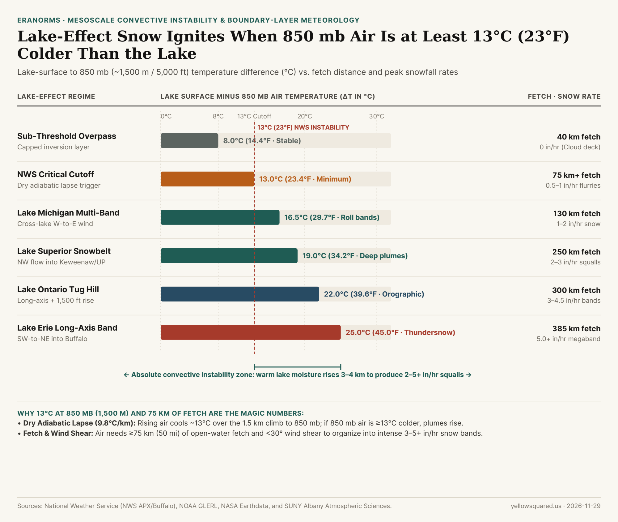
Why 13°C (23°F) Between the Lake and 850 mb Is the Magic Threshold
Why do atmospheric scientists specifically compare lake water temperature against the 850 millibar (85 kPa) pressure level rather than the surface thermometer on shore? In the lower troposphere, the 850 mb surface sits near 1,500 meters (~5,000 feet) altitude—just above the frictional planetary boundary layer where lake-effect cumulus towers form.
As a rising parcel of unsaturated air expands in lower pressure aloft, it cools at the dry adiabatic lapse rate of 9.8°C per kilometer (5.4°F per 1,000 feet). Over a vertical climb of roughly 1.3 to 1.5 kilometers from Great Lakes surface elevation (~175 m MSL) up to 850 mb (~1,500 m MSL), a dry parcel warmed to the lake water's temperature cools by approximately 13°C (23.4°F):
- When
ΔT < 13°C(Sub-Threshold / Stable): If the lake water is6°C(43°F) and the air at850 mbis-2°C(28°F, a8°Cdifference), a parcel of air warmed by the lake cools to-7°Cby the time it reaches1,500 m. Because-7°Cis colder and denser than the surrounding-2°Cair aloft, convection hits a brick wall and flattens into a shallow stratocumulus cloud deck. - When
ΔT ≥ 13°C(Absolute Instability): If Arctic air plunges850 mbtemperatures to-10°Cor-16°Cover a6°Clake (ΔT = 16°C to 22°C), the rising lake-warmed parcel remains warmer and more buoyant than the ambient atmosphere all the way through850 mband into the700 mblevel (~3,000 m / 10,000 ft). Latent heat released as water vapor condenses into cloud droplets slows cooling to the moist adiabatic lapse rate (~6°C/km), accelerating updrafts and generating thundersnow when ΔT exceeds 20°C–25°C.
A 13°C (23°F) drop between the lake surface and 850 mb (~5,000 feet) matches the dry adiabatic cooling of rising air—turning the lake into an uncapped vertical conveyor belt of heat and moisture.
How Fetch Distance and Wind Shear Shape Single Bands vs. Multi-Bands
Instability alone cannot produce a 4-foot snowstorm if the air spends only 15 minutes over water. As documented by mesoscale Great Lakes studies and NOAA's Great Lakes Environmental Research Laboratory (GLERL), an air mass needs a minimum over-water distance—called fetch—of at least 75 km (50 miles) along with weak directional wind shear (< 30° between the surface and 700 mb) to absorb enough heat and water vapor:
| Meteorological Regime / Basin | Surface-to-850mb ΔT (°C) | Surface-to-850mb ΔT (°F) | Over-Water Fetch | Directional Wind Shear | Typical Snowfall Rate & Band Morphology |
|---|---|---|---|---|---|
| Stable / Sub-Threshold Overpass | 8.0°C |
14.4°F |
40 km (25 mi) |
High (>60°) |
0.0 in/hr (Stratocumulus deck; no snow) |
| Marginal Instability Threshold | 13.0°C (Cutoff) |
23.4°F |
75 km (50 mi min) |
Moderate (30°–60°) |
0.5 to 1.0 in/hr (Light multi-band showers) |
| Lake Michigan Cross-Lake Multi-Bands | 16.5°C |
29.7°F |
130 km (80 mi W-to-E) |
Low (<30°) |
1.0 to 2.0 in/hr (Parallel roll bands in West MI) |
| Lake Superior Upper Peninsula Squalls | 19.0°C |
34.2°F |
250 km (155 mi NW-to-SE) |
Low (<25°) |
2.0 to 3.0 in/hr (Deep convective snow belts) |
| Lake Ontario Tug Hill Single Plume | 22.0°C |
39.6°F |
300 km (185 mi W-to-E) |
Very Low (<15°) |
3.0 to 4.5 in/hr (Orographic lift + thundersnow) |
| Lake Erie Long-Axis Buffalo Megaband | 25.0°C |
45.0°F |
385 km (240 mi SW-to-NE) |
Aligned (<10°) |
5.0+ in/hr (Extreme single band with lightning) |
Why Lake Erie Freezes Shut Earliest While Lake Ontario Snow Runs All Winter
Beyond instability and fetch, two physical terrain controls explain why eastern Great Lakes snowbelts outproduce western ones. First is land-breeze convergence and frictional drag: when wind blows parallel to the 240-mile (385-km) southwest-to-northeast long axis of Lake Erie, cooler air draining off both the Canadian and U.S. shorelines converges down the center of the warm lake, focusing all upward motion into a single stationary firehose pointed straight at the Buffalo metro area. When that plume hits shore, rough land surface friction slows the wind by 30% to 50%, causing air to pile up (speed convergence) and rise even faster—augmented east of Lake Ontario by the 1,500-foot topographic rise of the Tug Hill Plateau.
Second is bathymetry and thermal inertia. Because Lake Erie is the shallowest of the Great Lakes (averaging just 19 meters / 62 feet deep), its peak lake-effect season fires fiercely in November and December while water temperatures sit at 45°F to 52°F, then abruptly shuts down in mid-to-late winter once surface ice cover seals off heat and moisture fluxes. Deeper basins like Lake Ontario (average depth 86 m / 283 ft) and Lake Michigan (85 m / 279 ft) rarely freeze across their central cores, sustaining snow squalls from November through March. To track daily station snowfall and temperature anomalies against 30-year NOAA baselines across Great Lakes ASOS stations, Compare station weather against climate normals in Eranorms.