
What Is a Bomb Cyclone? Explosive Cyclogenesis Explained
What Is a Bomb Cyclone? Explosive Cyclogenesis Explained
A mid-latitude storm becomes a bomb cyclone when its central atmospheric pressure drops by at least 24 millibars in 24 hours—triggering hurricane-force gusts, coastal storm surges, and rapid barometric plunges.
When powerful winter storms sweep along the North American coastline, meteorologists frequently describe them as "bomb cyclones" or warn of impending "bombogenesis." To the general public, the terminology sounds sensationalized—like an exaggerated modern headline designed for social media engagement. In atmospheric physics, however, a bomb cyclone is a precisely defined mathematical classification that has guided storm forecasting for nearly half a century.
Coined in a landmark 1980 paper by MIT meteorologists Fred Sanders and John Gyakum, explosive cyclogenesis describes an extratropical low-pressure system whose barometric pressure drops with astonishing rapidity. When atmospheric column weight collapses this quickly, the surrounding atmosphere rushes inward to fill the void, generating destructive hurricane-force wind gusts, catastrophic coastal flooding, and violent snowfall rates.
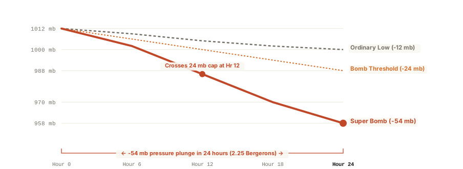
The Bergeron Rate: Defining Explosive Deepening
In mid-latitude meteorology, an extratropical cyclone is classified as a bomb when its central sea-level pressure deepens by at least 24 millibars (hPa) over a 24-hour period. Because planetary vorticity varies with latitude, Sanders and Gyakum established a normalized metric known as the Bergeron, named in honor of Swedish meteorology pioneer Tor Bergeron:
One Bergeron represents a central pressure fall of 24 millibars in 24 hours normalized to 60 degrees latitude: B = (ΔP / 24) × (sin 60° / sin φ).
At 60° North (near Anchorage or Oslo), a storm requires the standard 24 mb drop in 24 hours to equal 1.0 Bergeron. At 40° North (near New York City or Madrid), the planetary spin is weaker, requiring an 17.8 mb drop in 24 hours to qualify as explosive cyclogenesis. Modern super-bombs frequently exceed 2.0 Bergerons, dropping 40 to 55+ millibars in a single day as they encounter warm Gulf Stream or Kuroshio ocean currents.
Atmospheric Dynamics: How the Jet Stream Fuels the Plunge
Unlike tropical hurricanes, which extract thermal energy entirely from warm ocean waters through latent heat release, bomb cyclones derive their power from baroclinic instability—the collision of radically different air masses.
- Vigorous Jet Streak Divergence: Bomb cyclones occur when a potent upper-level disturbance encounters the left-exit region of a 160+ knot jet stream. High aloft, air diverges rapidly, creating a powerful vacuum that evacuates air molecules from the column faster than low-level winds can converge to replenish them.
- Extreme Thermal Contrasts: As freezing continental Arctic air spills off the eastern seaboard and clashes with the warm, moisture-rich Gulf Stream, temperature gradients exceeding 35°F across 100 miles supercharge baroclinic energy conversion.
- Sensory Impact on Barometers: During a bomb cyclone, home aneroid barometers and smartphone pressure sensors show continuous, steep declines, often plunging 2 to 3 millibars per hour—a rate that frequently triggers ear-popping sensations among coastal residents.
Understanding barometric deepening rates helps emergency planners anticipate sudden coastal surges and structural wind hazards hours before precipitation begins. You can Analyze atmospheric soundings on Eranorms to inspect thermodynamic profiles and jet stream wind structures during major winter storms.