
What Is a Chinook Wind, and How Did Loma, Montana Warm 103 Degrees in 24 Hours?
Between 9:00 AM on January 14 and 8:00 AM on January 15, 1972, the official weather station in Loma, Montana recorded the largest 24-hour temperature change ever measured on Earth: the air temperature rocketed by 103°F (57.2°C), climbing from a bone-chilling −54°F (−47.8°C) to +49°F (+9.4°C) (Chinook wind - Wikipedia; United States temperature extremes - Wikipedia). Even faster, on the morning of January 22, 1943, in Spearfish, South Dakota, a roaring westerly gust raised the temperature by 49°F (27.2°C) in just two minutes—jumping from −4°F (−20.0°C) at 7:30 AM to +45°F (+7.2°C) at 7:32 AM and cracking frosted plate-glass windows across town (Chinook wind - Wikipedia).
Both meteorological extremes were driven by a Chinook wind—the North American name for a warm, dry downslope Foehn wind descending the leeward side of a mountain barrier (Foehn wind - Wikipedia). To see how sudden winter downslope warming spikes compare against 30-year seasonal station baselines, Compare live station extremes against historical climate normals in Eranorms.
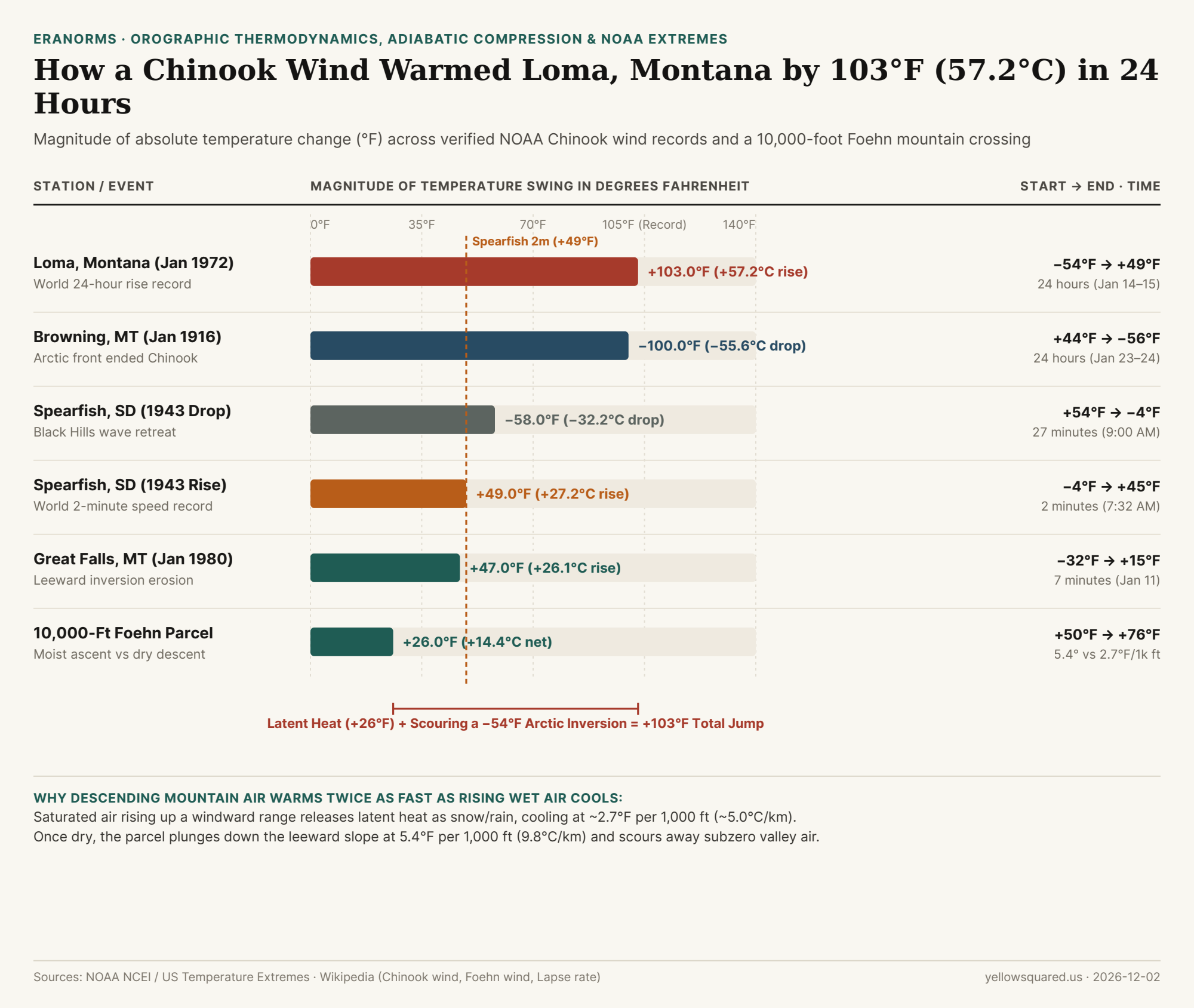
Mechanism 1: Moist vs. Dry Adiabatic Lapse Rates (+26°F Across 10,000 Feet)
Why does air arrive at the bottom of the eastern Rocky Mountains dramatically warmer than when it started at the exact same elevation on the western windward slope? The classical thermodynamic mechanism comes from the asymmetry between the moist adiabatic lapse rate (MALR) and the dry adiabatic lapse rate (DALR) (Lapse rate - Wikipedia; Foehn wind - Wikipedia):
- Windward Ascent at the Moist Adiabatic Rate (~2.7°F / 1,000 ft or 5.0°C / km): Once a rising maritime air parcel cools to its dew point (the lifting condensation level), water vapor condenses into clouds, rain, and snow. Condensing 1 gram of water vapor releases 2,500 joules of latent heat into the air parcel, slowing its cooling rate to roughly
2.7°F per 1,000 feet(~5.0°C/km) (Lapse rate - Wikipedia). - Leeward Descent at the Dry Adiabatic Rate (5.4°F / 1,000 ft or 9.8°C / km): After precipitating its moisture onto the windward peaks, the now-dry air parcel plunges down the leeward eastern slope. Rising atmospheric pressure compresses the parcel, warming it at the full dry adiabatic rate of 5.4°F per 1,000 feet (9.8°C/km)—nearly twice the rate at which it cooled on the way up (Lapse rate - Wikipedia).
- Net Parcel Gain Across a 10,000-Foot (3,000 m) Barrier: An air parcel starting at
+50°F (+10.0°C)that rises 10,000 feet saturated (−27°Fto+23°Fat the crest) and descends 10,000 feet dry (+54°Fof compressional warming) reaches the leeward plains at +76°F (+24.4°C)—a net thermodynamic gain of +26°F (+14.4°C).
"Latent heat adds 20°F to 30°F as air crosses a mountain range, but a 103°F Chinook surge happens when that downslope jet scours away a shallow −50°F Arctic air mass pooled on the plains."
Mechanism 2: Isentropic Drawdown & Arctic Inversion Scouring
If latent heat release over a mountain range adds 20°F to 30°F, how did Loma, Montana warm by 103°F? Modern mesoscale meteorology shows that extreme winter Chinooks combine mechanical isentropic drawdown with Arctic air-mass displacement (Foehn wind - Wikipedia; Chinook wind - Wikipedia):
- Shallow Subzero Continental Polar Pools: Before a winter Chinook strikes the High Plains of Montana, Alberta, or South Dakota, a dense, shallow layer of radiatively cooled Arctic air (often only 300 to 600 meters deep) sits trapped against the eastern foothills at
−30°F to −54°F. - Mountain Wave Scouring & Hydraulic Jumps: When strong westerly winds blow across the Rockies or Black Hills, high-potential-temperature air from near crest level is forced violently down the leeward slope. As this turbulent downslope jet flushes the shallow Arctic pool eastward, surface thermometers transition in minutes from a radiative subzero inversion into the adiabatically compressed Pacific air mass (Chinook wind - Wikipedia).
- Sloshing Leeward Boundaries (Spearfish 1943 & Browning 1916): Because the boundary between the warm Chinook jet and the dense Arctic air mass is razor-sharp, when the mountain wave weakens or retreats, the subzero air sloshes back just as fast. In Spearfish on January 22, 1943, after warming
+49°Fin 2 minutes at 7:32 AM and peaking at+54°F, the Chinook retreated at 9:00 AM and the temperature plunged −58°F (from +54°F back to −4°F) in 27 minutes (Chinook wind - Wikipedia).
| Station / Thermodynamic Event | Date or Step | Start Temp | End Temp | Net Swing | Duration & Mechanism |
|---|---|---|---|---|---|
| 1. Loma, Montana (World Record) | Jan 14–15, 1972 | −54.0°F (−47.8°C) |
+49.0°F (+9.4°C) |
+103.0°F (+57.2°C) | 24 hours · World 24h record |
| 2. Browning, Montana (Drop) | Jan 23–24, 1916 | +44.0°F (+6.7°C) |
−56.0°F (−48.9°C) |
−100.0°F (−55.6°C) | 24 hours · Arctic front return |
| 3. Spearfish, SD (Morning Drop) | Jan 22, 1943 | +54.0°F (+12.2°C) |
−4.0°F (−20.0°C) |
−58.0°F (−32.2°C) | 27 minutes · Wave retreat |
| 4. Spearfish, SD (2-Min Rise) | Jan 22, 1943 | −4.0°F (−20.0°C) |
+45.0°F (+7.2°C) |
+49.0°F (+27.2°C) | 2 minutes · Fastest rise |
| 5. Great Falls, Montana | Jan 11, 1980 | −32.0°F (−35.6°C) |
+15.0°F (−9.4°C) |
+47.0°F (+26.1°C) | 7 minutes · Inversion eroded |
| 6. 10,000-Ft Foehn Parcel | 0 → 3,000m → 0m | +50.0°F (+10.0°C) |
+76.0°F (+24.4°C) |
+26.0°F (+14.4°C) |
Moist (2.7°F) vs dry (5.4°F/1k ft) |
Why Chinooks Are Called "Snow Eaters" Along the Front Range
Because adiabatically compressed Chinook air arrives at the base of the mountains with relative humidity often below 10% to 15% and wind gusts exceeding 50 to 80 mph, it simultaneously melts and sublimates a foot of snowpack in hours—earning the Indigenous and fur-trade moniker "Snow Eater" (Chinook wind - Wikipedia). Look up toward the crest during a Chinook and you will frequently spot the signature Chinook arch: a stationary band of altocumulus standing lenticular clouds riding the crest of the leeward atmospheric gravity wave while clear blue sky opens directly over the mountains. To track live temperature, dew point, and pressure swings against historical ASOS station records, Compare live station extremes against historical climate normals in Eranorms.