
What Is a Heat Dome? How It Traps Extreme Heat
A heat dome is not simply hot southern air blowing north; it is a persistent, upper-tropospheric high-pressure ridge (an omega block) that acts like a pressure cooker lid, forcing sinking air to compress and heat adiabatically while cloudless skies bake parched ground below. Sinking subsidence air warms at the dry adiabatic lapse rate of roughly 9.8°C per kilometer, creating a dense inversion cap at 850 hPa that traps surface heat, pollutants, and humidity for weeks.
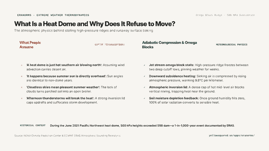
When extreme heat waves break all-time records by 5°C to 10°C—such as the catastrophic June 2021 Pacific Northwest heat dome that drove Portland to 116°F (46.7°C) and Lytton, British Columbia to an unprecedented 121°F (49.6°C)—the responsible meteorological engine is almost always an amplified 500 hPa anticyclone. Atmospheric reanalysis datasets from the European Centre for Medium-Range Weather Forecasts (ECMWF) show that these events push mid-tropospheric heights past 598 decameters (dam), a statistical 1-in-1,000-year recurrence value.
A heat dome is fueled from the top down; the atmosphere compresses itself, turning sinking air into a furnace before it ever touches the earth.
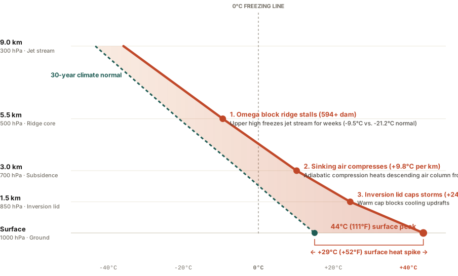
The 4-Stage Engine: How Heat Domes Form and Persist
Meteorologists identify four interconnected physical mechanisms that lock a heat dome in place:
- The Jet Stream Omega Block: A high-amplitude Rossby wave bends the polar jet stream into a shape resembling the Greek letter Ω (omega). The central ridge of high pressure stalls between two flanking cutoff low-pressure systems, freezing the weather pattern in place for 7 to 21 days.
- Subsidence and Adiabatic Compression: High in the troposphere (300 to 500 hPa), converging winds force dense air downward. As this air sinks into higher atmospheric pressure near the surface, it compresses rapidly. This compression heats the air without any external heat source at the dry adiabatic lapse rate of ~9.8°C per 1,000 meters of descent.
- The 850 hPa Inversion Lid: This sinking layer creates a pronounced temperature inversion between 1.0 km and 2.5 km altitude. Warm air sits above cooler boundary air, forming an impenetrable cap that prevents vertical convection. Potential storm clouds are suffocated before they can build, blocking any rain from cooling the surface.
- Soil Moisture Depletion Feedback: Under cloudless skies, intense solar radiation bakes the topsoil. Once soil moisture evaporates completely, latent heat cooling drops to zero. 100% of incoming solar energy converts directly into sensible surface heat, driving ground temperatures past 120°F (49°C).
Sounding Comparison: Normal Summer vs. Heat Dome
| Altitude Level | Typical Summer Temp | Heat Dome Temp | Thermal Anomaly | Role in Heat Dome |
|---|---|---|---|---|
| 300 hPa (9.0 km) | -43.5°C (-46°F) | -36.0°C (-33°F) | +7.5°C | Omega ridge stalls jet stream westerlies |
| 500 hPa (5.5 km) | -21.2°C (-6°F) | -9.5°C (+15°F) | +11.7°C | Geopotential height peak (>594 dam) |
| 700 hPa (3.0 km) | -4.6°C (+24°F) | +10.2°C (+50°F) | +14.8°C | Strongest adiabatic compression heating |
| 850 hPa (1.5 km) | +5.0°C (+41°F) | +24.5°C (+76°F) | +19.5°C | Inversion cap suffocates thunderstorm updrafts |
| Surface (0.0 km) | +15.0°C (+59°F) | +44.0°C (111°F) | +29.0°C Departure | Dry soil sensible heat spike |
How to Survive a Stalled Heat Dome Event
- Nighttime temperatures are the primary health hazard: In a heat dome, sinking air traps surface heat overnight, keeping minimum temperatures above 80°F (27°C); without nighttime physiological relief, cardiovascular stress multiplies.
- Hydrate before outdoor exposure: High vapor pressure deficits evaporate sweat almost instantly, leading to rapid dehydration before thirst cues trigger.
- Track local historical climate anomalies: Compare current temperature departures against 30-year station normals and weather soundings with Eranorms.