
What Is Virga, and Why Does Evaporating Rain Trigger Dangerous Dry Microburst Winds?
Across the American Southwest, the High Plains, and interior Australia, summer afternoon clouds frequently trail wispy, comma-shaped curtains of precipitation that vanish in mid-air thousands of feet above the ground. In atmospheric science (as defined in the NOAA National Weather Service Glossary of Convective Storms and Glossary of Meteorology), these evaporating precipitation shafts are called virga. While a vanishing rain shower looks harmless from a distance, the phase change happening inside that virga shaft can trigger one of aviation and desert meteorology's most hazardous phenomena: a dry microburst capable of producing straight-line surface winds of 25 to 58 m/s (56 to 130 mph) without a single drop of rain reaching the ground.
Why does disappearing rain generate destructive wind gusts? As documented in convective research on dry downbursts and negative buoyancy and thermodynamic constants in the Scio.ly Meteorology Study Guide, evaporating water and sublimating ice extract massive quantities of latent heat directly from the mid-tropospheric air column. Compare seasonal humidity, temperature, and precipitation normals in Eranorms to see where high afternoon temperatures and low afternoon dew points create prime dry-microburst climatologies.
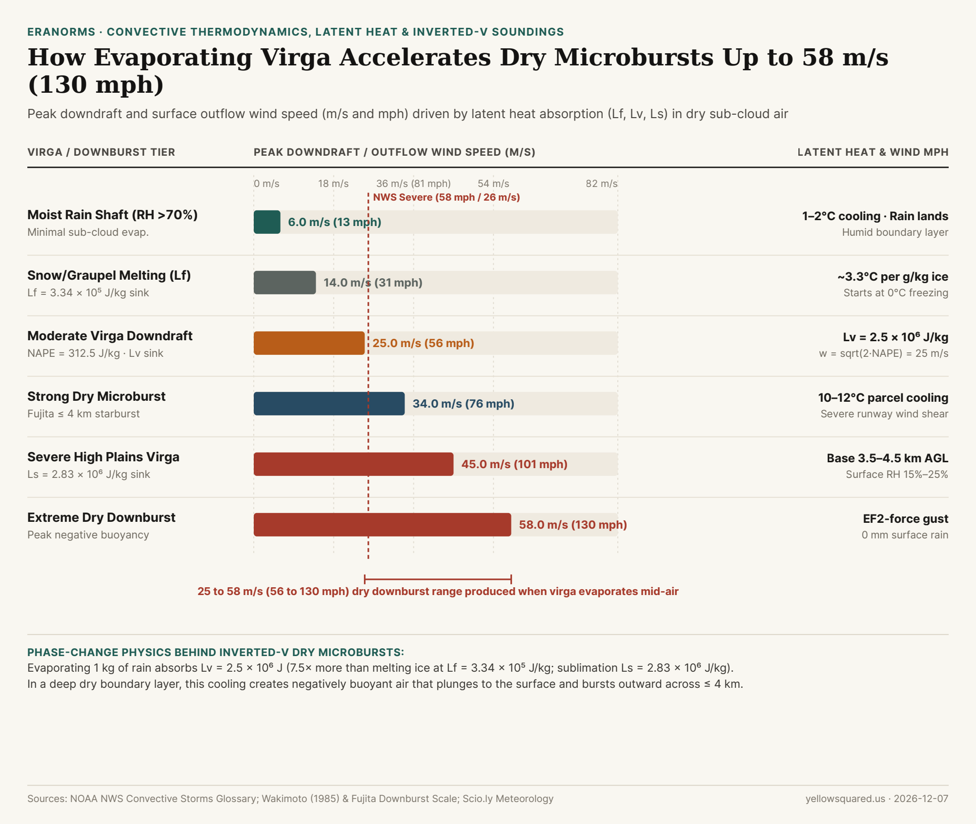
m/s and mph) across six convective regimes, illustrating how latent heat of fusion (L_f), vaporization (L_v), and sublimation (L_s) drive dry microbursts. Sources: Downburst Thermodynamics, Scio.ly Meteorology Constants, and NOAA NWS Glossary · Download CSV dataset.The Thermodynamics of Phase Change: L_f, L_v, and L_s
When precipitation falls from a high-based cumulus or cumulonimbus cloud (typically 3,000 to 4,500 meters / 10,000 to 15,000 feet above ground level) into a deep, dry, well-mixed sub-cloud layer (surface relative humidity 15%–25%), the energy required to turn ice and liquid water into water vapor is drawn directly from the sensible heat of the surrounding air parcel:
- Latent Heat of Fusion (
L_f = 3.34 × 10⁵ J/kg): As snow and graupel descend below the freezing level (0°C), melting absorbs334,000 joulesper kilogram of ice. Because dry air has a specific heat at constant pressure ofc_p = 1,005 J/(kg·°C), melting just1 gof ice per kilogram of dry air cools the air parcel by roughly0.33°C. - Latent Heat of Vaporization (
L_v ≈ 2.50 × 10⁶ J/kg): As liquid raindrops evaporate into dry sub-cloud air, every kilogram of water absorbs 2.5 million joules—roughly 7.5 times more thermal energy than melting ice. Evaporating3 gof rain per kilogram of dry air chills the parcel by~7.5°C. - Latent Heat of Sublimation (
L_s ≈ 2.83 × 10⁶ J/kg): When ice crystals sublimate directly into vapor in bone-dry mid-level air, the combined energy sink reaches 2.83 million joules per kilogram.
"In a classic 'inverted-V' sounding, the sub-cloud layer follows a steep dry-adiabatic lapse rate (9.8°C/km). As virga evaporates into that layer, the chilled air parcel stays colder and denser than its surroundings all the way to the ground—accelerating downward like an invisible waterfall of cold air."
From Negative Buoyancy (NAPE) to 130 mph Starburst Winds
In vertical momentum physics, the downward acceleration of an evaporatively cooled air parcel is governed by its Negative Available Potential Energy (NAPE)—the vertically integrated negative buoyancy from the cloud base to the ground:
w_max = sqrt(2 × NAPE)
As shown in downburst buoyancy derivations, even a moderate negative buoyant energy of NAPE = 312.5 m²/s² (J/kg) accelerates a descending column to w_max = sqrt(2 × 312.5) = 25.0 m/s (56 mph / 90 km/h). When that dense cold column hits the ground, it cannot penetrate the surface; instead, it splashes radially outward in all directions across a localized starburst footprint defined by storm researcher Ted Fujita as <= 4 km (2.5 miles) in diameter for a microburst (and > 4 km for a macroburst).
Reproducible Virga & Dry Microburst Regimes Table
The table below compares the latent heat mechanism, sub-cloud parcel cooling, and resulting downdraft/outflow wind speeds across six convective profiles (download the raw CSV dataset):
| Convective / Virga Regime | Dominant Phase-Change Sink | Sub-Cloud Parcel Cooling | Peak Wind (m/s) |
Peak Wind (mph) |
Surface Signature & Aviation Hazard |
|---|---|---|---|---|---|
| Moist Synoptic Rain Shaft | RH > 70% (Minimal evaporation) |
1°C to 2°C |
6.0 m/s |
13 mph | Steady rain reaches surface; benign wind shift |
| Snow & Graupel Melting Layer | L_f = 3.34 × 10⁵ J/kg |
~3.3°C per 10 g/kg ice |
14.0 m/s |
31 mph | Initiates negative buoyancy at the 0°C melting level |
| Moderate Virga Downdraft | L_v = 2.50 × 10⁶ J/kg (NAPE = 312.5) |
6°C to 8°C |
25.0 m/s |
56 mph | Rain vanishes aloft; blowing dust ring at surface |
Strong Dry Microburst (<= 4 km) |
Combined L_f + L_v sink |
10°C to 12°C |
34.0 m/s |
76 mph | Exceeds NWS severe thunderstorm wind threshold (58 mph) |
| Severe High Plains Virga | L_s = 2.83 × 10⁶ J/kg sublimation |
12°C to 15°C |
45.0 m/s |
101 mph | High base (3.5–4.5 km) over 15%–25% RH boundary layer |
| Extreme Straight-Line Downburst | Maximum sub-cloud collapse | > 15°C density drop |
58.0 m/s |
130 mph | EF2-equivalent wind damage with 0 mm surface rainfall |
How to Spot a Dry Microburst on the Trail or Runway
Because dry microbursts contain no heavy rain core to show up brightly on standard weather radar reflectivity, your best visual warning is the combination of wispy virga shafts overhead and an expanding ring of blowing dust (a curl or rotor cloud) along the ground. Whenever afternoon temperatures exceed your dew point by more than 25°C (45°F) under high-based convective clouds, secure tents, canopies, and light aircraft long before the virga passes overhead. Compare seasonal humidity, temperature, and precipitation normals in Eranorms to inspect historical afternoon dew-point spreads and dry-season wind risks for any destination.