
What Is Virga? Why Rain Evaporates Before Reaching the Ground
What Is Virga? Why Rain Evaporates Before Reaching the Ground
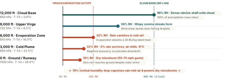
Virga forms when precipitation falls out of a high cloud base (600–700 hPa) into an arid sub-cloud boundary layer—vaporizing in mid-air while absorbing 2.26 MJ/kg of latent heat that can accelerate dangerous 60-mph dry microburst downdrafts.
Step outside on an arid afternoon in Denver, Phoenix, or Salt Lake City, look toward a darkening deck of mid-level clouds, and you will often spot dramatic, jellyfish-like curtains of rain or snow trailing downward from the cloud base—only to taper into feathery wisps and vanish thousands of feet above the ground. Check your phone's weather radar at the exact same moment, and the map may show a bright green blob of precipitation directly over your neighborhood while the sidewalk beneath your shoes remains bone-dry.
Meteorologists call these evaporating precipitation shafts virga (from the Latin word for a rod, twig, or streak). While virga often looks peaceful from a distance—especially at sunset when low-angle light turns the hanging ice crystals crimson and gold—the thermodynamic process happening inside that vanishing rain shaft is one of the primary engines of severe low-altitude wind shear.
The Physics: Inverted-V Soundings and Why Virga Bends Like a Comma
Virga requires a two-layer atmospheric sandwich: a moist, saturated mid-tropospheric cloud deck aloft (`500 to 700 hPa`, or roughly 10,000 to 16,000 feet above ground) sitting atop a deep, arid sub-cloud boundary layer where the dew-point depression (`T - Td`) exceeds 15°C to 25°C (`27°F to 45°F`). On a skew-T log-P thermodynamic diagram, this setup traces a classic "Inverted-V" sounding profile because the temperature line and dew-point line spread wide apart near the ground and pinch together into an upside-down V at the cloud base.
Why do virga streaks curve into graceful comma hooks instead of hanging straight down? As raindrops or snow crystals fall into dry air and shrink by evaporation, their terminal fall velocity drops dramatically (a `2 mm` raindrop falls at `6.5 m/s`, whereas a shrunken `0.2 mm` droplet drifts downward at less than `0.7 m/s`). Because horizontal wind speed usually changes with altitude, those slow-drifting micro-droplets near the bottom tip of the virga trail get blown sideways by wind shear, curving the shaft into a comma tail before it vaporizes completely.
Evaporation does not destroy energy; every gram of rain that vanishes in mid-air extracts 2,260 joules of heat from the surrounding air, turning a warm breeze into a plunging cold downdraft.
How Virga Triggers 65-MPH "Dry Microbursts" and Phantom Radar Echoes
Two practical hazards accompany strong virga events:
- Dry Microburst Wind Shear: Phase changes require massive amounts of thermal energy. Evaporating liquid water absorbs 2.26 megajoules per kilogram (`2,260 J/g`) of latent heat (and sublimating ice crystals absorb even more: 2.83 MJ/kg). That rapid cooling chills the air parcel inside the virga shaft by `5°C to 10°C` relative to the warm ambient air outside. Because cold air is denser than warm air, the chilled parcel plunges toward the ground like a dropped bowling ball—hitting the surface and fanning out radially as a 50-to-75 mph dry microburst even when zero rain reaches the ground.
- Phantom Radar Echoes: Weather radar beams angle upward at `0.5°` to `1.5°` as they travel away from the radar dome. At 50 miles from the radar station, the beam scans the atmosphere at 4,000 to 8,000 feet above the ground—detecting the dense precipitation inside the upper virga shaft long before it evaporates in the dry air below.
To inspect live Inverted-V sub-cloud dew-point depressions and downdraft convective available potential energy (`DCAPE`), you can Analyze atmospheric soundings on Eranorms for any upper-air station or forecast grid.