
Why Are Flights Faster Flying East Than West? How the Jet Stream Shaves Hours Off Travel
Look up any non-stop winter flight schedule between New York (JFK) and London Heathrow (LHR), or between Tokyo (HND) and Los Angeles (LAX), and you will see a striking asymmetry: flying east from New York to London is scheduled for roughly 6 hours and 50 minutes (and frequently lands in 5 hours and 15 minutes of air time), whereas flying the exact same aircraft west from London back to New York takes 8 hours to 8 hours and 25 minutes. On transpacific routes, an eastbound Tokyo-to-Los Angeles flight takes roughly 9 hours and 45 minutes, while the westbound return takes 11 hours and 50 minutes.
Why is flying east consistently 1.5 to 2.5 hours faster than flying west? A widespread myth claims that planes flying west are flying against the rotation of the Earth while planes flying east let the Earth spin toward them—which is physically backwards (and would violate conservation of momentum). The real driver is the Polar and Subtropical Jet Streams: narrow, meandering rivers of 135 to 260 mph west-to-east wind positioned at the exact 30,000-to-39,000-foot tropopause where modern jetliners cruise. Here is the atmospheric physics behind why jet streams only blow from west to east, why they peak in winter, and how airline dispatchers redraw oceanic highways twice a day to ride or dodge them.
1. Debunking the “Spinning Earth” Myth—and How Thermal Wind Creates the Jet Stream
First, let's clear up the common misconception about Earth's rotation. At the equator, the Earth's surface rotates from west to east at 1,037 mph (1,670 km/h), and at 40°N latitude (New York / Madrid) at roughly 795 mph. First, if the Earth rotated independently beneath a stationary atmosphere, flying west would actually be super-fast because your destination would be spinning toward you at 800 mph! Second, the atmosphere is dragged along with the planet by friction and gravity, and an airplane sitting on the runway in New York already possesses that exact 795 mph eastward rotational momentum before takeoff.
Why, then, does the upper atmosphere flow faster from west to east than the ground below it? As explained in meteorological analyses of the jet stream and aviation navigation guides, the jet stream is a geostrophic thermal wind born from two forces working together:
- The Equator-to-Pole Temperature Gradient (Hypsometric Pressure Slope): Warm tropical air is less dense and expands vertically to a high tropopause (~55,000 ft), whereas frigid polar air is dense and contracts to a low tropopause (~25,000–30,000 ft). At 35,000 feet above sea level, there is substantially more atmospheric mass (higher pressure) stacked above the tropics than above the poles, creating a steep upper-air pressure gradient pushing air from the equator toward the poles.
- Coriolis Deflection and Angular Momentum Conservation: As parcels of upper-tropospheric air move poleward from the equator toward higher latitudes, their distance from Earth's rotational axis shrinks (conservation of angular momentum speeds up their eastward velocity) and the Coriolis effect deflects moving air to the right in the Northern Hemisphere and to the left in the Southern Hemisphere—turning poleward flow into a concentrated west-to-east (westerly) river of wind in both hemispheres.
“Both the Northern Hemisphere and Southern Hemisphere jet streams blow from west to east: temperature gradients push upper-level air toward the poles, and Earth's Coriolis deflection turns that poleward flow into an eastward-racing ribbon at the tropopause.”
2. Polar Jet vs. Subtropical Jet—and Why Winter Flights Break Speed Records
Each hemisphere features two primary jet streams sitting at breaks in the tropopause. As detailed in Boldmethod's North Atlantic flight weather analysis, their altitude and seasonal behavior directly govern airline schedules:
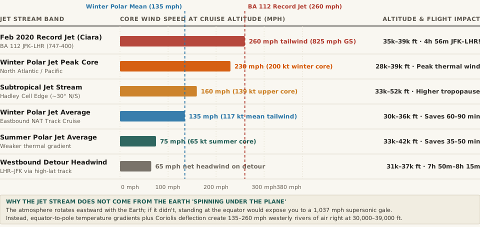
| Atmospheric Wind Band or Scenario | Typical Altitude Band (ft / km MSL) | Core Wind Speed (mph / knots) | Eastbound vs. Westbound Impact | Physical Mechanism & Aviation Routing |
|---|---|---|---|---|
| BA Flight 112 Record (Feb 2020) | 35,000–39,000 ft (Storm Ciara) | 260 mph tailwind (825 mph GS) | 4h 56m JFK–LHR (80m early) | Boeing 747-400 rode a 260 mph Polar Jet core to set the subsonic transatlantic record |
| Winter North Atlantic Polar Jet Peak | 28,000–39,000 ft (8.5–11.9 km) | 230 mph (200 kt core) | +150 to +230 mph eastbound boost | Driven by extreme winter temperature contrast between Arctic air and warm Gulf Stream |
| Subtropical Jet Stream (30° N/S) | 33,000–52,000 ft (10.0–15.8 km) | 160 mph (139 kt mean peak) | High-altitude westerly boost near 30° | Driven by angular momentum conservation at the poleward boundary of the Hadley cell |
| Typical Winter Polar Jet Cruise | 30,000–36,000 ft (9.1–11.0 km) | 135 mph (117 kt average) | Saves 60–90 min on NYC–London | Eastbound North Atlantic Tracks (NAT) are plotted directly inside the maximum core |
| Summer Mid-Latitude Polar Jet | 33,000–42,000 ft (10.0–12.8 km) | 75 mph (65 kt summer core) | Smaller 35–50 min schedule gap | Summer Arctic warming weakens the equator-to-pole temperature differential |
| Westbound Detour Penalty (LHR–JFK) | 31,000–37,000 ft (Northern detour) | 65 mph net headwind | 7h 50m to 8h 15m westbound time | Westbound flights detour hundreds of miles north/south to dodge the 200 mph core |
Why Winter Produces 800+ mph Subsonic Ground Speeds
Why is the North Atlantic jet stream nearly twice as fast in January and February as in July? During the Northern Hemisphere winter, the sun does not rise above the Arctic Circle, plunging polar air temperatures below −40 °C while the tropical Atlantic stays warm. Because the thermal wind speed is directly proportional to the horizontal temperature gradient (ΔT / Δy), the winter Polar Jet Stream intensifies to 135–230+ mph right between 28,000 and 39,000 feet MSL—the exact cruise ceiling of every Boeing 777, 787, and Airbus A350.
Remember the fundamental aviation equation:
Ground Speed (GS) = True Airspeed (TAS) + Tailwind Component (− Headwind Component)
On the night of February 8–9, 2020, as extratropical cyclone Storm Ciara supercharged the North Atlantic Polar Jet to 260 mph (226 knots), British Airways Flight 112 (a Boeing 747-400 cruising at Mach 0.85, ~565 mph true airspeed) rode the core from New York JFK to London Heathrow at a peak ground speed of 825 mph (1,327 km/h)—faster than the sea-level speed of sound (767 mph), without ever creating a sonic boom because the aircraft's airspeed relative to the surrounding wind tunnel remained Mach 0.85. The flight touched down in 4 hours and 56 minutes, beating its scheduled block time by 80 minutes.
3. How Daily North Atlantic Tracks (NAT) Split Eastbound and Westbound Planes
If an eastbound plane gains 200 mph by riding the jet stream core, what happens to the westbound plane flying from London to New York? Flying nose-first into a 200 mph headwind at 560 mph true airspeed would slash ground speed to 360 mph, adding nearly three hours of flight time and burning thousands of extra kilograms of jet fuel.
Because jet streams are surprisingly narrow—typically only 100 to 300 miles (160 to 480 km) wide and 3,000 to 7,000 feet thick—air traffic control agencies (Shanwick Oceanic Control in the UK/Ireland and Gander Oceanic Control in Canada) publish a fresh set of North Atlantic Tracks (NAT) twice every 24 hours based on upper-air radiosonde soundings and numerical weather models. Eastbound night tracks (Tracks T through Z) are threaded directly down the throat of the fastest jet stream core, while daytime westbound tracks (Tracks A through K) bow hundreds of miles north over Iceland, southern Greenland, and Labrador (or south toward the Azores) so westbound jets can fly in calmer 40–65 mph air outside the jet core.
Inspect Tropopause Wind Profiles and Soundings on Eranorms
Curious how upper-tropospheric temperature gradients, tropopause heights (200–300 hPa), and seasonal wind shear shift across latitude bands and flight corridors? Analyze atmospheric soundings on Eranorms to explore vertical atmospheric profiles, climate normals, and upper-air wind structures.