
Why Are Florida, Michigan, and Texas Split Across Two Time Zones?
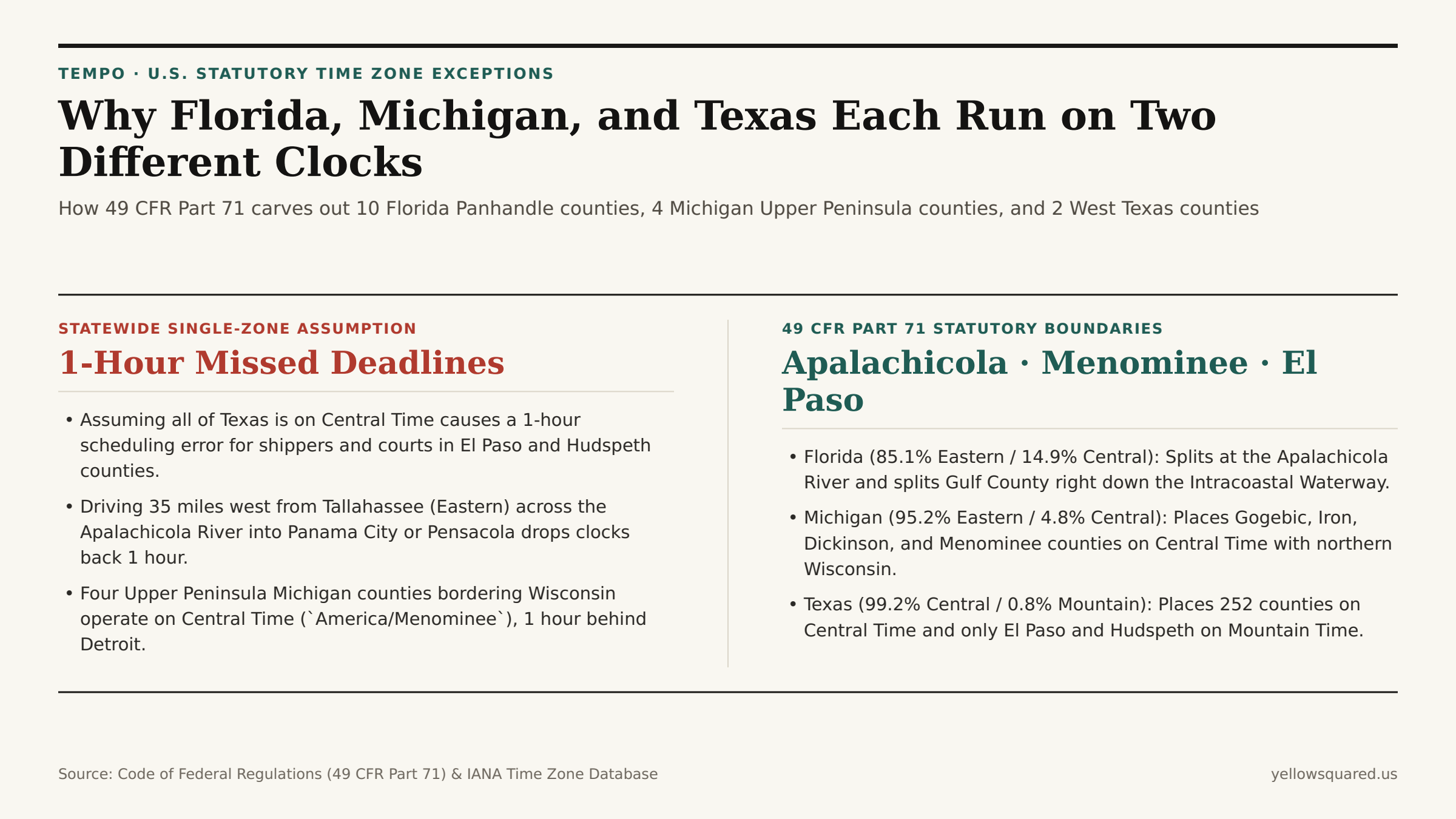
Ask most travelers which time zone governs Florida, Michigan, or Texas, and you will hear a confident one-word answer: Eastern for Florida and Michigan, Central for Texas. Yet under federal law — specifically Title 49, Part 71 of the Code of Federal Regulations (49 CFR Part 71) administered by the U.S. Department of Transportation — all three states are legally split across two time zones to prevent border cities and river basins from operating an hour apart from their nearest metropolitan neighbors.
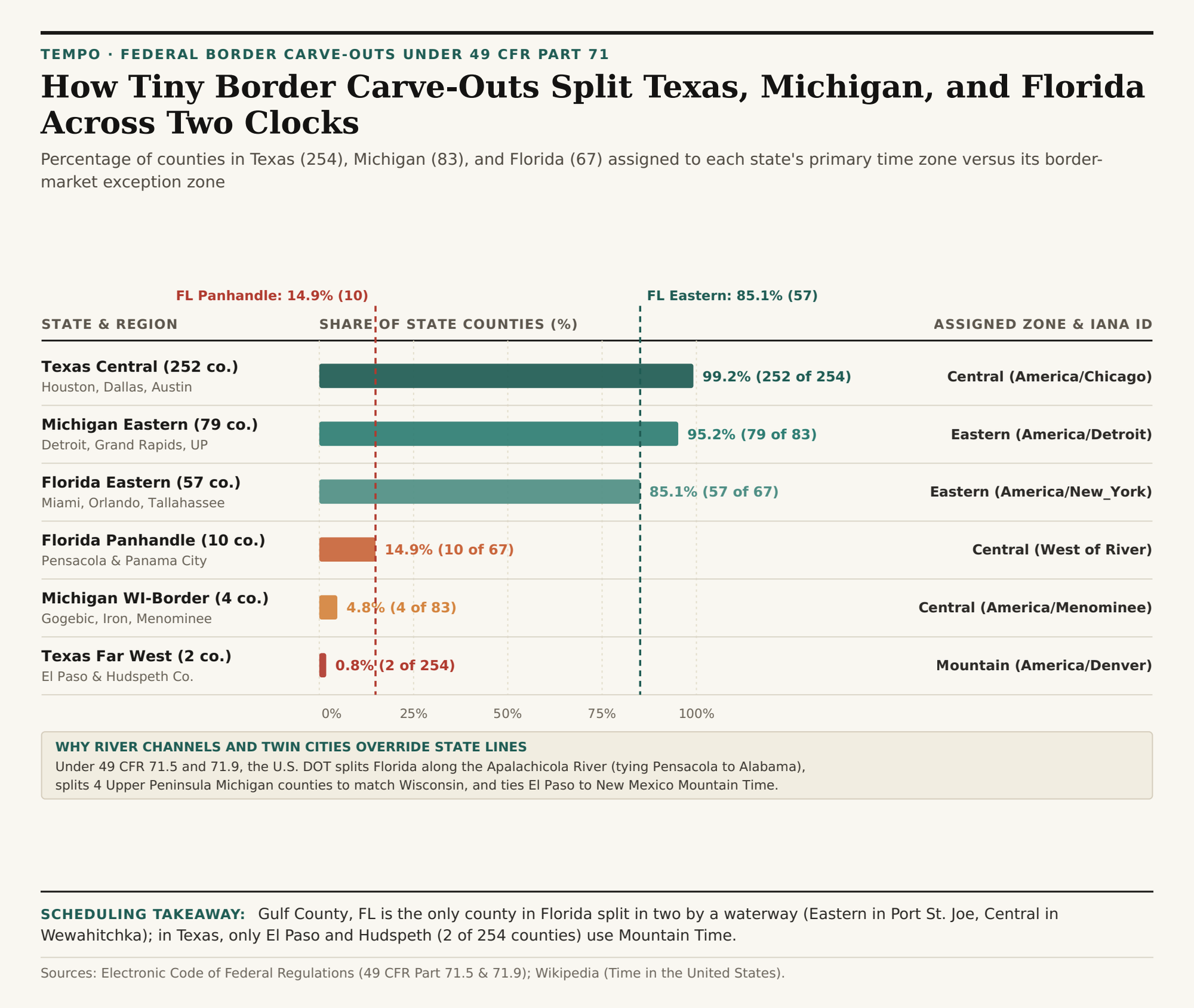
Across the three states, these federal commerce carve-outs place 10 of Florida's 67 counties (14.9%) on Central Time instead of Eastern Time, 4 of Michigan's 83 counties (4.8%) on Central Time instead of Eastern Time, and 2 of Texas's 254 counties (0.8%) on Mountain Time instead of Central Time. Even more remarkably, one county in the Florida Panhandle (Gulf County) is split directly in half along the Intracoastal Waterway. To inspect live clock offsets across split-state counties before booking travel or freight deliveries, Open Tempo in your browser.
1. Florida's Apalachicola River Divide (57 Eastern vs. 10 Central Counties)
Under 49 CFR § 71.5(f) and documented in U.S. Department of Transportation Time Zone Boundary Records, the boundary between Eastern Time (America/New_York) and Central Time (America/Chicago) enters north Florida along the western border of Gadsden County (keeping the state capital of Tallahassee on Eastern Time) and follows the Apalachicola River south toward the Gulf of Mexico.
- The 57 Eastern Time Counties (85.1%): All of peninsular Florida (Miami, Tampa, Orlando, Jacksonville) plus Tallahassee and the Big Bend region east of the Apalachicola River observe Eastern Time (
UTC-5/EDT UTC-4). - The 9 Whole Central Time Counties (13.4%): Jackson, Calhoun, Liberty (west of the river), Bay (Panama City), Washington, Holmes, Walton, Okaloosa, Santa Rosa, and Escambia (Pensacola) observe Central Time (
UTC-6/CDT UTC-5) because their daily commuter, hospital, and television markets tie directly into southern Alabama (Mobile–Pensacola DMA). - Gulf County — The Only Split County in Florida: When the boundary reaches Gulf County near the coast, 49 CFR § 71.5 routes the line along the Gulf Intracoastal Waterway and precision latitude
29°57'03.16"N. The coastal seat of Port St. Joe (32456) runs on Eastern Time, while northern Gulf County around Wewahitchka (32465) runs on Central Time — meaning county offices and schools within the same county operate on two different clocks.
2. Michigan's Four Wisconsin-Border Counties (America/Menominee)
Michigan's Lower Peninsula lies geographically west of the 82.5°W solar meridian, which placed Detroit on Central Time until Detroit petitioned to join Eastern Time in 1915 (codified statewide in 1967–1973). However, four counties along the southwestern edge of Michigan's Upper Peninsula — Gogebic, Iron, Dickinson, and Menominee counties (4.8% of Michigan's 83 counties) — share landline exchanges, hospitals, and river bridges with twin cities in northern Wisconsin (such as Marinette, Wisconsin, directly across the Menominee River from Menominee, Michigan). Under 49 CFR § 71.5(a), those four counties remain on Central Time under the dedicated IANA identifier America/Menominee while the other 11 Upper Peninsula counties (including Marquette and Sault Ste. Marie) observe Eastern Time (America/Detroit).
3. Texas's El Paso & Hudspeth Mountain Time Carve-Out (252 vs. 2 Counties)
Spanning more than 800 miles from the Sabine River (93.5°W) to the Rio Grande bend at El Paso (106.6°W), Texas keeps 252 of its 254 counties (99.2%) on Central Time (America/Chicago). Under 49 CFR § 71.9, only two far-west Trans-Pecos counties — El Paso County and Hudspeth County (0.8%) — are assigned to Mountain Time (America/Denver, UTC-7 / MDT UTC-6). Because El Paso (population ~865,000) forms a contiguous border metropolis with Las Cruces, New Mexico (America/Denver) and Ciudad Juárez, Mexico, placing El Paso on Mountain Time prevents a one-hour jump across the New Mexico state line four miles from downtown.
"Drive east from El Paso on Interstate 10 and you cross from Mountain Time into Central Time at the Culberson County line — jumping ahead one full hour while still more than 500 miles west of Austin and San Antonio."
| State & Sub-Region | 49 CFR Part 71 Boundary | Counties | State Share | Observed Time Zone | IANA Identifier |
|---|---|---|---|---|---|
| Texas Central Majority | East of Hudspeth/Culberson line | 252 of 254 | 99.2% | Central (UTC-6 / UTC-5) | America/Chicago |
| Texas Far West | El Paso & Hudspeth (49 CFR 71.9) | 2 of 254 | 0.8% | Mountain (UTC-7 / UTC-6) | America/Denver |
| Michigan Eastern Majority | Lower Peninsula + 11 UP counties | 79 of 83 | 95.2% | Eastern (UTC-5 / UTC-4) | America/Detroit |
| Michigan WI-Border UP | Gogebic, Iron, Dickinson, Menominee | 4 of 83 | 4.8% | Central (UTC-6 / UTC-5) | America/Menominee |
| Florida Peninsula & East | East of Apalachicola River | 57 of 67 | 85.1% | Eastern (UTC-5 / UTC-4) | America/New_York |
| Florida Western Panhandle | West of Apalachicola / Waterway | 10 of 67 | 14.9% | Central (UTC-6 / UTC-5) | America/Chicago |
Checking Split-State Clocks Before Scheduling
Whenever your team books meetings or freight pickups in Pensacola (Central), Iron Mountain (Central), or El Paso (Mountain), relying on state-level time zone lookup tables will miscalculate arrival windows by a full hour. Open Tempo in your browser to compare exact city-level IANA clocks side by side, and download the 49 CFR Part 71 county split CSV dataset.