
Why Are Samoa and American Samoa 24 Hours Apart Despite Being 40 Miles Away? The 2011 International Date Line Jump
Board a twin-turboprop commuter plane at Faleolo International Airport in Apia, Samoa at 9:00 AM on Tuesday, fly just 40 miles (64 km) east across the ocean to Pago Pago International Airport in American Samoa, and check the clock on the terminal wall when you land 30 minutes later: it is 9:30 AM on Monday — 23 hours and 30 minutes before you took off.
As documented in Wikipedia's Time in Samoa Statutory History, the Samoa Time Zone (UTC-11:00) Reference, and the International Date Line Historical Record, the Independent State of Samoa (Pacific/Apia, UTC+13:00) and the U.S. territory of American Samoa (Pacific/Pago_Pago, UTC-11:00) sit on opposite sides of the International Date Line — creating a full 24-hour calendar gap between two islands in the same archipelago. To compare live dates and hours across Apia, Pago Pago, Auckland, and Honolulu right now, Open Tempo in your browser.
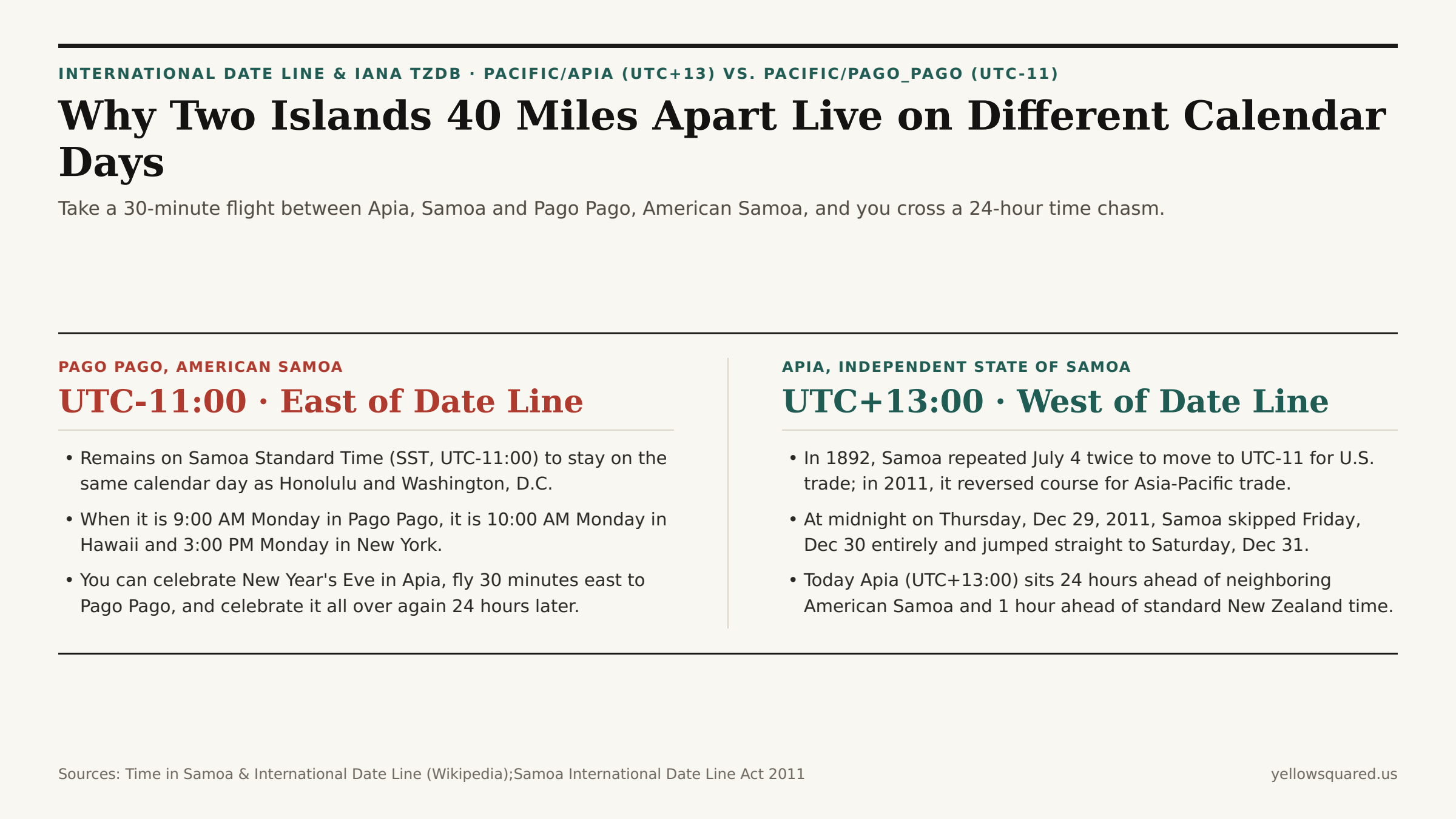
171.8°W) sits slightly west of Pago Pago (170.7°W), Samoa's December 2011 jump across the International Date Line placed Apia 24 hours ahead of American Samoa.1. Why Samoa Switched Sides of the Date Line Twice (1892 and 2011)
How did two neighboring Polynesian islands sharing a language, culture, and family ties end up a full calendar day apart? The story involves two historic economic pivots separated by 119 years (Time in Samoa):
- The 1892 Pivot Toward California (Two Fourths of July): Prior to 1892, European missionaries and traders in Samoa kept Asian/Australian dates (4 hours ahead of Japan). In 1892, American traders persuaded King Malietoa Laupepa to shift Samoa east of the International Date Line (
UTC-11:00) to match steamship schedules from San Francisco. Samoa accomplished that shift by celebrating Monday, July 4, 1892 twice in a row! - The 2011 Pivot Back Toward New Zealand & Australia (The Missing Friday): By the 21st century, Samoa's economic gravity had shifted overwhelmingly toward New Zealand (
UTC+12:00 / +13:00), Australia (UTC+10:00 / +11:00), and East Asia. Sitting onUTC-11:00meant Samoa was 23 hours behind Auckland: when it was Friday afternoon in Apia, banks in Auckland and Sydney were already closed for Saturday; when Auckland opened on Monday morning, Apia was still closed for Sunday — costing Samoan businesses two out of every five working days! - Skipping December 30, 2011: Under the International Date Line Act 2011, at midnight at the end of Thursday, December 29, 2011, the Independent State of Samoa (joined by the New Zealand territory of Tokelau) skipped Friday, December 30, 2011 completely and jumped 24 hours forward from
UTC-11:00toUTC+13:00(Saturday, December 31, 2011). All employees scheduled to work on the vanished Friday were legally paid for the day, and hotel guests were explicitly exempted from paying for the nonexistent night. Meanwhile, American Samoa (a U.S. territory since 1900) stayed onUTC-11:00to remain on the same calendar day as Washington, D.C. and Honolulu.
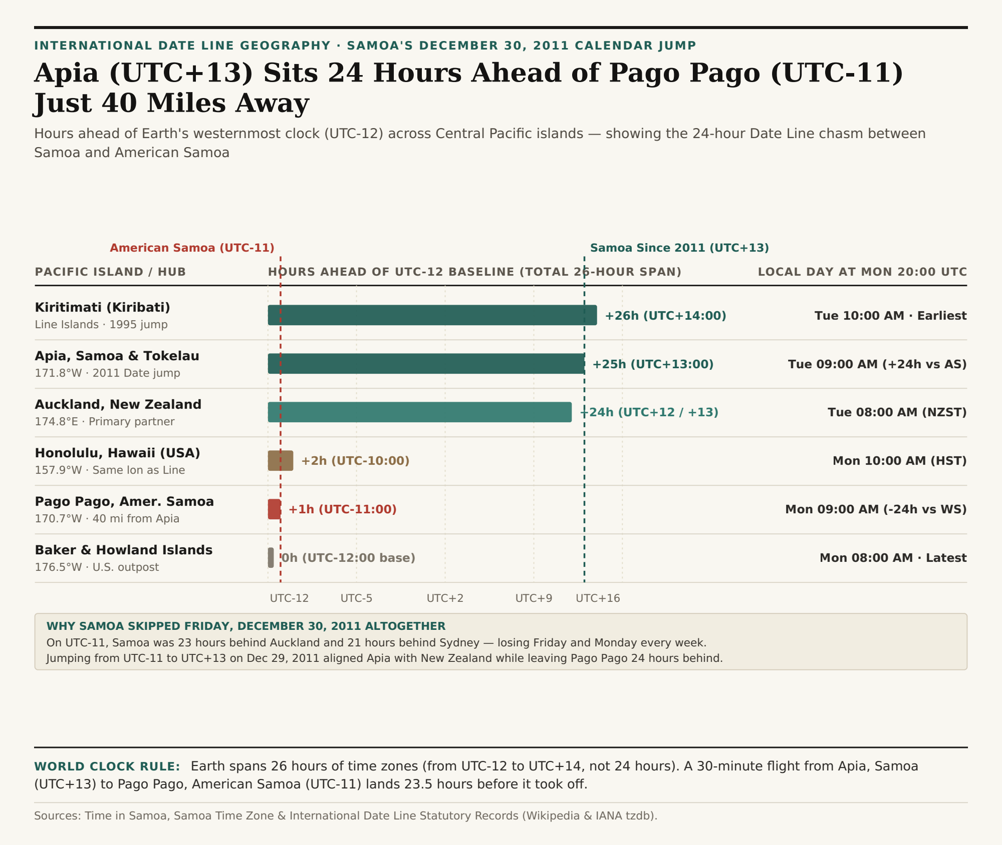
UTC-12:00 baseline across Pacific jurisdictions — illustrating Earth's 26-hour total time-zone span. Download the Samoa & International Date Line dataset (CSV).2. Why Earth Spans 26 Hours of Time Zones (UTC-12 to UTC+14), Not 24
As shown in International Date Line boundary records, Samoa's 2011 shift and Kiribati's earlier January 1, 1995 Date Line realignment (which moved the Line Islands — including Kiritimati / Christmas Island at 157.4°W — to UTC+14:00 so Kiribati wouldn't be split across two days) created a remarkable global quirk:
- Honolulu (
157.9°W) and Kiritimati (157.4°W) Sit on the Exact Same Longitude: Kiritimati lies due south of Oahu along the ~157.5°W meridian. Therefore, both islands share the exact same clock minutes (10:00 AMvs.10:00 AM) — yet Kiritimati (UTC+14:00) is a full 24 hours ahead of Honolulu (UTC-10:00)! - 3 Hours per Day When Three Calendar Dates Coexist on Earth: Because the earliest time zone on Earth is
UTC+14:00(Line Islands) and the latest isUTC-12:00(Baker and Howland Islands), the total span across Earth's time zones is 26 hours. Every day between10:00 UTCand11:59 UTC, three different calendar dates exist simultaneously on Earth (for example, late Monday on Baker Island atUTC-12, Tuesday across Europe/Americas/Asia, and early Wednesday morning in Kiritimati atUTC+14and Apia atUTC+13)!
"Because Apia (UTC+13) and Pago Pago (UTC-11) sit just 40 miles apart on opposite sides of the International Date Line, you can ring in the New Year at midnight in Samoa, board a 30-minute flight to American Samoa, and celebrate New Year's Eve a second time 24 hours later."
| Pacific Jurisdiction | IANA Zone | Longitude | UTC Offset | At Mon 20:00 UTC | Date Line Side & History |
|---|---|---|---|---|---|
| Kiritimati (Line Islands, Kiribati) | Pacific/Kiritimati |
157.4°W | UTC+14:00 | Tue 10:00 AM | West (Jumped Date Line in 1995) |
| Apia, Samoa & Tokelau | Pacific/Apia |
171.8°W | UTC+13:00 | Tue 09:00 AM | West (Skipped Dec 30, 2011) |
| Auckland, New Zealand | Pacific/Auckland |
174.8°E | UTC+12 / +13 | Tue 08:00 AM | West (Primary Polynesia trade hub) |
| Honolulu, Hawaii (USA) | Pacific/Honolulu |
157.9°W | UTC-10:00 | Mon 10:00 AM | East (24h behind Kiritimati at same lon!) |
| Pago Pago, American Samoa | Pacific/Pago_Pago |
170.7°W | UTC-11:00 | Mon 09:00 AM | East (24h behind Apia 40 miles away!) |
| Baker & Howland Islands (USA) | Etc/GMT+12 |
176.5°W | UTC-12:00 | Mon 08:00 AM | East (26h behind Kiritimati) |
Checking Date-Line Crossings Before You Book
Whether you are coordinating South Pacific flights between Auckland (UTC+12/+13), Apia (UTC+13), Fiji (UTC+12), and Pago Pago (UTC-11), or verifying whether a remote teammate in Oceania is already on tomorrow's calendar date, Open Tempo in your browser to inspect live day-and-hour badges side by side, and download the Samoa & International Date Line CSV dataset.