
Why Did Samoa Skip Friday, December 30, 2011—And Why Is American Samoa 24 Hours Behind Just 40 Miles Away?
Look up the calendar for the Independent State of Samoa in December 2011, and you will discover a missing day: Friday, December 30, 2011 never existed. When church bells and sirens rang across Apia at 11:59:59 PM on Thursday, December 29, 2011, clocks did not advance to Friday morning—they leaped 24 hours forward to 12:00:00 AM on Saturday, December 31, 2011. As documented in the historical registries of Time in Samoa, Daylight Saving Time in Samoa, the International Date Line, and contemporary reporting by The Guardian and CBC News, Samoa (joined by the New Zealand territory of Tokelau) redrew the International Date Line from 84 kilometers west of its shores to 40 kilometers east of its shores—splitting the Samoan archipelago into two time zones separated by 24 hours across a 40-mile strait.
Why did Samoa switch sides of the International Date Line twice in 119 years—first by celebrating July 4, 1892 twice, and then by erasing December 30, 2011—and how can you celebrate your birthday twice on a 25-minute twin-prop flight between Apia and Pago Pago? Here is the complete geopolitical and timekeeping story.
1. The 1892 Double Fourth of July: Why Samoa Was on the American Side in the First Place
Geographically, the entire Samoan archipelago sits near longitude 171°W to 172°W—roughly 8 degrees east of the 180° antimeridian. Before 1892, European mariners and missionaries who reached Samoa from the west kept Asian/Australasian calendar dates (four hours ahead of Japan, on the west side of the Date Line).
However, as recorded in Wikipedia's International Date Line history, late-19th-century American trading houses operating steamships out of San Francisco persuaded King Mālietoa Laupepa that Samoa should align its calendar with California (three hours behind Pacific Standard Time). To move from the Asian side of the Date Line to the American side (UTC-11:00), Samoa had to repeat a calendar day—and it chose Monday, July 4, 1892, American Independence Day, giving 1892 two consecutive Fourths of July and a 367-day calendar year.
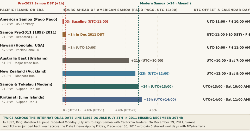
UTC-11:00) across Pacific hubs before and after Samoa and Tokelau skipped Friday, December 30, 2011 (Wikipedia — Time in Samoa; International Date Line).2. The Three-Day Business Week Problem: Why Prime Minister Tuilaepa Erased December 30, 2011
Over the next 119 years, Samoa's economic gravity shifted completely away from California toward New Zealand (UTC+12:00 / UTC+13:00 NZDT), Australia (UTC+10:00 / UTC+11:00 AEDT), and East Asia. By 2011, sitting on UTC-11:00 created an expensive scheduling trap documented by The Guardian and Time in Samoa:
- Losing Two Workdays Every Single Week: Because Samoa was 21 to 23 hours behind Sydney and Auckland, when it was Friday in Apia, banks and port authorities in Auckland and Sydney were already closed for Saturday. Conversely, when New Zealand businesses opened on Monday morning, it was still Sunday morning in Samoa. Instead of a five-day international workweek, Samoan exporters and families had only three full overlapping business days per week (Tuesday, Wednesday, and Thursday in NZ/Australia corresponding to Monday, Tuesday, and Wednesday in Samoa).
- The Statutory Jump at Midnight on December 29, 2011: Under the International Date Line Act 2011 spearheaded by Prime Minister Tuilaepa Sailele Malielegaoi, Samoa jumped 24 hours forward at the end of Thursday, December 29, 2011—moving its standard time from
UTC-11:00toUTC+13:00(and its summer Daylight Saving Time, observed from 2010 until its permanent abolition in 2021, fromUTC-10:00toUTC+14:00). - Paid Missing Friday & Tokelau's Simultaneous Leap: As noted in Daylight Saving Time in Samoa, all employees scheduled to work on the nonexistent Friday, December 30, 2011 were guaranteed a full day's wage by law, while roughly 500 Samoan citizens born on December 30 skipped their 2011 birthday. Because the New Zealand territory of Tokelau (
Pacific/Fakaofo) relies on Apia for transport and administration, Tokelau skipped December 30, 2011 right alongside Samoa, shifting fromUTC-11:00toUTC+13:00year-round (UTC+13:00 registry).
"At the end of Thursday, 29 December 2011, Samoa continued directly to Saturday, 31 December 2011, skipping the entire calendar day of Friday, 30 December 2011 and effectively redrawing the International Date Line."
3. The 40-Mile, 24-Hour Paradox Between Samoa and American Samoa
While independent Samoa (Pacific/Apia) jumped to the west side of the Date Line, neighboring American Samoa (Pacific/Pago_Pago)—an unincorporated territory of the United States located just 40 miles (64 km) across the ocean at its closest island point (and ~77 miles airport-to-airport from Faleolo APW to Pago Pago PPG)—remained on the American side at UTC-11:00 (UTC-11:00).
Since Samoa ended seasonal Daylight Saving Time in 2021 and locked its clocks permanently at UTC+13:00, the two neighbors exhibit one of the most mind-bending relationships in global travel:
- Identical Wall-Clock Time, One Full Day Apart: Because
+13 - (-11) = +24 hours, the minute and hour hands on wall clocks in Apia and Pago Pago show the exact same time of day all year round—when it is10:15 AMin Apia, it is10:15 AMin Pago Pago—except Apia is on Saturday while Pago Pago is still on Friday! - Time-Travel Aviation in 25 Minutes: Board a 25-minute inter-island flight from Apia (
APW) at12:00 PM Saturday, and you touch down in Pago Pago (PPG) at12:25 PM Friday—23 hours and 35 minutes before you took off, allowing travelers to celebrate New Year's Eve or a birthday twice within a single hour of flying.
4. Complete Data Table: Samoa, American Samoa & Pacific Date Line Zones
The reproducible table below—matching the companion CSV (samoa-december-30-2011-date-line-jump-and-pacific-24-hour-time-gaps.csv)—compares the UTC offsets, longitudes, and calendar relationships across the central Pacific Date Line corridor:
| Pacific Territory or Era | IANA tzdb Zone |
Longitude | Standard Offset | Gap vs. American Samoa | Local Time When Pago Pago Is Fri 10:00 AM | Date Line & Trade Alignment Note |
|---|---|---|---|---|---|---|
| American Samoa (Pago Pago) | Pacific/Pago_Pago |
170.70°W |
UTC-11:00 (No DST) |
Baseline (0 hr) | Friday 10:00 AM | US territory; stayed east of the Date Line |
| Samoa Pre-2011 (1892–2011) | Pacific/Apia (Historical) |
171.76°W |
UTC-11:00 (-10 DST) |
0 hr (+1 hr in DST) |
Friday 10:00 AM (11:00 AM DST) | Repeated Monday, July 4, 1892 for US trade |
| Hawaii (Honolulu) | Pacific/Honolulu |
157.86°W |
UTC-10:00 (No DST) |
1 hr ahead | Friday 11:00 AM | 23 hours behind modern Apia |
| Australia East (Brisbane / Sydney) | Australia/Brisbane |
151.21°E |
UTC+10:00 (+11 AEDT) |
21 hr ahead (22h DST) |
Saturday 7:00 AM (8:00 AM AEDT) | Only 3 shared workdays/week with pre-2011 Samoa |
| New Zealand (Auckland) | Pacific/Auckland |
174.76°E |
UTC+12:00 (+13 NZDT) |
23 hr ahead (24h DST) |
Saturday 9:00 AM (10:00 AM NZDT) | Primary Samoan trade & expat hub |
| Samoa & Tokelau (Modern) | Pacific/Apia · Pacific/Fakaofo |
171.76°W |
UTC+13:00 (No DST) |
24 hr ahead! | Saturday 10:00 AM! | Skipped Friday, Dec 30, 2011; abolished DST in 2021 |
| Kiribati Line Islands (Kiritimati) | Pacific/Kiritimati |
157.40°W |
UTC+14:00 (No DST) |
25 hr ahead! | Saturday 11:00 AM! | Skipped Dec 31, 1994; 25 hours ahead of Pago Pago |
When you are planning flights or remote meetings across the International Date Line between Honolulu (UTC-10), Pago Pago (UTC-11), Apia (UTC+13), and Auckland (UTC+12/+13), Open Tempo in your browser to see exact calendar-day boundaries side by side.