
Why Are Indiana and Kentucky Split Between Eastern and Central Time?
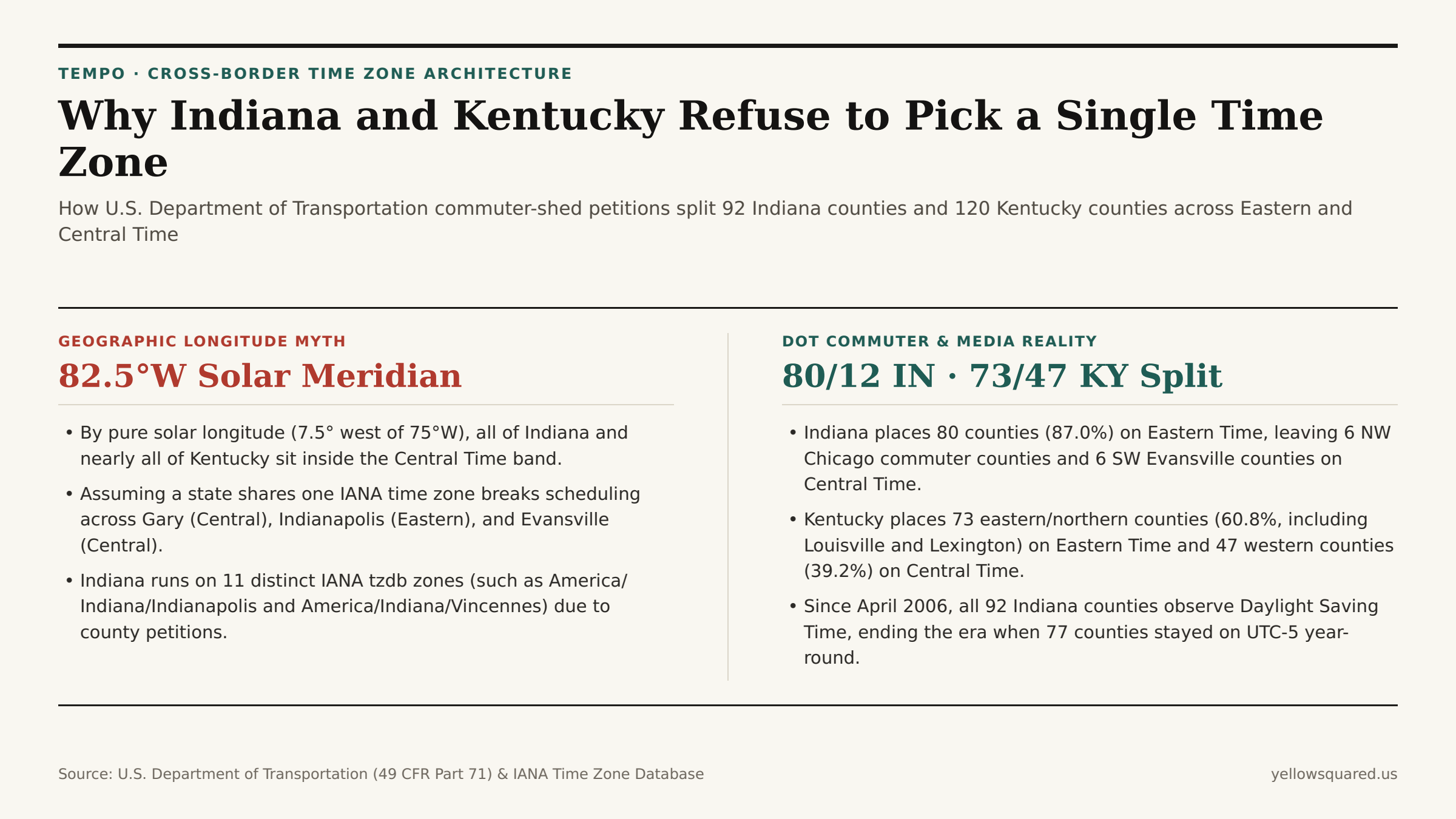
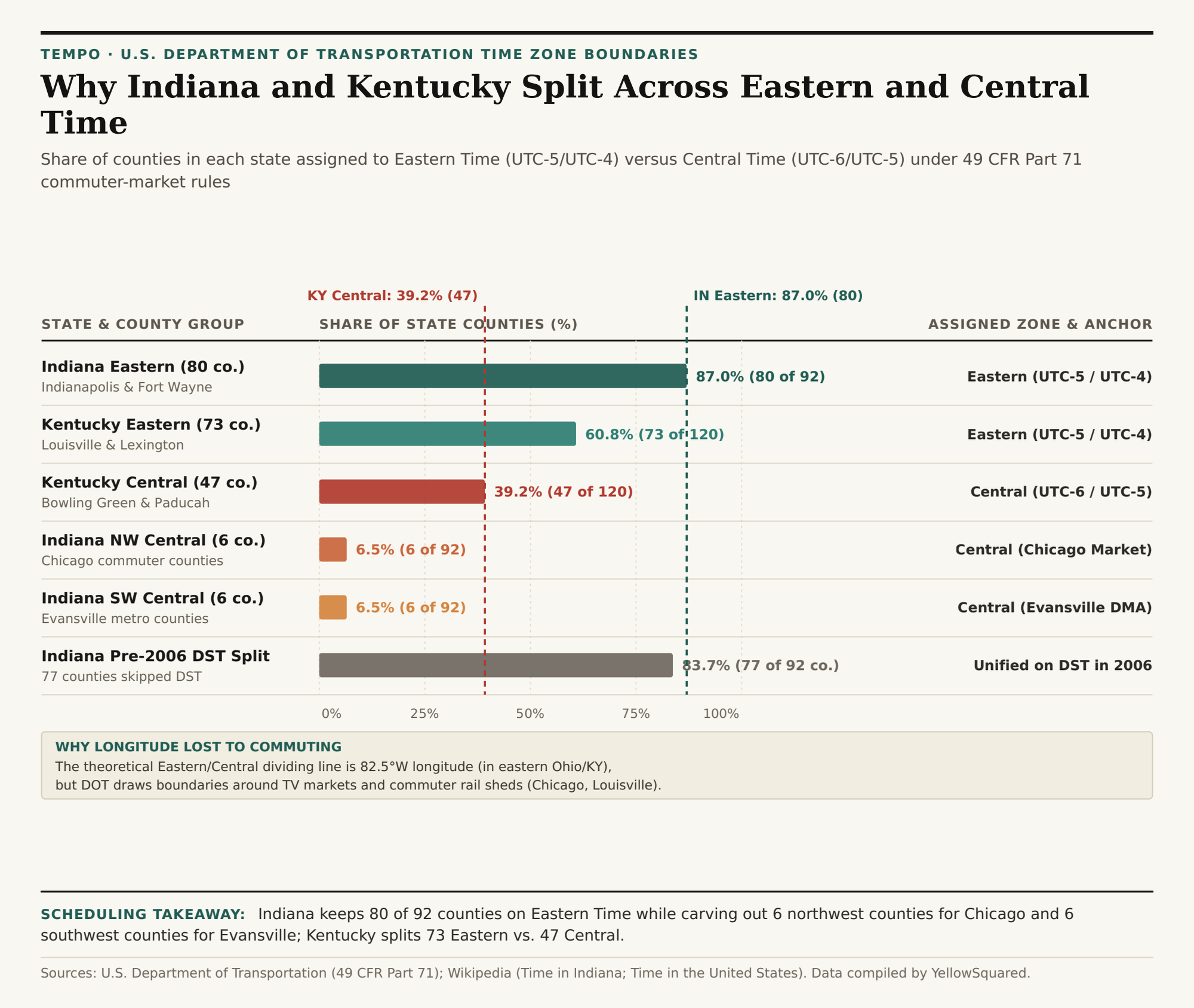
Drive ninety minutes southeast from downtown Chicago into Indiana, or two hours west from Louisville across Kentucky, and your phone clock will jump back a full hour without crossing a state line. Under U.S. Department of Transportation (DOT) time zone regulations (49 CFR Part 71), 80 of Indiana's 92 counties (87.0%) observe Eastern Time while 12 counties (13.0%) observe Central Time, and 73 of Kentucky's 120 counties (60.8%) observe Eastern Time while 47 western counties (39.2%) remain on Central Time.
If time zones followed pure solar geometry, neither state would be in Eastern Time at all. Because Earth rotates 15 degrees of longitude per hour, Eastern Standard Time (UTC-5) is centered on the 75th meridian west (near Philadelphia), making the theoretical boundary with Central Standard Time (UTC-6, centered on 90°W) the 82.5°W meridian — a line that runs through eastern Ohio and clips only the easternmost tip of Pike County, Kentucky. Every square mile of Indiana (which lies between 84°47'W and 88°06'W) sits geographically inside the solar Central Time band. Yet over the past century, federal commerce statutes traded longitudinal symmetry for metropolitan commuter and television market cohesion. To see how county-level time boundaries affect cross-state meetings right now, Open Tempo in your browser and compare live IANA zone offsets side by side.
How Commuter Rail and Broadcast Markets Redrew the Map
When Congress passed the Standard Time Act of 1918 and later transferred regulatory authority from the Interstate Commerce Commission to the U.S. Department of Transportation via the Uniform Time Act of 1966, it established a single statutory criterion for moving a county between time zones: the convenience of commerce. When county commissioners petition the DOT for a time zone reassignment, federal examiners do not measure solar noon; instead, they audit where residents commute to work, where hospitals and wholesale suppliers are located, and which Designated Market Area (DMA) supplies local television news and school-closing broadcasts.
As documented in the historical record of Time in Indiana, this commerce test created a three-way geographic split across Indiana's 92 counties:
- The 80 Eastern Time Counties (UTC-5 / EDT UTC-4): Stretching from Indianapolis and Fort Wayne to South Bend and the Louisville metro counties (Clark, Floyd, and Harrison), 87.0% of Indiana's counties align their clocks with Ohio, Michigan, and East Coast financial markets.
- The 6 Northwest Central Time Counties (UTC-6 / CDT UTC-5): Lake, Porter, LaPorte, Newton, Jasper, and Starke counties form the Indiana commuter belt of metropolitan Chicago. Because tens of thousands of Northwest Indiana residents ride the South Shore Line commuter rail into Chicago daily and watch Chicago network television, keeping those six counties on Central Time prevents a one-hour border jump across the Illinois state line.
- The 6 Southwest Central Time Counties (UTC-6 / CDT UTC-5): Vanderburgh, Posey, Warrick, Gibson, Spencer, and Perry counties anchor the Evansville tri-state metro area, whose labor shed and television broadcast footprint interlock directly with southern Illinois and western Kentucky (Henderson and Daviess counties), both of which operate on Central Time.
Why Indiana Has 11 Distinct IANA Time Zone Identifiers
For software engineers and distributed scheduling systems, Indiana is famous for occupying 11 separate America/Indiana/* and America/* entries inside the IANA Time Zone Database (tzdb). Before April 2006, 77 of Indiana's 80 Eastern Time counties refused to observe Daylight Saving Time, remaining locked on Eastern Standard Time (UTC-5) all year — which meant Indianapolis matched New York in winter and Chicago in summer. Meanwhile, five Ohio River counties near Cincinnati and Louisville observed DST unofficially, and several rural counties switched between Eastern and Central Time between 2005 and 2007.
"Because historical timestamps before 2007 depend on which exact Indiana county recorded the event, the IANA database preserves separate zone files for Vincennes, Petersburg, Tell City, Knox, Winamac, Marengo, Vevay, and Indianapolis."
In Kentucky, the boundary runs diagonally from Breckinridge and Grayson counties near the Ohio River down to Wayne and McCreary counties on the Tennessee border. The 73 Eastern Time counties (60.8%) encompass Kentucky's "Golden Triangle" of Louisville, Lexington, and Northern Kentucky (across the river from Cincinnati), while the 47 Central Time counties (39.2%) cover Bowling Green, Owensboro, Hopkinsville, and Paducah, aligning western Kentucky with Nashville, Tennessee (America/Chicago).
| Region / County Group | State | Counties | State Share | Observed Time Zone | Primary Commuter / TV Market Anchor |
|---|---|---|---|---|---|
| Indiana Eastern Counties | Indiana | 80 of 92 | 87.0% | Eastern (UTC-5 / UTC-4) | Indianapolis, Fort Wayne, South Bend & Louisville |
| Indiana NW Central Counties | Indiana | 6 of 92 | 6.5% | Central (UTC-6 / UTC-5) | Chicago Metro (Lake, Porter, LaPorte, Newton, Jasper, Starke) |
| Indiana SW Central Counties | Indiana | 6 of 92 | 6.5% | Central (UTC-6 / UTC-5) | Evansville Tri-State (Vanderburgh, Posey, Warrick, Gibson, Spencer, Perry) |
| Kentucky Eastern Counties | Kentucky | 73 of 120 | 60.8% | Eastern (UTC-5 / UTC-4) | Louisville, Lexington & Northern Kentucky (Cincinnati Metro) |
| Kentucky Western Counties | Kentucky | 47 of 120 | 39.2% | Central (UTC-6 / UTC-5) | Bowling Green, Owensboro, Paducah & Nashville Commuter Belt |
Practical Rules for Cross-Border Logistics and Remote Teams
Whenever you coordinate freight windows along Interstate 65 (which crosses from Central Time in Gary, Indiana, to Eastern Time near Lafayette, stays in Eastern Time through Indianapolis and Louisville, and then crosses back into Central Time north of Bowling Green, Kentucky), state abbreviations alone are never enough to determine local clock time. Always store and query schedules by city or county IANA identifier. To verify exact UTC offsets and DST transitions across split-state corridors, Open Tempo in your browser or download the reproducible county boundary CSV table.