
Why Does Hail Fall in the Middle of Summer—When It's 90°F on the Ground?
It is one of the most counterintuitive spectacles in meteorology: on a sweltering late-spring or mid-summer afternoon when the thermometer on your porch reads 88°F to 95°F (31°C–35°C), the sky turns bruised green-black and solid chunks of ice the size of quarters, golf balls, or baseballs Begin hammering roofs and windshields. Why does big hail fall in the heat of summer rather than in the middle of a freezing January blizzard? As explained by the NOAA National Severe Storms Laboratory (NSSL) in Severe Weather 101: Hail Basics and Severe Weather 101: Hail Types, along with microphysical analyses from the Bureau of Economic Geology's EarthDate program and StarView, growing a multi-inch ice stone requires two ingredients that winter snowstorms almost never have: 50 to 100+ mph vertical updrafts fueled by hot surface air, and a thick reservoir of supercooled liquid water between 14°F and -13°F (-10°C to -25°C) high in the troposphere.
Here is the step-by-step atmospheric physics of how summer heat builds giant ice three to six miles above your head—and why a hailstone falling at 44 to 100+ mph reaches the ground before a 90°F afternoon can melt it.
1. Why Winter Makes Snow and Sleet, While Summer Makes Hail
In winter, the entire atmospheric column from the clouds down to your driveway is near or below freezing (32°F / 0°C). While that sounds ideal for making ice, cold surface air is dense, heavy, and thermodynamically stable. As NOAA NSSL's precipitation classification explains, winter storms lack the violent vertical updrafts needed to hold heavy ice stones aloft:
- Snow (Vapor Deposition): Forms when water vapor transitions directly into six-sided ice crystals without passing through a liquid phase inside gentle stratus or frontal updrafts.
- Sleet (Ice Pellets): Forms during winter warm-nose inversions when snowflakes partially melt into liquid drops mid-air and refreeze into small translucent pellets before hitting the ground.
- Graupel ("Soft Hail" / Snow Pellets,
< 0.20 inches): Forms when supercooled liquid droplets freeze onto a falling snowflake (a process called riming). Because winter updrafts are weak, graupel pellets fall out of the cloud while still tiny (< 0.20 in / 5 mm) and crumble softly when pinched. - True Hail (Convective Accretion,
0.25to8.00 inches): Requires a towering cumulonimbus or rotating supercell thunderstorm (often reaching40,000to50,000 feet/15 kmtall, per StarView's NSSL summary). Hot, humid summer air near the ground provides massive Convective Available Potential Energy (CAPE). As that buoyant warm air rockets upward at40to100+ mph, it carries liquid raindrops past the freezing level (typically10,000–14,000 feetabove ground in summer) into sub-zero air.
2. Inside the 14°F to -13°F Hail Growth Zone: Why Hailstones Have Onion Rings
Even above the 32°F (0°C) freezing level, pure liquid water droplets suspended in an updraft do not freeze right away. Without a solid ice crystal or dust nucleus to latch onto, cloud droplets remain supercooled liquid water down to -40°F (-40°C). As documented by EarthDate's hail microphysics review and MDPI's structural hail impact research, the sweet spot for rapid hailstone growth sits at altitudes where updraft temperatures range from 14°F to -13°F (-10°C to -25°C):
- Clear Ice Rings ("Wet Growth" Near
14°Fto32°F): In the lower, slightly warmer half of the freezing zone, colliding supercooled water droplets do not freeze instantaneously upon hitting the hailstone. Because freezing releases latent heat of fusion, a thin skin of liquid water coats the tumbling stone and freezes slowly—allowing dissolved air bubbles to escape and forming a rock-hard, transparent ring of clear ice. - Cloudy White Rings ("Dry Growth" Near
-4°Fto-25°F): When the updraft lofts the hailstone higher into bitterly cold regions of the storm, supercooled droplets freeze the instant they touch the stone's surface. Microscopic air bubbles are trapped inside the ice matrix, creating an opaque, milky-white rime layer. - 30 Minutes in a Rotating Supercell Vault: In an ordinary single-cell summer storm, a hailstone makes one trip through the growth zone and falls as pea- or marble-sized hail. In a rotating supercell (up to 10 miles wide and 50,000 feet tall), a tilted, rotating updraft ("vault") suspends and recirculates hail embryos across wet-growth and dry-growth regions for up to 30 minutes—building alternating onion-like rings until the stone grows too heavy for the updraft to support.
"Updrafts counter the pull of gravity to keep the tiny hail embryos aloft where they grow by colliding with more supercooled water droplets in the hail growth zone, where temperatures within the updrafts are 14°F to -13°F (-10°C to -25°C)."
3. Why Doesn't Hail Melt Before Hitting 90°F Ground?
Actually, most small hail does melt—thousands of summer thunderstorms manufacture pea-sized hail at 20,000 feet that melts completely into big cold raindrops before reaching your lawn. Large hail survives the warm lower atmosphere for three physical reasons:
- Cube-Square Mass vs. Surface-Area Scaling: A hailstone's thermal mass (the amount of ice that must absorb latent heat to melt) scales with its volume (
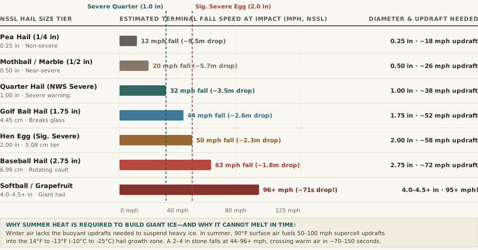
r^3), whereas heat transfer from warm air scales with surface area (r^2). Doubling a hailstone's diameter from0.5 inchto1.0 inchmultiplies its ice mass by 8 times while multiplying its surface area by only 4 times. - 44 to 100+ MPH Terminal Velocity Means Only ~70–150 Seconds in Warm Air: As StarView's NSSL velocity breakdown notes, a
2 to 4 inchhailstone falls at44 to 72+ mph, and stones over4 inchesexceed100 mph (161 km/h). If the freezing level sits11,000 feetabove the ground, a golf-ball stone falling at44 mph(64.5 ft/sec) spends less than 2.8 minutes in above-freezing air, and a softball stone falling at96 mph(141 ft/sec) slices through the entire warm layer in 78 seconds! - Evaporative Cooling in the Downdraft: Hail falls inside the storm's precipitation core alongside torrential rain and cold downdraft air that has already been cooled by melting ice and evaporating rain.
4. Complete Data Table: Official NOAA / NWS Hail Size Tiers, Updrafts & Fall Speeds
The reproducible table below—matching the companion CSV (summer-hail-sizes-updraft-speeds-and-terminal-fall-velocity-nssl-noaa.csv)—compiles the official NOAA NSSL object size chart, NWS severe weather thresholds, and terminal fall speeds:
| NSSL Object Reference | Diameter (in / cm) | NWS Alert Classification | Updraft Speed Needed | Terminal Fall Speed | Drop Time Below 11,000 ft |
Documented Impact Benchmark (NOAA NSSL) |
|---|---|---|---|---|---|---|
| Pea | 0.25 in (0.64 cm) |
Non-Severe Small Hail | ~15–20 mph |
~12 mph |
~9.5 min |
Heavy melting in summer boundary layer; strips garden leaves |
| Mothball / Marble | 0.50 in (1.27 cm) |
Approaching Severe (≥0.50 in) |
~24–28 mph |
~20 mph |
~5.7 min |
Triggers NWS Special Weather Statement; bruises orchard fruit |
| Penny / Nickel | 0.75–0.88 in |
Legacy Pre-2010 Severe Tier | ~30–34 mph |
~27 mph |
~4.3 min |
Strips shingle granules; minor dings on thin aluminum trim |
| Quarter (Severe Cutoff) | 1.00 in (2.54 cm) |
NWS Severe Thunderstorm (≥1.0 in) |
~35–40 mph |
~32 mph |
~3.5 min |
Official NWS Severe Warning cutoff; dents car hoods and gutters |
| Ping-Pong / Golf Ball | 1.50–1.75 in (4.4 cm) |
Severe Supercell Hail | ~48–55 mph |
~44 mph |
~2.6 min |
Cracks laminated car windshields; totals auto body panels |
| Hen Egg (Sig. Severe) | 2.00 in (5.08 cm) |
Significant Severe (≥2.0 in) |
~55–62 mph |
~50 mph |
~2.3 min |
Shatters skylights, solar panels, and clay/concrete roof tiles |
| Tennis Ball / Baseball | 2.50–2.75 in (7.0 cm) |
Significant Severe Supercell | ~68–75 mph |
~63 mph |
~1.8 min |
Splits plywood roof sheathing; life-threatening head injury hazard |
| Softball to Grapefruit | 4.00–4.50+ in (10.2+ cm) |
Giant Hail (Record: 8.0 in Vivian, SD) |
~90–105+ mph |
~72–100+ mph |
~1.2 min |
Vivian, SD record stone (June 23, 2010) measured 8.0 in / 1 lb 15 oz |
To track seasonal temperature normals, convective heat anomalies, and historical precipitation extremes across your region, Compare atmospheric normals in Eranorms.