
Why Does Indiana Have Two Time Zones? The Eastern vs. Central Split
Why Does Indiana Have Two Time Zones? The Eastern vs. Central Split
Although Indiana sits geographically near the 86°W Central meridian, 80 of its 92 counties observe Eastern Time (UTC-5 / UTC-4) while 12 counties in the northwest (Chicago metro) and southwest (Evansville metro) observe Central Time (UTC-6 / UTC-5).
Look at a standard time zone map of the United States and follow the boundary between the Eastern and Central time zones. Instead of running straight down the Indiana–Illinois state line, the border carves out two separate pockets inside western Indiana—leaving 80 Indiana counties on Eastern Time and 12 counties split between the northwestern and southwestern corners on Central Time. Drive south from Gary to Indianapolis to Evansville, and you will cross time zones twice without ever leaving the state.
Even more remarkably, software engineers who work with the IANA Time Zone Database (`tzdb`) know that Indiana accounts for 11 of the 29 historical time zone identifiers in the entire United States (`America/Indiana/*`). Understanding how a state located squarely on the Central solar meridian ended up anchored to New York City time—and why 12 counties refused to go along—explains one of America's fiercest clock battles.
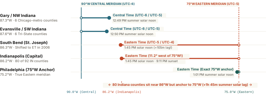
The Solar Math: Why 86°W Belongs to Central Time by the Sun
Astronomically, global time zones are spaced every 15 degrees of longitude west of Greenwich (`0°`):
- Eastern Time (`UTC-5` winter / `UTC-4` summer): Centered on the 75.0°W meridian running near Philadelphia.
- Central Time (`UTC-6` winter / `UTC-5` summer): Centered on the 90.0°W meridian running near St. Louis and New Orleans.
Because the dividing line between the two zones sits halfway at 82.5°W (running through central Ohio), the entire state of Indiana—spanning roughly `84.8°W` to `88.1°W`, with Indianapolis at `86.16°W`—lies well inside the natural Central Time zone. When Indianapolis observes Eastern Daylight Time (`UTC-4`, anchored to the `60°W` Atlantic meridian in summer), true solar noon does not arrive until 1:45 PM on the clock, and midsummer sunset stretches past 9:11 PM.
From 1970 until 2006, most of Indiana solved its geographic mismatch by staying on Eastern Standard Time (UTC-5) year-round without Daylight Saving Time—matching New York in winter and Chicago in summer.
The 12 Central Counties and the 2006 DST Showdown
For decades, commercial broadcasters and corporate executives in Indianapolis lobbied to align the state with East Coast financial markets, while farmers and parents opposed the dark autumn mornings caused by Eastern Daylight Time. In April 2006, following passage of a contentious state law and U.S. Department of Transportation rulemaking (`71 FR 3228`), Indiana adopted statewide Daylight Saving Time for the first time since 1970—leaving the state divided into three groups:
- 80 Eastern Time Counties (`America/Indiana/Indianapolis`): Includes Indianapolis, Fort Wayne, Bloomington, Lafayette, and Muncie—plus five northern counties around South Bend (`St. Joseph`, `Elkhart`, `Marshall`, `Fulton`, and `Leaderboard/Kosciusko`) that shifted from unofficial Central association onto full Eastern Time.
- 6 Northwestern Central Counties (`America/Chicago`): Lake, Porter, LaPorte, Newton, Jasper, and Starke counties are economically integrated into the Chicago metropolitan commuter rail and media market, keeping them firmly on Central Time.
- 6 Southwestern Central Counties (`America/Chicago`): Vanderburgh (Evansville), Posey, Warrick, Spencer, Gibson, and Perry counties sit in the tri-state Ohio River basin bordering Illinois and Kentucky (both on Central Time).
When scheduling regional meetings between Chicago, Northwest Indiana, Indianapolis, and Louisville, you can Open Tempo in your browser to verify exact county-level UTC offsets without guessing which side of the line a client sits on.