
Why Does It Hail in the Summer? The Physics of Warm-Season Ice
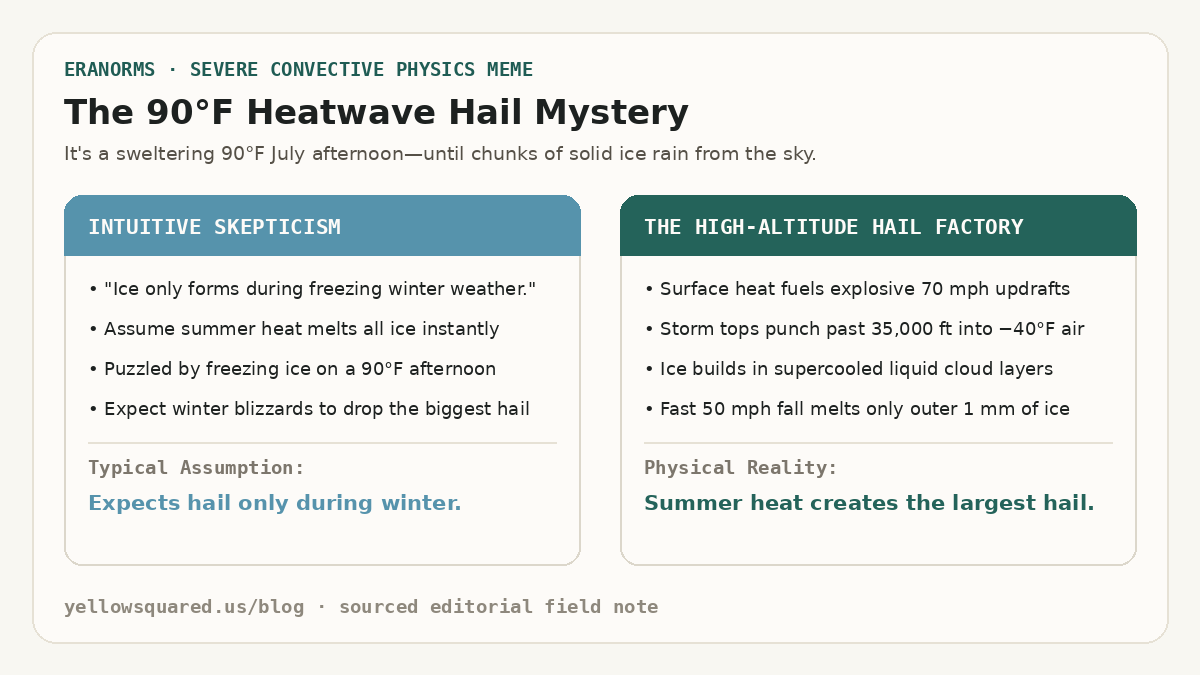
When a sudden summer thunderstorm rolls across a sunbaked city, people expect heavy rain, gusty winds, and lightning. But when golf-ball-sized chunks of solid ice bounce off cars on an 88°F (31°C) July afternoon, it feels like a violation of the laws of physics. Why does the largest, most damaging hail happen at the peak of summer heat rather than during sub-freezing winter blizzards? According to convective sounding records from the NOAA National Severe Storms Laboratory (NSSL), the answer lies in an atmospheric paradox: summer heat is the exact engine required to build hail.
Hail cannot form in ordinary rainclouds or gentle winter snow showers. It requires immense convective instability—fueled by sweltering surface temperatures and high humidity—to launch violent thunderstorm updrafts exceeding 50 to 80 miles per hour. These updrafts shoot moisture thirty to fifty thousand feet into the troposphere, where temperatures plunge to −40°F (−40°C) even on the hottest summer days.
Winter blizzards produce snowflakes and soft sleet; it takes the explosive energy of a ninety-degree summer heatwave to create the vertical jet engine that manufactures true hailstones.
How Summer Heat Acts as an Updraft Engine
To create hail, an air parcel must rise violently. On a hot summer afternoon, intense solar radiation heats the ground, which in turn superheats the boundary layer of air directly above it. Because warm air is less dense than cold air, it becomes buoyant. When a passing weather front or mountain breeze triggers this unstable air, it rockets upward like a hot-air balloon.
Meteorologists measure this energy as Convective Available Potential Energy (CAPE). In typical winter storms, CAPE rarely exceeds 200 Joules per kilogram. In severe summer supercells, CAPE routinely surpasses 2,500 to 4,000 J/kg, generating updraft speeds between 50 and 90 miles per hour (22 to 40 meters per second). Without that summer heat engine, storm clouds cannot support the weight of growing ice.
Inside the Cloud: The Freezing Level and the Hail Factory
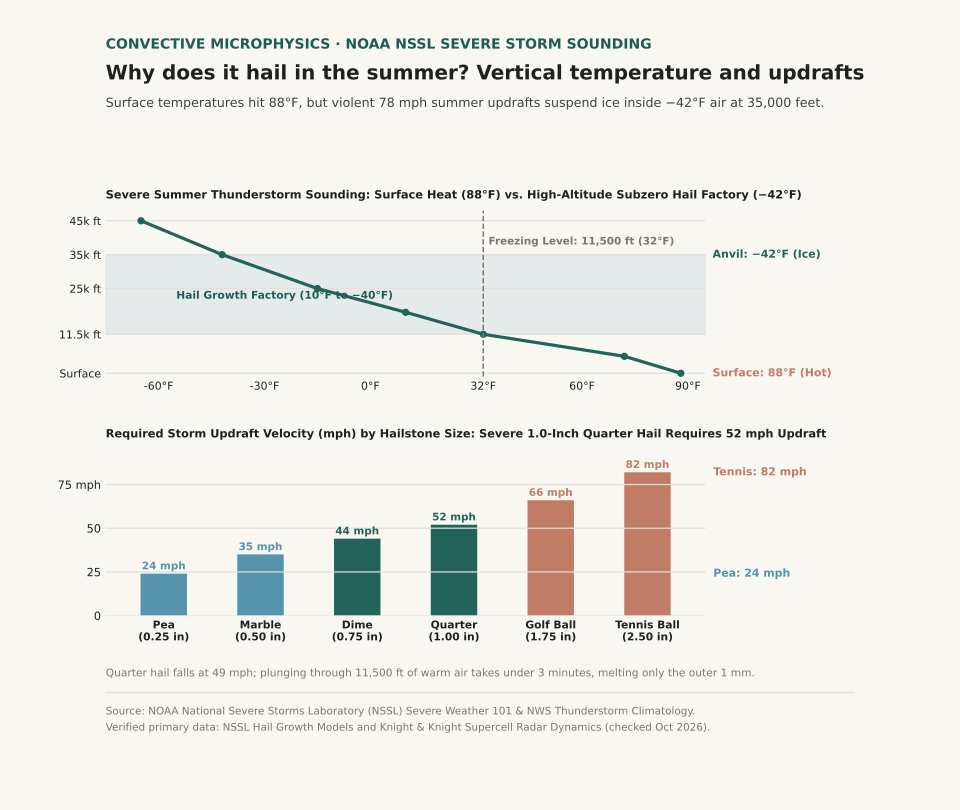
While the ground swelters at 88°F, the atmosphere cools rapidly with height at the environmental lapse rate. In summer, the freezing level (0°C / 32°F isotherm) typically sits between 11,000 and 14,000 feet above ground level. Above that boundary lies a deep column of sub-freezing air where moisture exists as supercooled liquid water droplets—water that remains liquid down to −40°F because it lacks a mineral nucleus to freeze upon.
When a tiny ice crystal or frozen raindrop embryo enters this zone, supercooled droplets freeze onto it on contact. As the thunderstorm's powerful updraft repeatedly suspends the embryo in this high-altitude "hail factory" (between 10°F and −40°F), the stone collects layer after layer of ice:
- Wet Growth: In warmer, moisture-dense cloud zones near freezing, water coats the stone and freezes slowly into clear, high-density ice rings.
- Dry Growth: In colder upper regions (−15°F to −40°F), droplets freeze instantly on impact, trapping microscopic air bubbles that form cloudy white rime rings.
A hailstone's concentric rings are not formed by bouncing up and down dozens of times; they form as the stone passes through varying liquid water concentrations within a single massive updraft plume.
Why Hail Doesn't Melt on the Way Down to Earth
If the ground is 88°F and the freezing level is 11,500 feet up, why doesn't the hailstone melt into ordinary rain before reaching the ground? The answer is terminal velocity and thermal mass.
| Hail Description | Diameter (in / mm) | Required Updraft Speed | Terminal Fall Velocity | Fall Time Through Warm Layer (11,500 ft) | Melting Loss During Fall |
|---|---|---|---|---|---|
| Pea Size | 0.25 in (6.4 mm) | 24 mph (10.7 m/s) | 18 mph (8.0 m/s) | ~7.2 minutes | 70% to 100% melts into cold rain |
| Marble Size | 0.50 in (12.7 mm) | 35 mph (15.6 m/s) | 28 mph (12.5 m/s) | ~4.6 minutes | 40% to 50% melts into slush |
| Quarter (Severe Criteria) | 1.00 in (25.4 mm) | 52 mph (23.2 m/s) | 49 mph (21.9 m/s) | ~2.6 minutes | Only outer 1–2 mm melts (~15% mass) |
| Golf Ball | 1.75 in (44.5 mm) | 66 mph (29.5 m/s) | 62 mph (27.7 m/s) | ~2.1 minutes | <10% melts; strikes ground with destructive force |
| Tennis Ball | 2.50 in (63.5 mm) | 82 mph (36.6 m/s) | 75 mph (33.5 m/s) | ~1.7 minutes | <5% melts; shatters windshields and roof tiles |
A one-inch quarter hailstone falls at nearly 50 miles per hour. Plunging through 11,500 feet of warm air takes just over two and a half minutes. That is far too brief for heat to conduct into the core of dense, solid ice (0.90 g/cm³); only a millimeter or two of the outer shell melts into water. Furthermore, as the stone falls through drier air under the cloud base, evaporative cooling chills the air immediately surrounding the stone, creating a protective sub-freezing envelope during descent.
Curious how summer thunderstorm frequencies and temperature departures compare across decades in your city? Open Eranorms in your browser or Download Eranorms for iPhone and Get Eranorms on Android to explore historical convective weather records, climate normals, and seasonal trends across thousands of weather stations.