
Why Is It Coldest Just After Sunrise? The Science of Dawn Lows
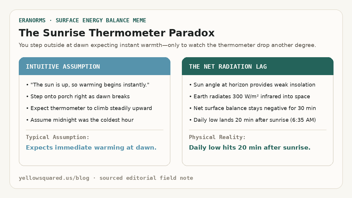
Anyone who walks their dog or runs at dawn has felt the sunrise chill: the moment the sun peeks over the horizon, the air often feels noticeably colder than it did in pitch black thirty minutes earlier. If you check an automated outdoor thermometer, the numbers confirm your senses: surface air temperatures regularly hit their absolute 24-hour minimum 15 to 30 minutes after sunrise. According to surface energy budget climatologies from the NOAA National Weather Service Automated Surface Observing System (ASOS), this temperature dip is not an illusion—it is a direct consequence of net radiative equilibrium.
Just because the sun is visible does not mean the Earth is gaining heat. Surface temperature is governed by the balance between incoming solar radiation and outgoing terrestrial radiation. Until the rising sun climbs high enough into the sky to deliver more energy than the ground emits into space, the ground continues to lose heat.
Sunrise is not the start of surface warming; it is the moment when the rate of nighttime cooling finally begins to decelerate.
The Surface Radiation Budget: Why Sunrise Doesn't Mean Warming
The thermal state of the Earth's surface layer is determined by the net radiation equation:
R_net = S_in - S_out + L_in - L_out
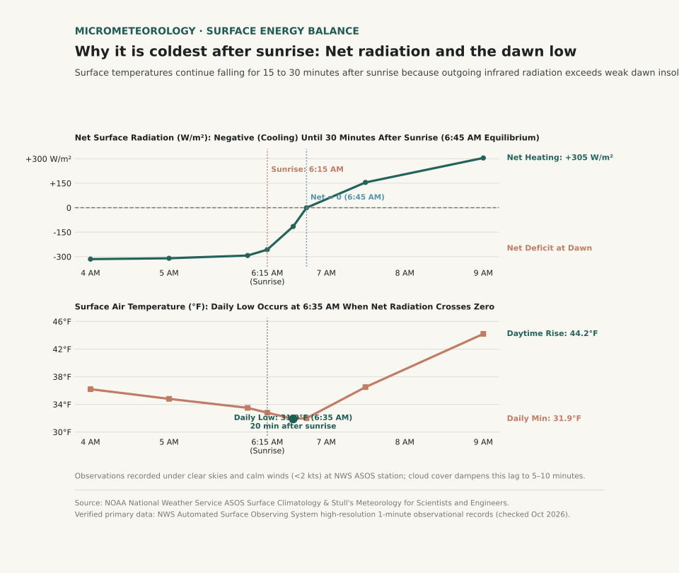
Throughout the night, incoming solar radiation (S_in) is zero. Meanwhile, the surface of the Earth continuously emits longwave infrared radiation (L_out) upward into the atmosphere at a rate of 300 to 350 Watts per square meter. Because outgoing infrared vastly exceeds the downward atmospheric counter-radiation (L_in), net radiation is negative, and the ground chills the thin boundary layer of air sitting directly above it.
At the exact instant of astronomical sunrise (solar elevation angle = 0°), the sun's rays strike the ground at a nearly horizontal, grazing angle. The solar beam must pass through a thick slice of atmosphere (air mass > 10), where dust, aerosols, and air molecules scatter away most of the direct sunlight. As a result, the solar insolation reaching the ground at sunrise is only 30 to 50 W/m²—far less than the 300 W/m² that the ground is simultaneously radiating away into space.
The 20-Minute Dawn Lag: When Net Radiation Reaches Zero
Because the ground is still losing six to ten times more energy than it receives from the early morning sun, the surface continues to cool. It is not until 15 to 30 minutes after sunrise—when the sun climbs to roughly 4° to 7° above the horizon—that incoming solar absorption finally equals outgoing terrestrial radiation (R_net = 0).
This zero-crossover point represents the exact moment of minimum surface temperature. Only after incoming sunlight exceeds outgoing infrared does net radiation turn positive, finally initiating daytime sensible heat flux and warming the morning air.
Think of the atmosphere like a leaking bathtub: turning on a trickle of water at sunrise won't raise the water level until the inflow exceeds the open drain.
How Wind and Clouds Alter the Timing of the Morning Low
The length of the post-sunrise temperature lag depends on atmospheric stability, moisture, and cloud cover:
| Atmospheric Condition | Nocturnal Inversion Strength | Outgoing Infrared Rate | Timing of Daily Low | Post-Sunrise Temperature Drop |
|---|---|---|---|---|
| Clear Sky & Calm Wind (<2 kts) | Strong surface radiation inversion | High (~300–320 W/m²) | 20 to 30 minutes after sunrise | Drops 1.0°F to 2.5°F after dawn |
| Dry Desert Basin | Extreme nocturnal ground cooling | Very High (>340 W/m²) | 25 to 35 minutes after sunrise | Drops 2.0°F to 4.0°F after dawn |
| Moderate Breeze (8–15 kts) | Mechanically mixed boundary layer | Moderate (continuous vertical mixing) | 0 to 10 minutes after sunrise | Negligible post-dawn drop (<0.5°F) |
| Overcast Stratus Cloud Deck | Weak or absent inversion | Low (clouds radiate IR back to ground) | At or slightly before sunrise | Zero post-dawn drop; steady dawn temp |
| Passing Cold Front at Dawn | Advective temperature plunge | Governed by air mass replacement | Mid-morning or afternoon | Continuous drop irrespective of sunlight |
What This Means for Gardeners, Runners, and Drivers
Understanding the post-sunrise temperature lag helps you avoid three common morning hazards:
- Frost Damage to Tender Plants: Gardeners who inspect their vegetable patches at 6:00 AM and see liquid dew may assume their tomatoes survived the night. However, if sunrise is at 6:15 AM, the true freezing low often arrives at 6:40 AM, flash-freezing leaves just as the morning light breaks. Keep frost covers on until 45 minutes after sunrise.
- Black Ice on Bridges and Overpasses: Road surfaces frequently hit freezing right as commuter traffic peaks. Road moisture that stayed liquid at 5:30 AM can glaze into transparent black ice between 6:30 and 7:00 AM under clear morning skies.
- Morning Layering for Runners: If you leave the house right at dawn, wear an extra wind-resistant layer; the sharpest chill of your workout will arrive twenty minutes into your run.
Curious how morning temperature departures and seasonal normals compare in your hometown? Open Eranorms in your browser or Download Eranorms for iPhone and Get Eranorms on Android to explore historical hourly observations, climate normals, and weather extremes across thousands of official weather stations.