
Why Is San Francisco Cold in July and Warmest in September? How Coastal Upwelling Drives Summer Fog
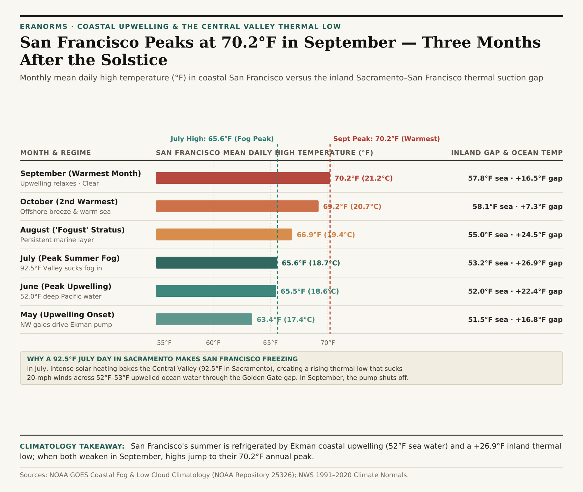
Every July, tourists step off flights at San Francisco International Airport wearing shorts and t-shirts — only to shiver in a 56°F (13.3°C) afternoon gale while a gray wall of stratus fog pours over Twin Peaks. Drive just 75 miles northeast up Interstate 80 to Sacramento on that exact same July afternoon, and the thermometer reads 92.5°F (33.6°C) under cloudless skies. Even stranger, San Francisco does not reach its warmest month of the year until September (70.2°F / 21.2°C mean high) and October (69.2°F / 20.7°C) — a full three months after the June summer solstice.
This dramatic seasonal lag is not random coastal weather; it is a coupled ocean-atmosphere heat engine analyzed in NOAA's GOES-Derived Coastal Fog and Low Cloud Climatology for Northern California and the California Energy Commission's Marine Layer & Coastal Stratus Assessment. To compare 30-year monthly temperature, wind, and fog curves between coastal microclimates and inland valleys, Compare coastal vs. inland climate norms in Eranorms.
Part 1: How Ekman Transport Wells Up 52°F Deep Pacific Water in June & July
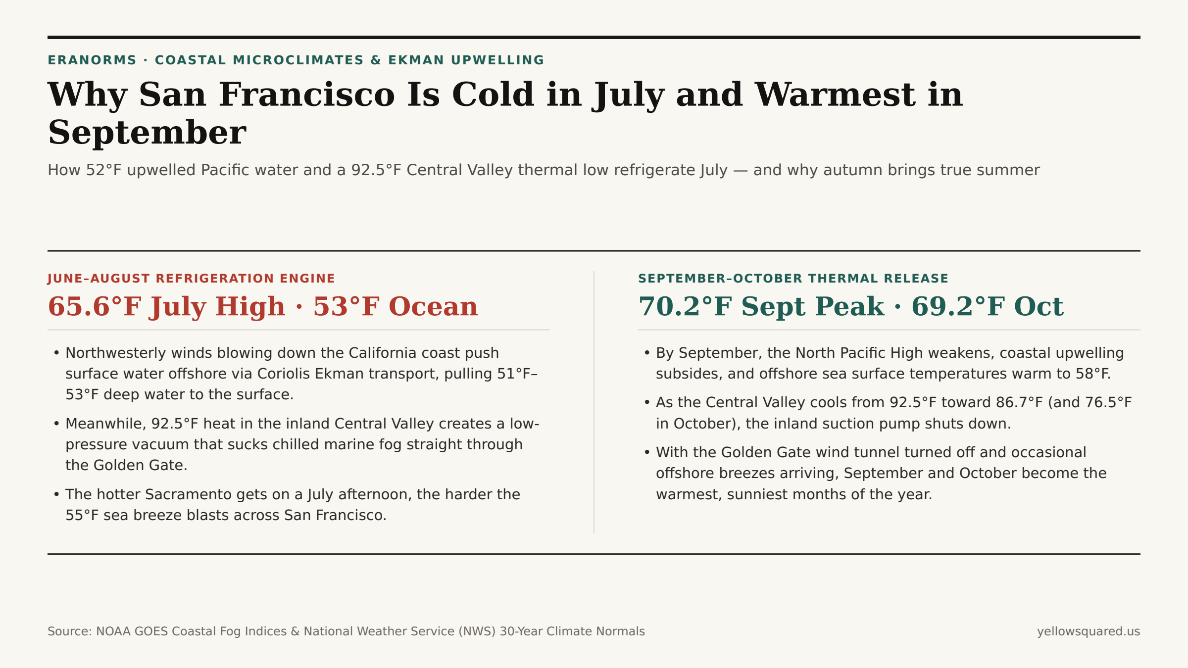
During late spring and summer (May through August), the semi-permanent North Pacific High strengthens off the California coast. Clockwise winds circulating around the eastern edge of that high-pressure dome blow briskly from the northwest parallel to the northern California coastline. Because of Earth's rotation (the Coriolis effect), wind blowing southward along a western continental margin does not push surface water straight south — it deflects the top 50 meters of ocean water 90 degrees to the right (westward, out to sea) in a process called Ekman transport.
To replace the warm surface water pushed offshore, frigid, nutrient-rich water from 100 to 200 meters deep rises to the surface right along the coast from Point Reyes to Monterey. As a result, offshore sea surface temperatures near the Golden Gate actually drop during late spring and summer, bottoming out at 51.5°F to 53.2°F (10.8°C to 11.8°C) in May, June, and July.
Part 2: The Central Valley Thermal Low & The Golden Gate Wind Tunnel
Cold ocean water alone creates a shallow layer of coastal advection fog (as moist Pacific air cools below its dew point over the 52°F water), but what pulls that fog bank miles inland across San Francisco every summer afternoon is the Central Valley Thermal Low:
- The Inland Suction Pump (+26.9°F Gap in July): Under intense June and July solar insolation, the interior Central Valley (from Redding and Sacramento down to Fresno and Bakersfield) heats to 90°F–100°F+. That superheated air expands and rises, creating a deep surface low-pressure trough across interior California.
- The Golden Gate Gap: The California Coast Ranges block dense, cool marine air from flowing inland almost everywhere — except at the sea-level break of the Golden Gate and San Francisco Bay. Every summer afternoon, the pressure gradient between the offshore North Pacific High and the inland Central Valley Low sucks a 15-to-25-mph river of 55°F fog straight through the Golden Gate, holding San Francisco's average July high to just 65.6°F (18.7°C).
"Paradoxically, the more intense a July heat wave becomes in Sacramento and Redding, the deeper the inland thermal low drops — and the harder the 54°F fog bank blasts into San Francisco."
Part 3: Why September (70.2°F) and October (69.2°F) Bring True Summer
By late August and September, the sun angle declines across the Northern Hemisphere and the North Pacific High migrates southward and weakens. Two things happen in tandem: northwest gales relax so coastal upwelling shuts down (allowing offshore Pacific water to warm to 57.8°F–58.1°F), and the Central Valley cools from 92.5°F in July to 86.7°F in September and 76.5°F in October, cutting the inland-to-coast suction gradient from +26.9°F down to +7.3°F. With the marine wind tunnel switched off — and occasional light offshore breezes descending and warming adiabatically from the interior — San Francisco enjoys its clearest skies and warmest afternoons of the year in September (70.2°F) and October (69.2°F).
| Month & Regime | SF Mean High | Sacramento High | Inland Temp Gap | Offshore Sea Temp | Coastal Stratus / Wind Regime |
|---|---|---|---|---|---|
| May (Upwelling Onset) | 63.4°F (17.4°C) | 80.2°F (26.8°C) | +16.8°F | 51.5°F (10.8°C) | NW winds initiate Ekman upwelling ("May Gray") |
| June (Peak Upwelling) | 65.5°F (18.6°C) | 87.9°F (31.1°C) | +22.4°F | 52.0°F (11.1°C) | Coldest coastal water & thick "June Gloom" |
| July (Peak Fog Suction) | 65.6°F (18.7°C) | 92.5°F (33.6°C) | +26.9°F (Peak) | 53.2°F (11.8°C) | Peak Central Valley low sucks 20-mph afternoon fog |
| August ("Fogust" Layer) | 66.9°F (19.4°C) | 91.4°F (33.0°C) | +24.5°F | 55.0°F (12.8°C) | Persistent afternoon stratus through Golden Gate |
| September (Annual Peak) | 70.2°F (21.2°C) | 86.7°F (30.4°C) | +16.5°F | 57.8°F (14.3°C) | Upwelling relaxes; clearest & warmest month in SF |
| October (2nd Warmest) | 69.2°F (20.7°C) | 76.5°F (24.7°C) | +7.3°F | 58.1°F (14.5°C) | Minimal pressure gradient; warm offshore breezes |
Exploring Coastal vs. Inland Seasonal Lags
Before packing for a trip to coastal California, Oregon, or Chile — where cold eastern-boundary ocean currents delay peak warmth into autumn — Compare coastal vs. inland climate norms in Eranorms to inspect month-by-month temperature, wind, and cloud cover profiles, and download the San Francisco upwelling and seasonal lag CSV dataset.