
Why Is San Francisco Colder in July Than in October? The Physics of California's Summer Fog Machine
Why Is San Francisco Colder in July Than in October? The Physics of California's Summer Fog Machine
Every July, thousands of visitors step off planes at SFO wearing shorts and t-shirts—and within two hours are standing in a Fisherman's Wharf gift shop buying an emergency fleece jacket as 25 mph gusts of 56°F (13°C) fog howl off the bay. Even though the famous quip "The coldest winter I ever spent was a summer in San Francisco" is an apocryphal misattribution that Mark Twain never actually wrote, the meteorological anomaly behind it is completely real: according to NOAA National Weather Service Bay Area records and U.S. climate normals, San Francisco is significantly colder in July (66.3°F downtown average high; 59°F at Ocean Beach) than in September (70.2°F) or October (69.3°F).
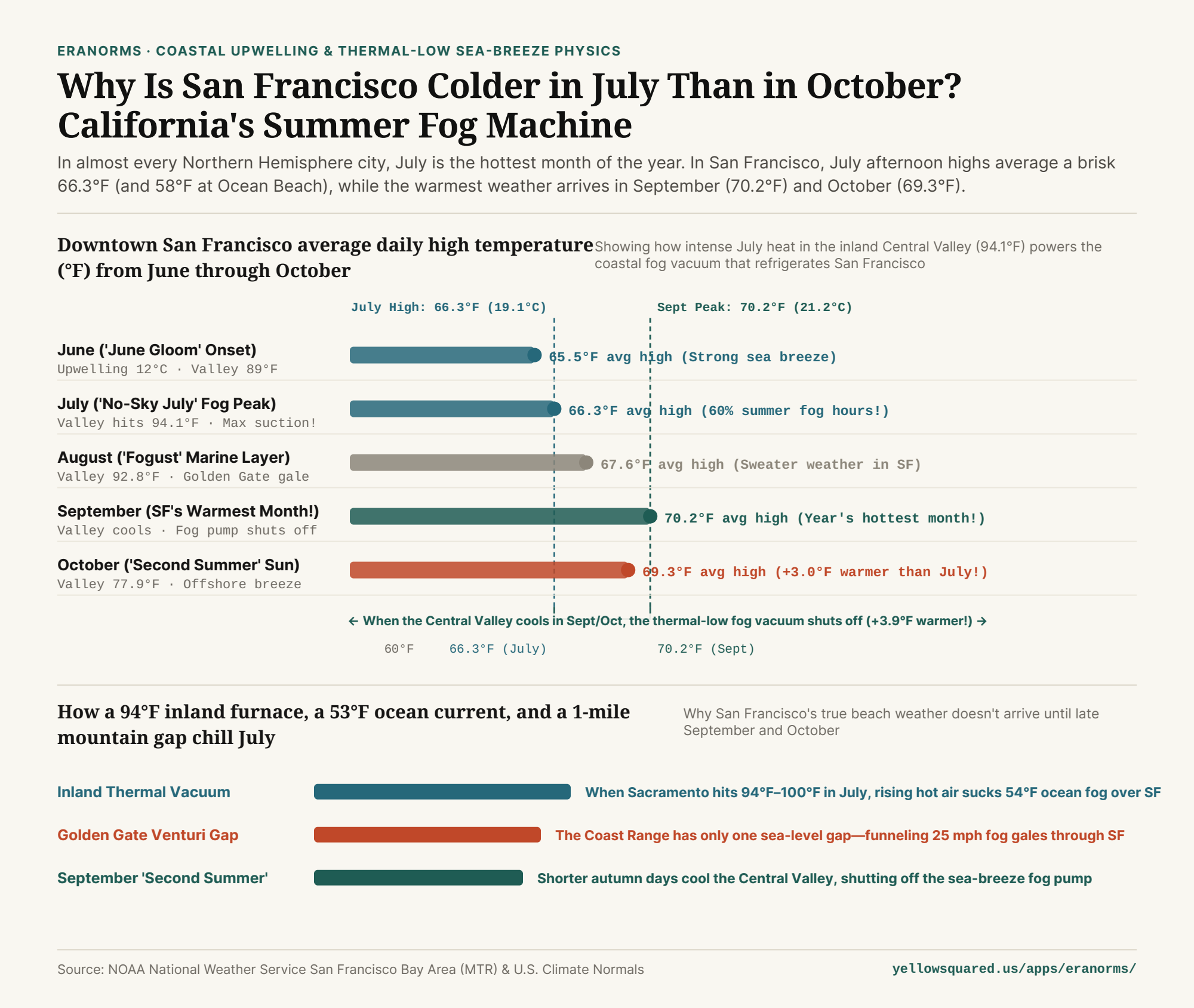
1. Paradoxical Thermodynamics: The Hotter Inland California Gets, the Colder SF Gets
Why does San Francisco refrigerate itself right at the height of astronomical summer? The answer is a three-part thermodynamic engine linking the Pacific Ocean, the Coast Ranges, and California's Central Valley:
- The 53°F Coastal Upwelling Freezer: In late spring and summer, clockwise winds around the North Pacific High blow southward along the California coast, pushing surface water offshore via Ekman transport and drawing icy deep water (
11°C–13°C / 52°F–55°F) to the surface. When moist Pacific air passes over that cold water bezel, its water vapor condenses into a thick deck of advection fog. - The 95°F Central Valley Thermal Vacuum: Eighty miles inland, the sun bakes Sacramento, Redding, and Fresno to
94°F–102°F (34°C–39°C). That scorching inland air expands and rises, creating a deep low-pressure trough known as a thermal low. - The Golden Gate Venturi Funnel: Dense, high-pressure marine air offshore rushes inland to fill the rising Central Valley vacuum. Because the coastal mountains block the marine layer everywhere except the sea-level gap of the Golden Gate (and the San Bruno gap near SFO), a river of
55°Ffog blasts directly across San Francisco every July afternoon at20 to 28 mph.
"San Francisco's summer air conditioner is powered by Sacramento's furnace: the hotter the Central Valley bakes in July, the harder it sucks 54°F ocean fog through the Golden Gate."
2. Why September and October Are San Francisco's True Summer
Once September and October arrive, days grow shorter and the sun's angle drops. As a result, California's inland Central Valley cools down from 94.1°F (July) to 87.9°F (September) and 77.9°F (October).
As the inland furnace cools, the thermal low weakens and the pressure gradient between the ocean and the interior collapses. The afternoon fog pump shuts off, the stratus deck retreats offshore, and occasional light offshore winds warm adiabatically as they descend the coastal hills—giving San Francisco its warmest, sunniest beach days of the year in late September (`70.2°F` mean high) and October (`69.3°F` mean high).
3. San Francisco vs. Inland Central Valley Monthly Normals Table
Compare Downtown San Francisco highs, Sacramento inland highs, and Golden Gate sea-breeze intensity from May through October below (available in why-is-san-francisco-so-cold-in-july-mark-twain-summer-fog.csv):
| Month | Downtown SF High | Sacramento Inland High | Inland-Coast Temp Gap | Golden Gate Afternoon Wind | Microclimate Regime |
|---|---|---|---|---|---|
| May | 63.8°F (17.7°C) | 83.5°F (28.6°C) | 19.7°F gradient | 18–22 mph westerly | Peak cold upwelling onset |
| July ('No-Sky July') | 66.3°F (19.1°C) | 94.1°F (34.5°C) | 27.8°F max suction! | 22–28 mph + 60% fog | Peak thermal-low fog pump! |
| August ('Fogust') | 67.6°F (19.8°C) | 92.8°F (33.8°C) | 25.2°F gradient | 20–25 mph stratus | Persistent coastal marine layer |
| September (Warmest!) | 70.2°F (21.2°C) | 87.9°F (31.1°C) | 17.7°F (Weakening) | 10–14 mph light breeze | Peak 'Indian Summer' sun! |
| October ('Second Summer') | 69.3°F (20.7°C) | 77.9°F (25.5°C) | 8.6°F (Pump off!) | 8–12 mph calm sun | +3.0°F warmer than July! |
4. Compare Coastal vs. Inland Climate Curves in Eranorms
Even within San Francisco itself, mountain gaps create dramatic street-by-street microclimates: on a July afternoon when Ocean Beach in the Outer Sunset sits in 57°F fog, Mission Dolores—shielded behind the 925-foot Twin Peaks ridge—regularly basks in 68°F–72°F sunshine just four miles east. To compare month-by-month temperature, wind, and sunshine normals across coastal and inland weather stations, Compare historical climate normals in Eranorms.
Verified Primary Sources
- NOAA National Weather Service — San Francisco Bay Area (MTR) Climate Records & Marine Layer Sea-Breeze Dynamics (Retrieved 2026-10-31).
- Wikipedia / NOAA NCEI Normals — Climate of the United States: Coastal California Summer Upwelling, Advection Fog & September Temperature Maximum (Retrieved 2026-10-31).