
Why Doesn't It Rain on the US West Coast in the Summer Compared to the East Coast?
Why Doesn't It Rain on the US West Coast in the Summer Compared to the East Coast?
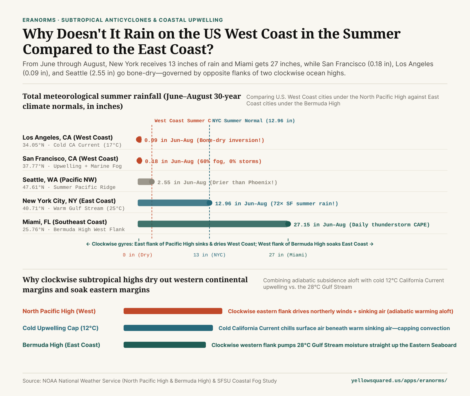
Visitors flying from New York, Atlanta, or Chicago to California or the Pacific Northwest in July are often stunned by two things: nobody carries an umbrella, and there is zero thunder or lightning all summer long. Between June 1 and August 31, New York City averages 12.96 inches of rain and Miami receives 27.15 inches, whereas San Francisco records just 0.18 inches, Los Angeles gets 0.09 inches, and even famously rainy Seattle receives only 2.55 inches. Both coastlines sit beside an ocean at the exact same latitudes—so why is one bone-dry all summer while the other is drenched in tropical thunderstorms?
1. Opposite Sides of Two Clockwise Subtropical Highs
In the Northern Hemisphere, semi-permanent subtropical high-pressure systems spin clockwise due to the Coriolis effect. As defined in the NOAA National Weather Service Meteorology Glossary for the North Pacific High and the Bermuda/Azores High, both oceans are dominated by a massive summer high-pressure dome—but the two U.S. coastlines sit on opposite flanks of that clockwise rotation:
- The U.S. West Coast sits on the Eastern Flank of the North Pacific High: Clockwise flow along the eastern edge of the North Pacific High drives persistent northerly winds from Canada southward down the Washington, Oregon, and California coast, while large-scale air aloft sinks toward the surface (subsidence) and warms adiabatically by compression.
- The U.S. East Coast sits on the Western Flank of the Bermuda High: Clockwise flow along the western edge of the Bermuda High pumps warm, humid tropical air from the Caribbean and Gulf of Mexico northward up the Eastern Seaboard.
"Every raindrop begins with rising air. On the West Coast, cold 12°C ocean water at the bottom and warm sinking air at the top create an upside-down temperature profile that physically locks summer clouds below 2,000 feet."
2. Cold California Upwelling vs. the 28°C Gulf Stream
Ocean currents amplify this atmospheric split. Along the West Coast, northerly winds pushing southward combine with Earth's rotation (Ekman transport) to push surface water offshore, drawing icy deep-ocean water (12°C–14°C / 53°F–57°F) up to the surface inside the California Current. As shown in San Francisco State University coastal micrometeorology research, while low coastal fog (Advection fog) covers coastal California 60% of summer hours, that cold marine layer is capped at 400–800 meters by hot, sinking air above it.
Because cold, dense air is already at the bottom and warm, buoyant air is already at the top, the atmosphere is statically stable: air parcels cannot rise to form towering cumulonimbus rain clouds. On the East Coast, the Gulf Stream bathes the coastline in 25°C–29°C (77°F–85°F) water, supercharging surface air with heat and water vapor that erupts into afternoon thunderstorms whenever a weak front or sea-breeze boundary passes through.
3. East Coast vs. West Coast Summer Climate Normals Table
Compare summer rainfall, offshore sea-surface temperatures, and governing pressure systems across five U.S. coastal cities below (available in why-is-the-west-coast-of-the-us-drier-in-summer-than-the-east-coast.csv):
| U.S. Coastal City | Latitude | Summer Pressure System | Offshore Current & SST | June–August Rainfall | Atmospheric Stability Mechanism |
|---|---|---|---|---|---|
| Los Angeles, CA (West) | 34.05° N | North Pacific High (East Flank) | California Current (17°C) | 0.09 in (2.3 mm) | Strong subsidence inversion cap |
| San Francisco, CA (West) | 37.77° N | North Pacific High (East Flank) | Coastal Upwelling (12°C) | 0.18 in (4.6 mm) | Marine fog capped below 600m |
| Seattle, WA (West) | 47.61° N | North Pacific Summer Ridge | California Current (13°C) | 2.55 in (64.8 mm) | Ridge deflects storm track to Alaska |
| New York City, NY (East) | 40.71° N | Bermuda High (West Flank) | Gulf Stream (25°C) | 12.96 in (329 mm) | Humid southerly flow + fronts |
| Miami, FL (East) | 25.76° N | Bermuda High + Sea Breeze | Gulf Stream (29°C) | 27.15 in (690 mm) | Extreme CAPE + daily storms |
4. Explore Month-by-Month Precipitation and Dew Point Normals in Eranorms
Wait until November, and the entire pattern flips: the North Pacific High retreats southward toward Hawaii, allowing the Aleutian Low and Pacific atmospheric rivers to drench Seattle and San Francisco all winter long. To compare 30-year monthly rainfall, dew point, and solar radiation curves across global weather stations, Compare historical climate normals in Eranorms.
Verified Primary Sources
- NOAA National Weather Service — Meteorology Glossary: North Pacific High & Seasonal Migration and Bermuda/Azores High (Retrieved 2026-10-31).
- Oliphant, Baguskas & Fernandez (2021, SFSU / Theoretical and Applied Climatology) — Impacts of Low Cloud and Fog on Surface Radiation Fluxes for Coastal California (Retrieved 2026-10-31).