
Why Is the West Coast Milder Than the East Coast at the Same Latitude? Maritime vs. Continental Climate Explained
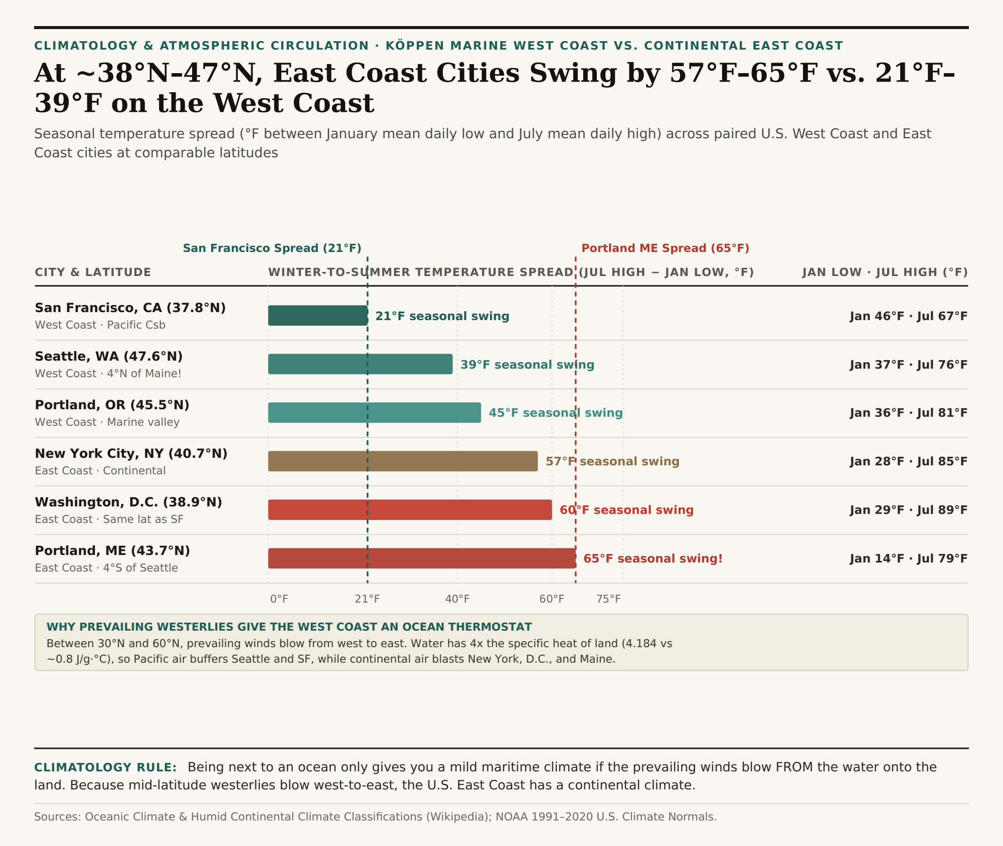
Find Seattle, Washington (47.6°N) on a globe and trace your finger due east to the Atlantic coast: Seattle actually sits four degrees further north than Portland, Maine (43.7°N), five degrees north of Boston (42.4°N), and seven degrees north of New York City (40.7°N). Yet in January, Seattle's average overnight low is a mild 37°F (3°C) while Portland, Maine plunges to 14°F (-10°C). Travel south to ~38°N latitude in July, and San Francisco (37.8°N) enjoys a crisp 67°F (19°C) afternoon high while Washington, D.C. (38.9°N) bakes at 89°F (32°C).
Why does the U.S. West Coast enjoy mild winters and cool summers while the U.S. East Coast — which is also sitting right next to a massive ocean! — experiences freezing continental winters and sweltering summers? As detailed in Wikipedia's Climatological Reference on Oceanic / Marine West Coast Climates (Cfb/Csb), Humid Continental Climate Dynamics (Dfa/Dfb), and the Climate of the United States, the secret is which direction the prevailing winds blow across the mid-latitudes. To compare 30-year monthly temperature and precipitation normals across any pair of coastal or inland cities, Compare West Coast and East Coast climate normals in Eranorms.
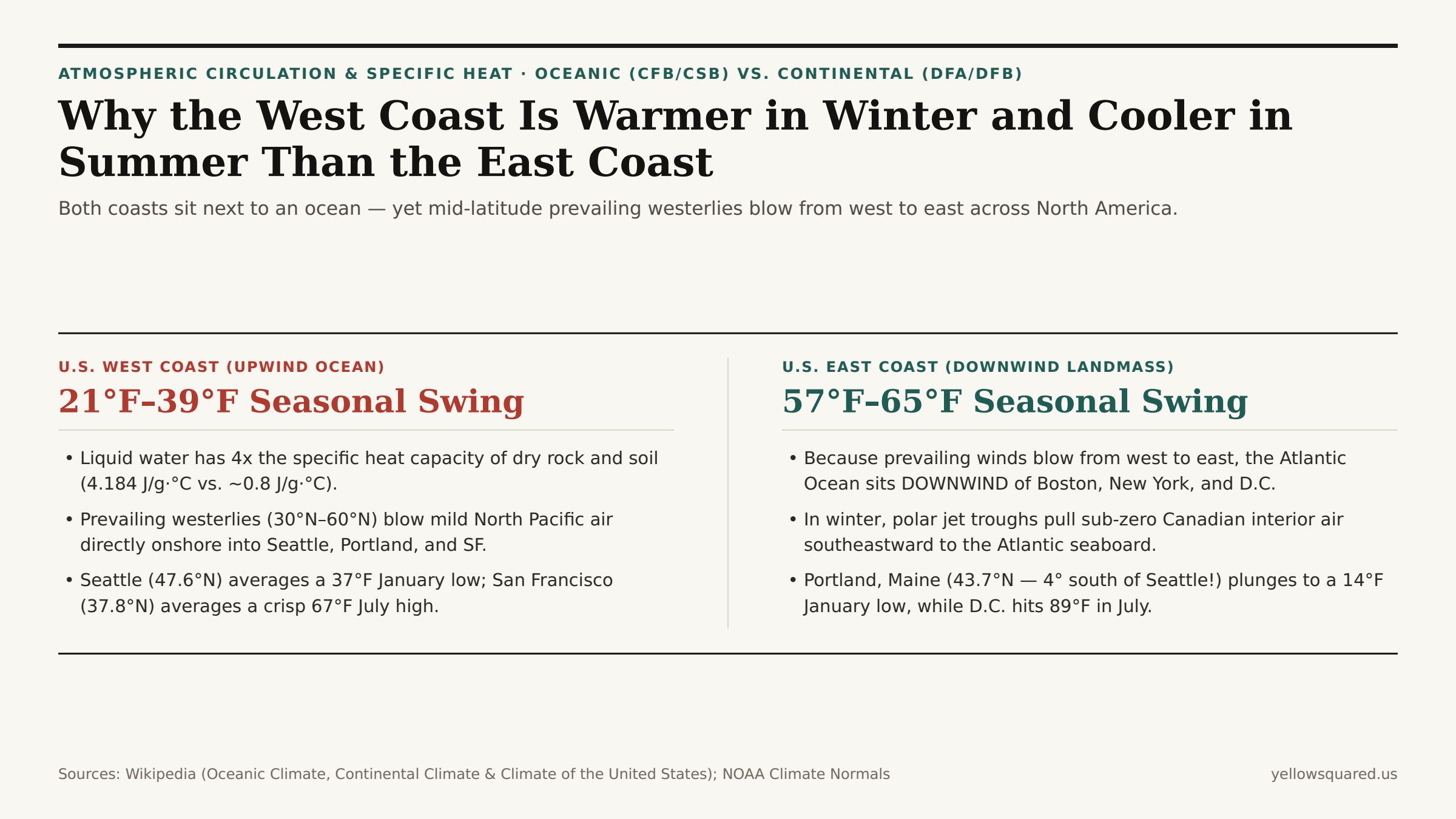
1. Specific Heat Capacity (4.184 J/g·°C) + The Prevailing Westerlies (30°N–60°N)
Two laws of physics explain why western continental margins (Seattle, San Francisco, London, Paris, Vancouver) have radically narrower annual temperature swings than eastern continental margins (Boston, New York, Washington D.C., Vladivostok, Beijing) at the exact same latitude:
- Water Has 4x to 5x the Specific Heat Capacity of Land: Liquid water requires
4.184 joulesof energy to raise 1 gram by1°C, whereas dry continental rock, soil, and sand require only~0.8 to 0.9 J/g·°C. Furthermore, solar radiation penetrates tens of meters into a churning, transparent ocean mixed layer (and evaporates water as latent heat), whereas sunlight only heats the top few centimeters of opaque soil. As a result, the North American interior heats up like a cast-iron skillet in July and radiates heat away into a deep freeze in January, while the North Pacific Ocean off California and Washington stays inside a narrow48°F to 60°F (9°C–16°C)band all year long. - Prevailing Westerlies Blow From West to East (
30°N–60°N): Because of Earth's Ferrel cell circulation and Coriolis deflection, surface winds across the mid-latitudes (30°N to 60°N) blow predominantly from west to east. That means air arriving in Seattle, Portland (OR), and San Francisco has spent the previous 3,000 miles equilibrating over the temperature-controlled Pacific Ocean (Oceanic Climate). Conversely, air arriving in New York, Boston, and Washington, D.C. has spent the previous 2,500 miles travelling across the blistering-hot or sub-zero landmass of continental North America (Humid Continental Climate)!
2. California Current Upwelling (52°F) vs. The Warm Gulf Stream (80°F)
Ocean gyre currents reinforce the wind asymmetry in summer (Climate of the United States). Because North Pacific gyre winds blow southward along the California and Oregon coast, Ekman transport pushes surface water offshore and draws frigid, nutrient-rich deep water (50°F–55°F / 10°C–13°C) up to the surface along the California Current. When warm summer air passes over that cold coastal upwelling strip and blows into Golden Gate, it condenses into San Francisco's famous summer fog and caps July highs at 67°F.
Along the U.S. East Coast, the Gulf Stream carries tropical 78°F–84°F (26°C–29°C) water northward from the Caribbean along the Southeast and Mid-Atlantic coast. In summer, when the Bermuda High pumps southerly air off the Gulf of Mexico and Gulf Stream into Washington, D.C., Baltimore, and New York, high heat combines with 70°F+ dew points; in winter, northwesterly cold fronts push the marine air offshore and plunge the East Coast into Arctic air.
"Mark Twain famously (if apocryphally) quipped that the coldest winter he ever spent was a summer in San Francisco: at 37.8°N, cold California Current upwelling and onshore Pacific westerlies keep San Francisco's July high (67°F) just 21°F above its January low (46°F)."
| City & Coast | Latitude | Köppen Class | Jan Mean Low | Jul Mean High | Seasonal Spread |
|---|---|---|---|---|---|
| San Francisco, CA (West) | 37.77°N | Csb (Marine Med.) |
46°F (8°C) | 67°F (19°C) | 21°F (Ultra-mild) |
| Seattle, WA (West) | 47.61°N | Csb / Cfb (Oceanic) |
37°F (3°C) | 76°F (24°C) | 39°F (Marine buffer) |
| Portland, OR (West) | 45.52°N | Csb (Marine Valley) |
36°F (2°C) | 81°F (27°C) | 45°F (Mild winter) |
| New York City, NY (East) | 40.71°N | Cfa / Dfa (East Coast) |
28°F (-2°C) | 85°F (29°C) | 57°F (Continental swing) |
| Washington, D.C. (East) | 38.91°N | Cfa (Subtropical) |
29°F (-2°C) | 89°F (32°C) | 60°F (+39°F wider than SF!) |
| Portland, ME (East) | 43.66°N | Dfb (Continental) |
14°F (-10°C) | 79°F (26°C) | 65°F (23°F colder Jan than SEA) |
Exploring Historical Temperature & Dew Point Normals
Whether you are comparing relocation cities, planning seasonal travel wardrobes, or checking why Western Europe (London at 51.5°N) mirrors Seattle (47.6°N) while Northeast Asia (Harbin and Vladivostok) mirrors New England, latitude is only half the climate equation. Compare West Coast and East Coast climate normals in Eranorms across all 12 months, and download the West Coast vs. East Coast latitude climate CSV dataset.