
Why Is There a 3.5-Hour Time Jump at the Afghanistan–China Border—The Largest Land Border Time Difference on Earth?
Normally, crossing an international land border changes your watch by at most one hour—or not at all. Even if you drive across the 18th-century meridian mismatch between Spain (UTC+01:00) and Portugal (UTC+00:00), or cross the Arctic frontier from Norway (UTC+01:00) into Russia's Murmansk Oblast (UTC+03:00) in winter, the jump is only one or two hours. Yet high in the Pamir and Hindu Kush mountains of Central Asia sits a 92-kilometer (57-mile) frontier where a single stride across the border watershed advances official civil time by 3 hours and 30 minutes. As documented in the geographic and treaty records of Wakhjir Pass and the Afghanistan–China border, stepping from the eastern tip of Afghanistan's Wakhan Corridor (UTC+04:30) into China's Xinjiang Uygur Autonomous Region (UTC+08:00) produces the sharpest terrestrial time-zone jump anywhere on Earth.
How did Afghanistan and China end up sharing a 57-mile border in 1895, what is the true solar time at 74°29'E longitude on the crest of the 4,923-meter (16,152-foot) Wakhjir Pass, and why do China's borders hold the top four terrestrial clock-jump records in the world? Here is the complete geodesy and border history.
1. The 1895 Wakhan Corridor & The 1963 Sino-Afghan Boundary Treaty
Look at a map of northeastern Afghanistan, and you will see a narrow panhandle of land—just 16 to 64 kilometers wide and 350 kilometers long—stretching eastward between Tajikistan to the north and Pakistan to the south until it dead-ends into China. Known as the Wakhan Corridor, this high-altitude valley was created in 1895 during the "Great Game" by an Anglo-Russian boundary commission so that the Russian Empire (in modern Tajikistan) and the British Indian Empire (in modern Pakistan) would never touch directly (Wikipedia — Afghanistan–China border).
On November 22, 1963, the Kingdom of Afghanistan and the People's Republic of China signed the formal Boundary Treaty demarcating their 92-kilometer (57-mile) frontier along the Mustagh Range watershed from the Pakistan tripoint at 5,630 meters to the Tajikistan tripoint on Povalo-Shveikovskogo / Kokrash Kol Peak at 5,698 meters. The only potentially navigable route across that glaciated wall is the ancient Silk Road saddle of Wakhjir Pass (4,923 m / 16,152 ft), connecting Wakhan District in Afghanistan's Badakhshan Province with Taxkorgan Tajik Autonomous County in Kashgar Prefecture, Xinjiang.
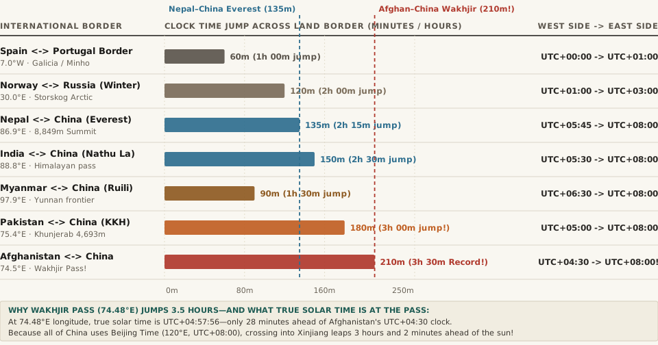
2. The Solar Longitude Math at 74.48°E: Why China's Clock Is 3 Hours Ahead of the Sun
Why do the clocks on opposite sides of Wakhjir Pass disagree by 3 hours and 30 minutes (210 minutes)? Let's compare both countries' legal time zones against the actual position of the Sun at the pass's coordinates (37.0872°N, 74.4842°E, per Wikipedia's Wakhjir Pass survey):
- True Local Mean Solar Time at Wakhjir Pass (
UTC+04:57:56): Because Earth rotates1°every4 minutes(15°per hour), a meridian at74.4842°Esits74.4842 × 4 = 297.94 minutes—or 4 hours, 57 minutes, and 56 seconds—ahead of Greenwich (UTC+00:00). - The Afghan Side (
Asia/Kabul,UTC+04:30): Afghanistan observes a nationwide half-hour offset ofUTC+04:30year-round (centered on67.5°Enear Kabul at69.2°E). At Wakhjir Pass on the far eastern tip of the country,UTC+04:30sits within just 27 minutes and 56 seconds of true solar noon. - The Chinese Side (
Asia/Shanghai,UTC+08:00): Although China spans more than 60 degrees of longitude—and used five separate time zones (UTC+05:30Kunlun Time throughUTC+08:30Changbai Time) between 1918 and 1949—since 1949 the entire People's Republic of China has mandated a single official national standard time: Beijing Time (UTC+08:00), anchored to the120°Emeridian near the Yellow Sea coast,45.5°of longitude (nearly 4,000 kilometers) east of Wakhjir Pass! - The 3.5-Hour Discontinuity & Unofficial Xinjiang Time (
UTC+06:00): Because official Chinese time (UTC+08:00) sits 3 hours and 2 minutes ahead of the sun at Wakhjir Pass, stepping from the Afghan cairn at9:00 AMinstantly advances official civil time to12:30 PMon the Chinese side. In daily life across Kashgar and Taxkorgan, many local Uyghur and Tajik residents informally observe Xinjiang Time (UTC+06:00)—or shift their Beijing-Time work and school schedules two hours later (10:00 AMto7:00 PM) so solar noon aligns with lunch.
"With a difference of 3.5 hours, the Afghanistan–China border has the sharpest official change of clocks of any international frontier (UTC+04:30 in Afghanistan to UTC+08:00, in China)."
3. Complete Data Table: The World's Largest Land-Border Time Jumps
Because China locks a continent-sized landmass to a single eastern meridian (UTC+08:00), its western and southern frontiers account for the top five land-border clock jumps on Earth. The reproducible table below—matching the companion CSV (afghanistan-china-wakhjir-pass-3-5-hour-border-and-global-land-time-jumps.csv)—ranks the steepest terrestrial time-zone boundaries worldwide:
| International Land Border | Western / Earlier Side | Eastern / Later Side | Crossing Longitude | Time Jump (Min) | Time Jump (Hr) | Border Crossing & Solar Note |
|---|---|---|---|---|---|---|
| Afghanistan ↔ China (Wakhjir Pass) | Afghanistan (UTC+04:30) |
China (UTC+08:00) |
74.48°E (4,923 m) |
210 min |
3h 30m (Record) |
92-km Wakhan frontier; sharpest land clock jump on Earth |
| Pakistan ↔ China (Khunjerab Pass) | Pakistan (UTC+05:00) |
China (UTC+08:00) |
75.43°E (4,693 m) |
180 min |
3h 00m |
Highest paved international border crossing (Karakoram Hwy) |
| Tajikistan / Kyrgyzstan ↔ China | Tajikistan (UTC+05:00) / KG (+06) |
China (UTC+08:00) |
73.6°E–78.0°E |
180 / 120 min |
3h 00m / 2h 00m |
Kulma Pass (+05 to +08 = 3h) & Torugart Pass (+06 to +08 = 2h) |
| India ↔ China (Nathu La / LAC) | India (UTC+05:30) |
China (UTC+08:00) |
78.0°E–97.0°E |
150 min |
2h 30m |
Two single-time-zone nations meeting across the Himalayas |
| Nepal ↔ China (Mount Everest) | Nepal (UTC+05:45) |
China (UTC+08:00) |
86.93°E (8,849 m) |
135 min |
2h 15m |
Stepping across the summit ridge of Mt. Everest jumps 2h 15m |
| Norway ↔ Russia (Storskog, Winter) | Norway (UTC+01:00 CET) |
Russia Murmansk (UTC+03:00) |
30.00°E |
120 min |
2h 00m (1h DST) |
Europe's steepest land border clock jump during winter |
| Myanmar ↔ China (Ruili / Muse) | Myanmar (UTC+06:30) |
China (UTC+08:00) |
97.85°E |
90 min |
1h 30m |
Half-hour Myanmar time meeting Beijing Time in Yunnan |
Whenever you need to compare half-hour offsets like Kabul (UTC+04:30), Delhi (UTC+05:30), and Kathmandu (UTC+05:45) against Beijing Time (UTC+08:00) or Western capitals, Open Tempo in your browser to visualize the exact solar and civil offset across every time zone.