
Why Are West Coast Ocean Beaches So Much Colder Than East Coast Beaches at the Exact Same Latitude?
Draw a horizontal line straight across the map of the United States along the 37°N to 38°N parallel of latitude. On the Atlantic coast sits Virginia Beach, Virginia (36.9°N) and Ocean City, Maryland (38.3°N), where August ocean swimmers wade into bath-warm surf averaging 75°F to 79°F (24°C–26°C) in boardshorts. Follow that exact same line of latitude to the Pacific coast at Santa Cruz and San Francisco, California (37.8°N), and the August ocean is a numbing 52°F to 58°F (11°C–14°C)—requiring a 4/3 mm neoprene wetsuit just to stay in the water for half an hour! Why are West Coast ocean beaches 20°F colder than East Coast beaches that receive the exact same angle of summer sunlight? As explained by NOAA JetStream's physical oceanography reference, SFBayWeather's analysis of NOAA coastal buoy normals, Science of Surfing's boundary-current breakdown, and the Fleet Science Center, the 20°F temperature gap is driven by two planetary fluid-dynamics engines working together: Clockwise Subtropical Ocean Gyres and Coastal Ekman Upwelling.
1. Reason 1 — Clockwise Ocean Gyres: Why the West Coast Gets Alaska Water and the East Coast Gets Caribbean Water
In the Northern Hemisphere, trade winds blowing west near the tropics and prevailing westerlies blowing east across the mid-latitudes—deflected to the right by Earth's rotation (the Coriolis effect)—force both the North Pacific Ocean and the North Atlantic Ocean to spin in giant clockwise loops called subtropical gyres (Fleet Science Center; FAU / NASA Ocean Currents):
- The East Coast Rides the Warm Western Boundary of the Atlantic Gyre (The Gulf Stream): Because the North Atlantic gyre spins clockwise, its western side (running along the East Coast of the United States) flows from south to north—pumping sun-baked tropical water directly out of the Caribbean Sea and Florida Straits up past the Carolinas, Virginia, and Maryland. Furthermore, due to how the Coriolis parameter varies with latitude (western boundary intensification), western boundary currents like the Gulf Stream (and Japan's Kuroshio Current in the Pacific) are narrow, deep, and fast-moving jets of warm water (Science of Surfing).
- The West Coast Rides the Cold Eastern Boundary of the Pacific Gyre (The California Current): On the eastern side of the clockwise North Pacific gyre (running along the West Coast of North America), the current flows in the opposite direction—from north to south. The California Current is a broad, slow, shallow drift carrying subarctic water down from the Gulf of Alaska and Oregon all the way to Baja California (SFBayWeather).
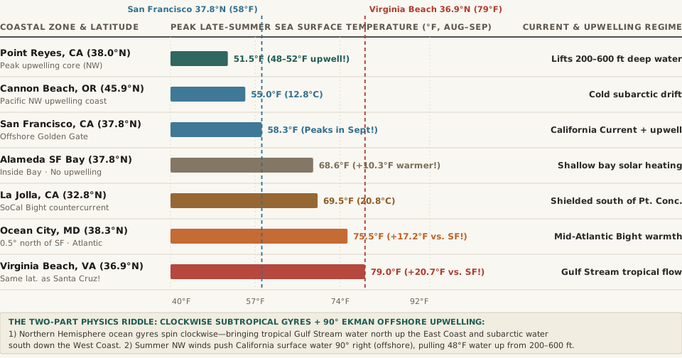
°F) across U.S. West Coast and East Coast locations near 37°N–38°N latitude (SFBayWeather / NOAA Normals; Science of Surfing).2. Reason 2 — Coastal Ekman Upwelling: Why Summer Winds Refrigerate California's Surf
If the California Current were the only factor, the top few meters of coastal water off California would still warm up into the mid-60s°F under strong June, July, and August sunshine—just as the shallow water inside San Francisco Bay warms to an average of 68.6°F at Alameda in August (SFBayWeather / NOAA). Yet outside the Golden Gate at Ocean Beach and Point Reyes, the ocean barely warms by 5°F between May and August, and often drops to a bone-chilling 48°F to 52°F in the middle of July!
The culprit is a rotational fluid mechanism discovered in 1905 by Swedish oceanographer Vagn Walfrid Ekman (SFBayWeather Ekman calculation):
- Northwest Winds Blowing Parallel to the Coast: All spring and summer, the semi-permanent North Pacific High pressure system spins clockwise offshore while California's Central Valley heats up, driving steady 15 to 25 mph north-northwest winds southward along the Oregon and California coastline.
- Ekman Transport Turns the Surface Layer
90°to the Right (Out to Sea): Because Earth rotates underneath the moving water, friction plus the Coriolis force causes the net wind-driven surface layer (the Ekman layer) to move at a90°right angle to the wind direction. When a wind blows south down the California coast,90°to the right points due west—straight out to sea! - Deep
48°FWater Rises 25 Feet Per Day from200–600 FeetDown: As SFBayWeather demonstrates, a steady22 mphnorthwest wind off San Francisco pushes roughly1.7 cubic metersof sun-warmed surface water offshore every second per meter of coastline. To fill the void left along the beach, frigid, nutrient-rich water from200 to 600 feet(60–180 meters) below the surface wells upward at roughly25 feet per day—reaching the surf zone in a week and resetting the coastal water temperature to48°F–54°Fall summer long!
"Upwelling happens when northwest winds push surface water offshore and cold water from 200 to 600 feet down rises to replace it, sometimes cooling the surface to 48–52°F... Offshore water is warmest in September, averaging about 58°F."
3. Two Telling Exceptions: Why September and Southern California Are Warmer
The upwelling model also explains two famous West Coast quirks documented in NOAA coastal observations:
- Why Northern California's Ocean Is Warmest in September and October: In September and October, the North Pacific High weakens and the northwest coastal winds relax. Once the Ekman offshore conveyor stops, cold upwelling shuts off, summer fog clears, and offshore San Francisco water finally reaches its annual peak of
58.3°Fin September. - Why San Diego / La Jolla Reaches
69°F–72°Fin August: South of Point Conception (34.4°Nnear Santa Barbara), the California coastline bends sharply eastward into the Southern California Bight. The main California Current stays far offshore along the outer Channel Islands while a warm countercurrent eddy recirculates water inside the bight—allowing La Jolla and Coronado beaches to reach a pleasant68°F–72°Fin late summer.
4. Complete Data Table: West Coast vs. East Coast Summer Water Temperatures
The reproducible table below—matching the companion CSV (west-coast-vs-east-coast-ocean-water-temperature-upwelling-and-gyre-currents.csv)—compares latitudes, boundary currents, upwelling regimes, and peak late-summer water temperatures:
| Coastal Location | Latitude | Boundary Current & Gyre | Upwelling Regime | Peak Late-Summer Temp | Primary Oceanographic Mechanism (NOAA / SFBayWeather) |
|---|---|---|---|---|---|
| Point Reyes / Bodega Bay, CA | 38.0°N |
California Current (Eastern) | Intense Ekman Upwelling | 48°F–52°F (51.5°F mean) |
N-S coastline aligned with NW winds; lifts 200–600 ft deep water |
| Cannon Beach / Newport, OR | 44.6°N |
California Current (North) | Strong Summer Upwelling | 54°F–56°F (12.8°C) |
Subarctic drift + offshore Ekman transport chills marine layer |
| Offshore San Francisco, CA | 37.8°N |
California Current (Eastern) | Strong May–Aug Upwelling | 58.3°F (Peaks in Sept!) |
Warms only ~5°F from May to Aug; peaks when NW winds ease in Sept |
| Alameda (Inside SF Bay), CA | 37.8°N |
Sheltered Estuary | Zero Deep Upwelling | 68.6°F (August peak) |
+10.3°F warmer than offshore SF at the exact same latitude |
| La Jolla / San Diego, CA | 32.8°N |
SoCal Countercurrent Eddy | Shielded Bight Recirculation | 68°F–71°F (69.5°F) |
Coast bends east below Point Conception, blocking core upwelling |
| Ocean City, Maryland | 38.3°N |
Mid-Atlantic / Gulf Stream | No Eastern-Boundary Upwell | 74°F–77°F (75.5°F) |
+17.2°F warmer than San Francisco despite lying 0.5° further north |
| Virginia Beach, VA | 36.9°N |
Gulf Stream (Western Boundary) | Warm Tropical Advection | 78°F–80°F (79.0°F) |
+20.7°F warmer than San Francisco at nearly identical latitude |
To compare coastal vs. inland temperature normals, marine-layer inversions, and seasonal climate shifts across U.S. weather stations, Compare atmospheric normals in Eranorms.