
Freezing Rain vs. Sleet: How Warm Layers Aloft Dictate Surface Icing
Whether winter precipitation reaches the ground as bouncing ice pellets or coating glaze ice depends on the vertical depth and temperature of the warm layer aloft, not the surface temperature alone. According to educational sounding guides from the National Weather Service (NWS) JetStream School and atmospheric profiles cataloged by the NOAA Storm Prediction Center, falling precipitation begins as snow in subfreezing cloud layers. If falling flakes encounter a warm nose aloft exceeding 0°C (32°F) that is deeper than 1,000 to 1,200 meters, the snow completely melts into liquid raindrops. When those drops enter a shallow subfreezing layer near the ground (under 300 meters deep), they lack the transit time to refreeze in midair and supercool instead, freezing instantly on contact with branches, roads, and power lines as destructive glaze ice.
When weather radar displays winter precipitation approaching, viewing surface radar alone cannot differentiate sleet from freezing rain. Sleet (ice pellets) occurs when the warm layer aloft is shallow enough that melting is partial or when the surface cold layer is thick enough (typically greater than 800 to 1,000 meters) to completely refreeze the raindrops into translucent ice pellets before they hit the driveway. Freezing rain forms under the reverse condition: a deep warm inversion aloft paired with a razor-thin arctic wedge wedged against the ground by Appalachian cold-air damming or high-pressure drainage.
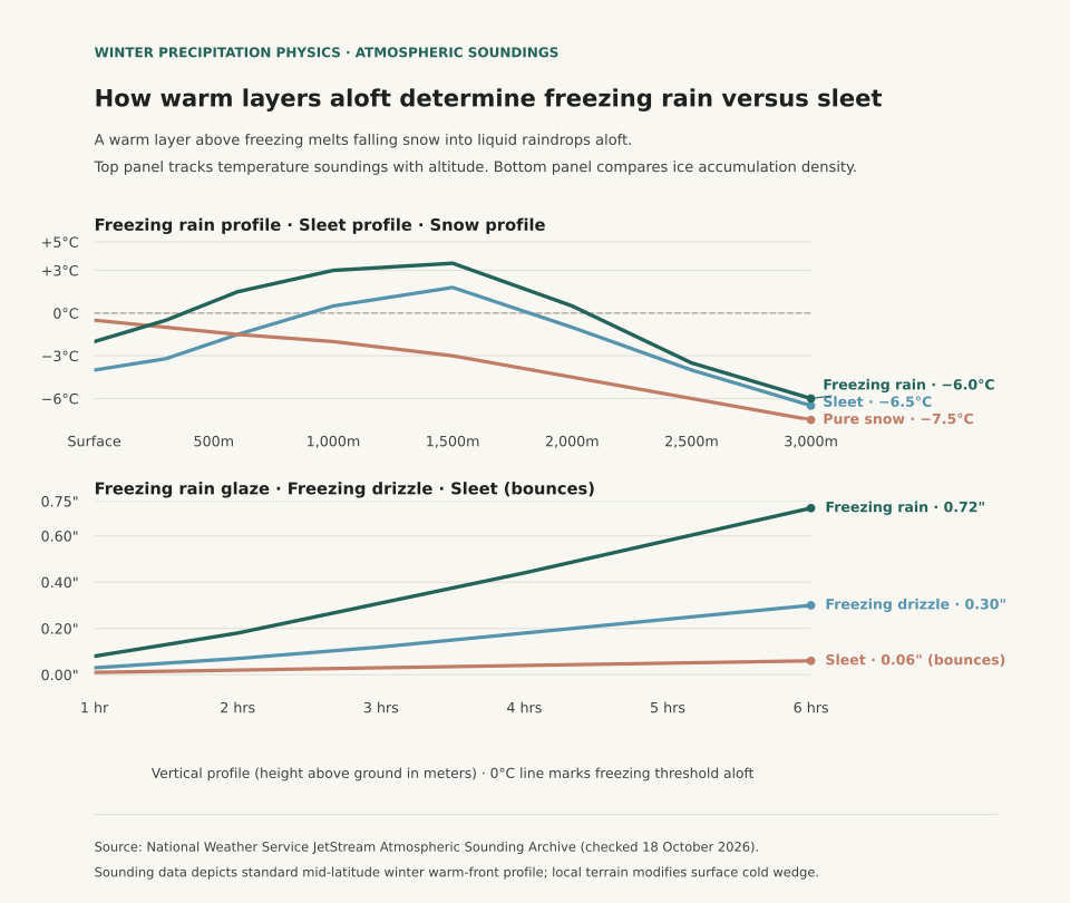
Atmospheric Sounding Mechanics: The Critical Warm Nose
Meteorologists evaluate winter storm threats using radiosonde soundings launched twice daily at NWS stations. In a classical warm-frontal overrunning pattern, warmer moist air from the Gulf of Mexico rides over a dense dome of cold polar air trapped at the surface. The table below traces temperature records at standard flight altitudes across the sounding profile:
| Altitude (m AGL) | Approx. Pressure Level | Freezing Rain Sounding | Sleet Sounding | Pure Snow Sounding | Physical State of Water |
|---|---|---|---|---|---|
| 3,000 m | 700 hPa | −6.0°C | −6.5°C | −7.5°C | Ice crystals and dendritic snowflakes form |
| 2,000 m | 800 hPa | +0.5°C | −1.0°C | −4.5°C | Warm air overrunning boundary; melting initiates |
| 1,500 m | 850 hPa | +3.5°C | +1.8°C | −3.0°C | Peak warm nose; snowflakes fully liquefy into rain |
| 1,000 m | 900 hPa | +3.0°C | +0.5°C | −2.0°C | Transition zone; sleet profile crosses back below 0°C |
| 600 m | 940 hPa | +1.5°C | −1.5°C | −1.5°C | Sleet drops freeze into solid pellets; freezing rain remains warm |
| Surface (0 m) | 1013 hPa | −2.0°C | −4.0°C | −0.5°C | Freezing rain glazes on contact; sleet bounces on pavement |
Because pure water droplets require microscopic freezing nuclei or mechanical shock to crystallize, liquid drops falling through a cold layer below 0°C can supercool rather than freeze immediately. A raindrop falling at terminal velocity (approximately 6 to 9 meters per second) requires at least 45 to 60 seconds of exposure to subfreezing air to dissipate latent heat and solidify into ice. In a shallow surface inversion of 250 meters, the drop traverses the subfreezing wedge in under 35 seconds, so it strikes the surface in liquid form.
Why Freezing Rain Causes Catastrophic Infrastructure Damage
While sleet accumulates on roads as loose, gritty slush that can be plowed, freezing rain produces structural glaze with a high physical density of approximately 0.90 to 0.92 grams per cubic centimeter. Under standard ice storm warning criteria established by the NWS, a quarter-inch (0.25 in / 6.4 mm) of radial glaze accumulation adds roughly 500 pounds of weight to an average power line span, while a half-inch accumulation can increase the radial cross-section by ten times, creating immense wind drag that snaps utility poles and mature tree limbs.
To follow how regional station baselines differ across winter seasons, review El Niño Winter Temperature History and Dew Point vs. Relative Humidity for insights into moisture evaporation rates during cold snaps.
Eranorms displays historical temperature distributions, upper-air soundings, and daily station climate normals across first-order weather stations nationwide. Open Eranorms in your browser, Download Eranorms for iPhone, or Get Eranorms on Android.