
Katabatic Winds vs. Foehn and Chinook Warming: Gravity Drainage vs. Compressional Heating
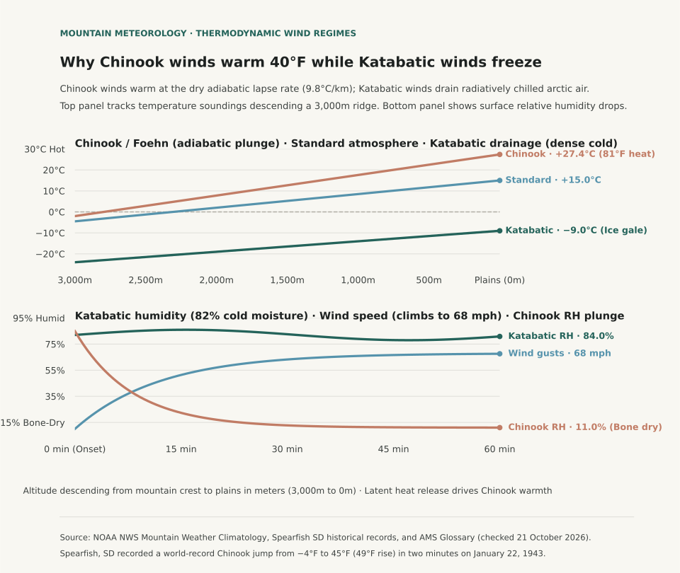
Downslope mountain winds produce opposite temperature extremes depending entirely on whether descending air is driven by radiatively chilled gravity drainage or forced adiabatic compressional heating. Under NOAA National Weather Service (NWS) Mountain Weather Climatology, katabatic winds (such as the Adriatic Bora, the French Mistral, and Antarctic plateau drainage) develop when nocturnal radiative cooling creates an exceptionally dense, subfreezing air mass atop an elevated plateau that cascades downward through mountain passes under the pull of gravity. While the descending air undergoes dry adiabatic compression (warming at approximately 9.8°C per kilometer, or 5.38°F per 1,000 feet), it begins from such an extreme deficit of cold that it arrives at low elevations significantly colder than the displaced valley air. In contrast, foehn and Chinook winds occur when strong synoptic pressure gradients force air across a mountain barrier: moisture condenses and precipitates on the windward slope at the moist adiabatic lapse rate (~5°C/km), releasing latent heat, before the parched air descends the leeward side at the rapid dry adiabatic rate, arriving at low elevations intensely hot, bone-dry, and gusty.
The contrast between these two thermodynamic pathways creates starkly different local environments. In the Black Hills of South Dakota, the historic Spearfish Chinook of 22 January 1943 remains the world's most dramatic temperature surge: a sudden downslope Chinook burst drove the surface temperature from −4°F (−20°C) at 7:30 AM to +45°F (+7.2°C) at 7:32 AM—a 49°F spike in exactly two minutes. Conversely, katabatic Bora winds along the Croatian coast routinely plunge coastal ports below freezing with 80+ mph gusts, despite descending from 3,000-foot coastal ridges.
Thermodynamics: Latent Heat Release vs. Radiative Chilling
The physical distinction between katabatic and foehn winds lies in the initial energy balance of the air parcel before descent begins. In a classic foehn or Chinook setup, moist air ascends a windward mountain barrier. As the parcel cools below its dewpoint, water vapor condenses into clouds and rain or snow. Condensation releases latent heat of vaporization (approximately 2.5 × 10⁶ joules per kilogram of water condensed), which slows the cooling rate to the moist adiabatic lapse rate (MALR, between 4°C and 6°C per kilometer). Because precipitation removes liquid water from the parcel, the air reaches the summit ridge stripped of its moisture. As it tumbles down the leeward slope, compression heats the dry air at the full dry adiabatic lapse rate (DALR, ~9.8°C per kilometer). Because the leeward warming rate significantly exceeds the windward cooling rate, the air arrives at the leeward base dramatically warmer and drier than at the equivalent windward altitude.
In a katabatic wind, no windward condensation or latent heat release takes place. Instead, prolonged terrestrial radiation during clear winter nights cools surface snow and air on an elevated plateau. Cold air is substantially denser than surrounding air (density ρ = P / (R * T)). As this cold, dense pool accumulates, gravity forces it to spill through saddles and canyons toward lower valleys. Although compressional heating warms the descending stream at the DALR, the descent distance is insufficient to overcome the severe initial temperature deficit. The katabatic jet hits the lowlands as an icy, turbulent gale.
| Downslope Wind Type | Primary Physical Driver | Ascent / Source Mechanism | Descent Lapse Rate | Valley Impact | Notable Geographic Examples |
|---|---|---|---|---|---|
| Katabatic Wind (Drainage / Fall Wind) | Negative buoyancy; gravity drainage of radiatively cooled dense air | Nocturnal radiation cooling over elevated snowpacks / plateaus | Dry adiabatic (9.8°C/km), but initial cold pool dominates | Sharp temperature drops, severe subfreezing wind chill, dense cold air pooling | Adriatic Bora, French Mistral, Antarctic plateau drainage, Santa Ana (cold-phase) |
| Foehn / Chinook (Compressional Warming) | Synoptic pressure gradient forcing air over mountain barrier | Moist adiabatic ascent with cloud condensation and precipitation fallout | Dry adiabatic (9.8°C/km) on leeward lee slopes | Violent temperature surges (+20°F to +50°F), rapid snow ablation, relative humidity crash (<15%) | Rocky Mountain Chinook, European Alpine Foehn, Canterbury Nor'wester, Santa Ana (warm-phase) |
Forecasting Downslope Hazards and Local Microclimates
Recognizing the difference between katabatic drainage and foehn warming is vital for aviation safety, wildland firefighting, and winter agriculture. Chinook winds cause explosive snow ablation (earning the historical nickname 'snow-eater') and drive relative humidity into single digits, priming mountain foothills for wildfire ignition. Katabatic gales, by contrast, create intense low-level mechanical turbulence without warning in coastal fjords and valleys, threatening shipping and aircraft approaches.
To explore how atmospheric lapse rates and boundary-layer dynamics govern regional microclimates, compare our detailed guides on Radiation Fog vs. Advection Fog Profiles and Freezing Rain vs. Sleet Sounding Profiles.
Eranorms models local elevation lapse rates, downslope wind trajectories, and historical sounding observations across meteorological stations worldwide. Open Eranorms in your browser, Download Eranorms for iPhone, or Get Eranorms on Android.