
Polar Vortex vs. Arctic Blast: Jet Stream Waviness, Rossby Waves, and Stratospheric Warming
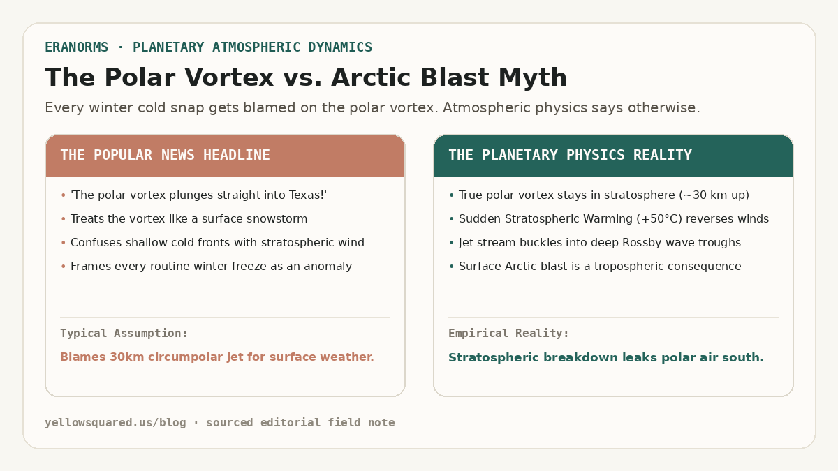
Whenever a winter cold front drops temperatures below freezing across Texas or the Ohio Valley, news broadcasters inevitably proclaim that 'the polar vortex has descended.' In reality, the meteorological feature known to atmospheric scientists as the stratospheric polar vortex never touches the ground. According to atmospheric dynamics research published by the NOAA Climate Prediction Center and convective sounding climatologies from NOAA NWS JetStream, the polar vortex is a massive, high-altitude cyclonic circulation that spins in the middle and upper stratosphere between 15 and 35 kilometers above Earth's surface (approximately 10 to 70 hPa). During an average polar winter, subfreezing temperatures over the Arctic ice sheet establish a steep latitudinal temperature gradient against the sunlit mid-latitudes. This thermal gradient powers roaring circumpolar westerly winds exceeding 100 miles per hour, acting as a tight atmospheric containment fence that bottles up bone-chilling air around the geographic North Pole.
What citizens experience at the surface as an 'Arctic blast' is entirely confined to the troposphere—the lowest 10 kilometers of the atmosphere where human weather lives. An Arctic blast is simply a dense, shallow wedge of continental polar (cP) or continental Arctic (cA) air moving southward behind a cold front. While the polar vortex can remain exceptionally strong and symmetrical aloft while an Arctic outbreak sweeps the Plains, the most severe continental freezes occur when a planetary disturbance shatters the vortex itself.
The polar vortex never descends to the ground; rather, its stratospheric disruption buckles the tropospheric jet stream into deep Rossby wave troughs that transport surface Arctic air south.
Sudden Stratospheric Warming and the Zonal Wind Reversal
The physical coupling between the high stratosphere and ground-level winter storms is mediated by planetary-scale atmospheric waves known as Rossby waves. Large mountain ranges (such as the Himalayas and the Rocky Mountains) and land-sea thermal contrasts force upward-propagating kinetic energy from the troposphere into the stratosphere. When these planetary waves break in the middle atmosphere, they deposit easterly momentum against the prevailing westerly jet.
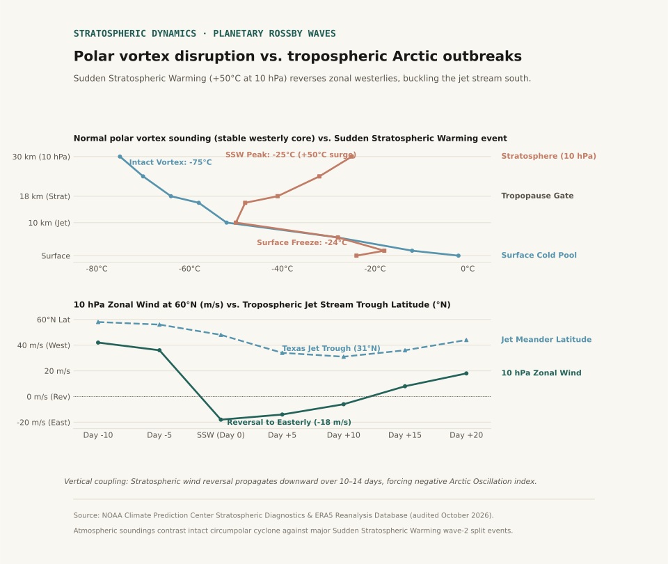
Under intense wave driving, the circumpolar vortex undergoes a dramatic phenomenon known as Sudden Stratospheric Warming (SSW). Within forty-eight to seventy-two hours, temperatures at the 10 hPa pressure level (approximately 30 km aloft) surge by 30°C to 50°C—warming from −75°C to −25°C. This immense thermal surge destroys the pole-to-equator pressure gradient, decelerating the 60°N zonal winds from 42 meters per second until they reverse direction, turning easterly (−12 to −18 m/s). This wind reversal formally defines a major SSW event.
Downward Propagation: How Stratospheric Buckling Reaches the Ground
A stratospheric warming event does not instantly trigger a ground-level blizzard. Instead, the dynamical anomaly slowly descends through the atmosphere over a period of seven to fourteen days via downward wave-mean flow interaction. As the easterly wind anomaly penetrates into the lower stratosphere (100 hPa) and upper troposphere (250 hPa), it weakens the polar jet stream.
A fast, zonal jet stream flows in a relatively straight west-to-east band along 55°N to 60°N, confining cold polar air to northern Canada. When the jet weakens, it loses its latitudinal stiffness and begins to meander, developing high-amplitude Rossby wave ripples. A blocking ridge of high pressure builds over Alaska and the eastern Pacific, forcing downstream troughs to plunge southward into the central United States, often reaching 31°N to 32°N across Texas and the Gulf Coast.
When the polar jet stream loses its zonal velocity, it behaves like an uncoiling spring, carving out low-pressure canyons that siphon subzero air directly into the subtropics.
| Meteorological Parameter | Stratospheric Polar Vortex | Tropospheric Arctic Outbreak | Coupling & Public Impact |
|---|---|---|---|
| Atmospheric Layer | Middle & Upper Stratosphere (10–70 hPa / 16–35 km) | Boundary Layer & Low Troposphere (Surface–850 hPa / 0–2 km) | Stratospheric disruption forces tropospheric jet meanders |
| Primary Circulation | Circumpolar westerly vortex around North Pole | Migratory high-pressure cold anticyclone (cP/cA air mass) | Surface high pressure pool reaches 1045+ hPa |
| Thermal Profile | Normally −70°C to −80°C; surges to −25°C in SSW | Surface chill drops 20°F to 40°F below seasonal baseline | Inversion lid decouples valley air from free flow |
| Event Timescale | Develops in autumn, persists through spring (months) | Passes across a region in 3 to 7 days | SSW effects influence surface weather for 30–60 days |
| Trigger Mechanism | Radiational cooling during polar night; Rossby wave absorption | Frontogenesis, cold advection, and meridional jet troughing | Negative Arctic Oscillation (AO) index phase |
Observational Limits and Climatological Context
Not every winter freeze is caused by a polar vortex disruption. Independent tropospheric dynamics—such as atmospheric blocking patterns over Greenland (the negative phase of the North Atlantic Oscillation) or tropical convective Madden-Julian Oscillation (MJO) pulses—routinely carve out deep cold-air troughs without any preceding stratospheric warming. Atmospheric reanalysis datasets from ECMWF ERA5 confirm that major SSW events occur only roughly once every two years in the Northern Hemisphere.
When evaluating seasonal forecasts, meteorologists monitor the 10 hPa zonal wind speed at 60°N and the Arctic Oscillation index, alongside local boundary-layer profiles covered in our guides on Temperature Inversions vs. Normal Lapse Rates and Wind Chill vs. Actual Air Temperature.
Eranorms lets you compare multi-decade daily temperature distributions, percentile bands, and historical extreme cold anomalies across global stations. Open Eranorms in your browser.