
Wind Chill vs. Actual Temperature: Why 20°F in Wind Cools Faster Than 0°F Calm
A 20°F winter day with a 30 mph wind cools exposed facial skin faster than calm 0°F air because moving air strips away the microscopic boundary layer of warmed, stagnant air that naturally clings to human skin. Under the National Weather Service (NWS) Wind Chill Temperature Index, 20°F air combined with a 30 mph wind generates an effective wind chill of 4.3°F and a convective heat flux exceeding 1,050 watts per square meter. In completely calm 0°F air, by contrast, the body's natural thermal boundary layer remains largely intact, cutting convective heat loss by over 45% and allowing skin surface temperatures to stabilize longer before freezing begins.
Winter sports enthusiasts and commuters often assume that the lowest reading on a mercury thermometer represents the greatest frostbite hazard. In 2001, the Office of the Federal Coordinator for Meteorology replaced the historical 1945 Siple-Passel Antarctic water-cylinder model with the Joint Action Group for Temperature Indices (JAG/TI) human tissue formula. Rather than measuring how fast water freezes inside an uninsulated plastic cylinder, the modern wind chill index calculates heat transfer from a human face walking at 3 mph into the wind at night. That model accounts for skin tissue resistance, facial blood flow, and wind velocity measured at a standard ten-meter anemometer height.
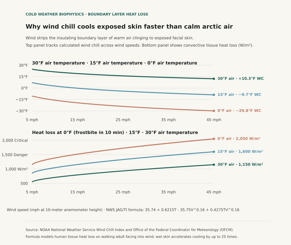
The Physics of the Thermal Boundary Layer
Still air is an outstanding thermal insulator with a thermal conductivity of approximately 0.024 watts per meter-kelvin. In calm conditions, metabolic heat escaping the skin warms a layer of air between one and three millimeters thick directly against the epidermis. This microclimatic cushion buffers the body against subfreezing surroundings. Wind disrupts this cushion through forced convection: moving air currents shear off the warm boundary layer and replace it continuously with cold ambient air, maximizing the temperature gradient across the skin barrier.
The modern NWS formula incorporates wind speed raised to the 0.16 power: Wind Chill = 35.74 + 0.6215*T − 35.75*(V^0.16) + 0.4275*T*(V^0.16), where T is air temperature in °F and V is wind speed in mph. Because the exponent is 0.16, the initial increase from calm to 15 mph causes the steepest drop in felt temperature; once wind speeds exceed 35 to 40 mph, additional velocity produces diminishing additional cooling because the boundary layer has already been stripped down to its aerodynamic limit.
| Air Temperature (°F) | Wind Speed (mph) | Calculated Wind Chill (°F) | Facial Heat Loss (W/m²) | Estimated Frostbite Onset Time |
|---|---|---|---|---|
| 30°F | 10 mph | 21.2°F | 720 W/m² | Frostbite unlikely (>60 minutes) |
| 30°F | 30 mph | 15.3°F | 1,050 W/m² | Frostbite unlikely (>60 minutes) |
| 15°F | 15 mph | 0.1°F | 1,180 W/m² | Low hazard (>30 minutes) |
| 15°F | 35 mph | −7.3°F | 1,480 W/m² | Increased hazard (30 minutes on exposed skin) |
| 0°F | 10 mph | −15.9°F | 1,510 W/m² | Increased hazard (30 minutes on exposed skin) |
| 0°F | 30 mph | −25.9°F | 1,890 W/m² | High danger: frostbite possible in 10 to 15 minutes |
| −15°F | 20 mph | −42.2°F | 2,250 W/m² | Critical danger: frostbite occurs in under 5 minutes |
Dressing for Boundary Layer Preservation
Understanding boundary layer physics clarifies why loose, wind-permeable knit scarves or open wool beanies perform poorly in blizzards. In high winds, air penetrates open-weave fabrics, destroying the warm air pockets trapped in the yarn. Effective winter protection requires an external, tightly woven, windproof shell (such as nylon or Gore-Tex) to stop convective shearing, paired with an inner loft layer (such as fleece or down) to trap non-circulating air against the body.
In addition, moisture accelerates heat loss dramatically: liquid water conducts heat roughly 25 times faster than still air. If perspiration dampens an inner cotton layer during outdoor exertion, the combination of wet skin and wind chill can induce hypothermia even when ambient temperatures sit above freezing. To evaluate broader winter storm patterns across northern stations, see Freezing Rain vs. Sleet: How Warm Layers Aloft Dictate Surface Icing and check El Niño Winter Temperature History.
Eranorms displays historical weather observations, wind velocity archives, and seasonal climate normal comparisons across first-order reporting stations nationwide. Open Eranorms in your browser, Download Eranorms for iPhone, or Get Eranorms on Android.