
Temperature Inversions vs. Normal Lapse Rates: How Boundary Layer Trapping Stagnates Winter Air
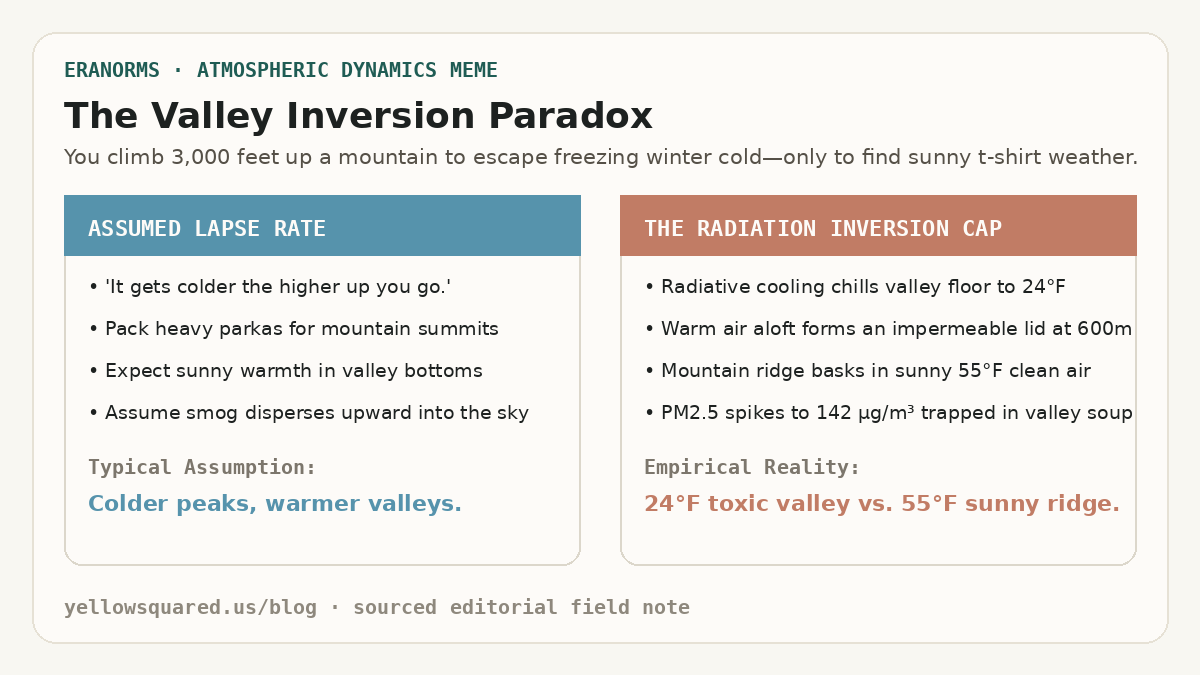
Winter hikers in mountainous valleys frequently experience a disorienting meteorological inversion: departing a freezing, smog-choked valley floor at 24°F (−4°C) under yellow-gray murk, only to ascend three thousand feet into brilliant sunshine and balmy 55°F (13°C) air. According to thermodynamic sounding climatologies maintained by the NOAA National Weather Service (NWS) and air monitoring records from the U.S. Environmental Protection Agency (EPA), this phenomenon occurs when radiational cooling and synoptic subsidence establish a persistent temperature inversion. Instead of the standard tropospheric environmental lapse rate—where temperatures drop approximately 6.5°C per kilometer (3.5°F per 1,000 feet) of altitude—temperature increases sharply with height across a shallow boundary layer, trapping particulate matter and vehicle emissions in a stagnant, unventilated cold pool.
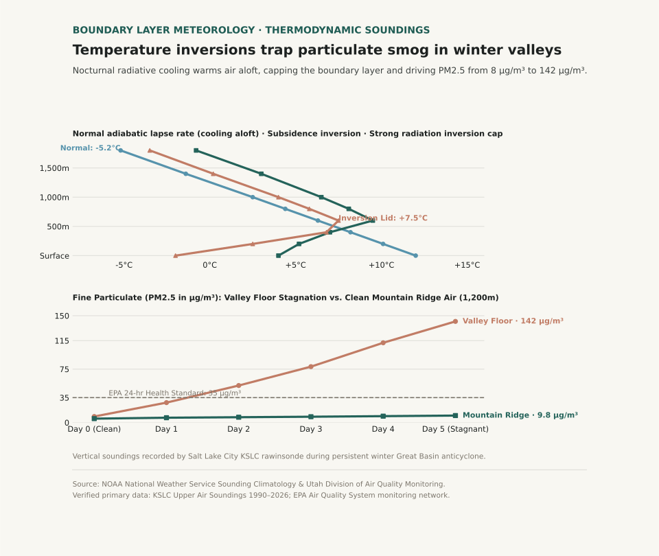
In topographically enclosed basins such as Utah's Salt Lake Valley, California's Central Valley, and Europe's Po Valley, winter inversions can persist uninterrupted for ten to fourteen days under stable anticyclones. Dense, radiatively chilled air drains into valley bottoms at night, creating a negative buoyancy barrier that prevents vertical convection. Meanwhile, descending air within the high-pressure ridge warms adiabatically, creating a warm 'lid' between 400 and 800 meters above ground level. Because the cap completely eliminates vertical atmospheric mixing, fine particulate matter (PM2.5) accumulates exponentially day after day.
An inversion lid does not merely slow down air circulation; it forms an impermeable thermal boundary that traps entire urban emission inventories inside a four-hundred-meter ceiling.
Thermodynamics: Negative Buoyancy and Boundary Layer Trapping
The stability of a boundary layer is governed by the vertical gradient of potential temperature (θ). Under normal afternoon conditions with solar insolation, the surface heats rapidly, establishing a dry-adiabatic lapse rate where air parcels displaced upward remain warmer than surrounding air, accelerating turbulent convective eddies that dilute ground-level pollutants through a mixing layer two kilometers deep. During winter inversions, snow-covered valley floors emit longwave infrared radiation directly to space under clear nighttime skies, plunging surface air temperatures far below the air aloft.
Because cold air is denser than warm air (ρ = P / (R * T)), this chilled surface pool possesses strong static stability: any parcel displaced upward becomes immediately colder and denser than its surroundings, generating a restoring buoyant force that snuffs out vertical turbulence. Smoke stacks, tailpipes, and home heating appliances discharge pollutants into a stagnant volume of air whose effective mixing height is compressed by over 80%. When a Pacific cold front finally approaches, the leading edge of strong gradient winds and cloud-induced thermal erosion breaks the inversion cap, scouring out the basin within hours.
During prolonged Great Basin inversions, surface air quality deteriorates from clean baseline levels to hazardous alert thresholds in less than seventy-two hours.
| Atmospheric Layer | Altitude AGL (m) | Normal Daytime Temp (°C) | Inversion Sounding Temp (°C) | PM2.5 Stagnation (Day 5) | Health Significance |
|---|---|---|---|---|---|
| Valley Floor (Surface) | 0 m | +12.0°C (53.6°F) | −2.0°C (28.4°F) | 142.0 µg/m³ | Very Unhealthy (AQI > 195); respiratory hazard |
| Lower Boundary Layer | 200 m | +10.1°C (50.2°F) | +2.5°C (36.5°F) | 138.0 µg/m³ | Extreme particulate trapping; zero vertical shear |
| Inversion Cap Core | 600 m | +6.3°C (43.3°F) | +7.5°C (45.5°F) | 45.0 µg/m³ | Thermal lid boundary; sharp haze horizon |
| Free Troposphere (Mountain) | 1,000 m | +2.5°C (36.5°F) | +4.0°C (39.2°F) | 8.0 µg/m³ | Good / Clean baseline; uncoupled air mass |
| High Ridge Crest | 1,800 m | −5.2°C (22.6°F) | −3.5°C (25.7°F) | 3.5 µg/m³ | Pristine regional air; full solar UV penetration |
Operational Mitigation and Activity Planning
For residents in intermountain valleys, recognizing the thermodynamic lifecycle of inversions allows proactive health management. During active inversion advisories, outdoor aerobic exercise should be shifted to mountain trailheads above the haze ceiling (typically above 4,500–5,000 feet in the Mountain West), where air quality remains pristine. At valley level, high-efficiency particulate air (HEPA) filtration running continuously indoors maintains indoor PM2.5 below 5 µg/m³ regardless of external stagnation.
To examine related atmospheric boundary layer dynamics, explore our guides on Radiation Fog vs. Advection Fog Sounding Profiles and Katabatic Drainage vs. Foehn Warming.
Eranorms models upper-air rawinsonde soundings, boundary layer mixing depths, and local temperature anomaly curves for reporting stations worldwide. Open Eranorms in your browser, Download Eranorms for iPhone, or Get Eranorms on Android.