
Wet vs. Dry Microburst Soundings: Inverted-V Profiles and 70 mph Downbursts
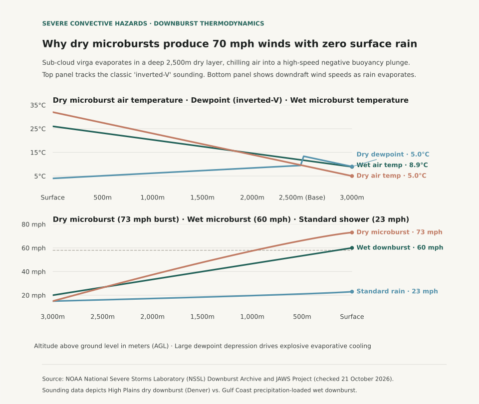
A dry microburst produces violent, life-threatening surface wind gusts exceeding seventy miles per hour with zero measurable rainfall at the ground because falling precipitation completely evaporates within a deep, two-thousand-meter sub-cloud layer of parched air. According to convective research documented by the NOAA National Severe Storms Laboratory (NSSL) and landmark wind shear investigations from the JAWS (Joint Airport Weather Studies) Project, dry microbursts develop beneath high-based convective clouds in semi-arid environments like the American High Plains and Intermountain West. When precipitation descends from cloud bases at 2,500 to 3,000 meters above ground level into an exceptionally dry sub-cloud boundary layer (evident as an 'inverted-V' signature on atmospheric soundings), intense evaporative cooling chills the descending air column far below environmental temperatures, triggering rapid negative buoyancy acceleration that slams into the surface as an explosive radial wind burst.
Pilots, boaters, and outdoor enthusiasts often associate severe wind shear exclusively with dark, torrential storm clouds. In a wet microburst—typical of the humid Gulf Coast and Midwest—the downburst is driven primarily by heavy precipitation drag and water loading alongside evaporative cooling, delivering blinding rain squalls with the gust front. In a dry microburst, radar displays only weak, benign reflectivity or faint virga aloft. By the time raindrops evaporate before touching the ground, the chilled air mass has accumulated immense kinetic momentum, producing sudden dust walls and 60 to 80 mph crosswinds beneath seemingly harmless overcast skies.
The Thermodynamics of the Inverted-V Sounding
Atmospheric soundings launched from High Plains stations (such as Denver, Salt Lake City, or Rapid City) in midsummer frequently exhibit the inverted-V profile. Near the surface, solar heating pushes afternoon air temperatures to 30°C–35°C (86°F–95°F) while dewpoints remain near 0°C–5°C (32°F–41°F), producing relative humidity under 15% and a deep dry-adiabatic lapse rate of nearly 9.8°C per kilometer.
When high-based altocumulus castellanus or weak thunderstorms develop aloft, raindrops entering the dry sub-cloud air vaporize rapidly. Evaporating water extracts 2.5 kilojoules of latent heat per gram from the surrounding air. The air parcel cools rapidly toward its wet-bulb temperature, becoming several degrees colder and significantly denser than the ambient environmental air at the same level. Gravity accelerates this cold, heavy air downward: negative buoyant acceleration is calculated as a = g * (T_env − T_parcel) / T_env. Over a 2,500-meter descent, this continuous cooling can accelerate a localized downdraft to vertical velocities of 40 to 60 feet per second, which deflect outward in all horizontal directions upon striking the ground.
| Microburst Parameter | Dry Microburst (High Plains / West) | Wet Microburst (Southeast / Midwest) | Hazard Significance |
|---|---|---|---|
| Convective Cloud Base | High (2,000 to 3,500 m AGL / 6,500–11,500 ft) | Low (800 to 1,500 m AGL / 2,500–5,000 ft) | Deep sub-cloud evaporation depth vs. shallow base |
| Surface Dewpoint Depression | Large (20°C to 30°C / 36°F to 54°F) | Small (2°C to 6°C / 4°F to 11°F) | Inverted-V sounding drives massive evaporative cooling |
| Primary Downdraft Driver | Evaporative cooling of virga (negative buoyancy) | Precipitation drag (water droplet loading) | Thermal chilling acceleration vs. physical mass drag |
| Surface Precipitation | None or trace sprinkles (Virga aloft) | Torrential downpour (2 to 4 inches / hour) | Zero visual rain warning vs. obvious rain shaft |
| Visual Warning Signs | Curving virga tendrils; blowing surface dust rings | Dark rain shaft; curling 'foot' on radar reflectivity | Sudden dust ring indicates ground-level impact |
| Peak Surface Wind Speeds | 60 to 80+ mph (Outflow diameter < 4 km) | 60 to 90+ mph (Accompanied by hail/lightning) | Violent low-level wind shear hazard to aviation |
Operational Safety: Recognizing the Warning Signs
Because dry microbursts lack obvious radar rain signatures, aviation meteorologists monitor Terminal Doppler Weather Radar (TDWR) and low-level wind shear alert systems (LLWAS) for divergent radial velocity signatures. For observers on the ground, the earliest visual sign of an impending dry microburst is virga—wispy streaks of precipitation trailing from high cloud bases that vanish before reaching the ground—followed seconds later by a sudden, circular roll of dust (a gust front) expanding outward across the terrain.
When high convective bases and large temperature-dewpoint depressions are present on morning soundings, treat even isolated virga showers as severe wind hazards. To examine how atmospheric temperature and dewpoint soundings govern winter storm hazards, explore Freezing Rain vs. Sleet Sounding Profiles, and read Wind Chill vs. Actual Temperature for boundary-layer heat transfer physics.
Eranorms displays historical sounding profiles, dewpoint depression timelines, and severe convective weather records across reporting stations nationwide. Open Eranorms in your browser, Download Eranorms for iPhone, or Get Eranorms on Android.