YellowSquared  /  Field notes

Notes from the workshop

56 posts, newest first. Choose an app to narrow the feed.

033 / 56

Why Is Buenos Aires Only 1 Hour Ahead of New York in Summer? How Argentina's Permanent UTC-3 Time Zone Works

Look at a globe and trace the 75°W meridian—the exact longitudinal center of North America’s Eastern Standard Time (UTC-05:00)—straight south from New York City (74.01°W) and Philadelphia: the line passes through Bogotá, Lima, and western South America, placing Santiago, Chile (70.67°W) and Mendoza, Argentina (68.84°W) only a few degrees to the east. Even Argentina’s Atlantic capital, Buenos Aires (58.38°W), sits firmly inside the natural 60°W (UTC-04:00) solar longitude band. Yet on the wall clock, all of Argentina observes Argentina Time (ART, permanent UTC-03:00) year-round—making Buenos Aires 1 hour ahead of New York in Northern Hemisphere summer and 2 hours ahead of New York in winter.

When you coordinate distributed engineering or finance teams across the Americas in Tempo, understanding why Argentina locked its clocks onto permanent Daylight Saving Time in 1969—and why western Argentine cities like Mendoza and Ushuaia experience solar noon after 1:30 PM—eliminates biannual scheduling surprises.

Why Argentina Sits in the UTC-4 and UTC-5 Solar Bands Yet Uses UTC-3

Because Earth rotates 15° every hour (4 minutes per degree of longitude), standard solar time zones are centered on multiples of 15° west of Greenwich (45°W = UTC-3, 60°W = UTC-4, 75°W = UTC-5). Comparing Argentina’s physical geography against its legal time history in Time in Argentina reveals a century-long drift eastward:

  • 1894–1920 (Córdoba Observatory Mean Time, UTC-04:16:48): Argentina’s first unified national railway time was anchored to the National Observatory in Córdoba (64°11'W), sitting 4 hours, 16 minutes, and 48 seconds behind Greenwich.
  • 1920–1969 (Standard UTC-04:00 With Summer UTC-03:00 DST): On May 1, 1920, Argentina joined the international meridian system at its natural 60°W zone (UTC-04:00), periodically advancing clocks to UTC-03:00 during summer for Daylight Saving Time.
  • 1969–Present (Permanent Daylight Saving Time on UTC-03:00): In the autumn of 1969, Argentina simply did not turn its clocks back from UTC-03:00 to UTC-04:00—converting former summer time into permanent standard time. Aside from brief crisis experiments with double-summer time (UTC-02:00 between 1974 and 2009, which western provinces fiercely resisted), Argentina has remained fixed at UTC-03:00 with zero DST transitions since March 2009.
Chart comparing civil clock lead ahead of local solar noon across Mendoza, Ushuaia, Cordoba, Buenos Aires, Santiago, New York, and Sao Paulo
Figure 1: Civil clock lead ahead of true astronomical solar noon (in minutes) across Argentine and Pan-American cities. Download the full coordinate and solar-noon dataset in south-america-argentina-utc-3-solar-noon-vs-new-york-table.csv.

Solar Noon & New York Offset Comparison Across the Americas

Because Argentina spans nearly 20 degrees of longitude from Bernardo de Irigoyen (53.6°W) in the northeast to Mount Fitz Roy (73.6°W) in Patagonia while sharing a single UTC-03:00 clock, the gap between wall-clock noon (12:00 PM) and true astronomical solar noon stretches past 95 minutes along the Andes:

City & Country IANA Time Zone Longitude Natural Solar Band Legal Civil Zone Clock Lead vs. Sun Mean Solar Noon
Mendoza, Argentina America/Argentina/Mendoza 68.84°W UTC-04:35 (UTC-5) ART (UTC-03:00) +95.4 min (+1h 35m) 13:35 (1:35 PM)
Ushuaia, Argentina America/Argentina/Ushuaia 68.30°W UTC-04:33 (UTC-5) ART (UTC-03:00) +93.2 min (+1h 33m) 13:33 (1:33 PM)
Córdoba, Argentina America/Argentina/Cordoba 64.18°W UTC-04:17 (UTC-4) ART (UTC-03:00) +76.7 min (+1h 17m) 13:17 (1:17 PM)
Buenos Aires, Argentina America/Argentina/Buenos_Aires 58.38°W UTC-03:54 (UTC-4) ART (UTC-03:00) +53.5 min (+0h 54m) 12:54 (12:54 PM)
New York, USA (Summer) America/New_York 74.01°W UTC-04:56 (UTC-5) EDT (UTC-04:00) +56.0 min (+0h 56m) 12:56 (12:56 PM)
Santiago, Chile (Winter) America/Santiago 70.67°W UTC-04:43 (UTC-5) CLT (UTC-04:00) +42.7 min (+0h 43m) 12:43 (12:43 PM)
São Paulo, Brazil America/Sao_Paulo 46.63°W UTC-03:07 (UTC-3) BRT (UTC-03:00) +6.5 min (+0h 07m) 12:07 (12:07 PM)

“When New York is on Daylight Saving Time (EDT, UTC-4) from March to November, its 56-minute solar clock skew almost exactly matches Buenos Aires’s permanent 54-minute solar skew on UTC-3—keeping the two cities just 60 minutes apart.”

Three Scheduling Rules for U.S., European, and Chilean Collaboration

  1. The Biannual U.S. Shift (+1 Hour Mar–Nov vs. +2 Hours Nov–Mar): Because Argentina does not observe Daylight Saving Time, every time difference change between Buenos Aires and North America is driven entirely by the U.S. clock. From the second Sunday in March to the first Sunday in November, 9:00 AM in New York (EDT) is 10:00 AM in Buenos Aires (+1 hr). From November to March, 9:00 AM in New York (EST) is 11:00 AM in Buenos Aires (+2 hrs).
  2. Crossing the Andes to Santiago (America/Santiago): Unlike Argentina, Chile still switches clocks twice a year between winter standard time (CLT, UTC-04:00, from April to September) and summer daylight time (CLST, UTC-03:00, from September to April). Thus driving or flying west from Mendoza to Santiago turns your watch back 1 hour in Southern Hemisphere winter, but requires zero clock change in Southern Hemisphere summer.
  3. Why Mendoza Has 9:00 AM Winter Sunrises and 10:00 PM Dinners: Just like Spain under Central European Time, western Argentina’s +95-minute permanent clock lead means midwinter sunrise in Mendoza does not occur until ~8:38 AM, while summer sunset occurs after 8:50 PM—explaining why Argentine restaurants rarely fill for dinner before 9:30 PM or 10:00 PM on the wall clock (8:00 PM–8:30 PM true solar time).

Scheduling recurring standups across New York, San Francisco, Buenos Aires, São Paulo, and London? Open Tempo in your browser to check live DST transitions and workday overlaps across all 12 Argentine IANA zones, or browse our global time-zone guides.

034 / 56

Why Are France and Spain 1 Hour Ahead of Solar Time? How Central European Time Places Madrid on Berlin's Clock

Look at a map of Europe and trace the Prime Meridian (0.00° longitude) straight south from London’s Royal Observatory in Greenwich: the line crosses western France near Bordeaux, slices through eastern Spain near Zaragoza and Castellón de la Plana, and leaves Madrid (3.70°W) and Vigo (8.72°W) well to the west of Britain. Geographically, all of mainland Spain and nearly all of France sit inside the natural Greenwich Mean Time (UTC+0) solar band. Yet on the wall clock, both France and Spain observe Central European Time (CET, UTC+1) in winter and Central European Summer Time (CEST, UTC+2) from late March to late October—putting Madrid on the exact same legal clock as Berlin (13.40°E), Warsaw (21.01°E), and Belgrade (20.46°E).

When you compare cross-border schedules in Tempo, that 1940 wartime clock shift creates two of Europe’s strangest time-zone jumps: flying west from Madrid to Lisbon (9.14°W) turns your watch back 1 hour, and flying north-northeast from Madrid to London (0.13°W) also turns your watch back 1 hour even though you traveled east toward the Prime Meridian.

The 15-Degree Solar Meridian Rule vs. Western Europe’s Legal Map

Because Earth rotates 360° every 24 hours, local solar time advances by exactly 15° of longitude per hour, or 4 minutes of solar time per degree of longitude:

  • Western European Time (WET, UTC+0): Centered on the Prime Meridian (0°), naturally spanning 7.5°W to 7.5°E. Under astronomical solar time, London (0.13°W), Paris (2.35°E), and Madrid (3.70°W) should all reach solar noon within 24 minutes of 12:00 UTC.
  • Central European Time (CET, UTC+1): Centered on the 15°E meridian (which passes through Görlitz on the German–Polish border, Prague, and Mount Etna in Sicily), naturally spanning 7.5°E to 22.5°E.
  • The 1940 Historical Divergence (Time in Spain): Spain adopted Greenwich Mean Time on January 1, 1901, and France adopted Paris-adjusted GMT in 1911. During World War II, however, General Francisco Franco’s government issued a ministerial order published in the Boletín Oficial del Estado on March 8, 1940: at 23:00 on March 16, 1940, Spanish clocks skipped forward 60 minutes to 00:00 (UTC+1) to align with Germany and occupied Europe. Occupied France shifted to Berlin time in June 1940 (with Vichy France following in early 1941). After 1945, neither country reversed the shift.
Chart comparing summer solar noon clock skew across Vigo, Madrid, Paris, Lisbon, Berlin, London, and Warsaw under Central European Summer Time
Figure 1: Total summer clock lead ahead of true astronomical solar noon (in minutes) across seven European cities. Download the underlying coordinate and solar-meridian table in cet-solar-noon-skew-spain-france-vs-longitude-table.csv.

Why Spain Eats Lunch at 2:00 PM and Dinner at 9:30 PM

Visitors to Madrid or Barcelona often assume that Spaniards eat lunch at 2:00 PM and dinner between 9:30 PM and 10:30 PM because of a uniquely nocturnal cultural preference. When you subtract the legal clock offset from local solar time, however, Spanish mealtimes occur at the exact same sun angle as the rest of Europe:

European City IANA Time Zone Longitude Solar Offset vs. 0° UTC Summer Legal Zone Summer Solar Noon (Wall Clock) Total Summer Skew
Vigo, Galicia (Spain) Europe/Madrid 8.72°W -34.9 min CEST (UTC+2) 14:35 (2:35 PM) +154.9 min (+2h 35m)
Madrid, Spain Europe/Madrid 3.70°W -14.8 min CEST (UTC+2) 14:15 (2:15 PM) +134.8 min (+2h 15m)
Paris, France Europe/Paris 2.35°E +9.4 min CEST (UTC+2) 13:51 (1:51 PM) +110.6 min (+1h 51m)
Lisbon, Portugal Europe/Lisbon 9.14°W -36.6 min WEST (UTC+1) 13:37 (1:37 PM) +96.6 min (+1h 37m)
Berlin, Germany Europe/Berlin 13.40°E +53.6 min CEST (UTC+2) 13:06 (1:06 PM) +66.4 min (+1h 06m)
London, United Kingdom Europe/London 0.13°W -0.5 min BST (UTC+1) 13:01 (1:01 PM) +60.5 min (+1h 01m)
Warsaw, Poland Europe/Warsaw 21.01°E +84.0 min CEST (UTC+2) 12:36 (12:36 PM) +36.0 min (+0h 36m)

“A Spaniard sitting down to lunch at 2:15 PM in Madrid during July is eating at exact astronomical solar noon (12:00 PM by the sun)—the exact same solar hour as a Berliner eating at 1:06 PM or a Londoner eating at 1:01 PM.”

Galicia vs. Portugal: The 2.5-Hour Double Daylight Saving Effect

The solar distortion reaches its extreme in northwestern Spain (Galicia), around Vigo (8.72°W), A Coruña (8.40°W), and Cape Touriñán (9.30°W). Because 8.72°W sits 23.72° west of the 15°E CET meridian, Vigo is already 95 minutes ahead of solar time in winter and 155 minutes (2 hours and 35 minutes) ahead of solar time in summer.

  1. Midwinter Sunrise After 9:00 AM: Around the December solstice, sunrise in Vigo and Santiago de Compostela does not occur until approximately 09:04 AM CET, meaning commuters and schoolchildren travel in pitch darkness for more than an hour after 8:00 AM.
  2. Midsummer Sunset After 10:15 PM: Around the June solstice, sunset in Galicia occurs at 22:17 (10:17 PM CEST), with civil twilight lasting past 22:55.
  3. Why Portugal Reverted to WET in 1996: Portugal experimented with switching from WET (UTC+0) to CET (UTC+1) between 1992 and 1996 to synchronize banking hours with Madrid and Brussels. After winter mornings remained dark until 9:00 AM in Lisbon (9.14°W) and summer evenings stayed bright past 10:00 PM, disturbing sleep cycles in schools, Portugal returned to Europe/Lisbon (UTC+0 winter / UTC+1 summer) in March 1996—while Spain’s Canary Islands (Atlantic/Canary) also remain 1 hour behind Madrid on UTC+0 / UTC+1.

Planning meetings across London, Lisbon, Madrid, Paris, and Berlin, or checking whether a Spanish regional office is on Peninsular time (Europe/Madrid) or Canary Islands time (Atlantic/Canary)? Open Tempo to compare live IANA offsets and solar daylight windows side by side, or browse our time-zone engineering guides.

035 / 56

Why Are Samoa and American Samoa 24 Hours Apart Despite Being 40 Miles Away? The 2011 International Date Line Jump

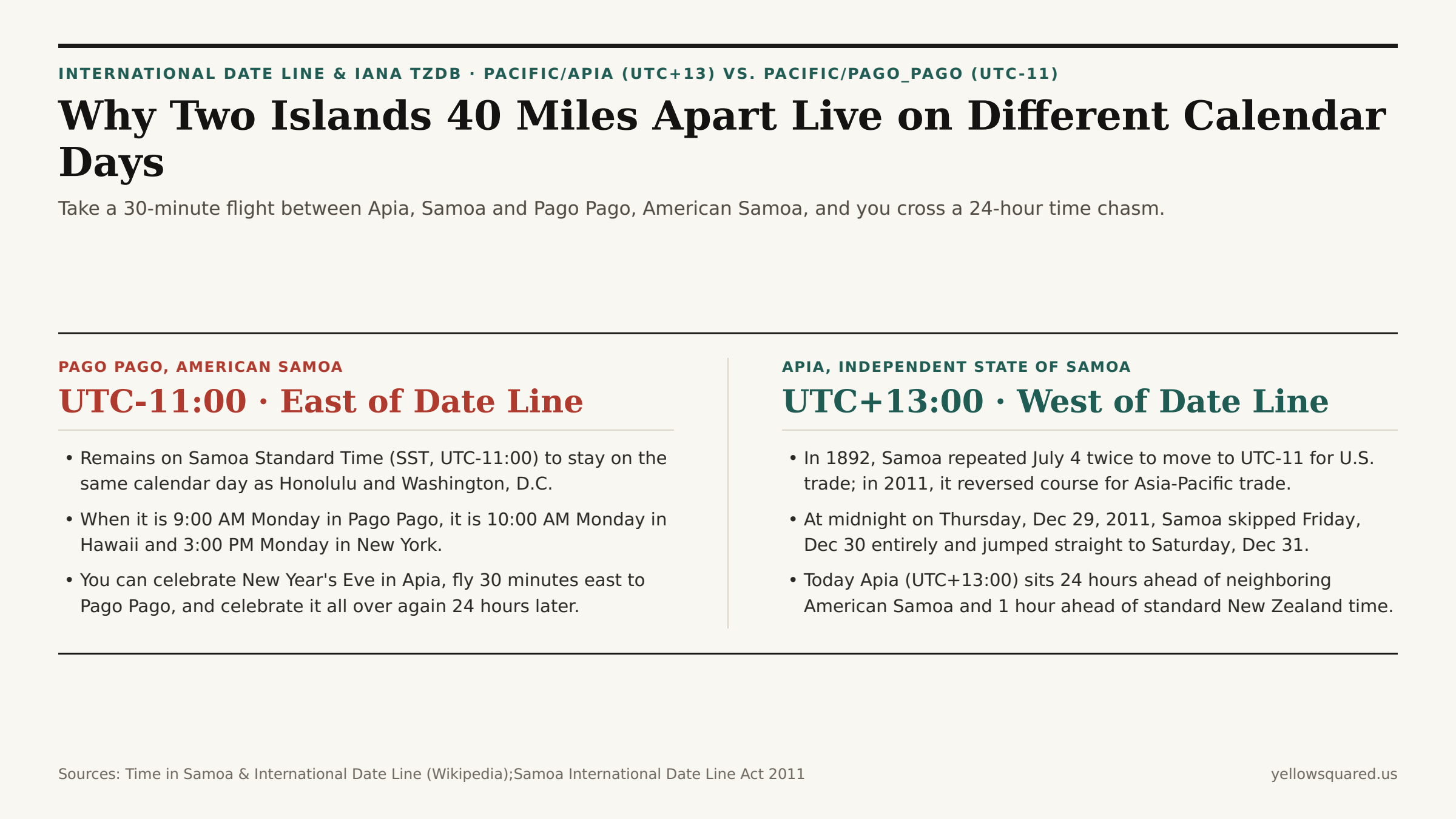
Board a twin-turboprop commuter plane at Faleolo International Airport in Apia, Samoa at 9:00 AM on Tuesday, fly just 40 miles (64 km) east across the ocean to Pago Pago International Airport in American Samoa, and check the clock on the terminal wall when you land 30 minutes later: it is 9:30 AM on Monday — 23 hours and 30 minutes before you took off.

As documented in Wikipedia's Time in Samoa Statutory History, the Samoa Time Zone (UTC-11:00) Reference, and the International Date Line Historical Record, the Independent State of Samoa (Pacific/Apia, UTC+13:00) and the U.S. territory of American Samoa (Pacific/Pago_Pago, UTC-11:00) sit on opposite sides of the International Date Line — creating a full 24-hour calendar gap between two islands in the same archipelago. To compare live dates and hours across Apia, Pago Pago, Auckland, and Honolulu right now, Open Tempo in your browser.

Comparison between Pago Pago, American Samoa on UTC-11 east of the International Date Line and Apia, Samoa on UTC+13 west of the International Date Line after the December 2011 calendar jump
Although Apia (171.8°W) sits slightly west of Pago Pago (170.7°W), Samoa's December 2011 jump across the International Date Line placed Apia 24 hours ahead of American Samoa.

1. Why Samoa Switched Sides of the Date Line Twice (1892 and 2011)

How did two neighboring Polynesian islands sharing a language, culture, and family ties end up a full calendar day apart? The story involves two historic economic pivots separated by 119 years (Time in Samoa):

  • The 1892 Pivot Toward California (Two Fourths of July): Prior to 1892, European missionaries and traders in Samoa kept Asian/Australian dates (4 hours ahead of Japan). In 1892, American traders persuaded King Malietoa Laupepa to shift Samoa east of the International Date Line (UTC-11:00) to match steamship schedules from San Francisco. Samoa accomplished that shift by celebrating Monday, July 4, 1892 twice in a row!
  • The 2011 Pivot Back Toward New Zealand & Australia (The Missing Friday): By the 21st century, Samoa's economic gravity had shifted overwhelmingly toward New Zealand (UTC+12:00 / +13:00), Australia (UTC+10:00 / +11:00), and East Asia. Sitting on UTC-11:00 meant Samoa was 23 hours behind Auckland: when it was Friday afternoon in Apia, banks in Auckland and Sydney were already closed for Saturday; when Auckland opened on Monday morning, Apia was still closed for Sunday — costing Samoan businesses two out of every five working days!
  • Skipping December 30, 2011: Under the International Date Line Act 2011, at midnight at the end of Thursday, December 29, 2011, the Independent State of Samoa (joined by the New Zealand territory of Tokelau) skipped Friday, December 30, 2011 completely and jumped 24 hours forward from UTC-11:00 to UTC+13:00 (Saturday, December 31, 2011). All employees scheduled to work on the vanished Friday were legally paid for the day, and hotel guests were explicitly exempted from paying for the nonexistent night. Meanwhile, American Samoa (a U.S. territory since 1900) stayed on UTC-11:00 to remain on the same calendar day as Washington, D.C. and Honolulu.
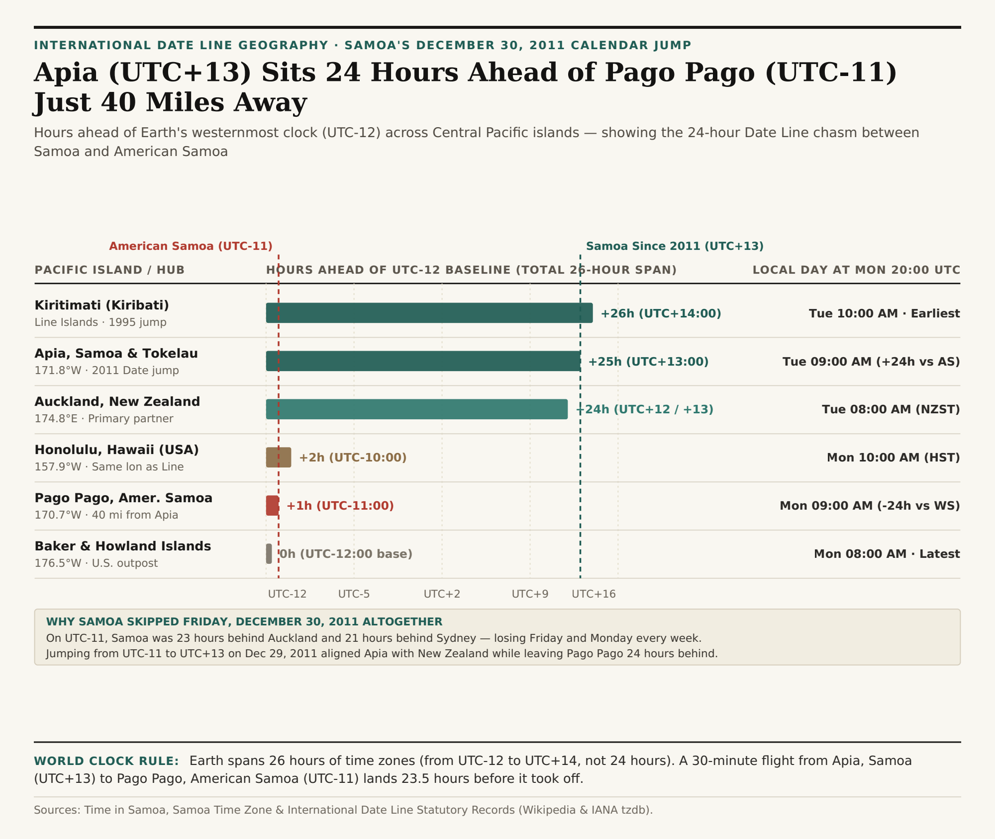
Horizontal bar chart comparing hours ahead of Earth's UTC-12 baseline across Kiritimati (+26h, UTC+14), Apia Samoa (+25h, UTC+13), Auckland (+24h, UTC+12), Honolulu (+2h, UTC-10), Pago Pago American Samoa (+1h, UTC-11), and Baker Island (0h, UTC-12)
Hours ahead of the UTC-12:00 baseline across Pacific jurisdictions — illustrating Earth's 26-hour total time-zone span. Download the Samoa & International Date Line dataset (CSV).

2. Why Earth Spans 26 Hours of Time Zones (UTC-12 to UTC+14), Not 24

As shown in International Date Line boundary records, Samoa's 2011 shift and Kiribati's earlier January 1, 1995 Date Line realignment (which moved the Line Islands — including Kiritimati / Christmas Island at 157.4°W — to UTC+14:00 so Kiribati wouldn't be split across two days) created a remarkable global quirk:

  1. Honolulu (157.9°W) and Kiritimati (157.4°W) Sit on the Exact Same Longitude: Kiritimati lies due south of Oahu along the ~157.5°W meridian. Therefore, both islands share the exact same clock minutes (10:00 AM vs. 10:00 AM) — yet Kiritimati (UTC+14:00) is a full 24 hours ahead of Honolulu (UTC-10:00)!
  2. 3 Hours per Day When Three Calendar Dates Coexist on Earth: Because the earliest time zone on Earth is UTC+14:00 (Line Islands) and the latest is UTC-12:00 (Baker and Howland Islands), the total span across Earth's time zones is 26 hours. Every day between 10:00 UTC and 11:59 UTC, three different calendar dates exist simultaneously on Earth (for example, late Monday on Baker Island at UTC-12, Tuesday across Europe/Americas/Asia, and early Wednesday morning in Kiritimati at UTC+14 and Apia at UTC+13)!

"Because Apia (UTC+13) and Pago Pago (UTC-11) sit just 40 miles apart on opposite sides of the International Date Line, you can ring in the New Year at midnight in Samoa, board a 30-minute flight to American Samoa, and celebrate New Year's Eve a second time 24 hours later."

Pacific Jurisdiction IANA Zone Longitude UTC Offset At Mon 20:00 UTC Date Line Side & History
Kiritimati (Line Islands, Kiribati) Pacific/Kiritimati 157.4°W UTC+14:00 Tue 10:00 AM West (Jumped Date Line in 1995)
Apia, Samoa & Tokelau Pacific/Apia 171.8°W UTC+13:00 Tue 09:00 AM West (Skipped Dec 30, 2011)
Auckland, New Zealand Pacific/Auckland 174.8°E UTC+12 / +13 Tue 08:00 AM West (Primary Polynesia trade hub)
Honolulu, Hawaii (USA) Pacific/Honolulu 157.9°W UTC-10:00 Mon 10:00 AM East (24h behind Kiritimati at same lon!)
Pago Pago, American Samoa Pacific/Pago_Pago 170.7°W UTC-11:00 Mon 09:00 AM East (24h behind Apia 40 miles away!)
Baker & Howland Islands (USA) Etc/GMT+12 176.5°W UTC-12:00 Mon 08:00 AM East (26h behind Kiritimati)

Checking Date-Line Crossings Before You Book

Kiritimati and Honolulu sit at similar longitudes but fall on opposite sides of the International Date Line, so their calendar dates can differ by a full day.

Whether you are coordinating South Pacific flights between Auckland (UTC+12/+13), Apia (UTC+13), Fiji (UTC+12), and Pago Pago (UTC-11), or verifying whether a remote teammate in Oceania is already on tomorrow's calendar date, Open Tempo in your browser to inspect live day-and-hour badges side by side, and download the Samoa & International Date Line CSV dataset.

036 / 56

Why Does Hawaii Never Change Clocks for Daylight Saving Time? How the 6-Hour Gap With New York Shifts to 5 Hours

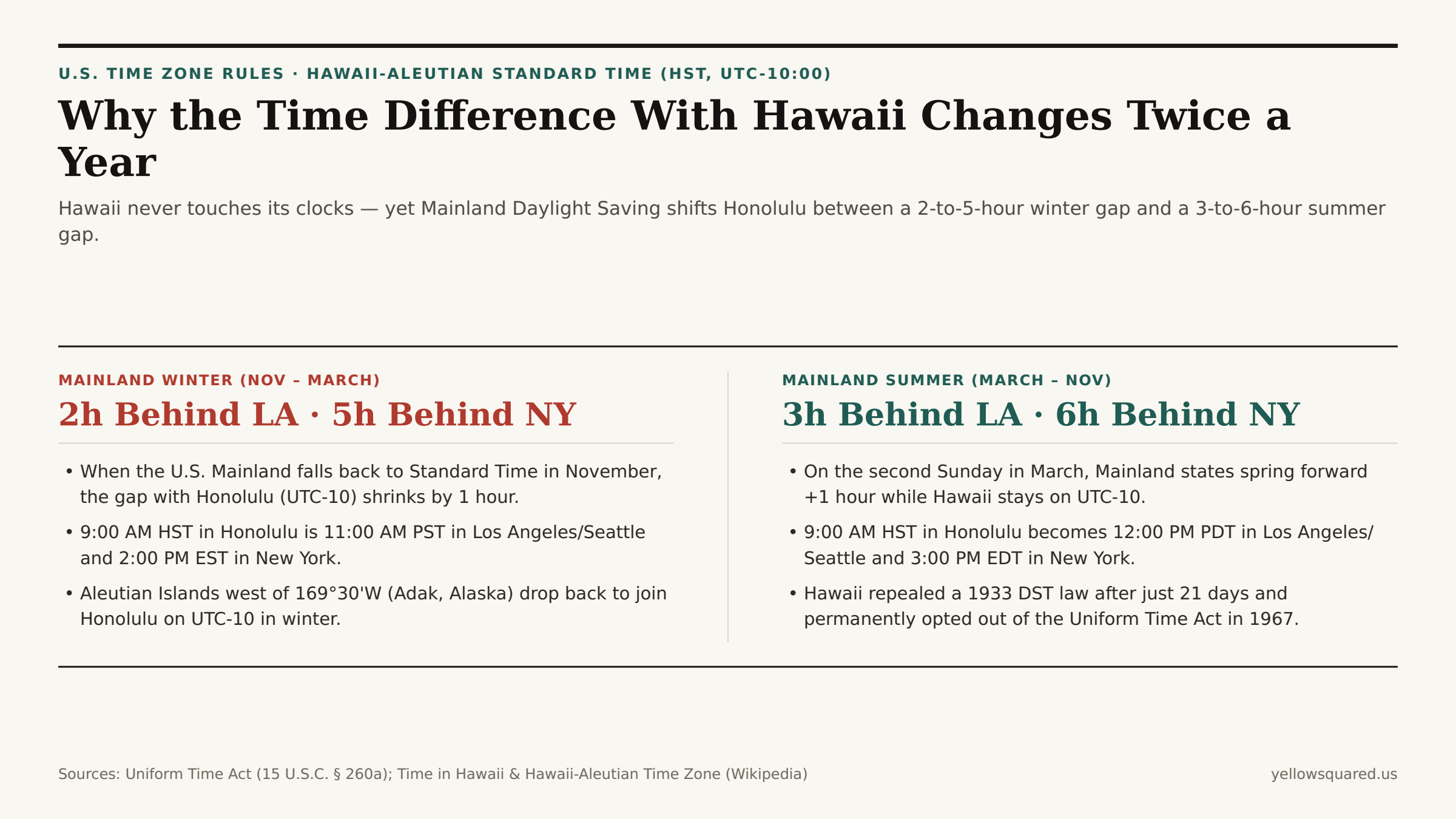
If you live on the U.S. Mainland and schedule a recurring weekly check-in with family, clients, or resort teams in Honolulu, you have probably been burned by a twice-a-year calendar shift: from November to March, Hawaii sits 2 hours behind Los Angeles and 5 hours behind New York; from March to November, Hawaii suddenly sits 3 hours behind Los Angeles and 6 hours behind New York. Yet no one in Honolulu ever touched a clock.

As documented in Wikipedia's Time in Hawaii Statutory & Historical Record, the Hawaii–Aleutian Time Zone Reference, and Daylight Saving Time in the United States, Hawaii (Pacific/Honolulu, HST, UTC-10:00) is one of only two U.S. states (alongside Arizona) that permanently opted out of Daylight Saving Time under the federal Uniform Time Act of 1966 (15 U.S.C. § 260a). To compare live clock overlaps between Honolulu and any Mainland or international city across winter and summer dates, Open Tempo in your browser.

Comparison between the Mainland Winter gap with Hawaii (2 hours behind LA, 5 hours behind NY) and the Mainland Summer gap with Hawaii (3 hours behind LA, 6 hours behind NY)
Because Hawaii remains on Hawaii Standard Time (UTC-10:00) all year while 48 Mainland states spring forward in March, Honolulu's time gap with the Mainland widens by a full hour every spring and shrinks every fall.

1. The Tropical Latitude Math: Why 21.3°N Has Almost No Extra Summer Daylight to "Save"

Why do high-latitude cities like Seattle (47.6°N), London (51.5°N), or Anchorage (61.2°N) care so much about shifting clocks in summer, whereas Hawaii rejected Daylight Saving Time unanimously in 1967? The answer is spherical astronomy and Earth's 23.44-degree axial tilt:

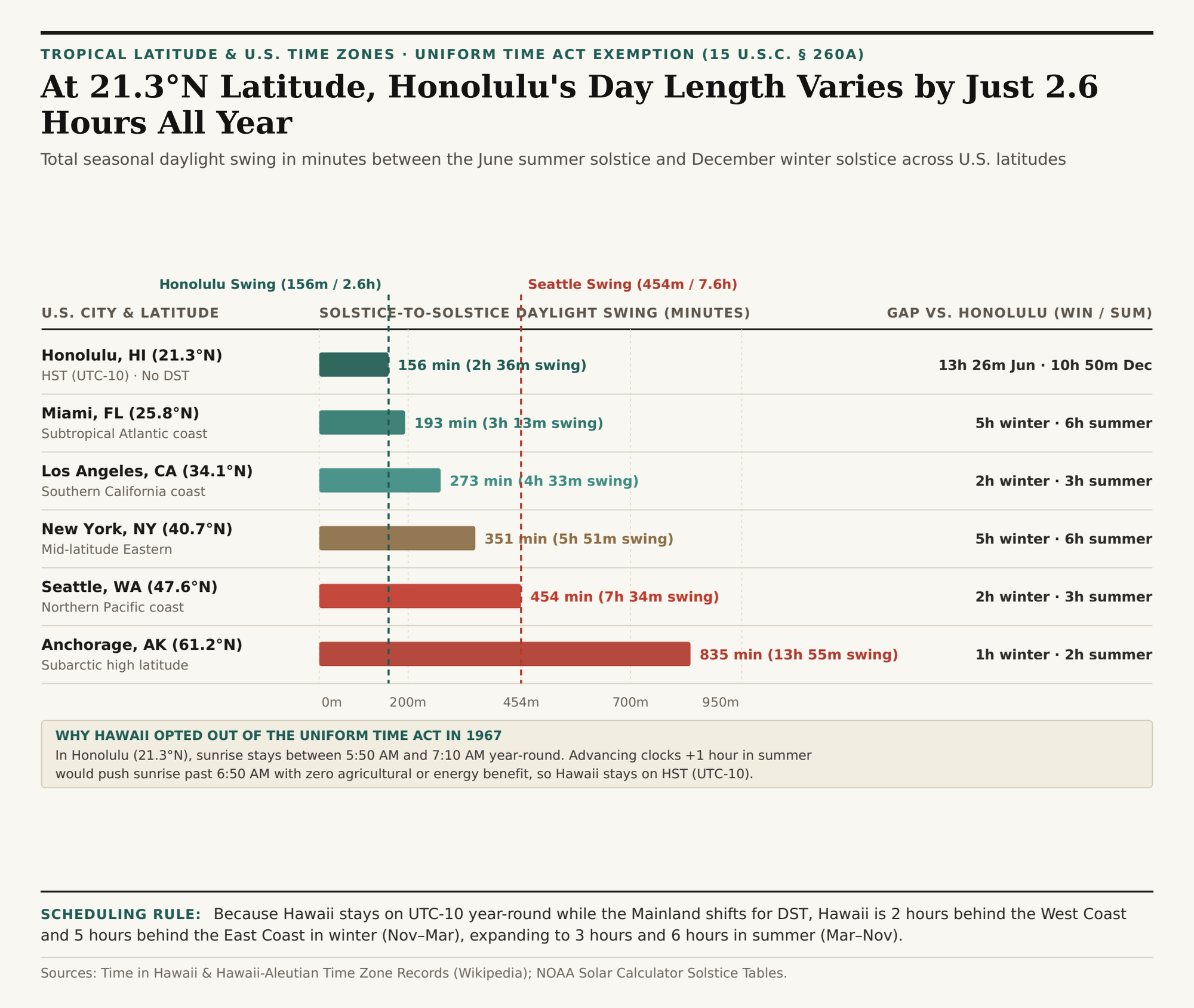
  • Minimal Seasonal Swing Near the Tropics (21.3°N): Honolulu sits at 21°18'N latitude — just two degrees south of the Tropic of Cancer (23.44°N). On the June summer solstice, Honolulu receives 13 hours and 26 minutes of daylight (sunrise ~5:50 AM, sunset ~7:16 PM). On the December winter solstice, Honolulu still receives 10 hours and 50 minutes of daylight (sunrise ~7:04 AM, sunset ~5:55 PM) — a total seasonal swing of just 156 minutes (2 hours and 36 minutes) across the entire year.
  • Compare That With Mid- and High-Latitude Mainland Cities: In New York (40.7°N), day length swings by 351 minutes (5 hours and 51 minutes, from 9h 15m in December to 15h 06m in June). In Seattle (47.6°N), day length swings by 454 minutes (7 hours and 34 minutes, from 8h 25m to 15h 59m). Without DST in June, sunrise in Seattle or Boston would occur near 4:10 AM while millions of people are asleep.
  • Why DST Would Backfire in Hawaii: Because Honolulu's summer sun already rises around 5:50 AM and sets past 7:15 PM, advancing clocks by an hour (UTC-9:00) would push late-summer and autumn sunrises toward 7:00 AM–7:30 AM — forcing morning commuters, schoolkids, and ocean paddlers into darkness with zero energy savings.
Horizontal bar chart comparing solstice-to-solstice daylight swing in minutes across Honolulu (156 min), Miami (193 min), Los Angeles (273 min), New York (351 min), Seattle (454 min), and Anchorage (835 min)
Solstice-to-solstice daylight swing (minutes between June 21 and December 21) across U.S. latitudes. Download the Hawaii vs. Mainland solstice daylight dataset (CSV).

2. Hawaii's 21-Day 1933 Experiment, WWII "Hawaii War Time" (UTC-9:30), and the Aleutian Split

While Hawaii never observes Daylight Saving Time today, historical territorial records reveal two fascinating chapters when Hawaiian clocks moved:

  1. The 21-Day Repeal of 1933: On April 30, 1933, the Territorial Legislature enacted Daylight Saving Time across Hawaii. Public backlash over dark mornings was so immediate and fierce that lawmakers repealed the statute just three weeks later, on May 21, 1933.
  2. Half-Hour Clocks Until 1947 (UTC-10:30 & UTC-9:30): From 1900 until 1947, Hawaii's standard time was actually a half-hour zone — GMT-10:30, anchored to the 157.5°W meridian passing directly between Oahu (157.86°W) and Maui (156.33°W). During World War II (between February 9, 1942 and September 30, 1945), the territory shifted one hour ahead to year-round Hawaii War Time (GMT-9:30). In June 1947, Hawaii permanently standardized on whole-hour GMT-10:00 (HST).
  3. Why the "Hawaii–Aleutian Time Zone" Splits Every Summer: Hawaii shares the UTC-10:00 zone with the westernmost Aleutian Islands of Alaska (west of 169°30'W, such as Adak at 51.88°N). Because Alaska does observe Daylight Saving Time, Adak (America/Adak) springs forward to Hawaii–Aleutian Daylight Time (HDT, UTC-9:00) from March to November, while Honolulu (Pacific/Honolulu) stays on HST (UTC-10:00)!

"In 1933, Hawaii tried Daylight Saving Time once — and repealed it after just 21 days. At 21°N latitude, nature already distributes sunlight evenly between 6:00 AM and 7:00 PM all year long."

City & State Latitude June Solstice Dec Solstice Annual Swing Gap vs. Honolulu (Win / Sum)
Honolulu, HI (Pacific/Honolulu) 21.31°N 13h 26m 10h 50m 156 min (2.6h) 0h year-round (UTC-10)
Miami, FL (America/New_York) 25.76°N 13h 45m 10h 32m 193 min (3.2h) 5h winter / 6h summer
Los Angeles, CA (America/Los_Angeles) 34.05°N 14h 26m 9h 53m 273 min (4.6h) 2h winter / 3h summer
New York, NY (America/New_York) 40.71°N 15h 06m 9h 15m 351 min (5.9h) 5h winter / 6h summer
Seattle, WA (America/Los_Angeles) 47.61°N 15h 59m 8h 25m 454 min (7.6h) 2h winter / 3h summer
Anchorage, AK (America/Anchorage) 61.22°N 19h 22m 5h 27m 835 min (13.9h) 1h winter / 2h summer

Checking Mainland-to-Hawaii Overlaps Before You Book

Because a 9:00 AM HST morning kickoff in Honolulu lands at 2:00 PM EST in New York during January but 3:00 PM EDT in July, anchoring recurring invites carefully prevents missed afternoon windows on the East Coast. Open Tempo in your browser to scrub across winter and summer Mainland-to-Hawaii offsets, and download the Hawaii solstice daylight & DST CSV table.

037 / 56

Why Does Australia Have 5 Time Zones in Summer? Half-Hour Clocks and Daylight Saving Explained

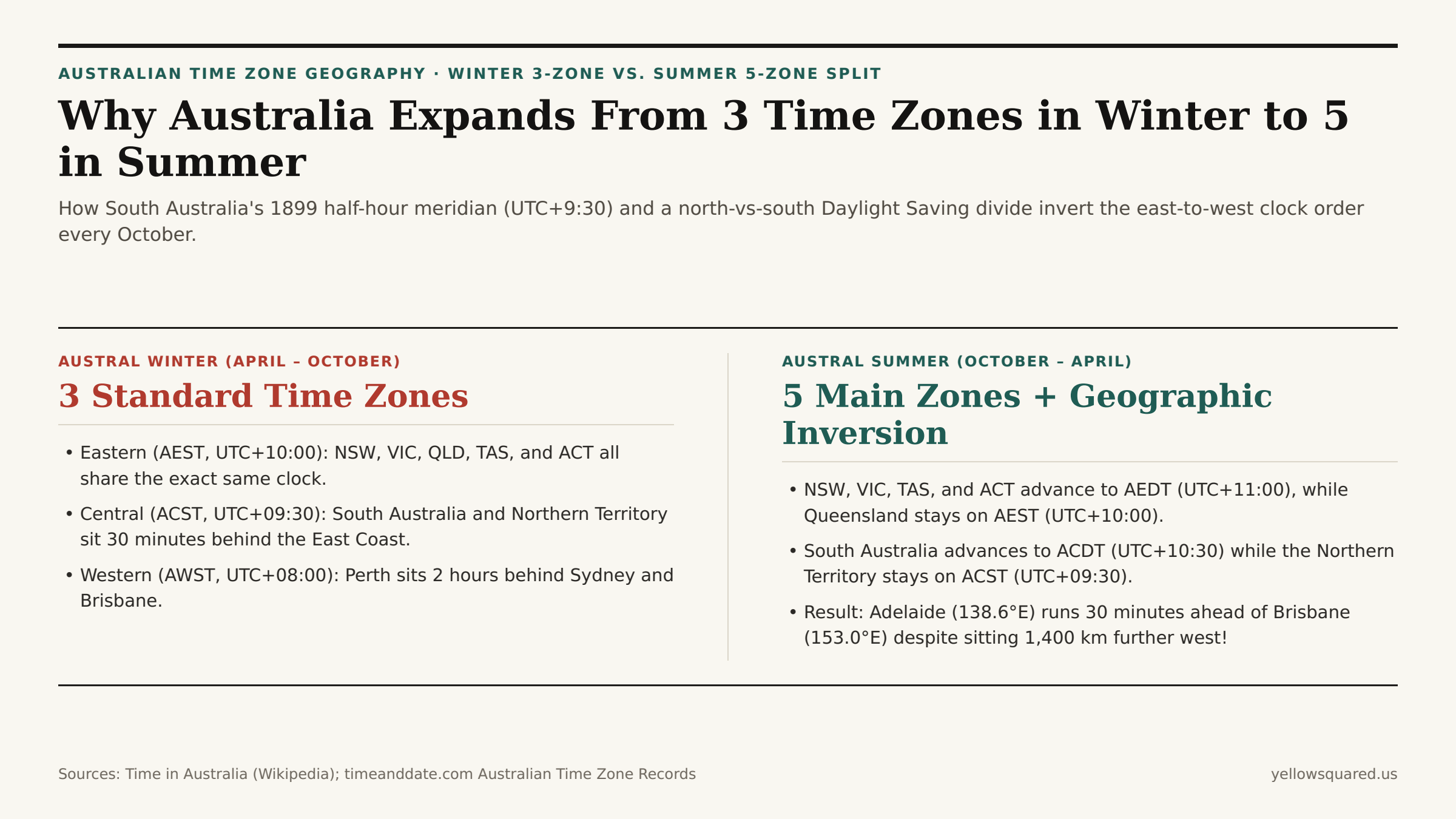
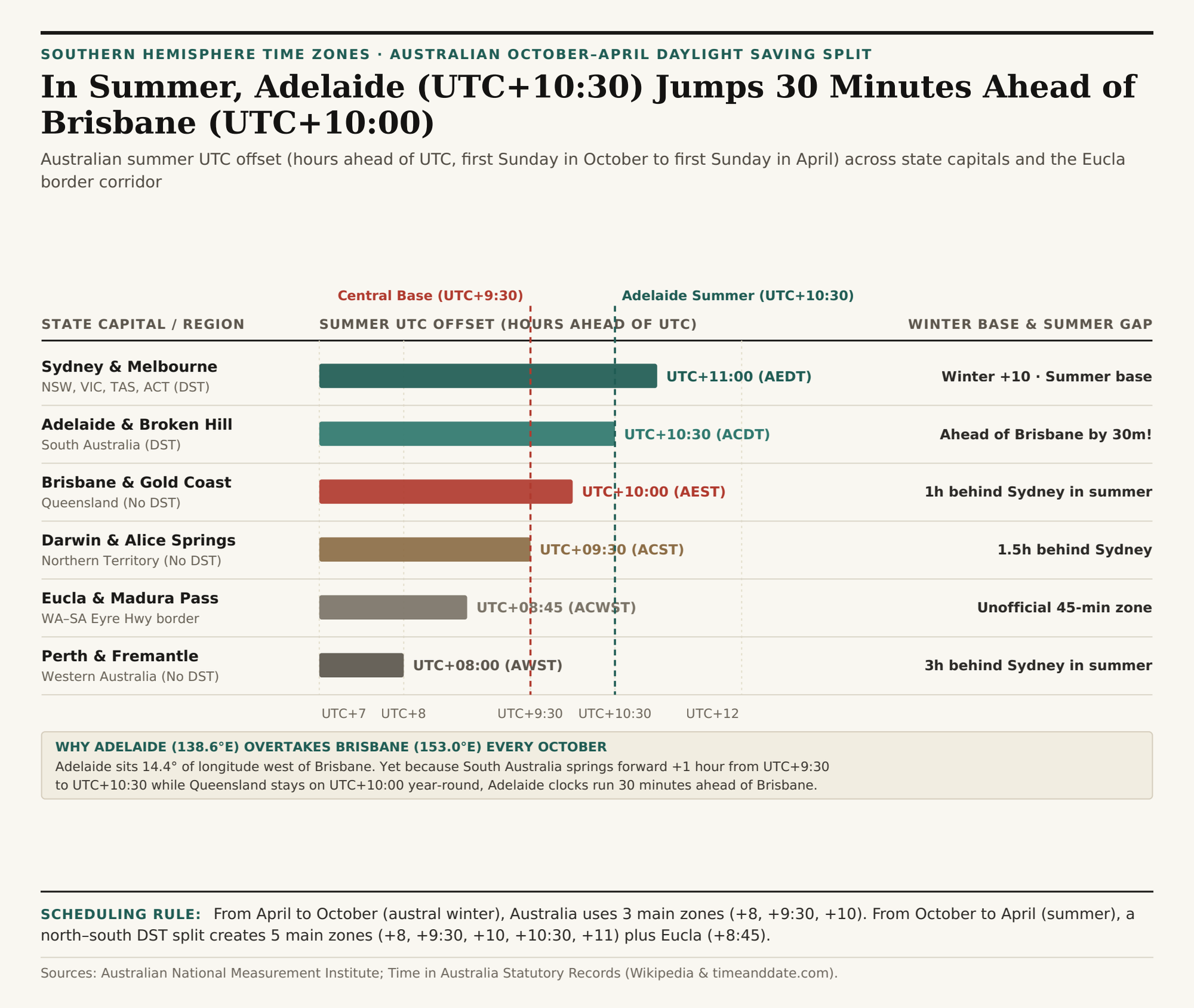
Schedule a nationwide conference call across Australia in July (austral winter), and the country divides neatly into three standard time zones: Western (AWST, UTC+8), Central (ACST, UTC+9:30), and Eastern (AEST, UTC+10). Schedule that exact same meeting between the first Sunday in October and the first Sunday in April (austral summer), and Australia splinters into five main time zones — with Adelaide (UTC+10:30) jumping 30 minutes ahead of Brisbane (UTC+10:00) even though Adelaide sits 1,400 kilometers further west.

As documented in Wikipedia's Time in Australia Statutory & Historical Record and Time and Date's Australian World Clock Directory, this seasonal checkerboard happens because Australia's southern states observe Daylight Saving Time while its northern and western states do not. To compare live offsets across Sydney, Brisbane, Adelaide, Darwin, and Perth without mental math, Open Tempo in your browser.

Comparison between Australia's 3 standard winter time zones (April to October) and its 5 summer time zones (October to April) showing how Adelaide overtakes Brisbane
From October to April, Australia's north-south Daylight Saving split expands 3 winter time zones into 5 summer zones and places South Australia (UTC+10:30) 30 minutes ahead of Queensland (UTC+10:00).

1. Why South Australia and the Northern Territory Use a Half-Hour Offset (UTC+9:30)

When the Australian colonies first standardized their clocks in February 1895, South Australia (which then administered the Northern Territory) initially adopted GMT+9:00 based on the 135°E meridian. However, Adelaide's business community and astronomical observatory (located at 138.60°E) protested that GMT+9:00 placed Adelaide a full hour behind Melbourne and Sydney while setting solar noon 14 minutes early, cutting into afternoon commercial and cricket hours.

Under the Standard Time Act of 1898 (taking effect in May 1899), South Australia split the difference by advancing its clocks 30 minutes to GMT+9:30 (anchored to the 142.5°E meridian). Even today, both South Australia and the Northern Territory keep Australian Central Standard Time (ACST, UTC+9:30) as their baseline winter clock — and the remote silver-mining town of Broken Hill, New South Wales (Australia/Broken_Hill), located near the South Australian border, also observes UTC+9:30 due to its historical rail and telegraph links to Adelaide.

Horizontal bar chart comparing summer UTC offsets across Sydney/Melbourne (UTC+11), Adelaide (UTC+10:30), Brisbane (UTC+10), Darwin (UTC+9:30), Eucla (UTC+8:45), and Perth (UTC+8)
Summer UTC offsets across Australian capitals and border zones from the first Sunday in October to the first Sunday in April. Download the Australian 5-zone summer split dataset (CSV).

2. How the October–April Daylight Saving Split Creates 5 Main Zones (Plus Eucla's UTC+8:45)

Because northern and tropical Australia (Queensland, the Northern Territory, and Western Australia) sit closer to the equator — where summer day length varies far less and residents prefer earlier sunset cooling — those three jurisdictions rejected Daylight Saving Time in state referendums. Meanwhile, the higher-latitude southern states (New South Wales, Victoria, Tasmania, South Australia, and the Australian Capital Territory) spring forward +1 hour on the first Sunday in October and fall back on the first Sunday in April:

  • UTC+11:00 — Australian Eastern Daylight Time (AEDT): Observed by Sydney (NSW), Melbourne (VIC), Hobart (TAS), and Canberra (ACT).
  • UTC+10:30 — Australian Central Daylight Time (ACDT): Observed by Adelaide (SA) and Broken Hill (NSW). Because Adelaide adds +1 hour to its UTC+9:30 base while Brisbane stays still on UTC+10:00, Adelaide runs 30 minutes ahead of Brisbane all summer long.
  • UTC+10:00 — Australian Eastern Standard Time (AEST): Observed year-round by Brisbane, the Gold Coast, and Cairns (QLD).
  • UTC+09:30 — Australian Central Standard Time (ACST): Observed year-round by Darwin and Alice Springs (NT).
  • UTC+08:00 — Australian Western Standard Time (AWST): Observed year-round by Perth (WA) — sitting 3 full hours behind Sydney in summer.

"Drive across the Nullarbor Plain on the Eyre Highway near the Western Australia–South Australia border, and roadhouses in Eucla, Madura, and Mundrabilla observe an unofficial sixth mainland zone: Australian Central Western Standard Time (UTC+8:45) — splitting the 90-minute gap between Perth and Adelaide into two 45-minute steps."

City / Region IANA Time Zone Longitude Winter (Apr–Oct) Summer (Oct–Apr) Summer Gap vs. Sydney
Sydney, Melbourne, Canberra & Hobart Australia/Sydney 151.21°E UTC+10:00 (AEST) UTC+11:00 (AEDT) 0 min (Baseline)
Adelaide (SA) & Broken Hill (NSW) Australia/Adelaide 138.60°E UTC+09:30 (ACST) UTC+10:30 (ACDT) -30 min (+30m ahead of QLD)
Brisbane & Gold Coast (QLD) Australia/Brisbane 153.03°E UTC+10:00 (AEST) UTC+10:00 (AEST) -60 min (No DST)
Darwin & Alice Springs (NT) Australia/Darwin 130.84°E UTC+09:30 (ACST) UTC+09:30 (ACST) -90 min (No DST)
Eucla & Border Village (Eyre Hwy) Australia/Eucla 128.88°E UTC+08:45 (ACWST) UTC+08:45 (ACWST) -135 min (45-min offset)
Perth & Fremantle (WA) Australia/Perth 115.86°E UTC+08:00 (AWST) UTC+08:00 (AWST) -180 min (No DST)

Coordinating Australian Meetings Across Seasonal Shifts

One unusual local case is Eucla, where clocks follow UTC+8:45. That offset sits between the larger time zones on either side of the Nullarbor.

When booking recurring cross-border meetings between North America or Europe and Australian teams in Sydney (AEDT), Brisbane (AEST), Adelaide (ACDT), and Perth (AWST), remember that Southern Hemisphere Daylight Saving runs in the opposite half of the calendar year (October–April). Open Tempo in your browser to preview exact city-level meeting overlaps on any future date, and download the Australian 5-zone summer split CSV table.

038 / 56

Why Are Idaho, Oregon, and Kansas Split Across Two Time Zones?

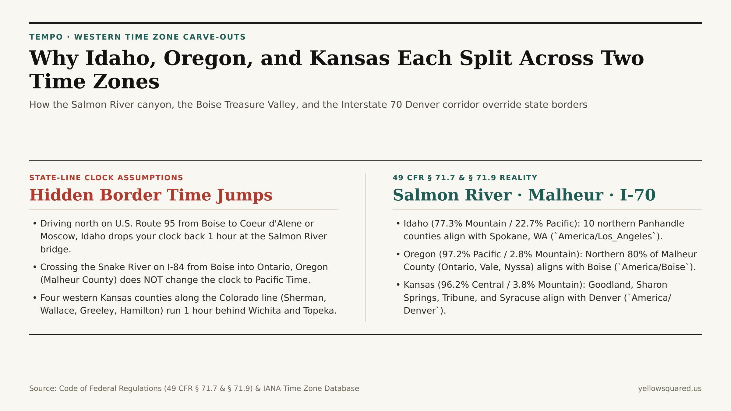
Look at a time zone map of the western United States and three state lines immediately break ranks with their neighbors: northern Idaho detaches from Boise to join Seattle and Spokane on Pacific Time; one county in eastern Oregon detaches from Portland to join Boise on Mountain Time; and four counties along the western edge of Kansas detach from Wichita to join Denver on Mountain Time. Each of these cross-state splits is codified in federal law under Title 49, Part 71 of the Code of Federal Regulations (49 CFR § 71.7 and § 71.9).

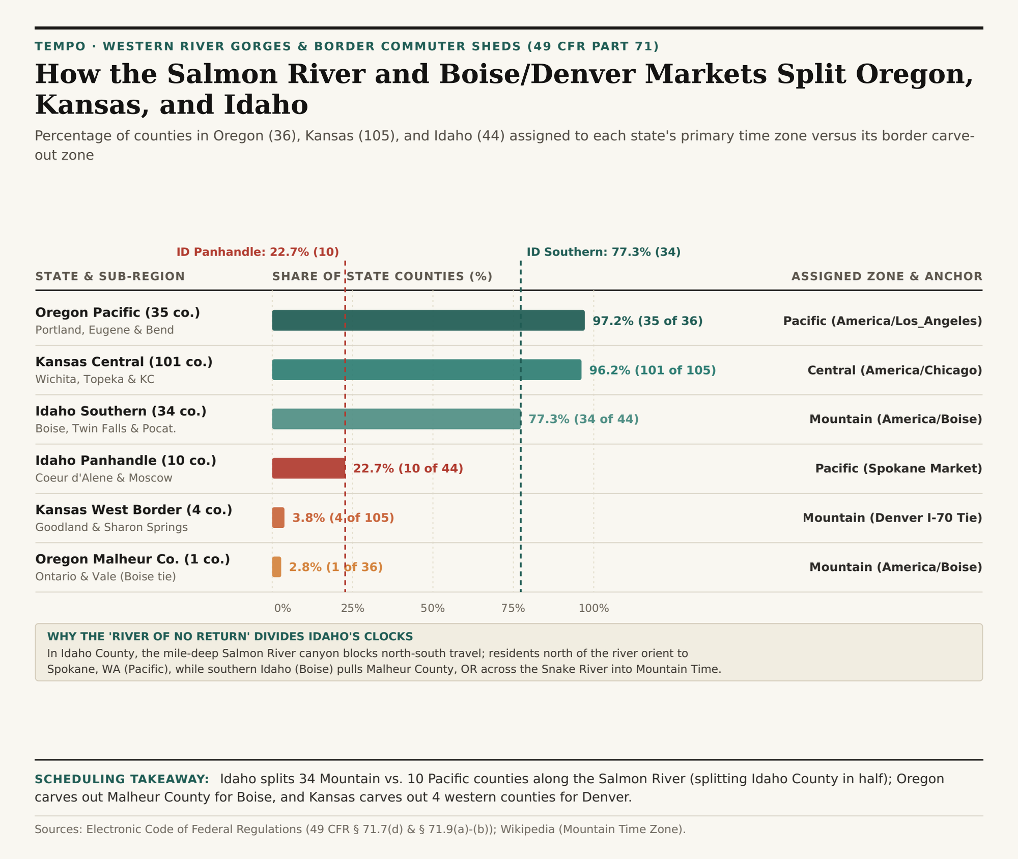
Across the three states, the U.S. Department of Transportation assigns 34 of Idaho's 44 counties (77.3%) to Mountain Time and 10 northern Panhandle counties (22.7%) to Pacific Time; 35 of Oregon's 36 counties (97.2%) to Pacific Time and Malheur County (2.8%) to Mountain Time; and 101 of Kansas's 105 counties (96.2%) to Central Time alongside 4 Colorado-border counties (3.8%) on Mountain Time. To check live clock offsets across any of these split-state corridors right now, Open Tempo in your browser.

Comparison between state-line clock assumptions and the statutory 49 CFR Part 71 time zone splits in Idaho, Oregon, and Kansas
Under 49 CFR § 71.7 and § 71.9, northern Idaho's 10 Panhandle counties align with Spokane (Pacific Time), Oregon's Malheur County aligns with Boise (Mountain Time), and four western Kansas counties align with Denver (Mountain Time).

1. Why the Salmon River Splits Idaho (and Divides Idaho County in Half)

Under 49 CFR § 71.9(b) and documented in Mountain Time Zone Statutory Boundary Records, the dividing line between Mountain Time (America/Boise) and Pacific Time (America/Los_Angeles) enters Idaho from the Montana border and follows the main channel of the Salmon River (famous as the "River of No Return") west to the Snake River canyon at the Oregon border.

The reason for this mid-state split is rugged topography and rail history. The Salmon River gorge cuts a mile-deep granite barrier across central Idaho; only a single winding two-lane highway (U.S. Route 95) links southern Idaho to the northern Panhandle. Because the 10 northern counties (Benewah, Bonner, Boundary, Clearwater, Kootenai, Latah, Lewis, Nez Perce, Shoshone, and the northern part of Idaho County) were settled via the transcontinental railroads running through Spokane, Washington — just 30 miles west of Coeur d'Alene — Congress and the DOT placed the entire northern Panhandle on Pacific Time (UTC-8 / PDT UTC-7). Remarkably, Idaho County is split in two by the river: its county seat of Grangeville sits north of the Salmon River on Pacific Time, while Riggins sits inside the canyon south of the bridge on Mountain Time.

Horizontal bar chart comparing the percentage of counties in Oregon, Kansas, and Idaho assigned to each state's primary time zone versus its border carve-out zone
County distribution across primary and border-exception time zones in Oregon (36 counties), Kansas (105 counties), and Idaho (44 counties). Download the 3-state county split dataset (CSV).

2. Why Oregon's Malheur County Runs on Boise Mountain Time

Cross the Snake River heading west on Interstate 84 from southern Idaho into Ontario, Oregon, and you might expect your clock to drop back an hour from Mountain Time to Pacific Time. Instead, the clock stays on Mountain Time for another 60 miles. Under 49 CFR § 71.9(a), the northern four-fifths of Malheur County, Oregon (north of latitude 42°27'N, encompassing Ontario, Vale, Nyssa, and Adrian) is legally assigned to Mountain Time (America/Boise). Because Ontario sits on the western edge of the irrigated Treasure Valley agricultural basin — where farmers, hospitals, television stations, and retail commuters all anchor to Boise, Nampa, and Caldwell — keeping Malheur County on Mountain Time prevents a daily clock jump across the Snake River bridges.

"Only the sparsely populated southern tip of Malheur County (around McDermitt on the Nevada border) drops back to Pacific Time, making Malheur County one of the few counties in the United States split between two time zones by a line of latitude."

3. Kansas's Four Interstate 70 Mountain Time Counties

In Kansas, 49 CFR § 71.7(d) places 101 of the state's 105 counties (96.2%) on Central Time (America/Chicago), even though the western half of Kansas lies west of the 97.5°W solar meridian. However, four counties stacked along the Colorado border — Sherman (Goodland), Wallace (Sharon Springs), Greeley (Tribune), and Hamilton (Syracuse) — petitioned to remain on Mountain Time (America/Denver) so their grain elevators, hospitals, and broadcast markets stay synchronized with eastern Colorado and Denver along the Interstate 70 and U.S. Route 50 corridors.

State & Sub-Region 49 CFR Part 71 Boundary Counties State Share Observed Time Zone Primary Metro / Market Anchor
Oregon Pacific Majority All except northern Malheur Co. 35 of 36 97.2% Pacific (UTC-8 / UTC-7) Portland, Eugene, Bend & Medford
Oregon Malheur Carve-Out Malheur Co. north of 42.45°N 1 of 36 2.8% Mountain (UTC-7 / UTC-6) Ontario, Vale & Boise Treasure Valley
Kansas Central Majority East of Sherman/Wallace/Greeley/Hamilton 101 of 105 96.2% Central (UTC-6 / UTC-5) Wichita, Topeka & Kansas City
Kansas Western Border Sherman, Wallace, Greeley, Hamilton 4 of 105 3.8% Mountain (UTC-7 / UTC-6) Goodland, Syracuse & Denver I-70 Corridor
Idaho Southern Majority South of Salmon River (49 CFR 71.9b) 34 of 44 77.3% Mountain (UTC-7 / UTC-6) Boise, Twin Falls, Idaho Falls & Pocatello
Idaho Northern Panhandle North of Salmon River canyon 10 of 44 22.7% Pacific (UTC-8 / UTC-7) Coeur d'Alene, Moscow & Spokane WA

Checking County-Level Clocks Before You Book

Whether you are coordinating a university call with Moscow, Idaho (Pacific) and Boise (Mountain), or scheduling freight stops along I-84 in Ontario, Oregon (Mountain) and I-70 in Goodland, Kansas (Mountain), city-level IANA lookups eliminate border guesswork. Open Tempo in your browser to compare live clocks across all three split states, and download the 49 CFR Part 71 county split CSV table.

039 / 56

Why Are North Dakota, South Dakota, and Nebraska Split Between Central and Mountain Time?

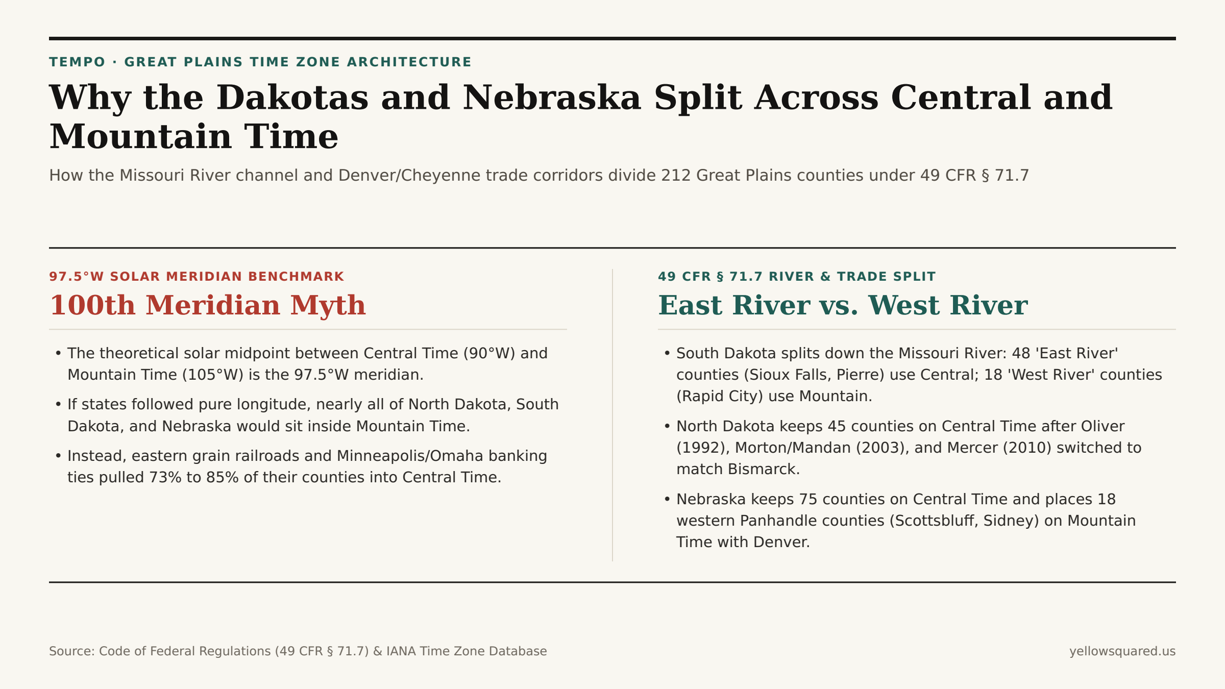
Look at a highway map of the northern Great Plains and the state borders of North Dakota, South Dakota, and Nebraska form three stacked horizontal rectangles. Yet their clocks refuse to follow state lines: under Title 49, Section 71.7 of the Code of Federal Regulations (49 CFR § 71.7), all three states are split between Central Time (UTC-6 / CDT UTC-5) in the east and Mountain Time (UTC-7 / MDT UTC-6) in the west.

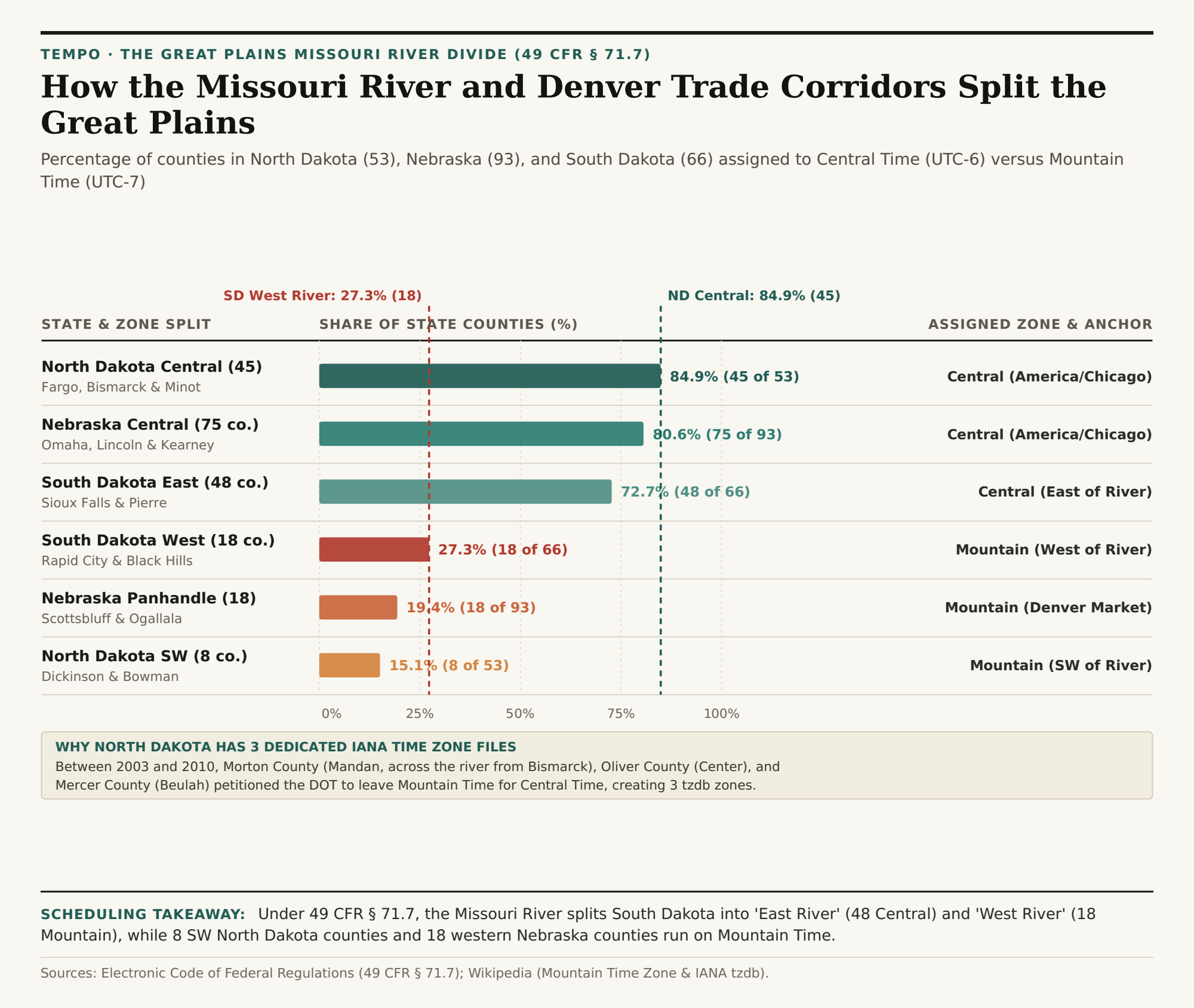
Across the 212 counties of the three states, federal commerce rules place 45 of North Dakota's 53 counties (84.9%) on Central Time vs. 8 southwest counties (15.1%) on Mountain Time; 48 of South Dakota's 66 counties (72.7%) on Central Time vs. 18 western counties (27.3%) on Mountain Time; and 75 of Nebraska's 93 counties (80.6%) on Central Time vs. 18 western Panhandle and southwest counties (19.4%) on Mountain Time. To check exact county-level UTC offsets before scheduling calls or freight across the Plains, Open Tempo in your browser.

Comparison between the 97.5 degree West solar meridian and the statutory 49 CFR 71.7 Missouri River and Panhandle time zone splits in North Dakota, South Dakota, and Nebraska
While the 97.5°W solar meridian runs down the eastern edge of the Dakotas and Nebraska, U.S. Department of Transportation boundaries push Central Time westward to the Missouri River and the Nebraska Panhandle.

1. South Dakota's "East River" vs. "West River" Cultural and Clock Divide

In South Dakota, the time zone boundary defined in 49 CFR § 71.7(b) and detailed in Mountain Time Zone Statutory Records follows the main channel of the Missouri River from the North Dakota border south to Pierre, then steps west around Lyman, Gregory, and Tripp counties to the Nebraska border. Residents use two everyday terms that simultaneously describe geography, ranching vs. farming economics, and clock time:

  • "East River" (48 Counties, 72.7% — Central Time, America/Chicago): Encompasses Sioux Falls, Aberdeen, Brookings, Mitchell, Yankton, and the state capital of Pierre (along with three counties immediately west of the river — Stanley, Lyman, and Gregory — that petitioned to stay on Central Time with Pierre and Chamberlain).
  • "West River" (18 Counties, 27.3% — Mountain Time, America/Denver): Encompasses Rapid City, Deadwood, Sturgis, Spearfish, the Black Hills, and the Badlands, aligning western South Dakota with Wyoming and Denver trade corridors.
Horizontal bar chart showing the percentage of counties in North Dakota, Nebraska, and South Dakota assigned to Central Time versus Mountain Time
County-level distribution between Central Time (UTC-6) and Mountain Time (UTC-7) across North Dakota, Nebraska, and South Dakota under 49 CFR § 71.7. Download the Great Plains county split dataset (CSV).

2. Why North Dakota Has Three Dedicated America/North_Dakota/* IANA Zones

In North Dakota, 49 CFR § 71.7(a) originally used the Missouri River as the dividing line between Central Time in the east (Fargo, Grand Forks, Minot, and Bismarck on the east bank) and Mountain Time in the southwest (Dickinson, Bowman, and Hettinger). However, because Bismarck sits directly on the east bank of the Missouri River, workers living just across the river in Mandan (Morton County) or in nearby coal and power-plant counties faced a daily one-hour time jump. Over an 18-year span, three county petitions redrew the boundary and forced the IANA Time Zone Database (tzdb) to create three dedicated historical zones:

  • America/North_Dakota/Center (Oliver County): Switched from Mountain Time to Central Time in October 1992.
  • America/North_Dakota/New_Salem (Morton County, except the far western strip): Switched from Mountain Time to Central Time in October 2003 so Mandan and New Salem matched neighboring Bismarck.
  • America/North_Dakota/Beulah (Mercer County): Switched from Mountain Time to Central Time in November 2010, leaving only 8 southwest counties (Adams, Billings, Bowman, Golden Valley, Hettinger, Slope, Stark, and south-bank McKenzie/Dunn/Sioux segments) on Mountain Time.

"Because Mandan and Bismarck sit on opposite banks of the Missouri River, Morton County's 2003 DOT petition eliminated a one-hour clock jump across a two-mile commuter bridge."

3. Nebraska's 75 Central vs. 18 Mountain Panhandle Split

In Nebraska, 49 CFR § 71.7(c) places 75 eastern and central counties (80.6%) — including Omaha, Lincoln, Grand Island, Kearney, and North Platte — on Central Time (America/Chicago). The western boundary steps down the western edges of Cherry (partially split), Thomas, McPherson, Lincoln, Hayes, and Hitchcock counties, placing 18 western Panhandle and southwest counties (19.4%, including Scottsbluff, Alliance, Sidney, Chadron, and Ogallala) on Mountain Time (America/Denver) so their agricultural, hospital, and broadcast schedules match nearby Cheyenne, Wyoming, and Front Range Colorado.

State & Sub-Region 49 CFR § 71.7 Boundary Counties State Share Observed Time Zone Primary Commercial Anchor
North Dakota Central East/North of Missouri + 3 counties 45 of 53 84.9% Central (UTC-6 / UTC-5) Fargo, Bismarck, Grand Forks & Minot
North Dakota Southwest Southwest of Missouri River 8 of 53 15.1% Mountain (UTC-7 / UTC-6) Dickinson, Bowman & Badlands
Nebraska Central East of Keith/Perkins/Chase line 75 of 93 80.6% Central (UTC-6 / UTC-5) Omaha, Lincoln, Kearney & North Platte
Nebraska Panhandle 18 Western Counties (49 CFR 71.7c) 18 of 93 19.4% Mountain (UTC-7 / UTC-6) Scottsbluff, Sidney, Alliance & Ogallala
South Dakota East River East of Missouri River channel 48 of 66 72.7% Central (UTC-6 / UTC-5) Sioux Falls, Aberdeen & Pierre
South Dakota West River West of Missouri River 18 of 66 27.3% Mountain (UTC-7 / UTC-6) Rapid City, Deadwood & Black Hills

Coordinating Schedules Across Interstate 80, I-90, and I-94

Long-haul drivers and logistics planners crossing the Great Plains on I-94 (near Dickinson, ND), I-90 (at the Missouri River bridge near Chamberlain, SD), or I-80 (between North Platte and Ogallala, NE) cross the Central-to-Mountain boundary mid-state. Open Tempo in your browser to check live local times across every county along your route, and download the 49 CFR § 71.7 Great Plains county split CSV.

040 / 56

Why Are Florida, Michigan, and Texas Split Across Two Time Zones?

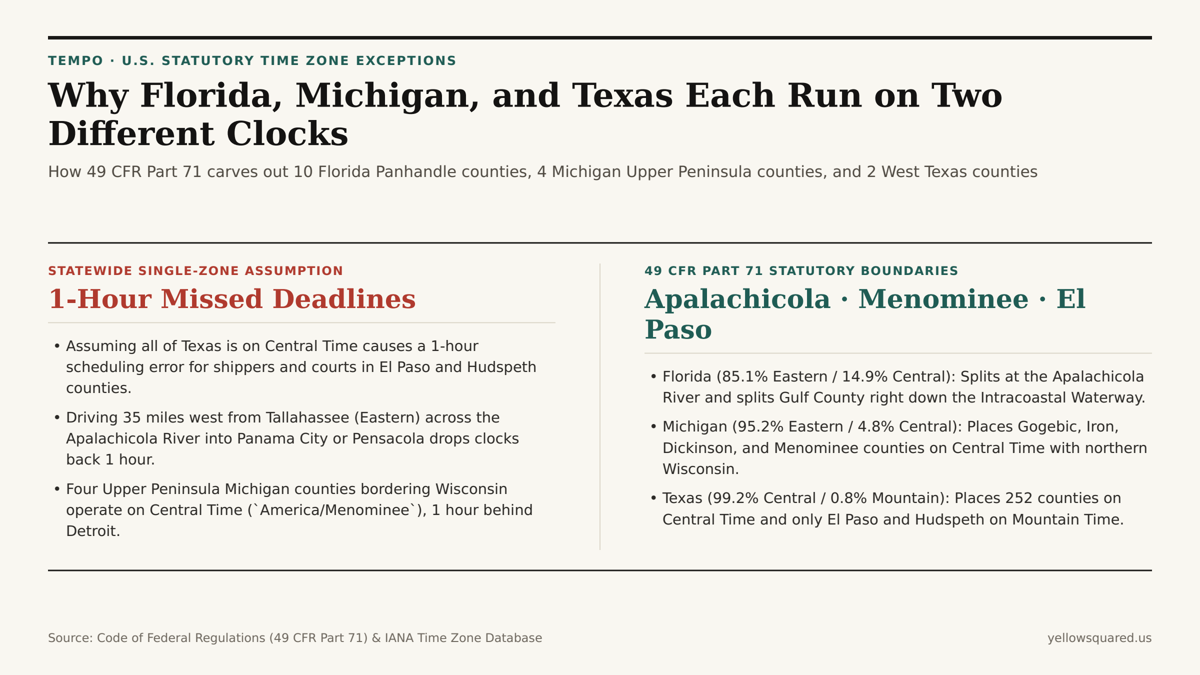
Ask most travelers which time zone governs Florida, Michigan, or Texas, and you will hear a confident one-word answer: Eastern for Florida and Michigan, Central for Texas. Yet under federal law — specifically Title 49, Part 71 of the Code of Federal Regulations (49 CFR Part 71) administered by the U.S. Department of Transportation — all three states are legally split across two time zones to prevent border cities and river basins from operating an hour apart from their nearest metropolitan neighbors.

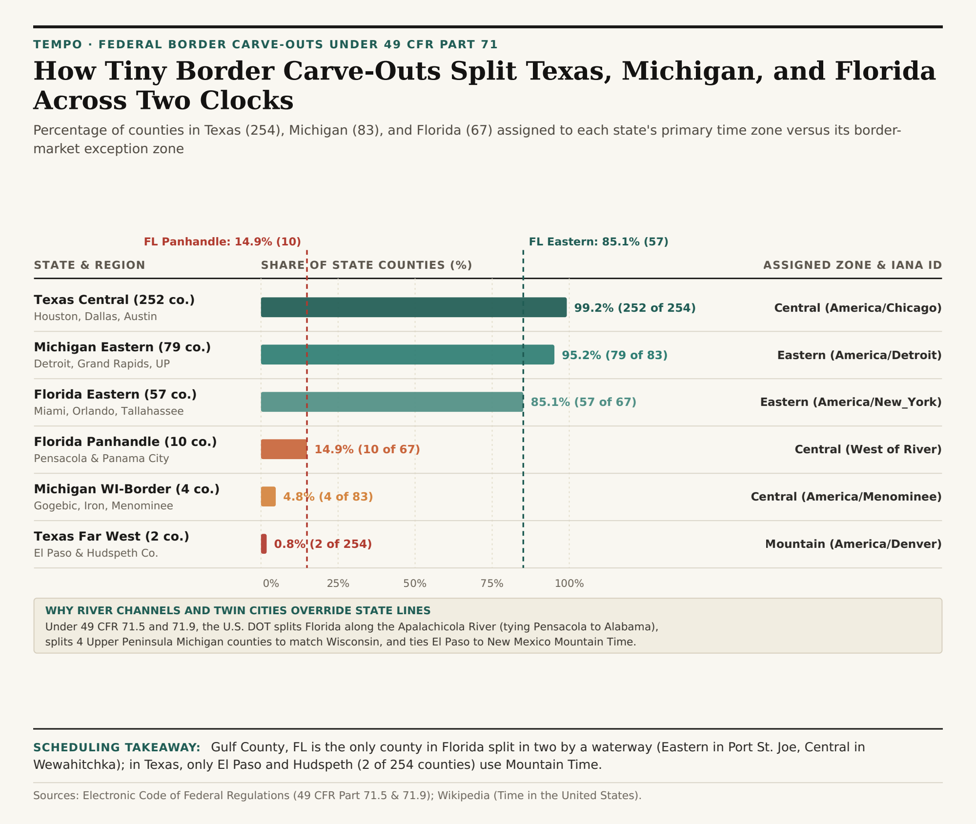
Across the three states, these federal commerce carve-outs place 10 of Florida's 67 counties (14.9%) on Central Time instead of Eastern Time, 4 of Michigan's 83 counties (4.8%) on Central Time instead of Eastern Time, and 2 of Texas's 254 counties (0.8%) on Mountain Time instead of Central Time. Even more remarkably, one county in the Florida Panhandle (Gulf County) is split directly in half along the Intracoastal Waterway. To inspect live clock offsets across split-state counties before booking travel or freight deliveries, Open Tempo in your browser.

Comparison between single-zone state assumptions and the statutory 49 CFR Part 71 county time zone splits in Florida, Michigan, and Texas
Under 49 CFR Part 71, 10 western Florida Panhandle counties, 4 Upper Peninsula Michigan counties bordering Wisconsin, and 2 far-west Texas counties operate one hour behind the rest of their state.

1. Florida's Apalachicola River Divide (57 Eastern vs. 10 Central Counties)

Under 49 CFR § 71.5(f) and documented in U.S. Department of Transportation Time Zone Boundary Records, the boundary between Eastern Time (America/New_York) and Central Time (America/Chicago) enters north Florida along the western border of Gadsden County (keeping the state capital of Tallahassee on Eastern Time) and follows the Apalachicola River south toward the Gulf of Mexico.

  • The 57 Eastern Time Counties (85.1%): All of peninsular Florida (Miami, Tampa, Orlando, Jacksonville) plus Tallahassee and the Big Bend region east of the Apalachicola River observe Eastern Time (UTC-5 / EDT UTC-4).
  • The 9 Whole Central Time Counties (13.4%): Jackson, Calhoun, Liberty (west of the river), Bay (Panama City), Washington, Holmes, Walton, Okaloosa, Santa Rosa, and Escambia (Pensacola) observe Central Time (UTC-6 / CDT UTC-5) because their daily commuter, hospital, and television markets tie directly into southern Alabama (Mobile–Pensacola DMA).
  • Gulf County — The Only Split County in Florida: When the boundary reaches Gulf County near the coast, 49 CFR § 71.5 routes the line along the Gulf Intracoastal Waterway and precision latitude 29°57'03.16"N. The coastal seat of Port St. Joe (32456) runs on Eastern Time, while northern Gulf County around Wewahitchka (32465) runs on Central Time — meaning county offices and schools within the same county operate on two different clocks.
Horizontal bar chart comparing the share of counties in Texas, Michigan, and Florida assigned to each state's primary time zone versus its border carve-out zone
County distribution across primary and border-exception time zones in Texas (254 counties), Michigan (83 counties), and Florida (67 counties). Download the 3-state county split dataset (CSV).

2. Michigan's Four Wisconsin-Border Counties (America/Menominee)

Michigan's Lower Peninsula lies geographically west of the 82.5°W solar meridian, which placed Detroit on Central Time until Detroit petitioned to join Eastern Time in 1915 (codified statewide in 1967–1973). However, four counties along the southwestern edge of Michigan's Upper Peninsula — Gogebic, Iron, Dickinson, and Menominee counties (4.8% of Michigan's 83 counties) — share landline exchanges, hospitals, and river bridges with twin cities in northern Wisconsin (such as Marinette, Wisconsin, directly across the Menominee River from Menominee, Michigan). Under 49 CFR § 71.5(a), those four counties remain on Central Time under the dedicated IANA identifier America/Menominee while the other 11 Upper Peninsula counties (including Marquette and Sault Ste. Marie) observe Eastern Time (America/Detroit).

3. Texas's El Paso & Hudspeth Mountain Time Carve-Out (252 vs. 2 Counties)

Spanning more than 800 miles from the Sabine River (93.5°W) to the Rio Grande bend at El Paso (106.6°W), Texas keeps 252 of its 254 counties (99.2%) on Central Time (America/Chicago). Under 49 CFR § 71.9, only two far-west Trans-Pecos counties — El Paso County and Hudspeth County (0.8%) — are assigned to Mountain Time (America/Denver, UTC-7 / MDT UTC-6). Because El Paso (population ~865,000) forms a contiguous border metropolis with Las Cruces, New Mexico (America/Denver) and Ciudad Juárez, Mexico, placing El Paso on Mountain Time prevents a one-hour jump across the New Mexico state line four miles from downtown.

"Drive east from El Paso on Interstate 10 and you cross from Mountain Time into Central Time at the Culberson County line — jumping ahead one full hour while still more than 500 miles west of Austin and San Antonio."

State & Sub-Region 49 CFR Part 71 Boundary Counties State Share Observed Time Zone IANA Identifier
Texas Central Majority East of Hudspeth/Culberson line 252 of 254 99.2% Central (UTC-6 / UTC-5) America/Chicago
Texas Far West El Paso & Hudspeth (49 CFR 71.9) 2 of 254 0.8% Mountain (UTC-7 / UTC-6) America/Denver
Michigan Eastern Majority Lower Peninsula + 11 UP counties 79 of 83 95.2% Eastern (UTC-5 / UTC-4) America/Detroit
Michigan WI-Border UP Gogebic, Iron, Dickinson, Menominee 4 of 83 4.8% Central (UTC-6 / UTC-5) America/Menominee
Florida Peninsula & East East of Apalachicola River 57 of 67 85.1% Eastern (UTC-5 / UTC-4) America/New_York
Florida Western Panhandle West of Apalachicola / Waterway 10 of 67 14.9% Central (UTC-6 / UTC-5) America/Chicago

Checking Split-State Clocks Before Scheduling

Whenever your team books meetings or freight pickups in Pensacola (Central), Iron Mountain (Central), or El Paso (Mountain), relying on state-level time zone lookup tables will miscalculate arrival windows by a full hour. Open Tempo in your browser to compare exact city-level IANA clocks side by side, and download the 49 CFR Part 71 county split CSV dataset.