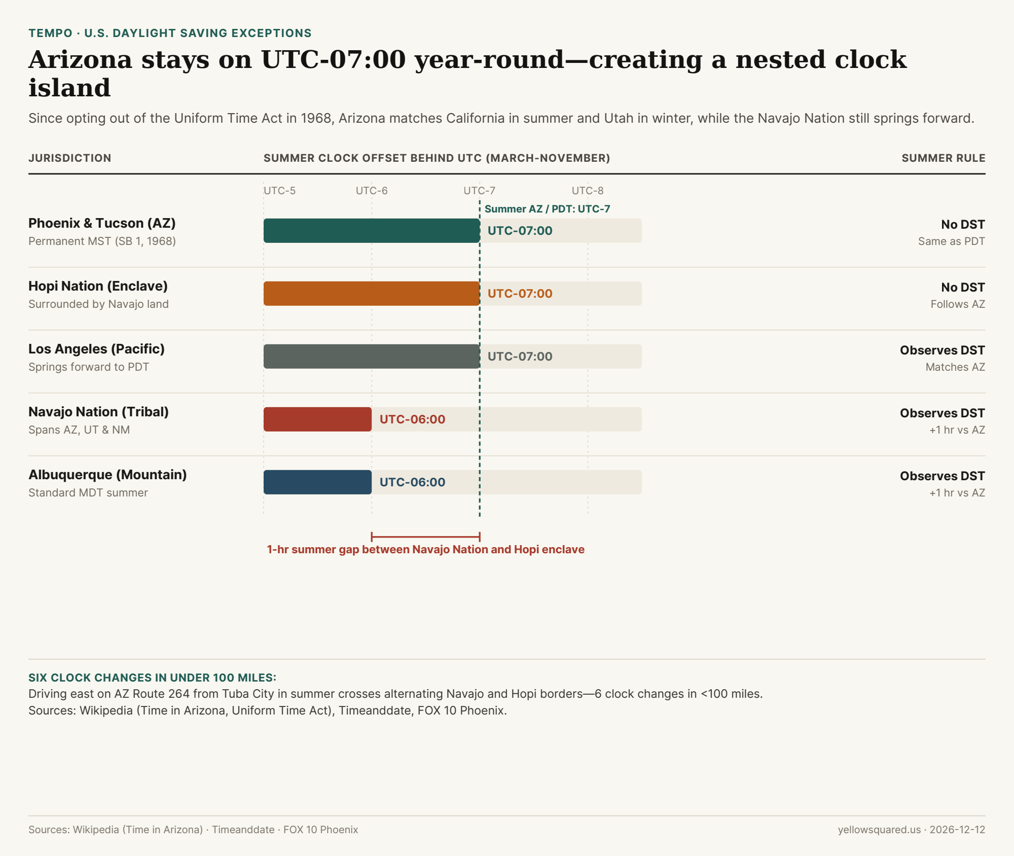
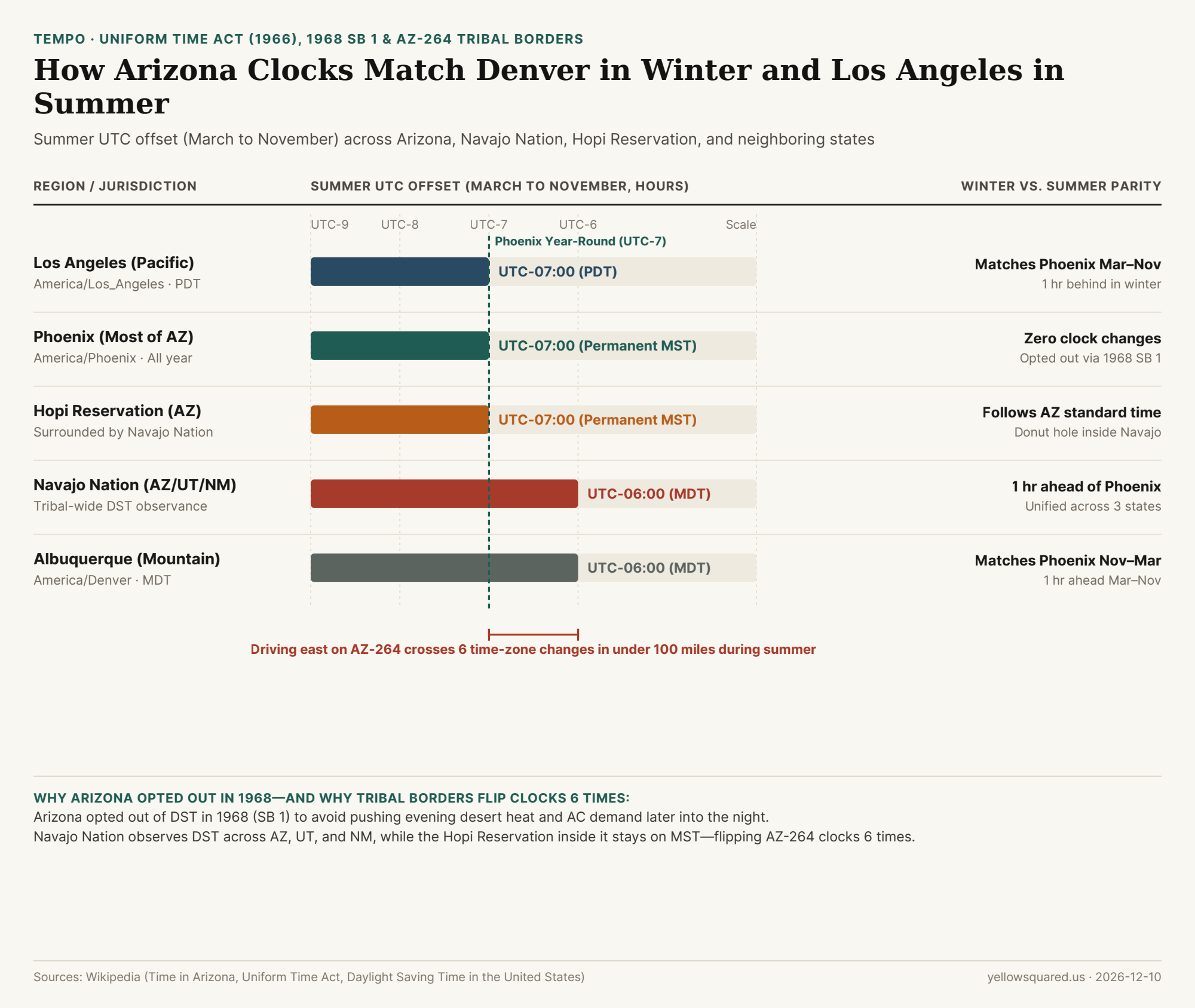
Every March and November, while nearly the entire United States springs forward and falls back, most of Arizona leaves its clocks untouched on Mountain Standard Time (UTC-07:00). As a result, Phoenix shares the exact same time as Los Angeles (Pacific Daylight Time) from March to November, then matches Denver and Albuquerque (Mountain Standard Time) from November to March.
Summer clock offsets (March–November) showing how Arizona's permanent UTC-07:00 aligns with California while diverging from the Navajo Nation. Data: Download CSV.
Why Arizona Opted Out in 1968
When Congress passed the Uniform Time Act of 1966, Arizona tried Daylight Saving Time once in 1967. According to Wikipedia's Time in Arizona records and Arizona State Historian Marshall Trimble, pushing summer sunsets past 9:00 PM kept air conditioners running longer during peak evening heat and hurt drive-in theaters and restaurants. On March 21, 1968, the Arizona legislature passed SB 1 to keep the state on Mountain Standard Time year-round.
"Traveling east on Arizona State Route 264 from Tuba City during DST involves six time zone changes in less than 100 miles." — Time in Arizona, Wikipedia
The Navajo and Hopi Clock Donut Hole
Because tribal nations set their own clock rules, the Navajo Nation—whose territory extends into Utah and New Mexico—observes Daylight Saving Time to keep a single schedule across its reservation. However, the Hopi Reservation, an enclave completely surrounded by the Navajo Nation inside Arizona, follows Arizona's no-DST rule. From March to November, driving across northeastern Arizona jumps back and forth between UTC-07:00 and UTC-06:00 six times in under 100 miles.
To check whether Phoenix matches Los Angeles or Denver on any date of the year before sending a calendar invite, Open Tempo in your browser.
Most people use Greenwich Mean Time (GMT) and Coordinated Universal Time (UTC) as interchangeable labels for 0° longitude, yet they measure two fundamentally different physical systems. GMT—modernized in astronomy as UT1—is tied to the irregular spin of the Earth, while UTC is generated by a global weighted average of cesium-133 atomic clocks and hydrogen masers maintained by the Bureau International des Poids et Mesures (BIPM).
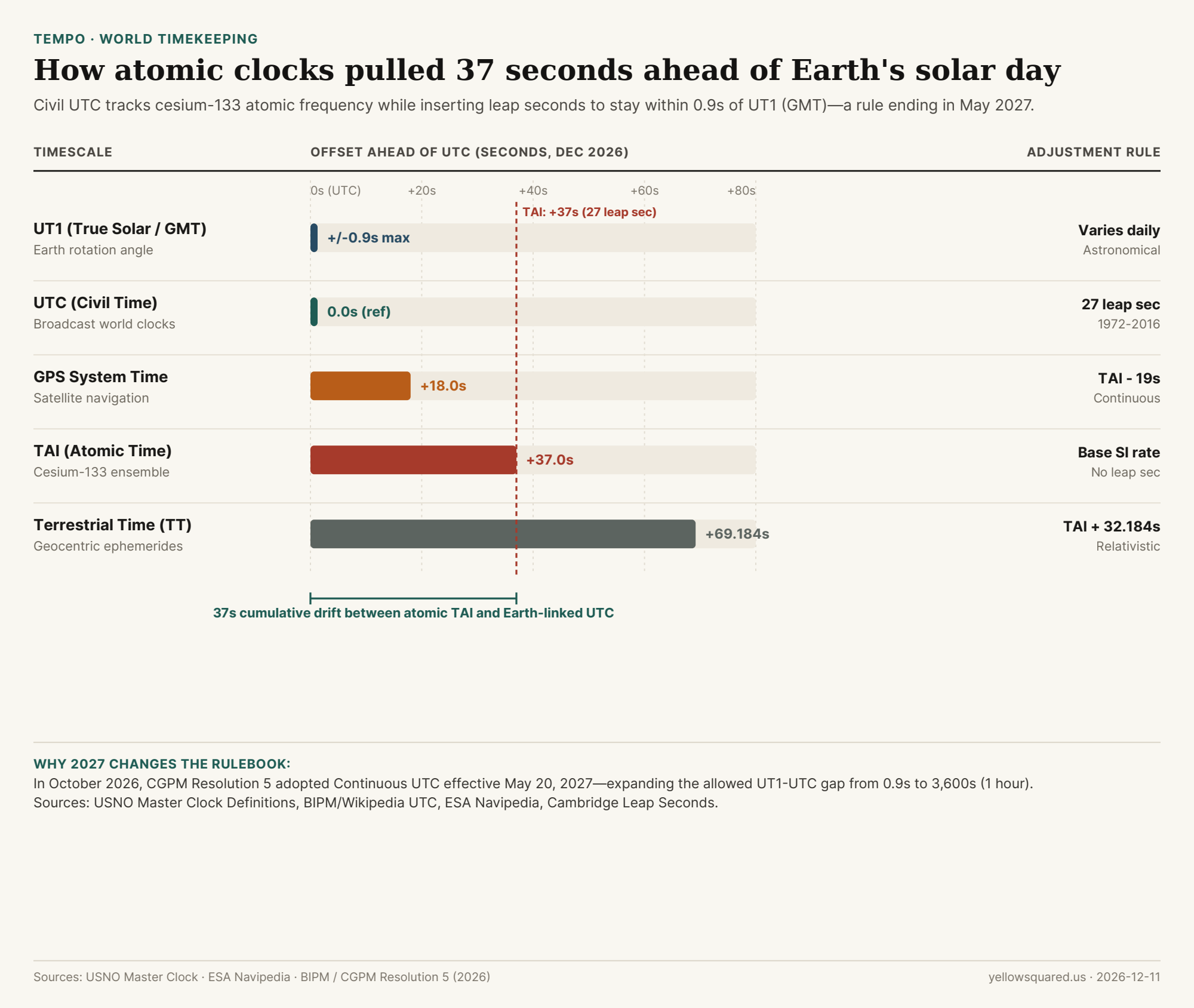
Cumulative offset in seconds between civil UTC and major atomic or astronomical timescales as of December 2026. Data: Download CSV.
Why Earth's Rotation and Atomic Clocks Diverged
In 1958, when International Atomic Time (TAI) was initialized, it was set equal to GMT. However, the U.S. Naval Observatory (USNO) notes that the SI atomic second is fixed at exactly 9,192,631,770 radiation cycles of cesium-133, whereas Earth's mean solar day fluctuates due to tidal friction, seasonal mass transport, and core-mantle dynamics.
To keep broadcast clocks aligned with daylight without altering the length of the SI second, the International Radio Consultative Committee introduced leap seconds in 1972. Under ITU-R Recommendation TF.460, the International Earth Rotation and Reference Systems Service (IERS) inserts a positive 1-second step whenever needed to keep UTC within 0.9 seconds of UT1.
"Coordinated Universal Time (UTC) differs from TAI by an integral number of seconds... UTC has replaced Greenwich Mean Time (GMT) as an international standard." — U.S. Naval Observatory, Definitions of Systems of Time
How the Major Timescales Compare Today
Because leap seconds are applied to civil UTC—and never to pure atomic or satellite timescales—different engineering systems now sit dozens of seconds apart, as documented by University of Cambridge timekeeping records and ESA Navipedia:
Timescale
Offset vs. UTC (Dec 2026)
Physical Basis
Leap Second Handling
UT1 (True GMT)
Within ±0.9s
Mean solar time at 0° longitude
Continuous Earth rotation
UTC (Civil Standard)
0.0s (Reference)
TAI + integral steps
27 positive leap seconds (1972–2016)
GPS System Time
+18.0s
TAI minus 19.0s fixed
Continuous; ignores post-1980 leap seconds
TAI (Atomic Time)
+37.0s
~250 cesium clocks & masers
Continuous; never adjusted
Terrestrial Time (TT)
+69.184s
TAI + 32.184s on Earth's geoid
Continuous astronomical ephemeris
What Changes on May 20, 2027
Because Earth's rotation temporarily accelerated after 2015, no leap second has been required since December 31, 2016. More importantly, server outages caused by rare 23:59:60 timestamps pushed standards bodies to retire the mechanism. Following the 27th General Conference on Weights and Measures (CGPM) in 2022, Resolution 5 of the 28th CGPM (October 2026) formally established Continuous UTC effective May 20, 2027—raising the maximum allowed |UT1 - UTC| drift from 0.9 seconds to 3,600 seconds (1 hour) so civil clocks can run uninterrupted for centuries.
When coordinating meetings across UTC offsets, standard time zones, and daylight saving transitions without manual arithmetic, Open Tempo in your browser to convert live local times worldwide.
003 / 56
Why Does Arizona Not Observe Daylight Saving Time (Except the Navajo Nation)?
Along with Hawaii and five U.S. territories, Arizona is one of only two U.S. states that does not change its clocks twice a year. Since 1968, most of Arizona (America/Phoenix) has remained permanently on Mountain Standard Time (UTC-07:00)—meaning Phoenix shares the same clock time as Albuquerque and Denver from November to March, then matches Los Angeles and Seattle (PDT, UTC-07:00) from March to November.
When Congress passed the Uniform Time Act of 1966, states were allowed to exempt themselves by passing a statewide law. Arizona briefly tried DST in 1967, then passed Senate Bill 1 on March 21, 1968, locking the state onto permanent Mountain Standard Time:
Desert Heat & Air Conditioning: In Phoenix and Tucson, pushing sunset an hour later in June and July keeps outdoor activities and peak cooling demand running later into the evening—increasing rather than reducing electricity use for air conditioning.
Seasonal Neighbor Parity: Because California and Nevada spring forward to UTC-07:00 on the second Sunday of March, Arizona automatically aligns with the West Coast all summer without touching a single clock.
"Traveling east on Arizona State Route 264 from Tuba City during Daylight Saving Time crosses six time-zone changes in less than 100 miles because Navajo Nation observes DST while Arizona and the Hopi Reservation do not."
The Navajo Nation and Hopi Reservation Donut Hole
Because the Navajo Nation spans northeastern Arizona, northwestern New Mexico, and southeastern Utah, tribal law applies Daylight Saving Time (UTC-06:00 in summer) across the entire reservation so government and schools stay on one clock. However, the Hopi Reservation—geographically enclaved inside the Arizona portion of the Navajo Nation—follows Arizona standard time (UTC-07:00). Driving AZ-264 in summer therefore flips your car clock back and forth six times in under 100 miles.
Look at a time-zone map of the Middle East and one country stands right in the middle on its own 30-minute offset: Iran is the only country on Earth that observes UTC+03:30 (Iran Standard Time, IRST, IANA identifier Asia/Tehran). That places clocks in Tehran 30 minutes ahead of neighboring Iraq, Turkey, and Saudi Arabia (UTC+03:00) and 30 minutes behind the United Arab Emirates, Oman, and Armenia (UTC+04:00).
As documented in Iran Standard Time, UTC+03:30, and Iranian calendars, that half-hour offset is not random: it is anchored to the exact 52.5°E astronomical meridian—the official meridian of Iran that also determines the exact instant of the spring equinox (Nowruz) in the Solar Hijri calendar. Open Tempo in your browser to compare Asia/Tehran (UTC+03:30) with neighboring Middle Eastern, European, and North American time zones.
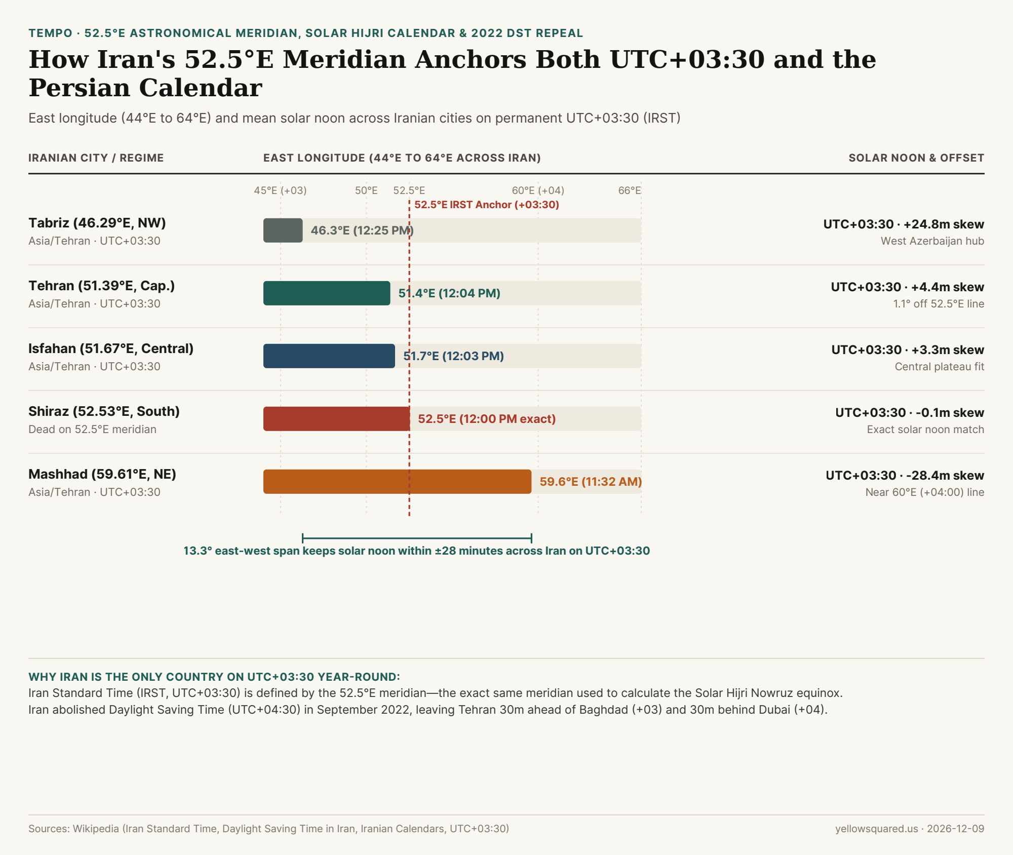
In standard 15-degree solar geometry, UTC+03:00 is centered on 45°E (western Iran/Iraq border) and UTC+04:00 is centered on 60°E (eastern Iran/Afghanistan border). Halfway between them lies 52.50°E—which passes almost directly down the center of the Iranian plateau:
Tehran (51.39°E): Sits just 1.11° west of 52.50°E, giving the capital a mean solar noon of 12:04 PM (+4.4 minutes skew).
Isfahan (51.67°E) & Shiraz (52.53°E): Shiraz sits virtually dead on the 52.50°E meridian, where mean solar noon strikes at 12:00 PM (-0.1 minutes skew).
Tabriz (46.29°E) to Mashhad (59.61°E): Because 52.5°E splits the country's 13.3° east-west span right down the middle, solar noon stays within ±28 minutes of 12:00 PM from the Turkish border to Khorasan.
"The 52.5°E meridian does double duty in Iran: it anchors civil clocks to UTC+03:30—putting solar noon in Tehran at 12:04 PM—and serves as the official astronomical meridian for calculating the Solar Hijri New Year (Nowruz)."
Why Iran Abolished Daylight Saving Time (UTC+04:30) in 2022
1991–2005 & 2008–2022: Iran observed Iran Daylight Time (IRDT, UTC+04:30) from the start of spring (Farvardin 1 / March 21–22) until the end of summer (Shahrivar 30 / September 21–22), with a brief two-year pause in 2006–2007.
September 21, 2022 Repeal: Following legislation passed by Parliament and confirmed by the Guardian Council in May 2022, Iran abolished seasonal clock changes effective September 21, 2022, keeping the country on UTC+03:30 year-round (though local administrative schedule experiments were briefly debated in Tehran in May 2025).
Iranian Cities Solar Noon & Offset Table
The table below details east longitude, official IANA offset, and mean solar noon across Iran (download the raw CSV dataset):
City or Historical Regime
IANA TZDB Zone
East Longitude
UTC Offset
Mean Solar Noon
Solar Skew
Regional Context
Tabriz (Northwest)
Asia/Tehran
46.29°E
UTC+03:30
12:25 PM
+24.8 min
Near 45°E (UTC+03:00) border with Turkey & Iraq
Tehran (Capital)
Asia/Tehran
51.39°E
UTC+03:30
12:04 PM
+4.4 min
1.11° west of 52.5°E; permanent standard time since 2022
Isfahan (Central)
Asia/Tehran
51.67°E
UTC+03:30
12:03 PM
+3.3 min
Central Iranian plateau alignment
Shiraz (South)
Asia/Tehran
52.53°E
UTC+03:30
12:00 PM
-0.1 min
Sits dead on the 52.50°E meridian
Mashhad (Northeast)
Asia/Tehran
59.61°E
UTC+03:30
11:32 AM
-28.4 min
Near 60°E (UTC+04:00) eastern border
Tehran (2008–2022 DST)
Asia/Tehran (IRDT)
51.39°E
UTC+04:30 (Repealed)
1:04 PM
+64.4 min
Abolished effective Sept 21, 2022
Global Scheduling Tip for Asia/Tehran
Because Iran ended DST in 2022 while Europe and North America still shift clocks twice a year, the time difference between Tehran and Western cities now changes twice annually: Tehran is +3h 30m ahead of London in winter (GMT) and +2h 30m ahead in summer (BST), and +8h 30m ahead of New York in winter vs. +7h 30m in summer. Open Tempo in your browser to track Asia/Tehran alongside your team's local clocks.
005 / 56
Why Is Newfoundland 30 Minutes Ahead of Atlantic Time (UTC-03:30)?
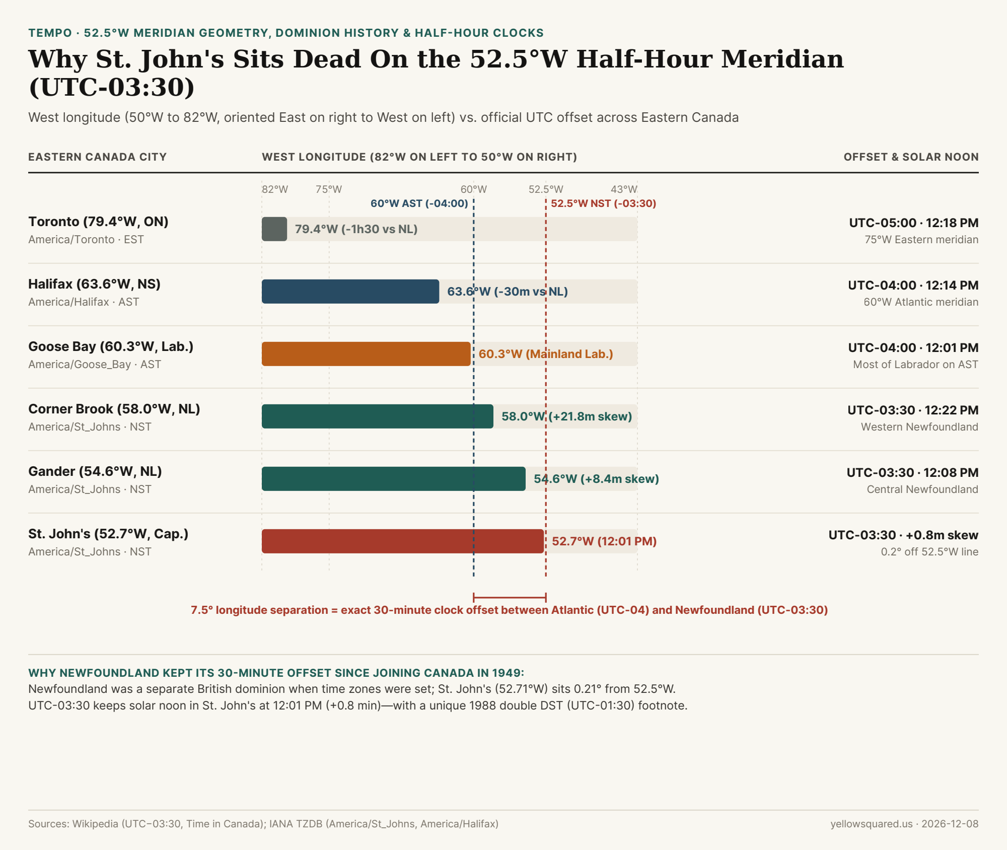
Anyone who has tuned into a Canadian television broadcast or scheduled a call across Atlantic Canada has heard the classic phrasing: "8:00 PM Eastern, 9:00 PM Atlantic, 9:30 in Newfoundland." While most of the world's time zones step in whole 1-hour (15°) increments from Coordinated Universal Time, the island of Newfoundland and the southeastern tip of Labrador observe Newfoundland Standard Time (NST, UTC−03:30, IANA identifier America/St_Johns) in winter and Newfoundland Daylight Time (NDT, UTC−02:30) in summer—exactly 30 minutes ahead of Nova Scotia, New Brunswick, and Prince Edward Island.
Why does Canada's easternmost province run on a half-hour offset? As documented in UTC−03:30 and Time in Canada, the answer combines precise 52.5°W solar meridian geometry with Newfoundland's history as a separate self-governing British dominion before it joined Confederation in 1949. Open Tempo in your browser to check live America/St_Johns clocks alongside Atlantic, Eastern, and European time zones.
Figure 1: West longitude (82°W left to 43°W right) and mean solar noon clock time across Eastern Canada, showing how St. John's (52.71°W) sits within 0.21° of the exact 52.5°W meridian for UTC−03:30. Sources: UTC−03:30 and Time in Canada · Download CSV dataset.
The 52.5°W Half-Hour Meridian Fit
Standard 1-hour time zones are centered on multiples of 15° longitude: Eastern Time (UTC−05:00) is anchored at 75°W, and Atlantic Time (UTC−04:00) is anchored at 60°W. The next whole-hour meridian eastward is 45°W (UTC−03:00, which crosses southern Greenland in the middle of the North Atlantic Ocean).
Look at where the island of Newfoundland sits: its eastern capital, St. John's, lies at 52°43'W (52.71°W)—almost dead halfway between 60°W and 45°W! Because 7.5° of longitude equals exactly 30 minutes of Earth rotation (7.5° × 4 min/° = 30 min), the exact theoretical meridian for UTC−03:30 is 52.50°W:
On UTC−03:30 (Newfoundland Standard Time): St. John's sits just 0.21° west of 52.50°W, placing mean solar noon at 12:01 PM (+0.8 minutes skew). Even Corner Brook on the western coast of the island (57.95°W) stays within 22 minutes of noon (12:22 PM).
Why It Survived Joining Canada in 1949: When standard time zones were established, Newfoundland was a separate British dominion rather than a Canadian province, so it chose the UTC−03:30 offset tailored to St. John's. After joining Canada in 1949, residents resisted proposals to adopt Atlantic Time (UTC−04:00), which would have pushed St. John's winter sunsets 30 minutes earlier.
"St. John's (52.71°W) sits just 0.21 degrees—less than one minute of solar time—from the exact 52.50°W reference meridian for UTC−03:30, making Newfoundland Time one of the most astronomically accurate half-hour time zones on Earth."
Labrador's Split & The 1988 "Double Daylight Saving Time" Footnote
As noted in Time in Canada, although the province's statutory name is Newfoundland and Labrador, the half-hour clock is not uniform across the mainland:
Island of Newfoundland + Southeastern Labrador: The entire island plus coastal communities from L'Anse-au-Clair to Norman Bay observe UTC−03:30 / UTC−02:30 (America/St_Johns).
Mainland Labrador (Happy Valley-Goose Bay & Labrador City): Most of Labrador sits around 60°W–67°W and observes Atlantic Time (UTC−04:00 / UTC−03:00, America/Goose_Bay) to stay synchronized with neighboring Quebec and the Maritimes.
The 1988 Double DST Experiment: From April 3 to October 30, 1988, Newfoundland famously experimented with "Double Daylight Saving Time", advancing clocks by 2 full hours to UTC−01:30 before returning to a standard 1-hour summer shift (UTC−02:30) in 1989.
Eastern Canada Solar Noon & Offset Table
The table below compares longitude, IANA identifiers, official offsets, and mean solar noon across Eastern Canada (download the raw CSV dataset):
City & Region
IANA TZDB Zone
West Longitude
Standard / DST Offset
Mean Solar Noon (Std)
Skew
Scheduling Difference vs. St. John's
St. John's (East NL)
America/St_Johns
52.71°W
UTC−03:30 / −02:30
12:01 PM
+0.8 min
Reference (0.21° from 52.5°W)
Gander (Central NL)
America/St_Johns
54.61°W
UTC−03:30 / −02:30
12:08 PM
+8.4 min
Same clock as St. John's
Corner Brook (West NL)
America/St_Johns
57.95°W
UTC−03:30 / −02:30
12:22 PM
+21.8 min
Same clock as St. John's
Goose Bay (Labrador)
America/Goose_Bay
60.31°W
UTC−04:00 / −03:00
12:01 PM
+1.2 min
30 minutes behind St. John's
Halifax (Nova Scotia)
America/Halifax
63.58°W
UTC−04:00 / −03:00
12:14 PM
+14.3 min
30 minutes behind St. John's
Toronto (Ontario)
America/Toronto
79.38°W
UTC−05:00 / −04:00
12:18 PM
+17.5 min
1 hour 30 minutes behind St. John's
Meeting & Travel Tip Across the 30-Minute Boundary
Because Newfoundland observes the same North American DST transition dates (second Sunday in March and first Sunday in November) as Atlantic and Eastern Time, its +30 minute lead over Halifax and +1h 30m lead over Toronto/New York stays constant year-round—unlike regions without DST. Open Tempo in your browser to lock America/St_Johns onto your world clock bar so you never miss a half-hour meeting offset.
006 / 56
Why Does the Democratic Republic of the Congo Have Two Time Zones (Kinshasa UTC+01:00 vs. Lubumbashi UTC+02:00)?
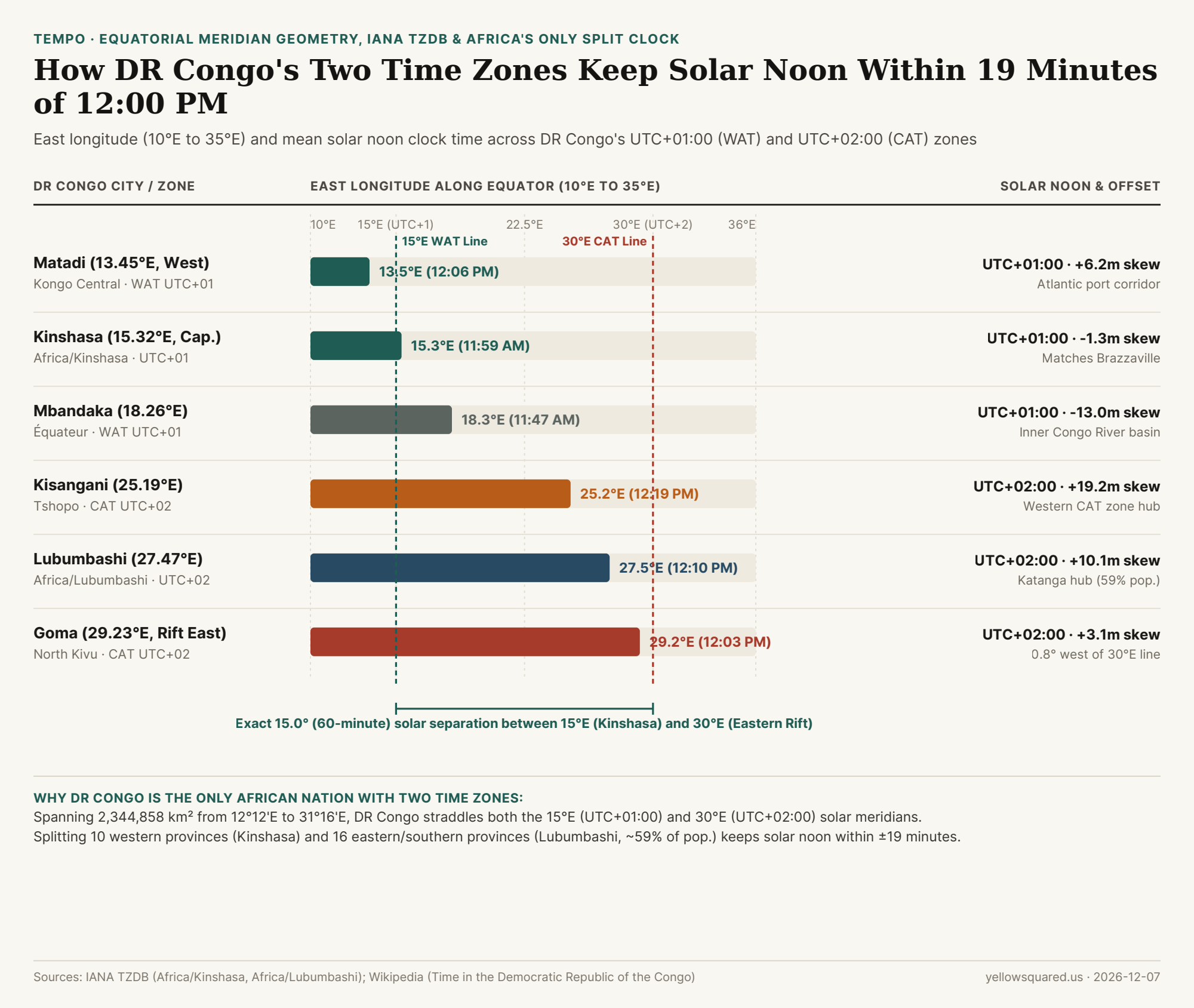
Look at a time-zone map of Africa and one country immediately stands out: the Democratic Republic of the Congo (DRC) is the only sovereign nation on the African continent that divides its territory into two standard time zones year-round. According to historical and legislative records summarized in Time in the Democratic Republic of the Congo, the country's 10 western provinces—including the national capital, Kinshasa—observe West Africa Time (WAT, UTC+01:00, IANA identifier Africa/Kinshasa), while its 16 eastern and southern provinces—including the copper-belt hub of Lubumbashi and the Great Lakes city of Goma—observe Central Africa Time (CAT, UTC+02:00, IANA identifier Africa/Lubumbashi), where roughly 59% of the Congolese population resides.
Why didn't the DRC merge into a single national clock like Algeria, Nigeria, or Kazakhstan? The answer lies in pure equatorial solar geometry: the DRC spans 2,344,858 km² from 12°12'E on the Atlantic coast to 31°16'E along Lake Albert—straddling the exact theoretical reference meridians for both UTC+01:00 (15°00'E) and UTC+02:00 (30°00'E). Open Tempo in your browser to compare live clocks between Africa/Kinshasa and Africa/Lubumbashi alongside your local time zone.
Figure 1: East longitude (12°E to 31°E) and mean solar noon clock time across the Democratic Republic of the Congo's western UTC+01:00 (Africa/Kinshasa) and eastern UTC+02:00 (Africa/Lubumbashi) time zones. Source: Time in the Democratic Republic of the Congo · Download CSV dataset.
The 15°E and 30°E Equatorial Meridian Fit
Because Earth rotates 360° in 24 hours, every 15° of east longitude corresponds to exactly 60 minutes of solar time (4.0 minutes per degree). Unlike high-latitude countries where seasonal daylight swings from 8 hours in winter to 16 hours in summer, the DRC sits squarely astride the Equator (between 5°N and 13°S), where day and night last roughly 12 hours each all year long and neither zone observes Daylight Saving Time.
"Kinshasa sits at 15°19'E—just 0.32 degrees (78 seconds of solar time) east of the exact 15°00'E reference meridian for UTC+01:00—while Goma on the eastern border sits at 29°14'E, just 0.77 degrees west of the 30°00'E reference meridian for UTC+02:00."
This geographic alignment produces one of the tightest solar-noon fits on Earth:
Western Zone (WAT, UTC+01:00, Africa/Kinshasa): Covers the 10 western provinces (Kinshasa, Kongo Central, Kwango, Kwilu, Mai-Ndombe, Équateur, Mongala, Nord-Ubangi, Sud-Ubangi, and Tshuapa). In Kinshasa (15.32°E), mean solar noon occurs at 11:59 AM (-1.3 minutes skew), keeping sunrise near 6:00 AM and sunset near 6:00 PM year-round. Crucially, staying on UTC+01:00 keeps Kinshasa synchronized with Brazzaville (15.28°E, Republic of the Congo) directly across the Congo River—the closest pair of national capitals in the world outside Rome/Vatican City.
Eastern & Southern Zone (CAT, UTC+02:00, Africa/Lubumbashi): Covers 16 provinces across Kasaï, Maniema, Katanga, Orientale/Tshopo, and North/South Kivu, home to roughly 59% of the national population. In Lubumbashi (27.47°E), solar noon falls at 12:10 PM (+10.1 minutes skew), while in Goma (29.23°E) it hits 12:03 PM (+3.1 minutes skew), matching neighboring Rwanda, Burundi, Zambia, and South Africa on UTC+02:00.
City-by-City Solar Noon & IANA TZDB Reference Table
The table below details the exact east longitude, IANA time-zone identifier, reference meridian, and mean solar noon clock time across six major Congolese cities (download the raw CSV table):
DRC City & Province
IANA TZDB Zone
Longitude
Official Offset
Mean Solar Noon
Solar Skew
Cross-Border & Regional Alignment
Matadi (Kongo Central)
Africa/Kinshasa
13.45°E
UTC+01:00 (WAT)
12:06 PM
+6.2 min
Atlantic port corridor; matches Angola (UTC+01:00)
Kinshasa (Capital)
Africa/Kinshasa
15.32°E
UTC+01:00 (WAT)
11:59 AM
-1.3 min
Sits on 15°E meridian; matches Brazzaville across river
Mbandaka (Équateur)
Africa/Kinshasa
18.26°E
UTC+01:00 (WAT)
11:47 AM
-13.0 min
Inner Congo River basin near the 0°00' Equator line
Kisangani (Tshopo)
Africa/Lubumbashi
25.19°E
UTC+02:00 (CAT)
12:19 PM
+19.2 min
Western hub of the UTC+02:00 zone along upper Congo River
Lubumbashi (Haut-Katanga)
Africa/Lubumbashi
27.47°E
UTC+02:00 (CAT)
12:10 PM
+10.1 min
Copper-belt capital; matches Zambia & South Africa (UTC+02:00)
Goma (North Kivu)
Africa/Lubumbashi
29.23°E
UTC+02:00 (CAT)
12:03 PM
+3.1 min
0.77° west of 30°E; matches Gisenyi, Rwanda across border
Domestic Flights and Scheduling Across the Kasaï Boundary
When booking domestic flights or coordinating teams between western and eastern Congo, remember that crossing the internal provincial boundary between Kwango/Mai-Ndombe (UTC+01:00) and Kasaï (UTC+02:00) shifts the clock by one full hour year-round. A 2-hour nonstop flight departing Kinshasa (FIH, UTC+01:00) at 08:00 WAT for Lubumbashi (FBM, UTC+02:00) lands at 11:00 CAT local time, whereas the return flight leaving Lubumbashi at 12:00 CAT lands in Kinshasa at 13:00 WAT. Open Tempo in your browser to pin both Africa/Kinshasa and Africa/Lubumbashi whenever you coordinate across Central Africa.
007 / 56
Why Does Mongolia Have Two Time Zones (UTC+07:00 and UTC+08:00), and Why Did It Abolish Daylight Saving Time in 2017?
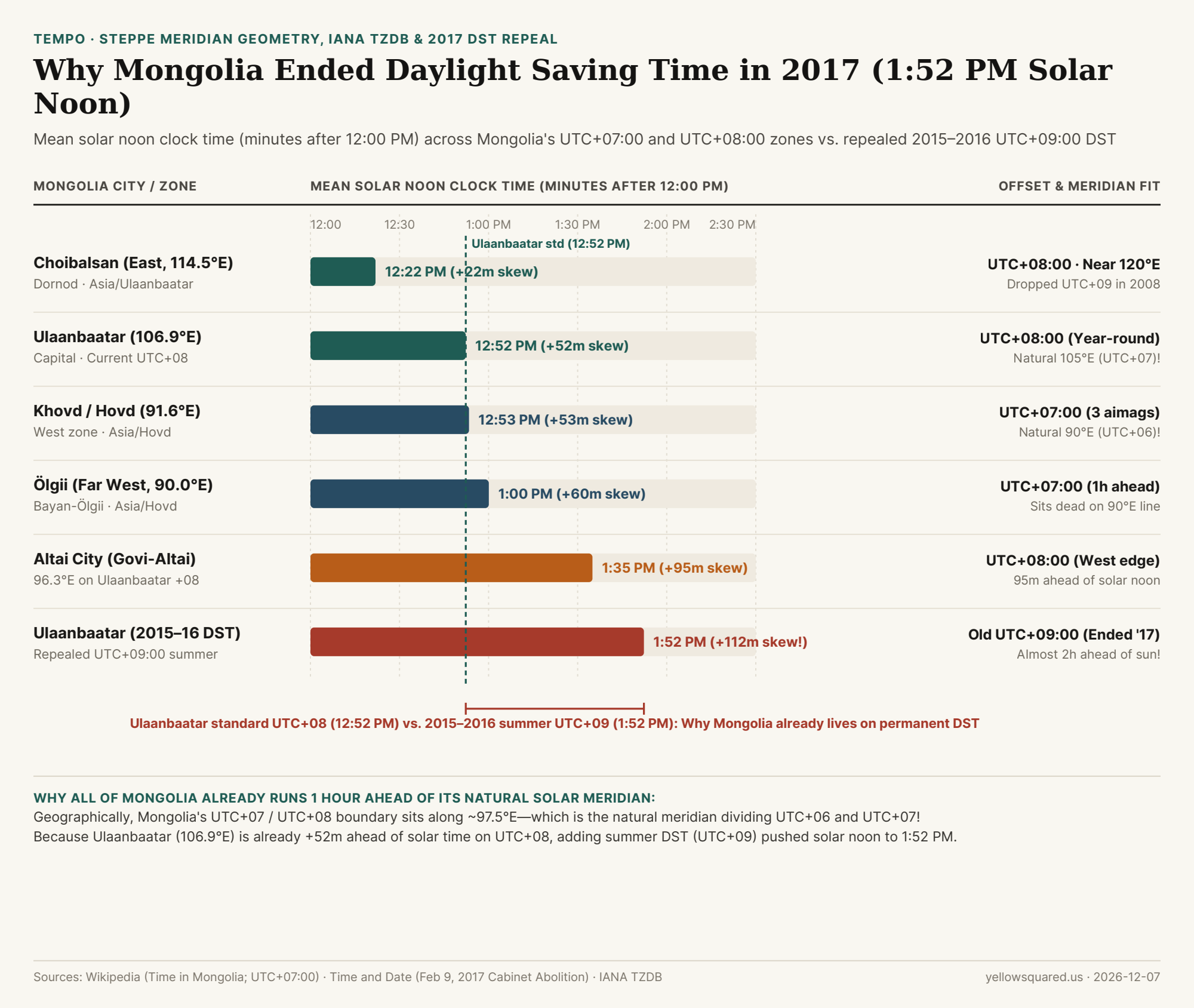
Stretching 2,392 kilometers from the snow-capped Altai peaks on the Kazakh-Russian border (87°45'E) to the eastern steppes of Dornod (119°56'E), Mongolia spans more than 32 degrees of longitude. Today, the country divides its 21 provinces (aimags) across two permanent time zones: Hovd Time (HOVT, UTC+07:00) in the three far-western provinces of Bayan-Ölgii, Uvs, and Khovd, and Ulaanbaatar Time (ULAT, UTC+08:00) across the remaining 18 provinces—including the capital Ulaanbaatar and eastern Choibalsan. Yet as documented in Mongolian civil timekeeping records and geographical analyses of the UTC+07:00 meridian band, Mongolia's entire time-zone map is shifted exactly one hour east of its physical sun—the core reason its 2015–2016 return to Daylight Saving Time collapsed in February 2017.
Figure 1: Mean solar noon clock time (minutes after 12:00 PM) across Mongolia's UTC+07:00 and UTC+08:00 zones compared against the repealed 2015–2016 UTC+09:00 Daylight Saving Time regime. Data: Time in Mongolia (Wikipedia) and UTC+07:00 Meridian Survey (download CSV).
The 97.5°E Meridian Anomaly: Why All of Mongolia Lives on De Facto Permanent DST
In standard spherical astronomy, every 1-hour time zone is 15° wide: the UTC+06:00 zone is centered on 90°E (82.5°E to 97.5°E), the UTC+07:00 zone is centered on 105°E (97.5°E to 112.5°E), and the UTC+08:00 zone is centered on 120°E (112.5°E to 127.5°E). Compare those physical meridians against Mongolia's official zone boundary:
The 97.5°E Boundary Shift: Mongolia draws the border between its western UTC+07:00 zone (Asia/Hovd) and its central/eastern UTC+08:00 zone (Asia/Ulaanbaatar) almost dead along the 97.5°E meridian—which is actually the geometric dividing line between UTC+06:00 and UTC+07:00!
Ulaanbaatar (106°55'E = 106.92°E): Located less than two degrees east of the 105°E meridian, Mongolia's capital belongs geographically in UTC+07:00 (where mean solar noon would fall at 11:52 AM). Because Ulaanbaatar observes UTC+08:00 (matching Beijing, Hong Kong, and Singapore), its mean solar noon sits 52.3 minutes late at 12:52 PM year-round.
Khovd (91.64°E) and Ölgii (89.97°E): In the far-western Altai aimags, Ölgii sits at 89°58'E—within two arcminutes of the exact 90°00'E center of UTC+06:00. By observing UTC+07:00, Ölgii and Khovd also run 53 to 60 minutes ahead of solar noon (12:53 PM and 1:00 PM).
What Happened to Mongolia's Third Time Zone (Asia/Choibalsan)? Until March 2008, eastern Dornod and Sükhbaatar provinces observed a third Mongolian time zone at UTC+09:00. Because Choibalsan (114.53°E) actually sits inside the natural 120°E (UTC+08:00) band, shifting Choibalsan back to UTC+08:00 in 2008 gave eastern Mongolia the truest solar clock in the country (mean solar noon at 12:22 PM).
"Because Mongolia's internal time-zone border along 97.5°E is shifted one full zone east of its physical meridians, both Khovd (UTC+07:00) and Ulaanbaatar (UTC+08:00) already operate on permanent year-round Daylight Saving Time."
Why Mongolia Tried—and Repealed—Summer Daylight Saving Time Three Separate Times (1998, 2006, and 2017)
Because Ulaanbaatar (UTC+08:00) already sits 52 minutes ahead of its natural solar clock (and western cities in the Ulaanbaatar zone like Altai City at 96.26°E sit 95 minutes ahead, with winter solar noon at 1:35 PM), layering an additional hour of summer Daylight Saving Time (ULAST, UTC+09:00 in Ulaanbaatar and HOVST, UTC+08:00 in Khovd) created an extreme "double summer time" skew:
Three On-Again, Off-Again Trials: Mongolia introduced Soviet-style DST from 1983 to 1998 (repealed in 1999), reinstated it from 2001 to 2006 (repealed in February 2007), and briefly revived it a third time in March 2015 and March 2016.
The 1:52 PM Solar Noon and February 9, 2017 Repeal: During the summers of 2015 and 2016 on UTC+09:00, mean solar noon in Ulaanbaatar was pushed to 1:52 PM (and to 2:35 PM in Altai City), keeping the sun above the horizon past 9:50 PM in June while forcing residents to wake two hours before solar dawn in spring and autumn. On February 9, 2017, the Mongolian Cabinet permanently abolished Daylight Saving Time, locking the country onto year-round UTC+07:00 (west) and UTC+08:00 (center/east).
Mongolia City / Regime
IANA TZDB Zone
Longitude
Official Offset
Natural Solar Zone
Mean Solar Noon
Solar Skew & Policy Status
Choibalsan (East)
Asia/Ulaanbaatar
114.53°E
UTC+08:00
UTC+08:00 (120°E)
12:22 PM
+21.9 min · Merged into +08 in 2008
Ulaanbaatar (Capital)
Asia/Ulaanbaatar
106.92°E
UTC+08:00
UTC+07:00 (105°E)
12:52 PM
+52.3 min · Year-round since Feb 2017
Khovd / Hovd (West)
Asia/Hovd
91.64°E
UTC+07:00
UTC+06:00 (90°E)
12:53 PM
+53.4 min · 1 hr behind Ulaanbaatar
Ölgii (Far West)
Asia/Hovd
89.97°E
UTC+07:00
UTC+06:00 (90°E)
1:00 PM
+60.1 min · Dead on 90°E meridian
Altai City (Govi-Altai)
Asia/Ulaanbaatar
96.26°E
UTC+08:00
UTC+06:00 (90°E)
1:35 PM
+95.0 min · West edge of ULAT zone
Ulaanbaatar (2015–16 DST)
Repealed (ULAST)
106.92°E
UTC+09:00
UTC+07:00 (105°E)
1:52 PM
+112.3 min · Abolished Feb 9, 2017
How to Coordinate Schedules Between Ulaanbaatar, Western Mongolia, and Global Hubs
Because Ulaanbaatar stays on permanent UTC+08:00 without DST, it matches the clock of Beijing, Taipei, Singapore, and Perth 365 days a year, while western Mongolia (Asia/Hovd on UTC+07:00) matches Bangkok, Hanoi, Jakarta, and Krasnoyarsk. Open Tempo in your browser to compare live working hours between Ulaanbaatar, Khovd, Europe, and North America.
008 / 56
Why Does Portugal Use London Time (UTC+00:00) After Abandoning Central European Time in 1996?
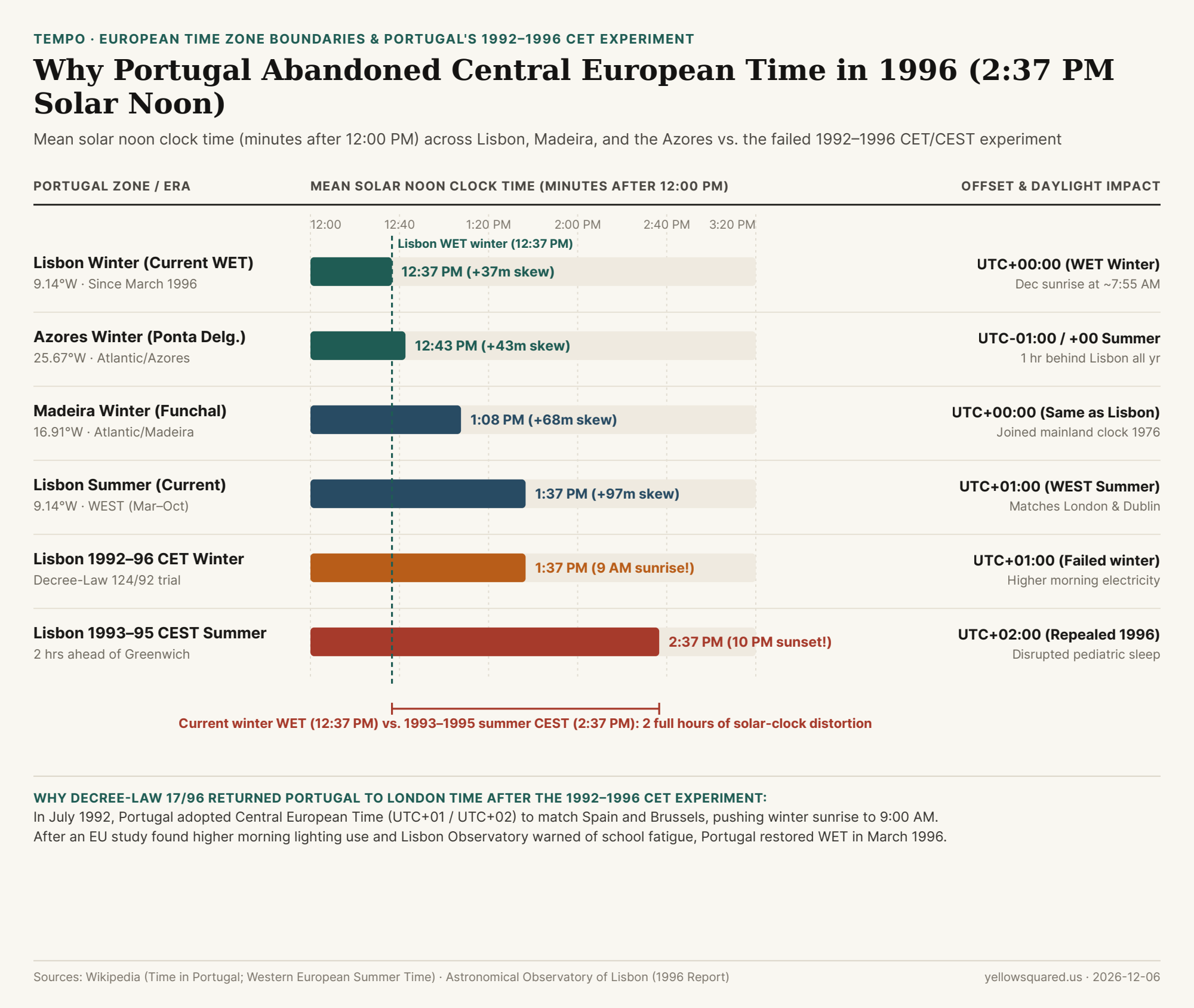
Drive east across the Guadiana River bridge from the Algarve in southern Portugal into Andalusia in Spain—or cross the northern border from Valença into Tui, Galicia—and your phone clock jumps forward by one full hour, even though Spain's western provinces sit at the exact same longitude as Portugal. Today, continental Portugal and Madeira observe Western European Time (WET, UTC+00:00) in winter and Western European Summer Time (WEST, UTC+01:00) from the last Sunday in March to the last Sunday in October, matching London, Dublin, and Reykjavik while sitting 1 hour behind Madrid (CET/CEST), Paris, and Berlin. Yet as documented in Portuguese legislative and astronomical timekeeping archives and European summer time records, Portugal actually tried switching to Central European Time twice in the twentieth century (from 1966 to 1976 and again from 1992 to 1996)—and both experiments collapsed under the weight of solar geometry.
Figure 1: Mean solar noon clock time (minutes after 12:00 PM) across continental Portugal, Madeira, and the Azores compared against the repealed 1992–1996 Central European Time experiment. Data: Time in Portugal (Wikipedia) and Western European Summer Time (download CSV).
Why Continental Portugal Sits West of the 7°30'W Boundary (Inside the Natural UTC-01:00 Zone!)
To understand why Central European Time (UTC+01:00 in winter, UTC+02:00 in summer) wreaked havoc on daily life in Lisbon and Porto, start with the globe's 15° solar meridians (Summer time in Europe):
The 7°30'W Solar Boundary: The Prime Meridian zone (UTC+00:00, centered on 0° at Greenwich) extends mathematically from 7°30'E to 7°30'W (7.50°W). West of 7.50°W lies the natural UTC-01:00 solar zone (centered on 15°W).
Where Lisbon and Porto Actually Sit: Virtually all of continental Portugal lies west of 7°30'W! Porto sits at 8°37'W (8.62°W) and Lisbon sits at 9°08'W (9.14°W). Because every degree west delays solar noon by 4 minutes, the sun crosses Lisbon's meridian 36.6 minutes after Greenwich Mean Time. Even on Greenwich time (UTC+00:00), Lisbon's mean solar noon already falls late at 12:37 PM in winter (and 1:37 PM in summer on UTC+01:00).
Madeira (16.91°W) and the Azores (25.67°W): Located out in the Atlantic, Funchal, Madeira (Atlantic/Madeira) sits 68 minutes west of Greenwich (mean winter solar noon at 1:08 PM on UTC+00:00), while Ponta Delgada in the Azores (Atlantic/Azores, 25°40'W) sits 103 minutes west of Greenwich and observes UTC-01:00 in winter (UTC+00:00 in summer)—keeping the Azores 1 hour behind Lisbon year-round.
"When Decree-Law 124/92 put Lisbon (9.14°W) on Central European Summer Time (UTC+02:00), mean solar noon was pushed to 2:37 PM—leaving the sun in the sky until 10:15 PM in June and delaying December sunrise past 9:00 AM."
What Went Wrong During Portugal's 1992–1996 Central European Time Experiment
In July 1992, via Decree-Law 124/92, Prime Minister Aníbal Cavaco Silva's government shifted mainland Portugal from WET (UTC+00:00) to CET (UTC+01:00) in winter and CEST (UTC+02:00) in summer so Portuguese banks, ministries, and stock markets would share the exact same working hours as Spain and the European Economic Community in Brussels. Within a single cycle of winter and summer, public backlash mounted across four fronts documented in the 1996 Parliamentary and Lisbon Observatory review:
Pitch-Black 9:00 AM Winter School Commutes: In December and January under UTC+01:00, sunrise in Lisbon and Porto did not occur until 9:00 AM. Students arrived for first-period classes under streetlamps, and police and insurers recorded a measurable spike in morning traffic accidents and assaults on children walking to school in the dark.
10:00 PM Summer Daylight and Pediatric Sleep Deprivation: During the summers of 1993, 1994, and 1995 under CEST (UTC+02:00)—nearly 2 hours and 37 minutes ahead of Lisbon's solar meridian—sunset arrived after 9:30 PM and civil twilight lingered until 10:00 PM to 10:30 PM, disrupting children's circadian sleep onset.
Higher Electricity Consumption (The Forgotten Office-Light Paradox): A study commissioned by the European Commission found that the 1992 shift failed to save energy: because winter mornings were pitch-black at 8:30 AM, office workers switched on all overhead fluorescent lights upon arrival and forgot to turn them off once the sun finally rose after 9:00 AM.
Worse Summer Smog From Rush-Hour Alignment: Shifting afternoon rush hour (5:00 PM–7:00 PM clock time) one hour earlier in true solar time aligned peak vehicle exhaust emissions with the hottest, highest-UV afternoon hours (2:30 PM–4:30 PM solar time), worsening ground-level ozone pollution.
In December 1995, newly elected Prime Minister António Guterres commissioned an urgent scientific audit from the Astronomical Observatory of Lisbon (Observatório Astronómico de Lisboa). Following the Observatory's February 1996 recommendation, Parliament unanimously passed Decree-Law 17/96, returning continental Portugal to WET (UTC+00:00) / WEST (UTC+01:00) on March 31, 1996.
Portuguese Zone or Historical Era
IANA TZDB Zone
Longitude
Winter Offset
Summer Offset
Mean Solar Noon
Daylight & Policy Outcome
Lisbon Winter (Current WET)
Europe/Lisbon
9.14°W
UTC+00:00
UTC+01:00
12:37 PM
Restored by Decree-Law 17/96; Dec sunrise ~7:55 AM
Ponta Delgada (Azores)
Atlantic/Azores
25.67°W
UTC-01:00
UTC+00:00
12:43 PM
1 hr behind Lisbon all year; matches EU DST dates
Funchal (Madeira)
Atlantic/Madeira
16.91°W
UTC+00:00
UTC+01:00
1:08 PM
Aligned with mainland Lisbon clock since 1976
Lisbon Summer (Current WEST)
Europe/Lisbon
9.14°W
UTC+00:00
UTC+01:00
1:37 PM
June sunset ~9:05 PM; matches London & Dublin
Lisbon 1992–1996 CET Winter
Repealed (124/92)
9.14°W
UTC+01:00
UTC+02:00
1:37 PM
9:00 AM winter sunrises; higher morning electricity
Lisbon 1993–1995 CEST Summer
Repealed (124/92)
9.14°W
UTC+01:00
UTC+02:00
2:37 PM
10:00 PM twilight; pediatric sleep disruption
How to Track Lisbon, Azores, and Madrid Time Overlaps Year-Round
Because Portugal, Spain, the UK, and the Azores all switch their clocks on the exact same European Union timestamps (01:00 UTC on the last Sunday of March and the last Sunday of October), the offsets between them stay constant all year: Lisbon and Madeira always match London (0h difference), sit 1 hour behind Madrid and Paris, and sit 1 hour ahead of the Azores. Open Tempo in your browser to plan cross-border rail trips and remote calls across Lisbon, Ponta Delgada, Madrid, and North America.