YellowSquared  /  Field notes

Notes from the workshop

56 posts, newest first. Choose an app to narrow the feed.

025 / 56

Why Is Nepal on a 45-Minute Time Zone (UTC+05:45)—And 15 Minutes Ahead of India?

If you cross the land border from Raxaul, India, into Birgunj, Nepal—or book a short 90-minute flight from New Delhi (DEL) to Kathmandu (KTM)—your phone clock performs one of the strangest jumps in global aviation: it advances by exactly 15 minutes. While all of India and Sri Lanka observe Indian Standard Time (UTC+05:30) and neighboring Bangladesh and Bhutan sit on UTC+06:00, Nepal operates year-round on Nepal Standard Time (NPT, UTC+05:45). As documented in the UTC+05:45 and Chatham Standard Time Zone historical records and verified by Time and Date's Nepal time zone registry, Nepal is the only sovereign country on Earth whose national clock is set to a 45-minute offset from Coordinated Universal Time.

Why did Nepal abandon the half-hour Indian time zone it had shared for 65 years, how does a sacred 7,134-meter Himalayan peak 100 kilometers east of Kathmandu make UTC+05:45 mathematically more accurate than UTC+05:30, and what happens to timekeeping on the summit ridge of Mount Everest? Here is the complete geographic, astronomical, and software engineering story behind Asia/Kathmandu.

1. Three Eras of Time in Kathmandu: From UTC+05:41:16 to UTC+05:30 to UTC+05:45

To understand why Nepal uses a quarter-hour offset, it helps to trace the three distinct timekeeping regimes recorded in the history of Nepal Standard Time:

  • Pre-1920 Local Mean Solar Time (UTC+05:41:16): Until 1920, Kathmandu did not use an international time zone offset at all. Clocks in the capital were calibrated directly to Kathmandu's local mean solar time at longitude 85°19'E (85.32°E). Because Earth rotates 360° every 24 hours—or 1° of longitude every 4 minutes (4 seconds per arcminute)—Kathmandu's true solar meridian sits exactly 5 hours, 41 minutes, and 16 seconds ahead of the Greenwich Prime Meridian (0°).
  • 1920 to 1985 — The Indian Standard Time Era (UTC+05:30): In 1920, to simplify telegraph, railway, and commercial coordination with British India, Nepal formally adopted Indian Standard Time (UTC+05:30), which is anchored to the 82°30'E meridian passing near Mirzapur in Uttar Pradesh. Because 82°30'E lies nearly three degrees west of Kathmandu and up to six degrees west of eastern Nepal, operating on UTC+05:30 meant Kathmandu's civil clocks lagged 11 minutes and 16 seconds behind local solar time, bringing earlier winter dusks across the Kathmandu Valley and eastern Himalayan trekking corridors.
  • January 1, 1986 — The 15-Minute Sovereign Leap (UTC+05:45): On January 1, 1986, under the reign of King Birendra Bir Bikram Shah Dev, the Government of Nepal officially advanced national clocks by 15 minutes from UTC+05:30 to UTC+05:45. As noted in Himalayan Dream Team's analysis of Nepal's time standard, the shift served a dual purpose: it asserted Nepal's sovereign national identity distinct from its much larger southern neighbor while anchoring civil time to a sacred meridian inside Nepalese territory.
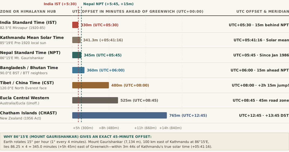
Chart comparing Nepal Standard Time UTC+05:45 (345 minutes ahead of UTC) against India IST UTC+05:30, Kathmandu solar mean time UTC+05:41:16, Bangladesh/Bhutan UTC+06:00, China UTC+08:00, Eucla UTC+08:45, and Chatham Islands UTC+12:45
Figure 1: Total offset in minutes ahead of UTC across South Asian meridians and the world's only three 45-minute time zones (Wikipedia — Nepal Standard Time; Chatham Standard Time Zone).

2. The Longitude Math of Mount Gaurishankar (86°15'E)

Why did Nepal choose +05:45 rather than jumping a full 30 minutes to UTC+06:00 like Bangladesh and Bhutan? The answer is pure spherical astronomy. Standard 1-hour time zones are spaced every 15° of longitude (60 minutes), half-hour time zones sit at 7.5° increments (30 minutes), and quarter-hour time zones sit at 3.75° (3°45') increments (15 minutes).

To produce an exact +5 hour 45 minute (345-minute) solar offset from Greenwich, a reference meridian must lie at:

  • Exact Target Meridian: 345 minutes ÷ 4 minutes per degree = 86.25°E, which in degrees and arcminutes is 86°15'E (86°15'–86°20'E).
  • The Sacred Peak Anchor: Approximately 100 kilometers (62 miles) east-northeast of Kathmandu in the Rolwaling Himal stands Mount Gaurishankar (7,134 meters / 23,406 feet), the second-highest peak of the Rolwaling range, revered in both Hindu and Buddhist traditions (named after the goddess Gauri and her consort Shankar/Shiva). As documented by Wikipedia's Nepal Standard Time entry, Nepal designated the meridian passing through the summit of Mount Gaurishankar as its national standard meridian.
  • 3 Minutes 44 Seconds from Perfect Solar Time: Because Kathmandu's local mean solar time is UTC+05:41:16, anchoring Nepal Standard Time to UTC+05:45:00 places the capital's clocks within just 3 minutes and 44 seconds of true solar noon—roughly three times closer to solar reality than the 11 minute 16 second error under Indian Standard Time (UTC+05:30) and five times closer than the 18 minute 44 second error that UTC+06:00 would have imposed.

"NPT is an approximation of Kathmandu mean time, which is 5 hours, 41 minutes, and 16 seconds ahead of UTC. The standard meridian passes through the peak of Gaurishankar mountain about 100 kilometres (62 mi) east of Kathmandu."

3. The World's Only Three 45-Minute Time Zones

According to the UTC+05:45 and Chatham Standard Time Zone registries, out of more than 400 regional zones in the IANA tz database, only three regions on Earth operate on a :45 minute offset—and only two have official statutory status:

  1. Nepal Standard Time (NPT, UTC+05:45 — Asia/Kathmandu): The only national, country-wide 45-minute time zone on Earth, covering ~30 million residents across all of Nepal since January 1, 1986. As confirmed by Time and Date, Nepal has never observed Daylight Saving Time (DST), so UTC+05:45 holds 365 days a year.
  2. Chatham Standard Time Zone (CHAST, UTC+12:45 / CHADT, UTC+13:45 — Pacific/Chatham): Used exclusively on New Zealand's Chatham Islands (~800 km east of New Zealand's South Island, population ~800). As documented in Wikipedia's Chatham Standard Time Zone article, the islands have kept time 45 minutes ahead of mainland New Zealand since at least the late 1920s, codified into law by New Zealand's Standard Time Amendment Act 1956. Unlike Nepal, the Chatham Islands observe Daylight Saving Time from the last Sunday in September (02:45) to the first Sunday in April (03:45), shifting to UTC+13:45.
  3. Australian Central Western Time (ACWST, UTC+08:45 — Australia/Eucla): An unofficial but universally observed highway time zone used by fewer than 200 residents at roadhouses along the Eyre Highway in Western Australia (Border Village, Eucla, Madura, Mundrabilla, and Cocklebiddy) between Caiguna and the South Australian border, splitting the 90-minute gap between Western Australia (UTC+08:00) and South Australia (UTC+09:30).

4. Complete Data Table: Himalayan Neighbor Offsets & Global 45-Minute Zones

The dataset below—bundled in the downloadable CSV (nepal-standard-time-utc-05-45-gaurishankar-meridian-and-global-45-minute-zones.csv)—compares Nepal's historical and modern time standards against its immediate South and East Asian neighbors and the two other 45-minute zones worldwide:

Time Zone or Historical Era IANA Identifier Reference Meridian Solar Offset vs. UTC Official Civil Offset Total Offset (Min) Gap vs. Nepal (UTC+05:45)
Indian Standard Time (IST — Nepal 1920–1985) Asia/Kolkata 82°30'E (Mirzapur) +5h 30m 00s UTC+05:30 (No DST) 330.0 min 15 min behind Nepal
Kathmandu Local Mean Solar Time (Pre-1920) Local Solar Time 85°19'E (Kathmandu) +5h 41m 16s UTC+05:41:16 341.27 min 3 min 44 sec behind modern NPT
Nepal Standard Time (NPT — Since Jan 1, 1986) Asia/Kathmandu 86°15'E (Mt. Gaurishankar) +5h 45m 00s UTC+05:45 (No DST) 345.0 min Baseline (0 min)
Bangladesh & Bhutan Time (BST / BTT) Asia/Dhaka · Asia/Thimphu 90°00'E +6h 00m 00s UTC+06:00 (No DST) 360.0 min 15 min ahead of Nepal
Myanmar Standard Time (MMT) Asia/Yangon 97°30'E +6h 30m 00s UTC+06:30 (No DST) 390.0 min 45 min ahead of Nepal
China Standard Time (Tibet / Everest North Face) Asia/Shanghai 120°00'E (Beijing) +8h 00m 00s UTC+08:00 (No DST) 480.0 min 2 hr 15 min ahead across summit
Australian Central Western Time (Eucla) Australia/Eucla 131°15'E +8h 45m 00s UTC+08:45 (Unofficial) 525.0 min 3 hr 00 min ahead of Nepal
Chatham Standard Time Zone (New Zealand) Pacific/Chatham 176°15'W equiv. +12h 45m 00s UTC+12:45 (+13:45 DST) 765.0 min 7 hr 00 min ahead (8 hr in DST)

5. The Mount Everest Paradox and Software Engineering Pitfalls

Nepal's UTC+05:45 offset creates two famous real-world edge cases for mountaineers and software developers:

  • The 2-Hour 15-Minute Jump on the Summit of Mount Everest: Mount Everest (Sagarmatha / Chomolungma, 8,848.86 m) straddles the international border between Nepal on its southern flank and the Tibet Autonomous Region of China on its northern flank. Because all of China uses a single nationwide time zone anchored to Beijing at 120°E (UTC+08:00), stepping across the summit ridge from the Nepalese South Col route (UTC+05:45) onto the Tibetan Northeast Ridge route legally advances the clock by 2 hours and 15 minutes in a single stride.
  • Why Integer-Hour and Half-Hour Cron Parsers Break on Asia/Kathmandu: In backend engineering, QA teams routinely use Asia/Kathmandu (+05:45) alongside Asia/Kolkata (+05:30) and Pacific/Chatham (+12:45) as unit-test fixtures. Any naive time-zone picker or cron scheduler that stores UTC offsets as an integer number of hours—or even as 0.5-hour floats without quarter-hour (0.25-hour / 900-second) precision—will corrupt timestamps or misalign meeting invites for users in Nepal.

When you are coordinating remote standups, flights, or expedition logistics across Kathmandu (UTC+05:45), New Delhi (UTC+05:30), London, and Seattle, Open Tempo in your browser to visualize quarter-hour time-zone offsets side by side without mental arithmetic errors.
026 / 56

Why Does Iceland Never Change Its Clocks? How Reykjavik Ended Up on Permanent UTC+00:00

Look at a globe of the North Atlantic and you will notice that Iceland lies more than 1,500 kilometers northwest of Great Britain, stretching between longitudes 13.5°W and 24.5°W—far to the west of Ireland, Portugal, and Morocco, and directly north of the mid-Atlantic islands that use UTC−01:00 and UTC−02:00. Yet if you check the local time in Reykjavík (21.94°W) or land at Keflavík International Airport (22.61°W), Iceland is set to Greenwich Mean Time (UTC+00:00) 365 days a year, with zero Daylight Saving Time transitions in March or October.

Because Reykjavík sits nearly 22 degrees west of the 0° Greenwich meridian, locking the nation's clocks to UTC+00:00 means that Iceland is effectively living on permanent Daylight Saving Time—roughly 88 to 98 minutes ahead of local solar time. On the December 21 winter solstice, true solar noon in Reykjavík does not occur until 1:28 PM, and the sun does not clear the horizon until 11:22 AM (and in the Westfjords, after 12:00 PM noon!). Here is why Iceland adopted UTC−01:00 in 1908, why the Icelandic parliament (Althing) permanently locked the country onto UTC+00:00 on April 7, 1968, and why the government rejected a major campaign to move clocks back an hour in 2020.

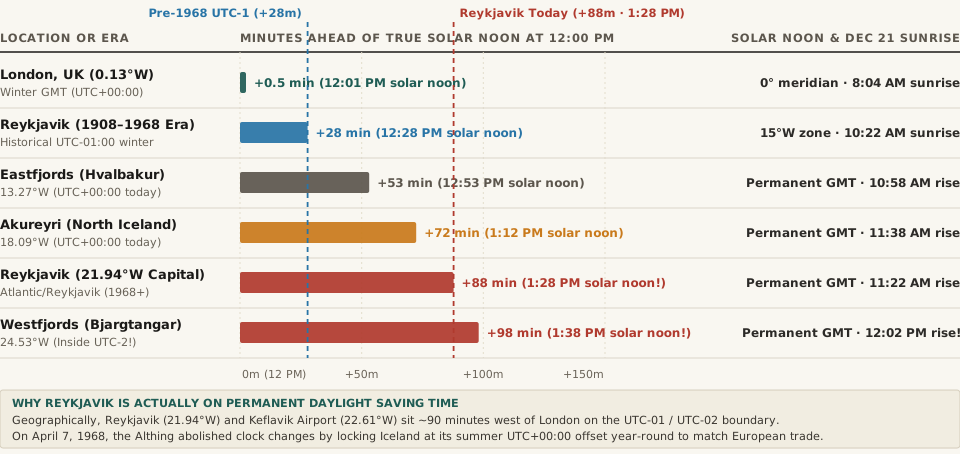
Horizontal bar chart showing the delay in minutes between 12:00 PM clock noon and true solar noon across London, pre-1968 Reykjavik, Eastfjords, Akureyri, modern Reykjavik (+88 minutes at 1:28 PM), and Westfjords (+98 minutes at 1:38 PM)
Figure 1: Minutes between 12:00 PM clock noon and true solar noon across Iceland under its permanent UTC+00:00 time zone (adopted April 7, 1968), compared against London and pre-1968 UTC−01:00 standard time. Download the raw dataset: iceland-permanent-utc-00-since-1968-reykjavik-solar-noon-and-solstice-hours.csv.

1. From Local Solar Time to the 1907 Telephone Act (UTC−01:00)

For the first thousand years of Icelandic settlement, an island with no cross-border railways and scattered coastal towns had no need for a unified national time zone; each town set its clocks to local mean solar time (in Reykjavík at 21°56'W, local solar noon trailed Greenwich by 1 hour and 28 minutes). That changed in 1906 with the founding of Iceland's national telephone and telegraph company, Landssíminn, which connected Reykjavík to the Eastfjords and Europe via submarine cable.

As documented in the parliamentary history of Time in Iceland, the Althing passed a law on November 16, 1907 (taking effect in 1908) establishing UTC−01:00 (anchored to the 15°W meridian passing through eastern Iceland) as Iceland's official national standard time. First during World War I (1917–1921) and then continuously for 29 years from 1939 to 1968, Iceland observed seasonal Daylight Saving Time—advancing its clocks by one hour from UTC−01:00 to UTC+00:00 in spring (first Sunday in March or April) and turning them back to UTC−01:00 in late October.

2. Why the Althing Abolished Clock Shifts on April 7, 1968

By the late 1960s, the twice-yearly clock shift had become deeply unpopular across Iceland. Because Iceland lies just south of the Arctic Circle (64°N to 66.5°N), natural daylight swings from nearly 21–24 hours of continuous light in June to just 4 hours of low twilight in December. Moving a clock hand by one hour in spring and autumn did nothing to change the sub-Arctic sun cycle, yet—as summarized in the 1968 legislative record on Wikipedia—it created three constant headaches:

  • Transatlantic Aviation Timetable Chaos: As Keflavík and Reykjavík became key North Atlantic stopover hubs between North America and Europe (through Loftleiðir / Icelandair), mismatched DST transition dates between Iceland, the UK, Continental Europe, and the U.S. scrambled flight schedules twice a year.
  • Infant and Household Sleep Disruption: Parents and physicians complained that resetting clocks every April and October disrupted sleep rhythms across households without adding useful summer evening light (since June nights were already bright at midnight!).
  • European Telephone & Trade Alignment: Iceland's business leaders wanted to keep the UTC+00:00 summer offset year-round so Reykjavík's workday remained synchronized with London and just one hour behind Copenhagen, Oslo, and Frankfurt during the winter trading season.

On April 5, 1968, the Althing voted to abolish seasonal clock shifts and lock Iceland permanently on UTC+00:00 (Greenwich Mean Time) starting on Sunday, April 7, 1968—a zone it has kept without a single clock change for nearly six decades.

“On April 7, 1968, Iceland advanced its clocks from UTC−01:00 to UTC+00:00 for the spring transition and simply never turned them back—locking Reykjavík 88 minutes ahead of true solar time year-round.”

3. The 1:28 PM Solar Noon Skew and the 2018–2020 Health Debate

What does living on permanent UTC+00:00 do to sunrise, solar noon, and sunset across Iceland's 11-degree longitudinal span? Compare the numbers across regions:

Icelandic Location or Era Longitude Natural Solar Zone Official Civil Zone Solar Noon Delay After 12 PM True Solar Noon Clock Time Dec 21 Winter Solstice Sunrise & Sunset
London, UK (Reference) 0.13°W UTC+00:00 (0°) UTC+00 (UTC+01 BST) +0.5 min (Winter) 12:01 PM 8:04 AM sunrise · 3:53 PM sunset
Reykjavík Pre-1968 (1908–1968) 21.94°W UTC−01:00 (15°W) UTC−01:00 Standard +27.8 min 12:28 PM 10:22 AM sunrise · 2:29 PM sunset
Eastfjords (Hvalbakur / Seyðisfjörður) 13.27°W UTC−01:00 (15°W) UTC+00:00 (Since 1968) +53.1 min 12:53 PM 10:58 AM sunrise · 2:43 PM sunset
Akureyri (North Iceland) 18.09°W UTC−01:00 (15°W) UTC+00:00 (Since 1968) +72.4 min 1:12 PM 11:38 AM sunrise · 2:45 PM sunset
Reykjavík (Capital — Since 1968) 21.94°W UTC−01 / UTC−02 UTC+00:00 Year-Round +87.8 min 1:28 PM! 11:22 AM sunrise · 3:29 PM sunset
Keflavík International Airport (KEF) 22.61°W UTC−02:00 (30°W) UTC+00:00 Year-Round +90.4 min 1:30 PM! 11:24 AM sunrise · 3:33 PM sunset
Westfjords (Ísafjörður / Bjargtangar) 24.53°W UTC−02:00 (30°W) UTC+00:00 Year-Round +98.1 min 1:38 PM! 12:02 PM sunrise! · 2:57 PM sunset

Notice a remarkable geographic fact: because the boundary between the geographical UTC−01:00 zone (7.5°W–22.5°W) and the geographical UTC−02:00 zone (22.5°W–37.5°W) runs right along the 22.5°W meridian through the Reykjanes Peninsula, Keflavík International Airport (22.61°W) and the Westfjords (24.53°W) actually sit inside the natural UTC−02:00 zone—two full hours west of their official UTC+00:00 clock!

In January 2018, a working group under Iceland's Ministry of Health (including sleep physiologist Björg Þorleifsdóttir) concluded that keeping Reykjavík 88 minutes ahead of solar time caused measurable social jet lag in teenagers during dark winter mornings (when students sit in school for three hours before the 11:22 AM sunrise), recommending a return to UTC−01:00. However, in September 2020, Prime Minister Katrín Jakobsdóttir's cabinet officially decided to keep UTC+00:00 after calculating that shifting clocks back an hour would reduce usable afternoon daylight during waking hours by 13% across spring, autumn, and winter.

Track Iceland, UK, and U.S. Seasonal Time Shifts in Tempo

Because Iceland stays on UTC+00:00 year-round (Atlantic/Reykjavik) while London switches between UTC+00:00 and UTC+01:00 (BST) and the United States shifts between March and November, the time gap between U.S. cities and Reykjavík changes twice a year even though Iceland never touches its clocks. Open Tempo in your browser to check exact flight and call overlaps with Reykjavík for any date of the year.

027 / 56

Why Does Spain Use Central European Time (UTC+1) Instead of London Time (GMT)?

Trace your finger straight down the map of Western Europe from London (0.13°W) and you will pass well to the east of Madrid (3.70°W), Seville (5.98°W), and Vigo (8.72°W). In fact, the 0° Greenwich Prime Meridian slices right through eastern Spain near Zaragoza and Castellón de la Plana, placing more than 85% of Spain's landmass in the Western Hemisphere. Yet when you fly due south from London to Madrid—or drive 15 minutes east across the river border from Valença, Portugal into Tui, Spain—you have to set your watch forward by one full hour to Central European Time (UTC+01:00 in winter, UTC+02:00 in summer), putting western Spain on the exact same clock as Warsaw, Berlin, and Belgrade more than 2,500 kilometers to the east.

Why does Spain operate in the wrong geographical time zone—and how does that 60-to-155-minute gap between clock time and solar time explain why Spaniards famously eat lunch at 2:00 PM and dinner at 9:30 to 10:00 PM? Here is the complete historical and astronomical breakdown of Time in Spain.

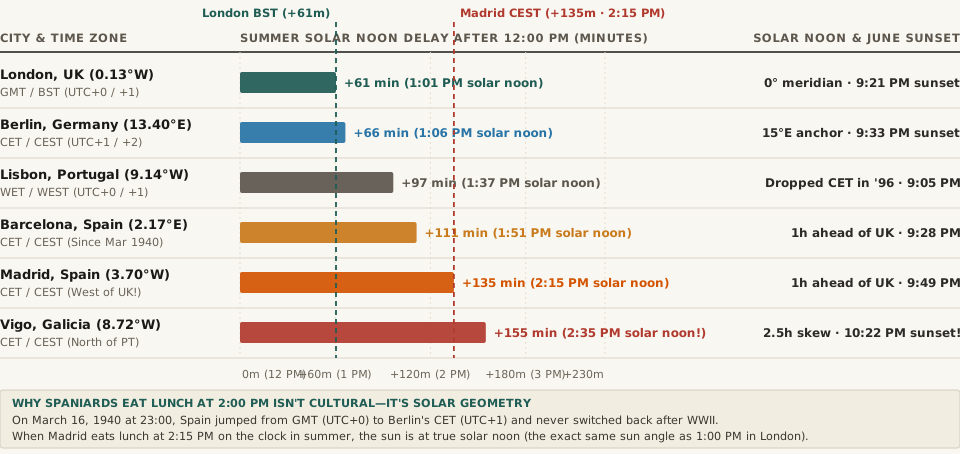
Horizontal bar chart comparing summer solar noon delay in minutes after 12:00 PM across London, Berlin, Lisbon, Barcelona, Madrid, and Vigo, showing Vigo's 155-minute solar skew at 2:35 PM
Figure 1: Delay in minutes between 12:00 PM clock noon and true solar noon during European summer time (CEST / BST / WEST), showing how Spain's 1940 shift to Central European Time pushes solar noon to 2:15 PM in Madrid and 2:35 PM in Vigo. Download the full dataset: spain-central-european-time-1940-shift-galicia-solar-noon-and-canary-islands.csv.

1. From 1901 GMT Standardization to the Night of March 16, 1940

Until the end of the 19th century, Spanish provinces set their clocks to local mean solar time (with Madrid anchored to the Royal Observatory at 3°41'W, running 14 minutes and 45 seconds behind Greenwich). On July 22, 1900, Prime Minister Francisco Silvela signed a Royal Decree (taking effect on January 1, 1901) that placed all of Peninsular Spain and the Balearic Islands on Greenwich Mean Time (UTC±00:00)—the exact natural 15-degree longitudinal band spanning from 7.5°W to 7.5°E. (When officials realized in 1922 that the 1900 decree hadn't explicitly mentioned the Canary Islands near 15.5°W, the archipelago was assigned to UTC−01:00, matching its natural Atlantic meridian.)

For 39 years, Spain, Portugal, Great Britain, France, and Belgium all shared the Greenwich Mean Time zone. Then came World War II. During the spring of 1940, Nazi Germany occupied France, Belgium, the Netherlands, and Luxembourg, forcing those countries onto Berlin's Mitteleuropäische Zeit (Central European Time, UTC+01:00), while Britain itself adopted wartime British Double Summer Time.

As documented in the official Boletín Oficial del Estado (BOE) order cited in Wikipedia's history of time in Spain, the nationalist government of General Francisco Franco published a ministerial decree on March 7, 1940 stating that on Saturday, March 16, 1940 at 23:00 (11:00 PM GMT), clocks across Spain would jump ahead by 60 minutes to 00:00 (midnight CET) on March 17, “in consideration of the convenience of the national horario marching in step with that of other European countries.” Simultaneously, the Canary Islands were shifted 60 minutes forward from UTC−01:00 to UTC+00:00.

Although the March 1940 order explicitly described the advance as a temporary measure until a permanent return to Greenwich time could be decreed, neither Spain nor France ever turned its clocks back after 1945 (whereas the United Kingdom and Portugal returned to GMT).

“At 11:00 PM on March 16, 1940, Spain advanced its clocks by an hour from Greenwich Mean Time to Berlin's Central European Time—and never switched back after World War II.”

2. The Solar Noon Math: Why 2:15 PM in Madrid Is Actually 12:00 Noon by the Sun

Because the Earth rotates 360 degrees in 24 hours—or exactly 15 degrees of longitude per hour (4 minutes of time per degree of longitude)—Central European Time (UTC+01:00) is mathematically anchored to the 15°E meridian (which runs through eastern Germany near Görlitz, Prague, and southern Sweden). During summer Daylight Saving Time (CEST, UTC+02:00, observed from the last Sunday in March to the last Sunday in October), Spanish clocks are anchored to the 30°E meridian—the longitude of Kyiv, Istanbul, and Cairo!

Look at what happens when you apply a 30°E summer clock to cities sitting at 3.7°W to 9.2°W in western Iberia:

European City or Spanish Region Longitude Official Time Zone (Winter / Summer) Winter Solar Noon Delay (Min After 12 PM) Summer Solar Noon Delay (Min After 12 PM) Summer Solar Noon & June Sunset Historical & Statutory Rule
Berlin, Germany (CET Anchor) 13.40°E CET (UTC+1) / CEST (UTC+2) +6.4 min (~12:06 PM) +66.4 min (~1:06 PM) 1:06 PM · ~9:33 PM sunset Natural 15°E meridian anchor for Central European Time
London, UK (Prime Meridian) 0.13°W GMT (UTC+0) / BST (UTC+1) +0.5 min (~12:01 PM) +60.5 min (~1:01 PM) 1:01 PM · ~9:21 PM sunset Natural 0° Prime Meridian; reverted from wartime BDST in 1947
Lisbon, Portugal (Neighbor) 9.14°W WET (UTC+0) / WEST (UTC+1) +36.6 min (~12:37 PM) +96.6 min (~1:37 PM) 1:37 PM · ~9:05 PM sunset Tested CET in 1992–1996; returned to UTC+0 due to 9:00 AM winter dark
Barcelona, Spain (East Coast) 2.17°E CET (UTC+1) / CEST (UTC+2) +51.3 min (~12:51 PM) +111.3 min (~1:51 PM) 1:51 PM · ~9:28 PM sunset Adopted GMT in Jan 1901; shifted +1h to CET on Mar 16, 1940
Madrid, Spain (Capital) 3.70°W CET (UTC+1) / CEST (UTC+2) +74.8 min (~1:15 PM) +134.8 min (~2:15 PM) 2:15 PM · ~9:49 PM sunset Sits 3.57° west of London yet runs 60 minutes ahead year-round
Vigo / A Coruña (Galicia) 8.72°W CET (UTC+1) / CEST (UTC+2) +94.9 min (~1:35 PM) +154.9 min (~2:35 PM!) 2:35 PM · ~10:22 PM sunset! Directly north of Portugal yet 1h ahead; 2.5-hour summer skew
Canary Islands (Tenerife) 15.43°W WET (UTC+0) / WEST (UTC+1) +61.7 min (~1:02 PM) +121.7 min (~2:02 PM) 2:02 PM · ~9:00 PM sunset 1h behind Madrid (Atlantic/Canary); shifted from UTC−1 in 1940

Why Spaniards Eat Lunch at 2:00 PM and Dinner at 10:00 PM

Visitors to Madrid or Seville are often astonished that restaurants barely open for lunch before 1:30 or 2:00 PM and don't fill up for dinner until 9:30 or 10:00 PM. Yet when you subtract Madrid's 75-minute winter solar offset (or 135-minute summer solar offset), the mystery vanishes completely: when a Madrileno sits down to lunch at 2:00 PM on the clock, the sun is in the exact same position in the sky (true solar 12:30–12:45 PM) as when an Italian in Rome or a Briton in London eats lunch at 12:45 PM! Spaniards do not eat late relative to the sun; their wall clocks are simply set 75 to 155 minutes ahead of solar time.

3. The Galicia Problem and Portugal's 1992–1996 CET Experiment

Nowhere is this distortion more extreme than in Galicia (northwestern Spain, including Vigo, Santiago de Compostela, and A Coruña at 8.4°W–9.2°W). In June, the sun does not set in Vigo until 10:22 PM (with civil twilight lasting past 11:00 PM), while in December and January, the sun does not rise until nearly 9:05 AM—forcing commuters and schoolchildren to start their day in pitch darkness. Indeed, when neighboring Portugal briefly switched from GMT to CET between 1992 and 1996 to match Spain and Brussels, Portuguese schools and pediatricians documented such severe winter morning sleep deprivation and afternoon heat spikes (with 100°F peak afternoon temperatures hitting at 5:00 PM clock time) that Lisbon repealed the experiment in March 1996 and returned to UTC+00:00.

Don't forget Spain's built-in domestic time-zone rule: whenever Spanish national radio or television announces a schedule, presenters famously add the phrase “una hora menos en Canarias” (“one hour earlier in the Canaries”) because Tenerife, Gran Canaria, and Lanzarote (Atlantic/Canary) run on UTC+00:00 / UTC+01:00, matching London and Lisbon rather than Madrid.

Compare Iberian, Canary, and Global Workday Overlaps in Tempo

Whether you are coordinating a cross-border sprint between Madrid (Europe/Madrid), Lisbon (Europe/Lisbon), London (Europe/London), and remote engineers in Las Palmas de Gran Canaria (Atlantic/Canary), checking live UTC offsets prevents the classic Iberian one-hour calendar mistake. Open Tempo in your browser to compare mainland Spain, Canary Islands, UK, and U.S. time zones side by side.

028 / 56

Why Did Samoa Skip Friday, December 30, 2011? (And the 24-Hour Gap to American Samoa)

If you board a twin-turboprop plane in Apia, Samoa at 9:00 AM on Monday and fly 70 kilometers (43 miles) across the ocean to Pago Pago, American Samoa, your flight takes just 35 minutes. Yet when your wheels touch the runway in Pago Pago, the local time is 9:35 AM on Sunday—the day before. You can celebrate your birthday or New Year's Eve from midnight to 11:00 AM in Apia, hop a short commuter flight to Pago Pago, and celebrate the exact same calendar date all over again 24 hours later.

How did two islands of the same Samoan archipelago—sharing the same language, culture, and 171°W longitude band—end up separated by a full 24-hour calendar day (showing the exact same hour and minute on the clock, but one day apart)? The answer goes back to one of the boldest civil timekeeping resets in modern history: at the stroke of midnight on Thursday, December 29, 2011, the independent nation of Samoa (along with the New Zealand territory of Tokelau) fast-forwarded its clocks by 24 hours, completely erasing Friday, December 30, 2011 from its calendar.

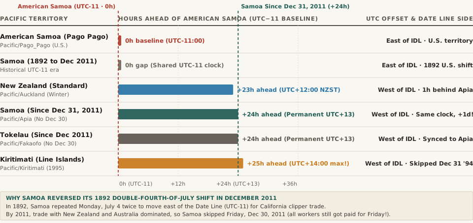
Horizontal comparison chart of Pacific UTC offsets and hours ahead of American Samoa (UTC-11), showing Samoa and Tokelau at +24 hours (UTC+13) after skipping December 30, 2011, and Kiritimati at +25 hours (UTC+14)
Figure 1: Hours ahead of American Samoa (UTC−11:00 baseline) across South Pacific jurisdictions, showing how Samoa's December 2011 shift to UTC+13:00 created a 24-hour calendar gap across 70 km of ocean. Download the raw dataset: samoa-2011-dateline-jump-utc-13-vs-american-samoa-utc-11-and-kiribati-14.csv.

1. Why Samoa Moved East of the Date Line in 1892: The Double Fourth of July

Geographically, the Samoan Islands sit near longitude 171°W to 172°W—about nine degrees east of the 180th meridian. Originally, early European missionaries and traders arriving from Australia and New Zealand kept Asian/Australasian dates in Samoa (west of the International Date Line).

However, in the late 19th century, San Francisco steamship lines and American merchants dominated Samoan maritime trade. To eliminate the one-day calendar mismatch with California, King Malietoa Laupepa was persuaded by U.S. traders in 1892 to move Samoa to the eastern (American) side of the International Date Line. How do you move a country backward by one calendar day? Samoa simply lived through Monday, July 4, 1892 twice in a row—giving American diplomats and traders in Apia two consecutive Fourth of July celebrations and locking Samoa onto UTC−11:00 (Samoa Standard Time) for the next 119 years.

2. The Two-Workday Penalty: Why Samoa Erased Friday, December 30, 2011

By the early 21st century, Samoa's economic gravity had shifted back across the southwest Pacific. Over 70% of Samoa's import/export trade, banking, and expatriate diaspora ties were anchored in New Zealand (UTC+12 / UTC+13 NZDT), Australia (UTC+10 / UTC+11 AEDT), and East Asia. Sitting at UTC−11:00 (23 hours behind Auckland in winter and 24 hours behind in summer) created a crippling four-workday week for Samoan businesses:

  • Monday in Auckland Was Still Sunday in Apia: When New Zealand banks, shipping ports, and government ministries opened on Monday morning, Samoa was still closed for Sunday church and family rest.
  • Friday in Apia Was Already Saturday in Auckland: When Samoan offices worked through Friday, businesses in New Zealand, Sydney, and Tokyo had already closed for the weekend.

To eliminate that two-day weekly dead zone, Samoan Prime Minister Tuilaepa Sailele Malielegaoi pushed through the International Date Line Act 2011. As documented in the historical record for Time in Samoa, at the end of Thursday, December 29, 2011 (23:59:59 UTC−10:00 DST), Samoa jumped straight to 00:00:00 on Saturday, December 31, 2011 (UTC+14:00 DST, UTC+13:00 standard). Friday, December 30, 2011 never happened in Samoa (or in neighboring Tokelau, which jumped on the exact same night so its administrative offices in Apia remained synchronized). Under the statute, employers were legally required to pay salaried and hourly staff a full day's wages for the non-existent Friday, while banks were barred from charging interest for December 30.

“At midnight on Thursday, December 29, 2011, clocks in Apia jumped directly to Saturday, December 31—erasing Friday, December 30 from history so Samoa could share all five weekdays with New Zealand and Australia.”

3. The 24-Hour and 25-Hour Date Line Quirks: Samoa, American Samoa & Kiribati

Because the International Date Line is set by national law rather than international treaty, two major Date Line realignments—Kiribati skipping December 31, 1994 and Samoa skipping December 30, 2011—created the world's most extreme time-zone contrasts. Here is the complete reference table:

Pacific Territory or Time Zone Era IANA Zone Identifier Standard UTC Offset Gap vs. American Samoa (UTC−11) Geographic Longitude Date Line Side & Historical Milestone
American Samoa (Pago Pago) Pacific/Pago_Pago UTC−11:00 0h (Baseline) 170.70°W Stayed east of IDL; last inhabited place on Earth to ring in New Year
Samoa Pre-2011 (1892–Dec 29, 2011) Pacific/Apia (Historical) UTC−11:00 0h (1h in 2010–11 DST) 171.76°W Repeated Monday, July 4, 1892 twice to align with California trade
New Zealand (Auckland / Wellington) Pacific/Auckland UTC+12:00 (UTC+13 DST) +23h Winter / +24h Summer 174.76°E Samoa's top regional trading partner; drove the 2011 Date Line shift
Samoa Post-2011 (Since Dec 31, 2011) Pacific/Apia UTC+13:00 (Year-round) +24h (Same clock, +1 day!) 171.76°W Skipped Dec 30, 2011 to jump to UTC+13; scrapped DST in Sep 2021
Tokelau (NZ Dependent Territory) Pacific/Fakaofo UTC+13:00 (Year-round) +24h Year-Round 171.21°W Skipped Dec 30, 2011 alongside Samoa to match Apia & Wellington
Kiribati Line Islands (Kiritimati) Pacific/Kiritimati UTC+14:00 (Earliest Zone) +25h (+1 day & +1 hour!) 157.47°W Skipped Dec 31, 1994 (UTC−10 to UTC+14) to unify Kiribati's calendar

Why American Samoa Stayed Behind—and Why Samoa Scrapped DST in 2021

When independent Samoa leaped to UTC+13:00 in December 2011, why didn't neighboring American Samoa (just 70 km to the east) jump with it? As an unincorporated territory of the United States whose government, military, and tuna-cannery exports are tied to Honolulu (UTC−10:00) and the U.S. mainland, American Samoa stayed on UTC−11:00. Furthermore, in September 2021, independent Samoa abolished its seasonal Daylight Saving Time (UTC+14:00), locking its clocks at permanent UTC+13:00 year-round. Because +13 − (−11) = 24 hours, clocks in Apia and Pago Pago now display the exact same hour and minute 365 days a year—separated by exactly one calendar day.

And if you compare American Samoa (UTC−11:00) with Kiritimati (Christmas Island) in Kiribati's Line Islands (Pacific/Kiritimati, which sits at 157.47°W directly south of Hawaii yet uses UTC+14:00 after skipping December 31, 1994), the time difference is 25 hours—meaning two inhabited Pacific islands exist across three different calendar dates simultaneously for one hour every day (10:00 to 10:59 UTC).

Compare Date Line Jumps and Global Offsets in Tempo

Coordinating across the International Date Line—between U.S. West Coast or Hawaii teams and partners in Auckland (Pacific/Auckland), Sydney (Australia/Sydney), Apia (Pacific/Apia), or Tokyo (Asia/Tokyo)—is where off-by-one-day calendar bugs happen most often. Open Tempo in your browser to visualize exact calendar-day boundaries and multi-region meeting overlaps across both sides of the Pacific.

029 / 56

Why Does Australia Have 30-Minute and 45-Minute Time Zones? (Adelaide, Eucla, and Lord Howe Island)

If you look at a standard world map, Adelaide in South Australia sits roughly 960 kilometers (600 miles) west of Brisbane on Australia's Pacific coast. Naturally, you would expect Brisbane's clocks to run ahead of Adelaide's. Yet for six months every year—during the Southern Hemisphere's Daylight Saving Time from the first Sunday in October to the first Sunday in April—Adelaide (UTC+10:30) is actually 30 minutes ahead of Brisbane (UTC+10:00). Drive west across the Nullarbor Plain along the Eyre Highway toward Perth, and road signs instruct you to turn your watch back by 45 minutes upon entering Eucla (UTC+08:45). Fly east from Sydney to Lord Howe Island, and you land in the only jurisdiction on Earth where Daylight Saving Time advances the clock by 30 minutes instead of an hour.

How did a single continent end up with half-hour standard time, an unofficial 45-minute Outback compromise zone, a New South Wales mining city running on South Australian time, and a 30-minute summer clock shift? Here is the complete historical and geographic breakdown of Time in Australia.

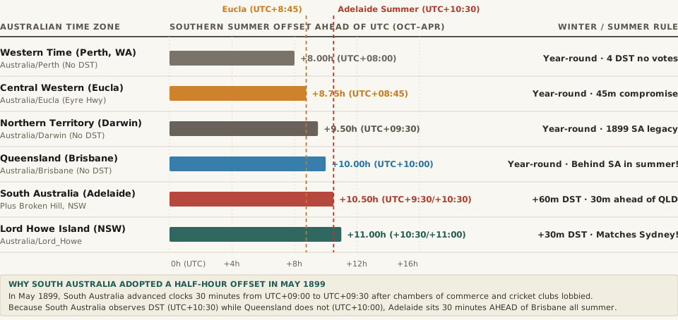
Horizontal comparison chart of Australian time zones during Southern Hemisphere summer (October to April), showing Perth (UTC+8), Eucla (UTC+8:45), Darwin (UTC+9:30), Brisbane (UTC+10), Adelaide (UTC+10:30), and Lord Howe Island (UTC+11)
Figure 1: Southern Hemisphere summer UTC offsets across Australia (October to April), illustrating how South Australia's 30-minute baseline plus Daylight Saving Time pushes Adelaide (UTC+10:30) half an hour ahead of non-DST Queensland (UTC+10:00). Download the full dataset: australia-time-zones-half-hour-adelaide-darwin-eucla-845-and-lord-howe.csv.

1. Why Adelaide and Darwin Sit on a Half-Hour Offset (UTC+09:30): The May 1899 Lobby

When Australia's six colonial governments first standardized civil time in February 1895 (replacing local solar mean time in each city), they adopted three clean, whole-hour zones aligned with Greenwich Mean Time: Western Standard Time (GMT+8) based on the 120°E meridian, Central Standard Time (GMT+9) based on the 135°E meridian for South Australia (which then administered the Northern Territory), and Eastern Standard Time (GMT+10) based on the 150°E meridian for Queensland, New South Wales, Victoria, and Tasmania.

However, Adelaide sits at longitude 138.60°E—meaning that under the 135°E meridian (GMT+9), true solar noon in Adelaide occurred at 11:45 AM, and the sun set 14 minutes earlier on the clock than local solar time. Worse, Adelaide merchants complained that telegraph offices and financial markets in Melbourne and Sydney (GMT+10) closed a full hour before Adelaide's business day ended, while local cricket and Australian rules football associations lobbied for an extra half hour of evening daylight for weekday practice.

As documented in the parliamentary history of Time in Australia, South Australia broke with international whole-hour convention in May 1899 under the Standard Time Act 1898, advancing its clocks by 30 minutes to UTC+09:30 (anchored to the 142.5°E meridian, which actually passes through Victoria and New South Wales east of South Australia's border). When the Northern Territory was separated from South Australia and transferred to the federal government in 1911, Darwin kept the UTC+09:30 offset—and repeated legislative proposals in South Australia to move to either UTC+09:00 or UTC+10:00 (in 1986, 1994, and 2015) have all failed.

“In May 1899, South Australia advanced its clocks by 30 minutes to UTC+09:30 after businesses wanted closer telegraph alignment with Melbourne and local cricketers and footballers lobbied for extra evening practice light.”

2. Why Adelaide Is 30 Minutes Ahead of Brisbane in Summer—and the Broken Hill Exception

During the Southern Hemisphere winter (first Sunday in April to first Sunday in October), mainland Australia follows three ordered bands from west to east: UTC+08:00 (WA), UTC+09:30 (NT and SA), and UTC+10:00 (QLD, NSW, VIC, TAS, ACT). However, Australia's states are sharply divided along latitude lines over Daylight Saving Time:

  • Southern States Observe DST (Oct–Apr): New South Wales, Victoria, Tasmania, the Australian Capital Territory (moving from UTC+10:00 to UTC+11:00 AEDT), and South Australia (moving from UTC+09:30 to UTC+10:30 ACDT) advance their clocks by 60 minutes on the first Sunday in October.
  • Northern & Western States Reject DST: Tropical Queensland (which rejected DST in a 1992 referendum by 54.5% because northern and rural residents did not want hotter, brighter evenings), the Northern Territory, and Western Australia (which rejected DST in four separate referendums in 1975, 1984, 1992, and 2009) remain on standard time year-round.

The result is a famous six-month geographic inversion: from October to April, Adelaide (UTC+10:30) sits 30 minutes ahead of Brisbane (UTC+10:00) despite lying nearly 1,000 km farther west. Furthermore, the Outback mining city of Broken Hill (Yancowinna County) in far-western New South Wales (Australia/Broken_Hill) observes South Australia's UTC+09:30 / UTC+10:30 time zone rather than Sydney's time because it was historically connected by rail and telegraph directly to Adelaide rather than across the Blue Mountains to Sydney.

3. Eucla's UTC+08:45 Highway Zone and Lord Howe Island's 30-Minute DST

Even more remarkable are Australia's two micro-zones at opposite ends of the country. Compare all eight Australian time regimes side by side:

Australian Time Zone or Territory IANA Zone Identifier Standard Offset (Apr–Oct) Summer / DST Offset (Oct–Apr) Summer Clock Shift Reference Meridian & Historical Context
Western Standard Time (Perth, WA) Australia/Perth UTC+08:00 UTC+08:00 (No DST) 0 min 120°E meridian; rejected DST in 1975, 1984, 1992 & 2009 referendums
Central Western Time (Eucla / Eyre Hwy) Australia/Eucla UTC+08:45 UTC+08:45 (No DST) 0 min Splits the 90-min gap between Perth (UTC+8) and South Australia (UTC+9:30)
Central Standard Time (Darwin, NT) Australia/Darwin UTC+09:30 UTC+09:30 (No DST) 0 min 142.5°E meridian; retained South Australia's 1899 half-hour shift in 1911
Central Time w/ DST (Adelaide & Broken Hill) Australia/Adelaide UTC+09:30 UTC+10:30 (ACDT) +60 min May 1899 30-min advance; sits 30 min ahead of Brisbane during Oct–Apr summer
Eastern Standard Time (Brisbane, QLD) Australia/Brisbane UTC+10:00 UTC+10:00 (No DST) 0 min 150°E meridian; 1992 referendum rejected DST (54.5% No)
Eastern Time w/ DST (Sydney / Melbourne) Australia/Sydney UTC+10:00 UTC+11:00 (AEDT) +60 min Covers NSW (except Broken Hill & Lord Howe), VIC, TAS, and ACT
Lord Howe Island Time (NSW Offshore) Australia/Lord_Howe UTC+10:30 UTC+11:00 (LHDT) +30 min ONLY World's only 30-minute DST shift; aligns with Sydney (UTC+11:00) in summer

Central Western Time (UTC+08:45): The 200-Person Eyre Highway Compromise

Along the remote southeastern corner of Western Australia on the Eyre Highway—roughly 1,430 km east of Perth—crossing straight from Western Australia (UTC+08:00) into South Australia (UTC+09:30 in winter, UTC+10:30 in summer) forced truckers and roadhouse staff to jump 90 to 150 minutes across a single state line. To smooth operations between supply bases in both states, five remote roadhouse communities east of Caiguna—Cocklebiddy, Madura, Mundrabilla, Eucla, and Border Village (home to roughly 200 permanent residents)—adopted Central Western Standard Time (CWST, UTC+08:45), splitting the winter gap between Perth and Adelaide exactly in half (45 minutes ahead of Perth, 45 minutes behind Adelaide winter time). Although not formally gazetted by Western Australia's state parliament, official highway signs instruct motorists to adjust their watches by 45 minutes, and the IANA Time Zone Database maintains a dedicated zone identifier (Australia/Eucla) for it.

Lord Howe Island (Australia/Lord_Howe): The World's Only 30-Minute DST Shift

Located 600 kilometers east of Port Macquarie in the Tasman Sea, Lord Howe Island (part of New South Wales, population ~445) instituted Lord Howe Standard Time at UTC+10:30 in 1981 to match its longitudinal position east of the Australian mainland. However, when New South Wales enters Daylight Saving Time (UTC+11:00) each October, island residents wanted their clocks to match Sydney government offices and flight schedules without pushing summer sunsets to 8:30 PM. Their solution: every October, Lord Howe Island advances its clocks by just 30 minutes (from UTC+10:30 to UTC+11:00), and turns them back by 30 minutes every April—making it the only place on the planet with a half-hour Daylight Saving transition.

Check Australian State, Outback, and Island Overlaps in Tempo

When you are scheduling calls across Sydney (Australia/Sydney), Brisbane (Australia/Brisbane), Adelaide (Australia/Adelaide), Darwin (Australia/Darwin), and Perth (Australia/Perth), remembering which states shift in October and which stay fixed—and why Adelaide overtakes Brisbane by 30 minutes every summer—eliminates missed meetings. Open Tempo in your browser to compare live Australian fractional offsets and global workday overlaps side by side.

030 / 56

Why Did Mexico Abolish Daylight Saving Time in 2022 (Except Along the U.S. Border)?

If you schedule a recurring video call between New York or Chicago and Mexico City, you have probably noticed a disorienting seasonal shift: from November to March, Mexico City sits in the exact same time zone as Chicago and Dallas (UTC−06:00, Central Standard Time). Yet on the second Sunday in March, when the United States springs forward into Daylight Saving Time, Mexico City does not move its clocks—leaving it aligned with Denver and El Paso (Mountain Daylight Time, UTC−06:00) for eight months of the year. Even more confusingly, if you travel to Tijuana, Ciudad Juárez, or Reynosa along the northern frontier, clocks do still spring forward and fall back on the exact U.S. schedule, while Cancún on the Caribbean coast remains permanently locked on UTC−05:00.

This split-screen clock architecture is the direct result of Mexico's October 30, 2022 abolition of nationwide Daylight Saving Time under the federal Ley de los Husos Horarios en los Estados Unidos Mexicanos (Law on Time Zones in the United States of Mexico). Here is the complete breakdown of why Mexico adopted nationwide DST in 1996, why it repealed the practice 26 years later after federal energy audits found less than 0.16% electricity savings, and how Mexico's four standard time zones and three special regional exceptions actually work.

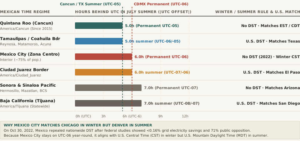
Horizontal comparison chart of Mexico's four standard time zones, the October 2022 DST repeal in Mexico City, the 20-km U.S. border DST exception, Sonora's Arizona alignment, and Quintana Roo's permanent UTC-05 zone
Figure 1: Summer UTC offsets and clock-shift regimes across Mexico following the October 30, 2022 enactment of the Ley de los Husos Horarios. Download the raw dataset: mexico-time-zones-2022-dst-abolition-border-exception-and-cancun.csv.

1. Why Mexico Adopted Nationwide DST in 1996—and Why a 3-to-4-Week Gap Opened in 2007

Although Baja California began observing regional Daylight Saving Time in the mid-20th century to keep pace with California's economy, Mexico did not introduce nationwide Daylight Saving Time (horario de verano) until 1996 under President Ernesto Zedillo. The original rationale was twofold: reducing early-evening residential electricity demand on the national grid (CFE) and keeping Mexican financial markets and manufacturing plants synchronized with the United States following the 1994 enactment of NAFTA.

From 1996 through 2006, Mexico and the United States changed their clocks on the exact same Sundays: advancing one hour on the first Sunday in April and returning to standard time on the last Sunday in October. However, when the U.S. Congress passed the Energy Policy Act of 2005 (taking effect in March 2007), the United States extended its Daylight Saving Time by four to five weeks—starting on the second Sunday in March and ending on the first Sunday in November.

Mexico's interior refused to adopt the longer U.S. schedule because pushing clocks forward in early March left elementary school children across central and southern Mexico commuting in total darkness. Instead, according to historical records on Daylight saving time in Mexico, only Mexican municipalities within 20 kilometers (12.4 miles) of the U.S. border adopted the U.S. March-to-November dates in 2010, while Mexico City and the interior kept the April-to-October dates. For 12 years (2010–2022), businesses coordinating between the U.S. and Mexico City endured a notorious three-to-four-week spring gap (mid-March to early April) and a one-week autumn gap (late October to early November) when the time difference between U.S. cities and Mexico City temporarily shifted by an hour.

“When the U.S. extended Daylight Saving Time into March and November in 2007, interior Mexico stayed on the shorter April-to-October calendar—creating a four-week annual desynchronization window that frustrated cross-border aviation and finance for 15 years.”

2. The October 2022 Repeal: <0.16% Grid Savings and 71% Public Opposition

Why did Mexico finally abolish nationwide Daylight Saving Time on Sunday, October 30, 2022? Like Brazil (which repealed DST in April 2019), most of Mexico lies at tropical and subtropical latitudes between 14.5°N and 24°N, south of the Tropic of Cancer (23.44°N). In Mexico City (19.43°N), natural daylight length barely changes across the year: winter solstice days last roughly 10 hours and 57 minutes, while summer solstice days last 13 hours and 19 minutes. Moving the clock ahead by an hour in summer did not unlock long northern-style evenings; it simply forced workers and students to wake up at what was solar 5:00 AM.

Before introducing the 2022 bill, Mexico's Secretariat of Energy (SENER), the Federal Electricity Commission (CFE), and the Secretariat of Health presented three decisive empirical findings to the Mexican Congress:

  • Negligible Grid Savings (<0.16% of National Consumption): According to federal SENER and FIDE audits cited in the legislative record for Mexico's 2022 DST repeal, nationwide Daylight Saving Time saved roughly 537 gigawatt-hours (GWh) in 2021—representing less than 0.16% of Mexico's total national electricity consumption (worth roughly 1.13 billion pesos, or ~$56 million USD across a population of 128 million). The universal adoption of high-efficiency LED lighting and inverter air conditioning had eroded the evening lighting spike that 1990s models relied upon.
  • Circadian and Cardiovascular Health Costs: Mexico's Secretariat of Health documented spikes in sleep deprivation, daytime fatigue, irritability, and short-term cardiovascular and metabolic disruption during the April spring-forward transition, concluding that biological harm outweighed a 0.16% electricity reduction.
  • 71% Public Support for Abolition: A June–July 2022 national public opinion survey conducted by the Secretariat of the Interior (SEGOB) showed that 71% of Mexican citizens favored abolishing seasonal clock changes permanently.

Mexico's Chamber of Deputies approved the repeal by an overwhelming 445–8 vote in September 2022, the Senate passed it 59–25 on October 26, 2022, and Mexico set its interior clocks back one final time on October 30, 2022.

3. Mexico's Three Major Regional Time Exceptions Explained

While the 2022 law eliminated clock changes for roughly three-quarters of the country, it carefully preserved three geographical exceptions that every traveler, logistics planner, and software engineer needs to understand. Here is the complete reference table across all Mexican regions:

Mexican Time Zone or Border Regime IANA Zone Identifier Winter UTC Offset (Nov–Mar) Summer UTC Offset (Mar–Nov) Annual Clock Shifts Gap vs. U.S. Central Time (CST/CDT) Statutory & Geographic Scope
Zona Sureste (Quintana Roo / Cancún) America/Cancun UTC−05:00 UTC−05:00 0 shifts (Since Feb 2015) +1h in Winter / 0h in Summer Quintana Roo state (Cancún, Cozumel, Tulum) for evening resort daylight
Zona Centro (Mexico City & Interior) America/Mexico_City UTC−06:00 UTC−06:00 0 shifts (Repealed Oct 2022) 0h in Winter / −1h in Summer ~75% of Mexico's population; matches U.S. MDT in summer
Border Zone East (Reynosa / Nuevo Laredo) America/Matamoros UTC−06:00 UTC−05:00 (DST) 2 shifts/yr (U.S. Mar/Nov) 0h year-round (Matches Texas) Municipalities within 20 km of Texas border in Tamaulipas, Nuevo León, Coahuila
Chihuahua Interior (Chihuahua City) America/Chihuahua UTC−06:00 UTC−06:00 0 shifts (Moved Oct 2022) 0h in Winter / −1h in Summer Moved from UTC−07/UTC−06 DST to permanent UTC−06 in Oct 2022
Border Zone West (Ciudad Juárez / Ojinaga) America/Ciudad_Juarez UTC−07:00 UTC−06:00 (DST) 2 shifts/yr (U.S. Mar/Nov) −1h year-round (Matches El Paso) Chihuahua border municipalities synced to El Paso, Texas (MST/MDT)
Zona Pacífico — Sonora (Hermosillo) America/Hermosillo UTC−07:00 UTC−07:00 0 shifts (No DST since 1998) −1h in Winter / −2h in Summer Matches Arizona (America/Phoenix) on permanent UTC−07:00
Zona Noroeste — Baja California (Tijuana) America/Tijuana UTC−08:00 UTC−07:00 (DST) 2 shifts/yr (U.S. Mar/Nov) −2h year-round (Matches CA) Entire state of Baja California synced to California (PST/PDT)

Exception 1: The Northern U.S. Border Zone (Baja California, Ciudad Juárez, Reynosa & Matamoros)

To prevent chaos across deeply integrated cross-border manufacturing complexes (maquiladoras), port-of-entry customs bridges, and binational metropolitan areas like San Diego–Tijuana, El Paso–Ciudad Juárez, and McAllen–Reynosa, the 2022 law explicitly exempted the northern border zone (zona fronteriza). The entire state of Baja California (America/Tijuana) and 37 border municipalities across Chihuahua, Coahuila, Nuevo León, and Tamaulipas continue to observe Daylight Saving Time on the exact U.S. schedule—springing forward at 2:00 AM on the second Sunday in March and falling back at 2:00 AM on the first Sunday in November.

Notice the fascinating quirk in the state of Chihuahua: in October 2022, interior Chihuahua (including Chihuahua City) moved from Mountain Time to permanent Central Standard Time (UTC−06:00). Meanwhile, Ciudad Juárez on the El Paso border initially stayed at UTC−06:00 for four weeks in November 2022 before the Mexican Congress passed an emergency amendment on November 29, 2022 (creating the new IANA zone America/Ciudad_Juarez) so Juárez could drop back to UTC−07:00 in winter and UTC−06:00 in summer, restoring 100% clock alignment with El Paso, Texas.

Exception 2: Sonora (America/Hermosillo) and the Arizona Sync Since 1998

Why did the northwestern state of Sonora opt out of Daylight Saving Time back in 1998, 24 years before the rest of Mexico? Sonora shares a 560-kilometer border and an integrated agricultural and automotive supply chain with the U.S. state of Arizona. Because Arizona (outside the Navajo Nation) has stayed on permanent Mountain Standard Time (UTC−07:00, America/Phoenix) since 1968 to avoid extending blistering 110°F (43°C) desert heat later into the evening, Sonora followed suit in 1998 and has remained on permanent UTC−07:00 ever since.

Exception 3: Quintana Roo and Cancún's Permanent UTC−05:00 Zone Since February 2015

On the opposite side of the country, the Caribbean state of Quintana Roo—home to Cancún, Cozumel, Playa del Carmen, and Tulum—lobbied the federal government for years to create a fourth Mexican time zone: Zona Sureste (UTC−05:00). On February 1, 2015, Quintana Roo permanently advanced its clocks to Eastern Standard Time (UTC−05:00) year-round without DST. By staying on permanent UTC−05:00, Caribbean resorts gain an extra hour of winter afternoon sunlight before sunset (preventing 5:15 PM December sunsets on the beach) and save tourists flying in from New York, Toronto, and Miami from changing their watches during the peak winter travel season.

Verify Mexican Interior, Border, and Resort Offsets Instantly in Tempo

Whether you are scheduling a summer sprint review with engineers in Mexico City and Guadalajara (America/Mexico_City, permanent UTC−06:00), coordinating freight across the Laredo–Nuevo Laredo or El Paso–Ciudad Juárez border bridges (America/Matamoros and America/Ciudad_Juarez), or booking flights into Cancún (America/Cancun, permanent UTC−05:00), relying on pre-2022 time-zone assumptions will put your calendar an hour off between March and November. Open Tempo in your browser to compare exact IANA timezone rules across all four Mexican time zones and border exceptions side by side for any date of the year.

031 / 56

Why Does Brazil Have 4 Time Zones (And Why Did It Abolish Daylight Saving Time in 2019)?

If you scheduled recurring video calls or financial market handoffs between New York or London and São Paulo prior to 2019, you likely remember the annual calendar maze: because North America and Europe spring forward in March while Southern Hemisphere countries spring forward in October or November, the time difference between New York and São Paulo shifted four times every single year—jumping from 1 hour in December, to 2 hours in March, to 3 hours in April, and back to 2 hours in November. As documented in Wikipedia's overview of time in Brazil and daylight saving time in Brazil, that four-way seesaw ended on April 25, 2019, when Brazil permanently abolished Daylight Saving Time (Horário de Verão) and locked its four time zones onto year-round standard time.

Why does Brazil need four separate time zones from UTC-02:00 to UTC-05:00, why did voters in the western state of Acre hold a binding referendum in 2010 to take back their UTC-05:00 clock, and how did afternoon air conditioning kill Brazil's summer time? Here is the complete geographic and grid-engineering breakdown—and how to plan clean North-South America overlap blocks in Tempo.

Brazil's 4 Official Time Zones: From Atlantic Islands (UTC-2) to Acre (UTC-5)

Stretching 4,395 kilometers (2,731 miles) from east to west—from the Atlantic archipelago of Fernando de Noronha at 32°25′ W to the Peruvian border in Acre at 73°59′ W—Brazil spans more than 41° of longitude and divides its territory into four permanent offsets referenced against Brasília Time (BRT):

  1. UTC-02:00 — Fernando de Noronha Time (FNT, BRT+1): Covers the offshore Atlantic islands of Fernando de Noronha (32.42° W), Rocas Atoll, Saint Peter and Saint Paul Archipelago, and Trindade and Martim Vaz (fewer than 0.01% of Brazil's population).
  2. UTC-03:00 — Brasília Time (BRT, BRT+0): The national standard zone covering 93.4% of Brazil's population and all 21 eastern, southern, and northeastern states—including São Paulo (46°38′ W), Rio de Janeiro (43°12′ W), Brasília (47°53′ W), Salvador, Belo Horizonte, and Porto Alegre—plus the eastern state of Pará and Amapá.
  3. UTC-04:00 — Amazon Time (AMT, BRT−1): Covers 6.1% of the population across the central and western interior: Mato Grosso (Cuiabá, 56°06′ W), Mato Grosso do Sul, Rondônia, Roraima, and most of Amazonas (Manaus, sitting almost dead-center on the 60°01′ W meridian, where solar noon occurs within +0.1 minutes of 12:00 PM!).
  4. UTC-05:00 — Acre Time (ACT, BRT−2): Covers 0.5% of the population in the far-western state of Acre (Rio Branco, 67°48′ W) and 13 municipalities in southwestern Amazonas—running on the exact same winter clock as New York, Lima, and Bogotá.
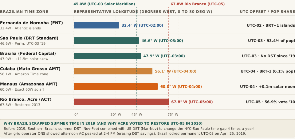
Horizontal bar chart showing representative western longitudes across Brazil's four time zones: Fernando de Noronha (32.4W, UTC-02), Sao Paulo (46.6W, UTC-03), Brasilia (47.9W, UTC-03), Cuiaba (56.1W, UTC-04), Manaus (60.0W, UTC-04), and Rio Branco, Acre (67.8W, UTC-05).
Figure 1: Western longitudes and permanent UTC offsets across Brazil's four official time zones following the April 25, 2019 abolition of Daylight Saving Time. Source: Wikipedia — Time in Brazil & Daylight Saving Time in Brazil.

The 2008–2013 Acre Time War: The Only Time Zone Restored by Popular Referendum

In April 2008, the Brazilian Congress enacted Law 11,662, which abolished Acre Time (UTC-05:00) and forced Acre and southwestern Amazonas to advance their clocks one hour to UTC-04:00 starting June 24, 2008, so that television broadcasts and federal agencies only had to manage two mainland time zones instead of three.

Residents of Acre immediately rebelled: shifting clocks forward pushed morning school and work commutes into pre-dawn darkness. Demand for a reversal was so intense that the Superior Electoral Court authorized a binding state-wide time zone referendum on October 31, 2010 (held alongside Brazil's presidential runoff). By a margin of 56.87% to 43.13%, Acre voters rejected UTC-04:00 and voted to restore their historical clock—leading Congress to pass Law 12,876, which officially returned Acre to UTC-05:00 on November 10, 2013.

After Congress abolished Acre's UTC-05:00 time zone in 2008, 56.87% of Acre voters voted in a 2010 state referendum to get their hour back—making Acre Time one of the only time zones in history restored by direct ballot.

Why Brazil Abolished Daylight Saving Time on April 25, 2019

From 1985 until early 2019, Brazil observed annual summer time—usually from the third Sunday in October (or first Sunday in November) to the third Sunday in February (with a special rule postponing the fallback by one week whenever the third Sunday in February landed on Carnival, as occurred in 2012 and 2015!). However, because equatorial states in Northern and Northeastern Brazil (Manaus, Belém, Recife, Fortaleza, Salvador) experience almost identical 12-hour daylight year-round, they refused to observe DST—splitting Brazil's eastern seaboard into two different time zones every summer.

Even more decisive was the electrical grid data compiled by Brazil's National Electric System Operator (ONS) and Ministry of Mines and Energy:

  • The Shift From Evening Lighting to Afternoon Air Conditioning: In the 1980s and 1990s, Brazil's daily electricity peak occurred between 18:00 and 21:00 when residential lighting and electric showers turned on at dusk; shifting clocks forward cut peak evening demand by up to 4.5%.
  • The 2:00 PM–4:00 PM Thermal Peak: By 2017–2018, widespread commercial and residential air conditioning had moved Brazil's daily power peak to the hottest hours of the afternoon (14:00 to 16:00). Advancing the clock by 1 hour did nothing to reduce afternoon solar heat—and actually increased early-morning cooling and lighting loads.
  • Permanent UTC-03:00 Since April 2019: On April 25, 2019, Decree 9,772 abolished DST nationwide. Today, São Paulo (America/Sao_Paulo) stays on UTC-03:00 all year—only 1 hour ahead of New York during U.S. Daylight Saving Time (March–November) and 2 hours ahead during U.S. standard winter time (November–March).

Complete Reference Table of Brazil's 4 Time Zones and Pre-2019 DST Era

The table below summarizes UTC offsets, population shares, solar noon skews, and U.S. Eastern time gaps across Brazil's time zones (full dataset in brazil-four-time-zones-utc-2-to-utc-5-and-2019-dst-abolition.csv):

Brazilian Time Zone / Era UTC Offset (BRT Ref) Representative City Pop. Share Gap vs. U.S. Eastern (EST / EDT) Solar Skew & Policy Status
Fernando de Noronha (FNT) UTC-02:00 (BRT+1) Fernando de Noronha (32.4° W) < 0.01% +3h (EST) / +2h (EDT) +9.7m solar skew; offshore Atlantic islands
Brasília Time Today (BRT) UTC-03:00 (BRT+0) São Paulo / Brasília (46.6° W) 93.4% +2h (EST) / +1h (EDT) +6.5m skew; permanent year-round since 2019
Pre-2019 Summer DST (BRST) UTC-02:00 (Nov–Feb) South, SE & Central-West ~62% used +3h (EST) — 4 shifts/yr! Abolished Apr 25, 2019 after 2–4 PM AC peak shift
Amazon Time (AMT) UTC-04:00 (BRT−1) Manaus (60.0° W) / Cuiabá 6.1% +1h (EST) / 0h (Same as EDT) +0.1m skew in Manaus; exact 60° W solar match
Acre Time (2008–13 Merger) UTC-04:00 (Forced) Rio Branco (67.8° W) 0.5% +1h (EST) / 0h (EDT) Rejected by 56.87% in 2010 Acre referendum
Acre Time Today (ACT) UTC-05:00 (BRT−2) Rio Branco / Cruzeiro do Sul 0.5% 0h (Same as EST) / -1h (EDT) Restored Nov 10, 2013 under Law 12,876

Scheduling calls across São Paulo, Manaus, New York, and London as Northern Hemisphere clocks shift in March and November? Open Tempo in your browser to compare live UTC offsets and overlapping business hours instantly.

032 / 56

Why Does Russia Have 11 Time Zones (And Why Did It Abandon Permanent Daylight Saving Time in 2014)?

Spanning 171° of longitude across northern Eurasia—from 19°38′ E on the Baltic coast of Kaliningrad to 169°01′ W at Big Diomede Island in the Bering Strait—Russia covers nearly half the circumference of the northern hemisphere. Today, as documented in Wikipedia's comprehensive history of time in Russia and Moscow Time (MSK), the country operates across 11 contiguous time zones stretching from UTC+02:00 to UTC+12:00, with zero Daylight Saving Time (DST) clock changes. Yet between 2010 and 2014, Russia ran one of the largest chronobiological experiments in modern history: compressing the country from 11 time zones down to 9 and locking the entire nation onto permanent year-round Daylight Saving Time—before dark 10:00 AM and 11:00 AM winter mornings forced lawmakers to repeal the law and restore 11 permanent standard time zones on October 26, 2014.

Why does a single country need 11 time zones, why did Russia's 2011–2014 permanent summer-time experiment push Saint Petersburg nearly two full hours ahead of the sun, and how do trains, flights, and software handle Russian time zones today? Here is the complete geographic and historical breakdown—and how you can compare Eurasian offsets in Tempo.

The 1930 "Decree Time" Baseline: Why Russian Clocks Were Already Ahead of the Sun

To understand why Russia's 2011 permanent Daylight Saving Time experiment backfired so severely in winter, you have to go back to June 16, 1930. On that date, the Council of People's Commissars of the USSR issued a decree advancing every clock in the Soviet Union one hour ahead of its natural astronomical time zone—a permanent +1 hour offset known as Decree Time (Декретное время):

  • Moscow (37°37′ E): Sits almost exactly halfway between the 30° E meridian (UTC+02:00) and the 45° E meridian (UTC+03:00). True mean solar time in Moscow is UTC+02:30:29. Even under standard UTC+03:00, Moscow's clocks already lead the sun by +29.5 minutes.
  • Saint Petersburg (30°19′ E): Sits dead-center on the natural 30° E meridian (UTC+02:00), where true solar time is UTC+02:01:17. Because Saint Petersburg is placed inside the Moscow Time Zone (UTC+03:00), its civil clocks already lead true solar time by +58.7 minutes (nearly one full hour) even in standard winter time!
  • Yekaterinburg (60°36′ E) and Novosibirsk (82°56′ E): Sit near the natural UTC+04:00 and UTC+05:30 meridians, but operate on UTC+05:00 and UTC+07:00, running +58 to +88 minutes ahead of solar noon.
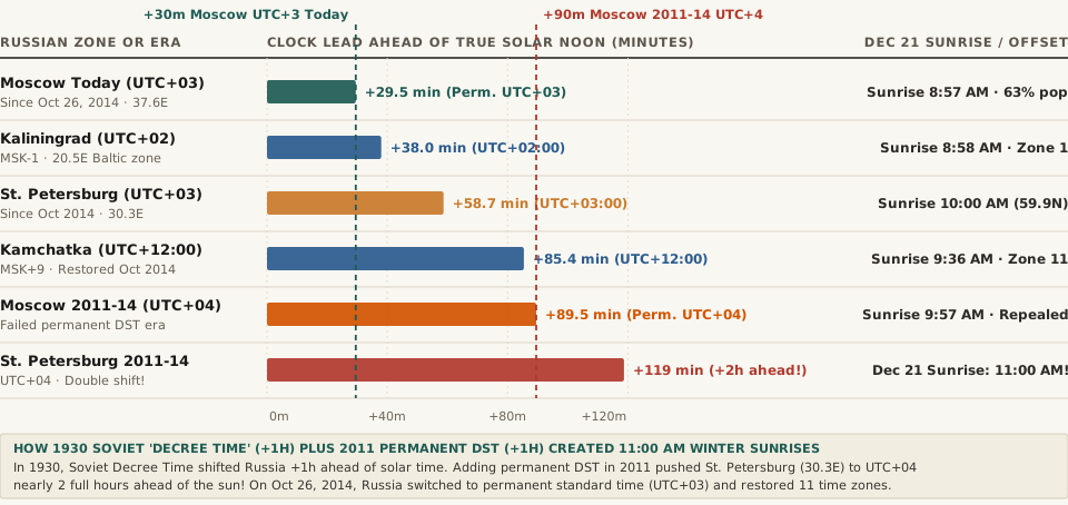
Horizontal bar chart comparing how many minutes civil clocks led true solar noon across Moscow Today (+29.5m), Kaliningrad (+38m), St. Petersburg Today (+58.7m), Kamchatka (+85.4m), Moscow 2011-14 (+89.5m), and St. Petersburg 2011-14 (+119m).
Figure 1: Minutes by which civil clocks led true solar noon across Russian time zones during the 2011–2014 permanent Daylight Saving Time experiment versus the post-October 2014 permanent standard time regime. Source: Wikipedia — Time in Russia & Moscow Time.

What Happened Between 2011 and 2014: 9 Time Zones and 11:00 AM Winter Sunrises

In 2010 and early 2011, then-President Dmitry Medvedev launched two sweeping reforms aimed at simplifying national governance and eliminating twice-yearly clock changes:

  1. Cutting 11 Time Zones Down to 9 (March 2010): The federal government abolished Samara Time (merging Samara and Udmurtia into Moscow Time) and abolished Kamchatka Time (UTC+12:00), forcing Petropavlovsk-Kamchatsky and Chukotka back into Magadan Time—sparking street protests of up to 20,000 residents in Kamchatka who suddenly lost an hour of afternoon daylight.
  2. Locking In Permanent Daylight Saving Time (March 27, 2011): On March 27, 2011, Russians sprang forward 1 hour for summer time and were told they would never turn their clocks back again. Moscow Time (MSK) became permanent UTC+04:00 year-round.

Because Russian regions were already carrying the 1930 Decree Time offset, locking in summer time created permanent double daylight saving time across high-latitude cities (55° N to 60° N) where December daylight lasts only 6 to 7 hours. During the winters of 2011–2012, 2012–2013, and 2013–2014, December 21 sunrise did not occur until 9:57 AM in Moscow and 11:00 AM in Saint Petersburg—forcing millions of schoolchildren and commuters to wake up, travel, and spend the entire morning in pitch darkness. As reported by The Moscow Times, national polling showed support for permanent DST had fallen below 32%.

When Russia locked Moscow Time onto permanent UTC+04:00 between 2011 and 2014, Saint Petersburg clocks ran 119 minutes ahead of the sun—delaying December sunrise until 11:00 AM.

The October 26, 2014 Reversal: Permanent Winter Time and 11 Zones Restored

On July 1, 2014, the State Duma voted overwhelmingly to end the permanent summer-time experiment and undo the 2010 zone mergers. At 02:00 on October 26, 2014:

  • Permanent Standard Time (UTC+03:00 in Moscow): Clocks across most of Russia turned back 1 hour to permanent standard ("winter") time with zero future seasonal transitions.
  • 11 Time Zones Restored: Samara Time (UTC+04:00, MSK+1) and Kamchatka Time (UTC+12:00, MSK+9) were reinstated, restoring Russia's full 11-zone span from UTC+02:00 to UTC+12:00.
  • The 2018 Railway Clock Reform: For nearly a century, every long-distance train timetable and station clock across Russia's 11 time zones displayed Moscow Time (MSK) so Trans-Siberian dispatchers could avoid time zone math. On August 1, 2018, Russian Railways (RZD) finally switched passenger tickets and station announcements to local time, matching commercial aviation.

Complete Reference Table of Russia's Time Zones and 2011–2014 Reforms

The table below compares UTC offsets, Moscow references (MSK), solar noon skews, and December 21 sunrise times across Russia's major zones and the 2011–2014 experiment (full dataset in russia-11-time-zones-utc-2-to-utc-12-and-2011-2014-dst-experiment.csv):

Russian Time Zone or Era UTC Offset (MSK Ref) Representative City Solar Noon Skew Dec 21 Sunrise Population & Policy Status
Kaliningrad Time (USZ1) UTC+02:00 (MSK−1) Kaliningrad (20.51° E) +38.0 min 8:58 AM Westernmost zone (~0.7% of pop.); matches EET
Moscow Time Today (MSK) UTC+03:00 (MSK+0) Moscow (37.62° E) +29.5 min 8:57 AM Home to ~63% of Russia's population; zero DST
Saint Petersburg on MSK UTC+03:00 (MSK+0) St. Petersburg (30.32° E) +58.7 min 10:00 AM Inside MSK; runs ~1h ahead of its 30° E meridian
2011–2014 Permanent DST Era UTC+04:00 (Old MSD) Moscow / St. Petersburg +89.5m / +119m 9:57 AM / 11:00 AM Repealed Oct 26, 2014 after dark-morning backlash
Yekaterinburg & Novosibirsk UTC+05:00 to +07:00 Urals & W. Siberia +58m to +88m 9:35–9:58 AM MSK+2 to MSK+4; retains 1930 +1h Decree offset
Kamchatka Time (PETT) UTC+12:00 (MSK+9) Petropavlovsk (158.65° E) +85.4 min 9:36 AM Easternmost zone (10 hours ahead of Kaliningrad)

Working across permanent no-DST zones like Moscow, Istanbul, or Tokyo alongside seasonal DST zones in Europe and North America? Open Tempo in your browser to track shifting winter and summer time gaps at a glance.