YellowSquared  /  Field notes

Notes from the workshop

56 posts, newest first. Choose an app to narrow the feed.

017 / 56

Why Does Lord Howe Island Shift Its Clocks by Only 30 Minutes for Daylight Saving Time?

Every software engineer who has ever written offset + (is_dst ? 3600 : 0) eventually runs into the single active exception in the IANA Time Zone Database: Australia/Lord_Howe. Located in the Tasman Sea roughly 600 kilometers (370 miles) east of Port Macquarie, New South Wales, Lord Howe Island (population 382) observes Lord Howe Standard Time (LHST, UTC+10:30) during the Southern Hemisphere winter, but shifts its clocks forward by only 30 minutes on the first Sunday in October to Lord Howe Daylight Time (LHDT, UTC+11:00) (Lord Howe Island - Wikipedia; Daylight saving time by country - Wikipedia).

That half-hour transition is not an accident. It reconciles Lord Howe Island's physical longitude in the Tasman Sea with its constitutional status as an unincorporated part of the state of New South Wales. When you compare trans-Pacific flight schedules or Australian state offsets in Open Tempo in your browser, you can see how Lord Howe Island sits 30 minutes ahead of Sydney all winter before locking onto exact Sydney time (UTC+11:00) for the entire six-month summer.
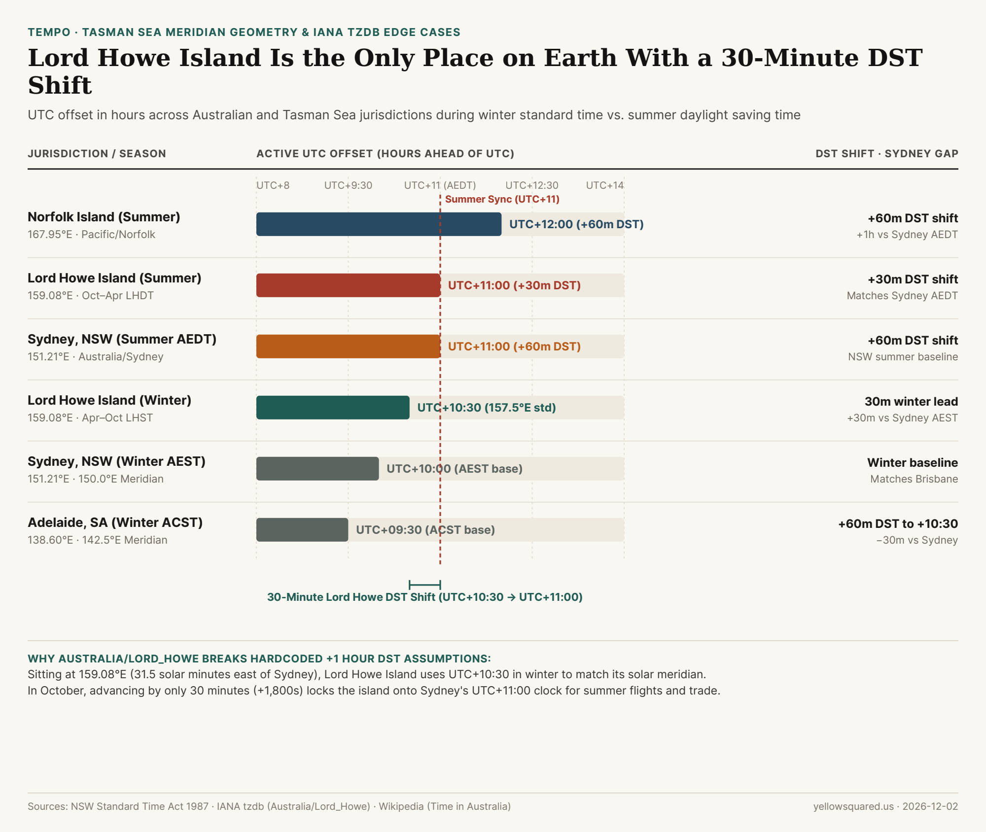
Chart comparing winter and summer UTC offsets across Lord Howe Island, Sydney, Adelaide, Brisbane, and Norfolk Island
Figure 1: Winter standard and summer daylight saving UTC offsets across Australian mainland states and Tasman Sea island territories. Data: lord-howe-island-utc-10-30-to-utc-11-00-half-hour-dst-and-australian-zones.csv (Time in Australia - Wikipedia; Lord Howe Island - Wikipedia).

The 159.08°E Solar Math Behind UTC+10:30

Earth rotates 15° of longitude per hour (4 minutes of solar time per degree), meaning a 30-minute time zone offset corresponds to a 7.5° step between whole-hour meridians:

  • Sydney, New South Wales (151.21°E): Anchored to the 150.0°E meridian for Australian Eastern Standard Time (AEST, UTC+10:00), Sydney sits just 1.21° east of its reference meridian, so mean solar noon occurs about 4.8 minutes before 12:00 PM (Time in Australia - Wikipedia).
  • Lord Howe Island (159.08°E): Positioned 7.87° east of Sydney in the Tasman Sea, sunrise and solar noon arrive 31.5 minutes earlier on Lord Howe Island than in Sydney Harbour.
  • The 157.5°E Half-Hour Meridian (UTC+10:30): Because 159.08°E sits just 1.58° east of the 157.5°E meridian (10.5 × 15°), setting the island's winter standard clock to UTC+10:30 aligns local wall clocks to within 6.3 minutes of true solar noon (Lord Howe Island - Wikipedia).

"At 159.08°E, Lord Howe Island is physically 31.5 solar minutes ahead of Sydney—so a 30-minute winter offset (UTC+10:30) matches the Sun, while a 30-minute summer jump (UTC+11:00) matches Sydney's business day."

How the 1981–1987 New South Wales Legislation Created the 30-Minute Shift

When New South Wales introduced peacetime Daylight Saving Time under the Standard Time Act 1971, Lord Howe Island initially used a standard 60-minute summer shift. Following the passage of the Lord Howe Island Act 1981 and a 1985 Governor's order later codified in the New South Wales Standard Time Act 1987, the state established the modern half-hour rule (Time in Australia - Wikipedia):

  1. Winter Standard Time (First Sunday in April to First Sunday in October): While Sydney, Melbourne, Canberra, and Hobart observe AEST (UTC+10:00), Lord Howe Island observes LHST (UTC+10:30)—preserving an extra half hour of afternoon daylight on the island during winter.
  2. Spring Forward (+30 Minutes on First Sunday in October at 02:00 LHST): When Sydney advances 60 minutes from 02:00 AEST (UTC+10:00) to 03:00 AEDT (UTC+11:00), Lord Howe Island advances 30 minutes from 02:00 LHST (UTC+10:30) to 02:30 LHDT (UTC+11:00) (Daylight saving time by country - Wikipedia).
  3. Autumn Fall Back (−30 Minutes on First Sunday in April at 02:00 LHDT): At the end of summer, Lord Howe Island turns its clocks back 30 minutes from 02:00 LHDT (UTC+11:00) to 01:30 LHST (UTC+10:30).
Australian Jurisdiction IANA Zone ID Winter Standard Summer DST DST Clock Shift Gap vs. Sydney (Win / Sum)
1. Lord Howe Island (Winter) Australia/Lord_Howe UTC+10:30 (LHST) UTC+11:00 (LHDT) +30 min (+1,800 s) +30 min ahead of Sydney
2. Lord Howe Island (Summer) Australia/Lord_Howe UTC+10:30 (LHST) UTC+11:00 (LHDT) +30 min (+1,800 s) 0 min (Same as Sydney)
3. Sydney & Melbourne Australia/Sydney UTC+10:00 (AEST) UTC+11:00 (AEDT) +60 min (+3,600 s) 0 min baseline
4. Adelaide & Broken Hill Australia/Adelaide UTC+09:30 (ACST) UTC+10:30 (ACDT) +60 min (+3,600 s) −30 min behind all year
5. Brisbane, Queensland Australia/Brisbane UTC+10:00 (AEST) UTC+10:00 (No DST) 0 min (0 s) 0 min win / −60 min sum
6. Norfolk Island Pacific/Norfolk UTC+11:00 (NFST) UTC+12:00 (NFDT) +60 min (+3,600 s) +60 min ahead all year

Why Developers Use Australia/Lord_Howe as a Unit-Test Benchmark

In software engineering, Australia/Lord_Howe is the gold-standard unit test for calendar and scheduling libraries: any code that assumes a boolean isDST flag always adds 60 minutes will miscalculate Lord Howe timestamps by 30 minutes every summer, and any code that assumes a 24-hour day is always 23 hours or 25 hours on DST transition Sundays will fail on Lord Howe's 23.5-hour October Sunday and 24.5-hour April Sunday. Notice also how in October, as South Australia (Australia/Adelaide) jumps from UTC+09:30 to UTC+10:30, it steps into the exact UTC+10:30 offset that Lord Howe Island just vacated (Time in Australia - Wikipedia). To inspect live Australian and Pacific time zone overlaps without manual offset math, Open Tempo in your browser.
018 / 56

What Time Zone Are North and South Korea In, and Why Did Pyongyang Use UTC+08:30 from 2015 to 2018?

Both South Korea (Asia/Seoul) and North Korea (Asia/Pyongyang) currently observe Korea Standard Time (KST, UTC+09:00) year-round without Daylight Saving Time. Yet for nearly three years—from August 15, 2015, to May 4, 2018—crossing the Demilitarized Zone (DMZ) required turning your watch back by 30 minutes into Pyongyang Time (PYT, UTC+08:30) (Time in North Korea - Wikipedia). Half a century earlier, South Korea enacted the exact same half-hour offset between March 21, 1954, and August 9, 1961 (Time in South Korea - Wikipedia).

The reason both Korean governments independently experimented with UTC+08:30 comes down to solar geometry. Because Earth rotates 15° every 60 minutes (4 minutes per degree of longitude), the UTC+09:00 meridian lies at 135.0°E—passing directly through Akashi, Japan. The Korean Peninsula, however, sits centered along 127.5°E, the exact mathematical meridian for UTC+08:30 (Time in Korea - Wikipedia). When you compare cross-Pacific engineering standups or East Asian flight schedules in Open Tempo in your browser, both Korean capitals now align with Tokyo at UTC+09:00 while running 32 to 37 minutes ahead of local solar time.

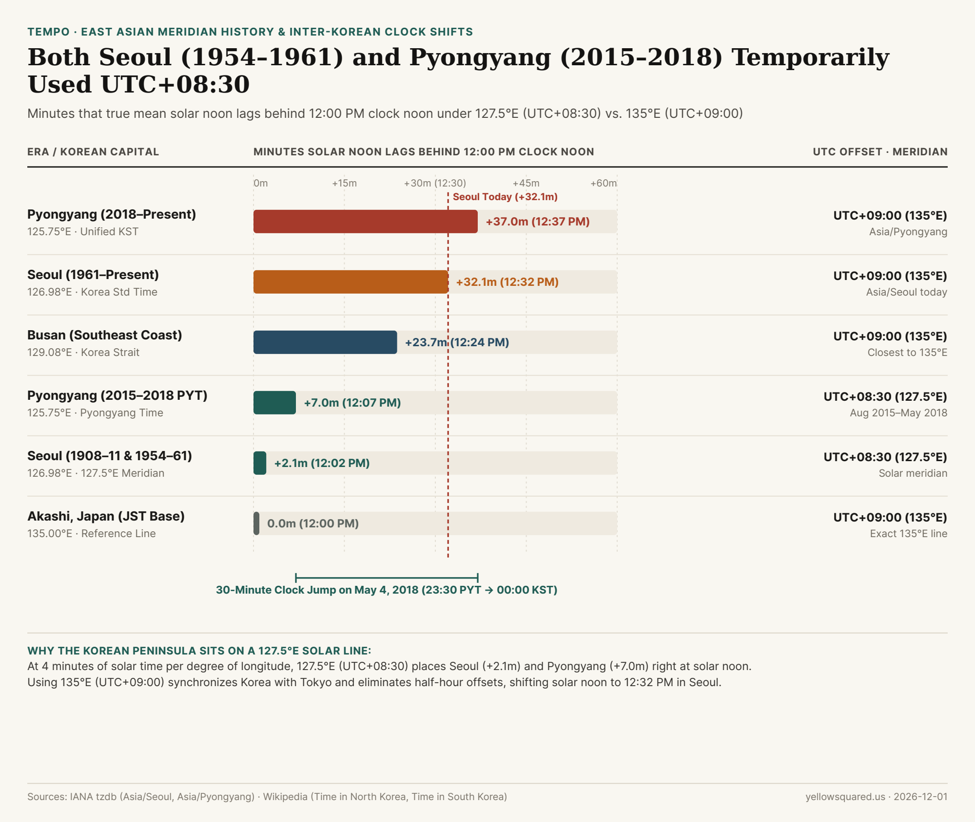
Chart comparing mean solar noon lag behind 12:00 PM clock noon in Pyongyang, Seoul, Busan, and Akashi across UTC+08:30 and UTC+09:00 eras
Figure 1: Mean solar noon lag behind 12:00 PM clock noon across Korean historical eras and cities. Data: korean-peninsula-utc-08-30-vs-utc-09-00-meridian-and-solar-noon-history.csv (Time in North Korea - Wikipedia; Time in South Korea - Wikipedia).

The 127.5°E Peninsula Meridian vs. the 135.0°E Akashi Meridian

In standard solar timekeeping, each one-hour UTC offset spans 15° of longitude, and each 30-minute offset sits midway between whole-hour meridians. Multiplying any city's longitude offset from its governing meridian by 4 minutes per degree reveals the exact gap between 12:00 PM on a wall clock and true mean solar noon:

  • Pyongyang (125.75°E under UTC+09:00 / 135.0°E): Sitting 9.25° west of the 135.0°E meridian, the sun reaches its highest point 9.25 × 4 = 37.0 minutes after clock noon, at 12:37 PM KST (Time in North Korea - Wikipedia).
  • Seoul (126.98°E under UTC+09:00 / 135.0°E): Sitting 8.02° west of 135.0°E, mean solar noon arrives 8.02 × 4 = 32.1 minutes after clock noon, at 12:32 PM KST (Time in South Korea - Wikipedia).
  • Busan (129.08°E under UTC+09:00 / 135.0°E): On the southeastern coast along the Korea Strait, the lag narrows to 5.92 × 4 = 23.7 minutes (solar noon at 12:24 PM KST).
  • Seoul and Pyongyang under UTC+08:30 (127.5°E): When governed by the 127.5°E meridian, Seoul sits just 0.52° west of the reference line (solar noon at 12:02 PM, a +2.1 minute lag) and Pyongyang sits 1.75° west (solar noon at 12:07 PM, a +7.0 minute lag) (Time in Korea - Wikipedia).

"When a peninsula centered at 127.5°E uses a 135°E clock, every morning commute happens 30 minutes earlier in the solar cycle in exchange for zero half-hour friction with Tokyo and regional aviation."

Six Historical Clock Transitions Across Korea (1908–Present)

The IANA Time Zone Database maintains two separate zone identifiers—Asia/Seoul and Asia/Pyongyang—specifically because the two capitals diverged twice after 1945:

  1. April 1, 1908 – December 31, 1911 (UTC+08:30): The Korean Empire established its first national standard time anchored to the 127.5°E meridian (Time in South Korea - Wikipedia).
  2. January 1, 1912 – March 20, 1954 (UTC+09:00): Following the 1910 annexation, the Governor-General of Korea shifted clocks forward 30 minutes to UTC+09:00 to match Japan Standard Time (Time in North Korea - Wikipedia).
  3. March 21, 1954 – August 9, 1961 (South Korea at UTC+08:30): After the Korean War armistice, South Korean President Syngman Rhee ordered clocks turned back 30 minutes to UTC+08:30 to restore the pre-1912 Korean Empire meridian, creating the first 30-minute split across the DMZ (Time in South Korea - Wikipedia).
  4. August 10, 1961 – Present (South Korea at UTC+09:00): Less than three months after the May 1961 military coup, Park Chung Hee's Supreme Council for National Reconstruction returned South Korea to UTC+09:00 to align regional military operations and trade with US forces and Japan (Time in South Korea - Wikipedia). South Korea also briefly tested Daylight Saving Time (UTC+10:00) during 1948–1951, 1955–1960, and for the 1987–1988 Seoul Olympic Games, before abolishing DST permanently after October 1988.
  5. August 15, 2015 – May 4, 2018 (North Korea at UTC+08:30): By decree of the Supreme People's Assembly on August 5, 2015, North Korea turned clocks back 30 minutes on the 70th anniversary of Liberation Day to establish Pyongyang Time (PYT, UTC+08:30), creating a 30-minute offset at the jointly operated Kaesong Industrial Region (Time in North Korea - Wikipedia).
  6. May 5, 2018 – Present (Unified UTC+09:00): Following the April 2018 Inter-Korean Summit at Panmunjom—where two wall clocks in the Peace House showed Seoul and Pyongyang 30 minutes apart—North Korea advanced its clocks by 30 minutes at 23:30 on May 4, 2018 to jump directly to 00:00 on May 5, 2018 (UTC+09:00) (Time in North Korea - Wikipedia).
Korean Era or City Active UTC Offset Standard Meridian City Longitude Mean Solar Noon Solar Lag vs. 12:00 PM
1. 1908–1911 Korean Empire UTC+08:30 127.50°E 126.98°E (Seoul) 12:02 PM +2.1 min behind noon
2. 1912–1954 Colonial & War Era UTC+09:00 135.00°E 126.98°E (Seoul) 12:32 PM +32.1 min behind noon
3. 1954–1961 South Korea (ROK) UTC+08:30 127.50°E 126.98°E (Seoul) 12:02 PM +2.1 min behind noon
4. 1961–Present Seoul (ROK) UTC+09:00 (KST) 135.00°E 126.98°E (Seoul) 12:32 PM +32.1 min behind noon
5. 2015–2018 Pyongyang (PYT) UTC+08:30 (PYT) 127.50°E 125.75°E (Pyongyang) 12:07 PM +7.0 min behind noon
6. 2018–Present Pyongyang (DPRK) UTC+09:00 (KST) 135.00°E 125.75°E (Pyongyang) 12:37 PM +37.0 min behind noon

How to Handle Korean Timestamps and Cross-Pacific Scheduling

If your software parses historical Asian log files, financial market ticks, or satellite imagery recorded between August 15, 2015, and May 4, 2018, never hardcode Korea as a static +09:00 offset. Always bind timestamps to the explicit IANA zone identifier (Asia/Seoul or Asia/Pyongyang) so historical tzdb transition tables automatically apply the +08:30 window when needed. Because neither South Korea nor Japan observes Daylight Saving Time, Seoul stays locked at a 16-hour gap ahead of Seattle/San Francisco during PDT (UTC−07:00) and a 17-hour gap during PST (UTC−08:00). To compare live working hours across Seoul, Tokyo, Taipei, and U.S. time zones at a glance, Open Tempo in your browser.

019 / 56

Why Did Venezuela Use a 30-Minute Time Zone (UTC−04:30)—And Why Did It Switch Back to UTC−04:00 in 2016?

Today, Venezuela observes Venezuelan Standard Time (UTC-04:00, VET) year-round, matching Bolivia, Puerto Rico, and eastern winter clocks during U.S. Daylight Saving Time. Yet if you inspect historical logs in the IANA time zone database for America/Caracas, you will find one of the most unusual back-and-forth clock experiments in modern history: for over half a century from 1912 to 1964, and again for eight and a half years from December 9, 2007 to April 30, 2016, Venezuela detached itself from every whole-hour time zone in South America to run on its own 30-minute offset at UTC-04:30.

Reader outcome: By the end of this guide, you will understand the astronomical geometry behind Venezuela's two rival meridians (67°30'W at Villa de Cura vs. 60°00'W at Punta de Playa), why President Hugo Chávez moved clocks back 30 minutes in 2007, and why a severe hydroelectric drought at the Guri Dam forced President Nicolás Maduro to advance clocks 30 minutes on May 1, 2016.

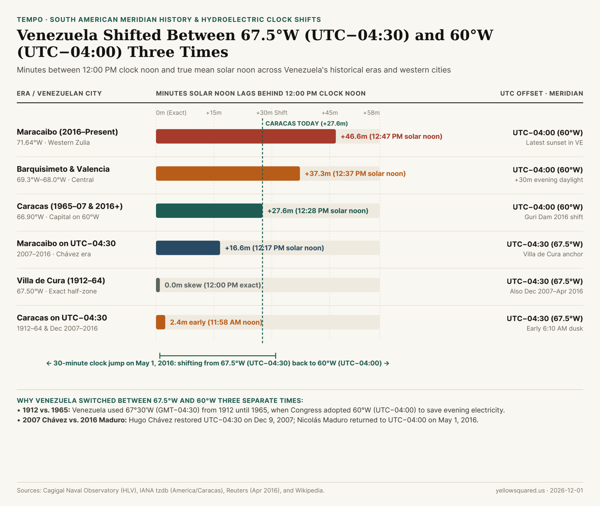
Chart comparing solar noon skew across Venezuela's 1912-1964, 1965-2007, 2007-2016, and 2016-present time zone eras in Caracas and Maracaibo
Anchored to the 67°30'W Villa de Cura meridian (UTC−04:30), solar noon in Caracas occurred at 11:58 AM. Shifting to the 60°W meridian (UTC−04:00) in 1965 and again in May 2016 moved evening sunset 30 minutes later across Caracas and Maracaibo. Data: Download CSV dataset.

The Two Meridians of Venezuela: 67°30'W (Villa de Cura) vs. 60°00'W (Punta de Playa)

Look at a map of northern South America, and Venezuela's territory stretches almost symmetrically between 60°W longitude at its eastern Atlantic delta ( bordering Guyana) and 73°W longitude along its western border with Colombia—Sitting squarely inside the 15-degree longitudinal band between the 60°W (UTC-04:00) and 75°W (UTC-05:00) standard meridians.

When the Venezuelan government created the Hora Legal de Venezuela (HLV, administered by the Cagigal Naval Observatory in Caracas) in 1912, astronomers chose the exact geometric midpoint between 60°W and 75°W: the 67°30'W (67.5°W) meridian passing through the central town of Villa de Cura in Aragua state. Multiplying 67.5° × 4 solar minutes per degree equals exactly 270 minutes = 4 hours and 30 minutes behind Greenwich (GMT-04:30). Because Caracas sits at 66°54'W (66.90°W), just 36 arcminutes east of Villa de Cura, GMT-04:30 placed true mean solar noon in Caracas at 11:57:36 AM—within 144 seconds of 12:00 PM!

Why did Venezuela abandon that astronomical fit in January 1965? As historical records from the Cagigal Naval Observatory document, two forces converged in the mid-1960s:

  • International Integer-Hour Standardization: International aviation, maritime, and telecommunications bodies urged nations to align with whole-hour multiples of 15° longitude—specifically the 60°W meridian passing through Punta de Playa in Venezuela's eastern Delta Amacuro state (UTC-04:00).
  • The La Electricidad de Caracas Grid Study: Engineers at La Electricidad de Caracas (the capital's electric utility) calculated that advancing the national clock by +30 minutes from GMT-04:30 to UTC-04:00 would still leave plenty of morning daylight near the Equator (`10.5°N` latitude) while adding 30 extra minutes of natural afternoon sunlight, cutting residential and commercial lighting demand at the 6:00 PM–7:00 PM evening peak.

Sitting at 10.5°N latitude, Caracas gets roughly 11.5 to 12.5 hours of daylight all year—so shifting between 67.5°W (UTC−04:30) and 60°W (UTC−04:00) acts like a permanent 30-minute Daylight Saving switch.

2007 vs. 2016: Why Chávez Subtracted 30 Minutes and Maduro Added It Back

After 42 years on UTC-04:00, President Hugo Chávez announced in late 2007 that Venezuela would return to the 67°30'W Villa de Cura meridian. Chávez argued that under UTC-04:00, elementary schoolchildren—especially in western states like Zulia (Maracaibo, 71.64°W, where solar noon on UTC-04:00 occurred at 12:47 PM)—were waking up and commuting to 7:00 AM classes before dawn. At 3:00 AM on December 9, 2007, Venezuela turned its clocks back 30 minutes to UTC-04:30, requiring emergency patches across operating systems, airlines, and financial terminals worldwide.

Eight and a half years later, the exact electricity physics predicted by La Electricidad de Caracas in 1965 returned with a vengeance. In early 2016, a severe El Niño drought dropped water levels at the Simón Bolívar Hydroelectric Plant (Guri Dam)—which supplied roughly two-thirds of Venezuela's electrical power—near its critical minimum turbine intake elevation. Because UTC-04:30 caused sunset in Caracas to occur around 6:10 PM in winter and 6:50 PM in summer, millions of households switched on lights, televisions, and air conditioners simultaneously while offices were still running:

Venezuelan Era / City Active Offset Reference Meridian City Longitude Mean Solar Noon Solar Lag vs. 12:00 PM
1912–1964 (Villa de Cura) GMT-04:30 67°30'W 66.90°W (Caracas) 11:58 AM HLV -2.4 min ahead of noon
1965–2007 (Punta de Playa) UTC-04:00 60°00'W 66.90°W (Caracas) 12:28 PM VET +27.6 min behind noon
Dec 2007–Apr 2016 (Chávez) UTC-04:30 67°30'W 66.90°W (Caracas) 11:58 AM VET -2.4 min ahead of noon
May 2016–Present (Caracas) UTC-04:00 60°00'W 66.90°W (Caracas) 12:28 PM VET +27.6 min behind noon
Maracaibo (Western Zulia) UTC-04:00 60°00'W 71.64°W (Maracaibo) 12:47 PM VET +46.6 min behind noon
Bogotá, Colombia (Neighbor) UTC-05:00 75°00'W 74.07°W (Bogotá) 11:56 AM COT -3.7 min (1 hr behind VE)

On April 15, 2016, President Nicolás Maduro announced that Venezuela would reverse the 2007 time zone change to curb evening electricity demand. On May 1, 2016 at 02:30:00 local time, clocks across Venezuela sprang forward 30 minutes to 03:00:00 (UTC-04:00), leaving Newfoundland (America/St_Johns, UTC-03:30) as the only remaining half-hour time zone in the Americas. To compare Caracas against New York, Bogotá, Santiago, and São Paulo across seasonal DST shifts, Open Tempo in your browser.

020 / 56

Why Are the Chatham Islands 45 Minutes Ahead of New Zealand (UTC+12:45 and UTC+13:45)?

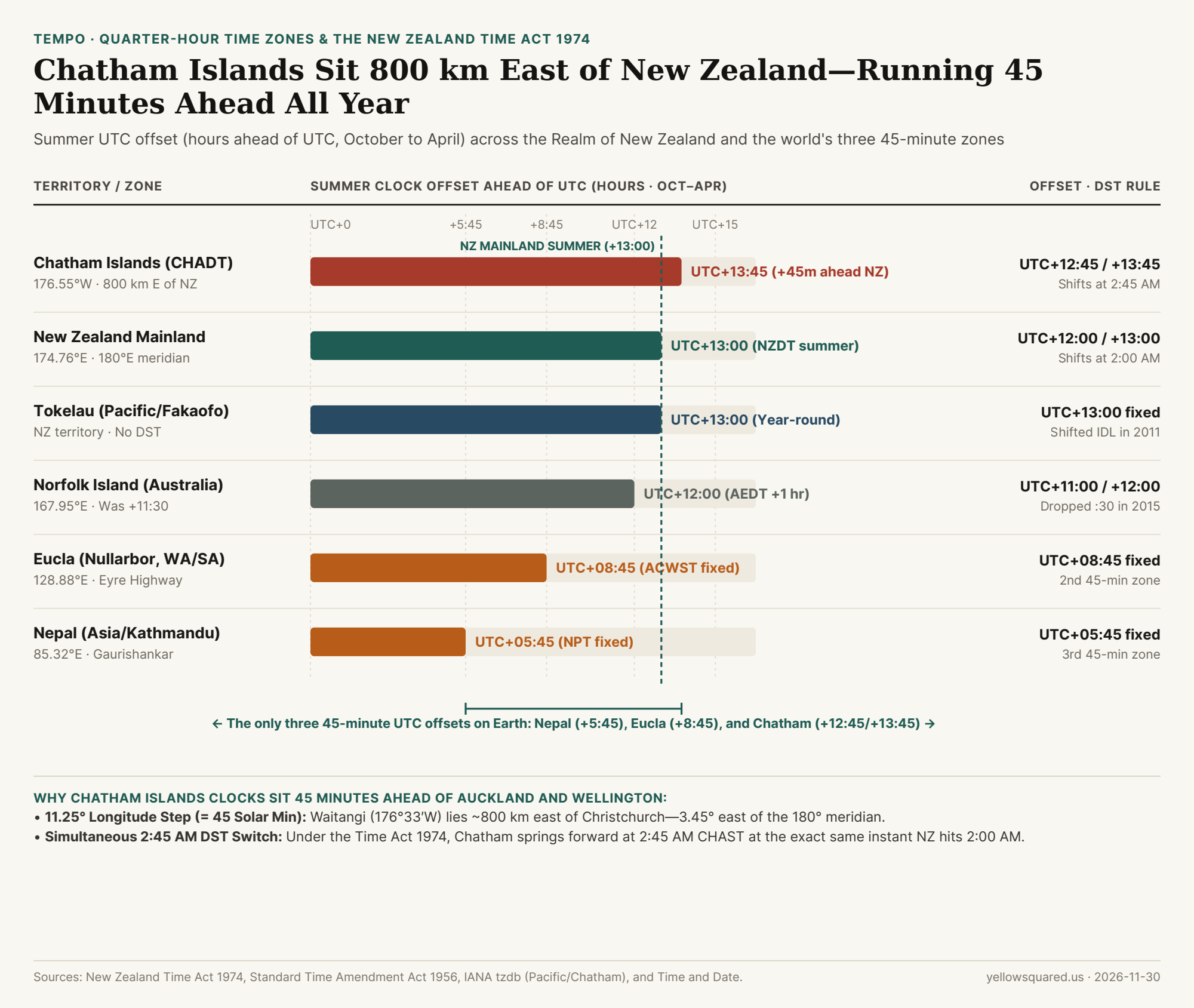
Open the IANA time zone database and sort every civil clock on Earth by its minute offset from Coordinated Universal Time (UTC), and nearly all 400+ regions land on `:00` or `:30`. Only three places on the planet use a :45-minute offset: Nepal (UTC+05:45), Australia's unofficial Nullarbor highway strip around Eucla (UTC+08:45), and New Zealand's Chatham Islands (Pacific/Chatham), which observe Chatham Island Standard Time (UTC+12:45, CHAST) in winter and Chatham Island Daylight Time (UTC+13:45, CHADT) from late September to early April. Even better: because the Chathams sit 45 minutes ahead of Auckland and Wellington, New Zealand's Daylight Saving Time law shifts Chatham clocks at 2:45 AM so the entire Realm of New Zealand springs forward and falls back at the exact same physical second.

Reader outcome: By the end of this guide, you will know the exact solar longitude math that put the Chatham Islands 45 minutes ahead of mainland New Zealand, why the International Date Line bends around `176°33'W` to keep the Chathams on the same calendar date as Wellington, and how all three `:45`-minute time zones on Earth work.

Chart comparing the Chatham Islands UTC+12:45 and UTC+13:45 time zone against mainland New Zealand, Tokelau, Norfolk Island, Eucla, and Nepal
Located 800 km (500 miles) east of New Zealand's South Island across the 180th meridian, the Chatham Islands observe UTC+12:45 in winter and UTC+13:45 in summer—keeping a constant 45-minute lead over Auckland and Wellington. Data: Download CSV dataset.

The Solar Math: Why Waitangi (176°33'W) Sits 45 Minutes East of New Zealand

In 1868, New Zealand became the first country in the world to adopt a nationwide standard time by anchoring **New Zealand Mean Time (NZMT)** to the 172°30'E meridian—which runs through the South Island just west of Christchurch and sits exactly 11 hours and 30 minutes (GMT+11:30) ahead of Greenwich. Meanwhile, the Chatham Islands—an archipelago of about 600–800 residents centered on Waitangi—lie roughly 800 kilometers (500 miles) east of Christchurch.

Look at Waitangi's coordinates on a map, and you immediately notice a geographic twist: Waitangi sits at 176°33'W longitude—meaning it actually lies 3 degrees and 27 arcminutes east of the 180° antimeridian in the Western Hemisphere. If you calculate the longitudinal span from New Zealand's original 172°30'E meridian eastward across the 180° line to Waitangi (183°27'E equivalent):

  • The 1868 45-Minute Gap: The longitudinal distance from 172°30'E to 176°33'W is 10°57' (nearly 11.25°). Since Earth rotates 1° every 4 minutes, 11.25° × 4 minutes/degree = 45.0 minutes of true solar time. Thus, in 1868, the Chatham Islands standardized their local time at GMT+12:15—45 minutes ahead of mainland New Zealand's GMT+11:30.
  • The 1945–1956 Shift to UTC+12:45: During World War II, mainland New Zealand advanced its clocks by 30 minutes to GMT+12:00 (180°E meridian) and made the change permanent under the Standard Time Act 1945. To preserve their 45-minute eastern solar lead over the mainland, Chatham Islanders advanced their clocks by 30 minutes as well, to UTC+12:45—codified into statute by the Standard Time Amendment Act 1956 (effective January 1, 1957) and carried forward in the Time Act 1974.
  • Why the International Date Line Bulges East: Although 176°33'W is technically west of Greenwich's antimeridian, the International Date Line jogs eastward around the Chatham Islands (just as it does around Kiribati and Samoa) so the islands never sit 23 hours and 15 minutes behind Wellington on the previous calendar day.

When New Zealand moved its permanent clock 30 minutes forward from GMT+11:30 to UTC+12:00 in 1946, the Chatham Islands moved 30 minutes forward too—turning GMT+12:15 into today's UTC+12:45.

How the 2:45 AM Daylight Saving Transition Works Across the Realm of New Zealand

Under the New Zealand Time Act 1974 and the New Zealand Daylight Time Order 2007, Daylight Saving Time runs from the last Sunday in September to the first Sunday in April. Most countries with multiple time zones (such as the United States and Canada) switch each zone at 2:00 AM local wall-clock time, which staggers the transitions an hour apart. New Zealand instead synchronizes the transition at the exact same UTC instant (`14:00 UTC` Saturday):

  • Spring Forward (Last Sunday in September): At 2:00 AM NZST (`UTC+12:00`), mainland New Zealand jumps to 3:00 AM NZDT (`UTC+13:00`). At that exact same moment, clocks on the Chatham Islands read 2:45 AM CHAST (`UTC+12:45`) and jump to 3:45 AM CHADT (`UTC+13:45`).
  • Fall Back (First Sunday in April): At 3:00 AM NZDT (`14:00 UTC`), mainland clocks roll back to 2:00 AM NZST, while Chatham clocks simultaneously roll back from 3:45 AM CHADT to 2:45 AM CHAST—ensuring there is never a 15-minute window where the mainland/Chatham time difference changes from 45 minutes.
Jurisdiction / Territory IANA Time Zone Longitude / Meridian Standard Offset Summer DST Offset DST Transition Clock Rule
Chatham Islands (Waitangi) Pacific/Chatham 176.55°W (183.45°E) UTC+12:45 (CHAST) UTC+13:45 (CHADT) Switches at 02:45 CHAST / 03:45 CHADT
New Zealand Mainland (Auckland) Pacific/Auckland 174.76°E (180°E) UTC+12:00 (NZST) UTC+13:00 (NZDT) Switches at 02:00 NZST / 03:00 NZDT
Tokelau (NZ Dependency) Pacific/Fakaofo 171.2°W (West of IDL) UTC+13:00 (TKT) UTC+13:00 (No DST) Skipped Dec 30, 2011; 45m behind CHADT
Cook Islands (Rarotonga) Pacific/Rarotonga 159.77°W (East of IDL) UTC-10:00 (CKT) UTC-10:00 (No DST) 22h 45m / 23h 45m behind Chatham Islands
Eucla & Nullarbor (Australia) Australia/Eucla 128.88°E (Eyre Hwy) UTC+08:45 (ACWST) UTC+08:45 (No DST) Unofficial 45-minute highway border zone
Nepal (Kathmandu) Asia/Kathmandu 85.32°E (86.25°E) UTC+05:45 (NPT) UTC+05:45 (No DST) Adopted 1986; 15 minutes ahead of India

Why Software Developers Use Pacific/Chatham to Test Time-ZoneParsers

In software engineering, Pacific/Chatham is the ultimate stress test for calendar and cron schedulers: it combines a non-integer 45-minute offset, a Southern Hemisphere summer DST schedule (where DST spans across New Year's Day from September to April), and a non-2:00 AM transition timestamp (02:45 / 03:45). Any code that stores UTC offsets as whole-hour integers or assumes DST only occurs between March and November will fail on Pacific/Chatham. To compare Auckland, Waitangi, Kathmandu, and Eucla offsets side by side across any date of the year, Open Tempo in your browser.

021 / 56

Why Is There a 3.5-Hour Time Jump at the Afghanistan–China Border—The Largest Land Border Time Difference on Earth?

Normally, crossing an international land border changes your watch by at most one hour—or not at all. Even if you drive across the 18th-century meridian mismatch between Spain (UTC+01:00) and Portugal (UTC+00:00), or cross the Arctic frontier from Norway (UTC+01:00) into Russia's Murmansk Oblast (UTC+03:00) in winter, the jump is only one or two hours. Yet high in the Pamir and Hindu Kush mountains of Central Asia sits a 92-kilometer (57-mile) frontier where a single stride across the border watershed advances official civil time by 3 hours and 30 minutes. As documented in the geographic and treaty records of Wakhjir Pass and the Afghanistan–China border, stepping from the eastern tip of Afghanistan's Wakhan Corridor (UTC+04:30) into China's Xinjiang Uygur Autonomous Region (UTC+08:00) produces the sharpest terrestrial time-zone jump anywhere on Earth.

How did Afghanistan and China end up sharing a 57-mile border in 1895, what is the true solar time at 74°29'E longitude on the crest of the 4,923-meter (16,152-foot) Wakhjir Pass, and why do China's borders hold the top four terrestrial clock-jump records in the world? Here is the complete geodesy and border history.

1. The 1895 Wakhan Corridor & The 1963 Sino-Afghan Boundary Treaty

Look at a map of northeastern Afghanistan, and you will see a narrow panhandle of land—just 16 to 64 kilometers wide and 350 kilometers long—stretching eastward between Tajikistan to the north and Pakistan to the south until it dead-ends into China. Known as the Wakhan Corridor, this high-altitude valley was created in 1895 during the "Great Game" by an Anglo-Russian boundary commission so that the Russian Empire (in modern Tajikistan) and the British Indian Empire (in modern Pakistan) would never touch directly (Wikipedia — Afghanistan–China border).

On November 22, 1963, the Kingdom of Afghanistan and the People's Republic of China signed the formal Boundary Treaty demarcating their 92-kilometer (57-mile) frontier along the Mustagh Range watershed from the Pakistan tripoint at 5,630 meters to the Tajikistan tripoint on Povalo-Shveikovskogo / Kokrash Kol Peak at 5,698 meters. The only potentially navigable route across that glaciated wall is the ancient Silk Road saddle of Wakhjir Pass (4,923 m / 16,152 ft), connecting Wakhan District in Afghanistan's Badakhshan Province with Taxkorgan Tajik Autonomous County in Kashgar Prefecture, Xinjiang.

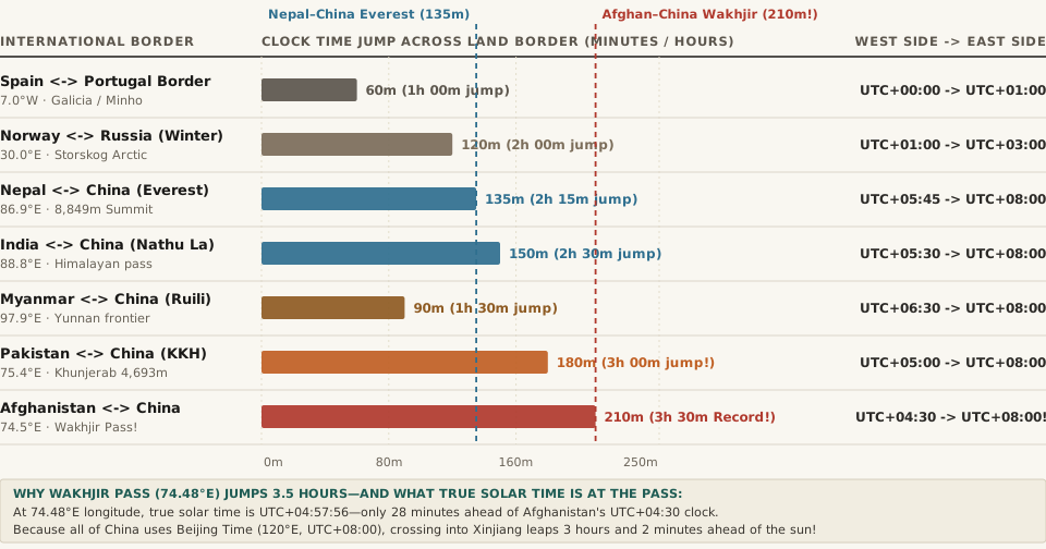
Chart comparing official clock time jumps in minutes across seven major international land borders: Spain-Portugal (60m), Myanmar-China (90m), Norway-Russia Winter (120m), Nepal-China Everest (135m), India-China (150m), Pakistan-China Khunjerab Pass (180m), and Afghanistan-China Wakhjir Pass (210m / 3.5 hours)
Figure 1: Official clock time jump (in minutes) across the world's steepest international land border time-zone boundaries (Wikipedia — Wakhjir Pass; Afghanistan–China Border).

2. The Solar Longitude Math at 74.48°E: Why China's Clock Is 3 Hours Ahead of the Sun

Why do the clocks on opposite sides of Wakhjir Pass disagree by 3 hours and 30 minutes (210 minutes)? Let's compare both countries' legal time zones against the actual position of the Sun at the pass's coordinates (37.0872°N, 74.4842°E, per Wikipedia's Wakhjir Pass survey):

  • True Local Mean Solar Time at Wakhjir Pass (UTC+04:57:56): Because Earth rotates 1° every 4 minutes (15° per hour), a meridian at 74.4842°E sits 74.4842 × 4 = 297.94 minutes—or 4 hours, 57 minutes, and 56 seconds—ahead of Greenwich (UTC+00:00).
  • The Afghan Side (Asia/Kabul, UTC+04:30): Afghanistan observes a nationwide half-hour offset of UTC+04:30 year-round (centered on 67.5°E near Kabul at 69.2°E). At Wakhjir Pass on the far eastern tip of the country, UTC+04:30 sits within just 27 minutes and 56 seconds of true solar noon.
  • The Chinese Side (Asia/Shanghai, UTC+08:00): Although China spans more than 60 degrees of longitude—and used five separate time zones (UTC+05:30 Kunlun Time through UTC+08:30 Changbai Time) between 1918 and 1949—since 1949 the entire People's Republic of China has mandated a single official national standard time: Beijing Time (UTC+08:00), anchored to the 120°E meridian near the Yellow Sea coast, 45.5° of longitude (nearly 4,000 kilometers) east of Wakhjir Pass!
  • The 3.5-Hour Discontinuity & Unofficial Xinjiang Time (UTC+06:00): Because official Chinese time (UTC+08:00) sits 3 hours and 2 minutes ahead of the sun at Wakhjir Pass, stepping from the Afghan cairn at 9:00 AM instantly advances official civil time to 12:30 PM on the Chinese side. In daily life across Kashgar and Taxkorgan, many local Uyghur and Tajik residents informally observe Xinjiang Time (UTC+06:00)—or shift their Beijing-Time work and school schedules two hours later (10:00 AM to 7:00 PM) so solar noon aligns with lunch.

"With a difference of 3.5 hours, the Afghanistan–China border has the sharpest official change of clocks of any international frontier (UTC+04:30 in Afghanistan to UTC+08:00, in China)."

3. Complete Data Table: The World's Largest Land-Border Time Jumps

Because China locks a continent-sized landmass to a single eastern meridian (UTC+08:00), its western and southern frontiers account for the top five land-border clock jumps on Earth. The reproducible table below—matching the companion CSV (afghanistan-china-wakhjir-pass-3-5-hour-border-and-global-land-time-jumps.csv)—ranks the steepest terrestrial time-zone boundaries worldwide:

International Land Border Western / Earlier Side Eastern / Later Side Crossing Longitude Time Jump (Min) Time Jump (Hr) Border Crossing & Solar Note
Afghanistan ↔ China (Wakhjir Pass) Afghanistan (UTC+04:30) China (UTC+08:00) 74.48°E (4,923 m) 210 min 3h 30m (Record) 92-km Wakhan frontier; sharpest land clock jump on Earth
Pakistan ↔ China (Khunjerab Pass) Pakistan (UTC+05:00) China (UTC+08:00) 75.43°E (4,693 m) 180 min 3h 00m Highest paved international border crossing (Karakoram Hwy)
Tajikistan / Kyrgyzstan ↔ China Tajikistan (UTC+05:00) / KG (+06) China (UTC+08:00) 73.6°E–78.0°E 180 / 120 min 3h 00m / 2h 00m Kulma Pass (+05 to +08 = 3h) & Torugart Pass (+06 to +08 = 2h)
India ↔ China (Nathu La / LAC) India (UTC+05:30) China (UTC+08:00) 78.0°E–97.0°E 150 min 2h 30m Two single-time-zone nations meeting across the Himalayas
Nepal ↔ China (Mount Everest) Nepal (UTC+05:45) China (UTC+08:00) 86.93°E (8,849 m) 135 min 2h 15m Stepping across the summit ridge of Mt. Everest jumps 2h 15m
Norway ↔ Russia (Storskog, Winter) Norway (UTC+01:00 CET) Russia Murmansk (UTC+03:00) 30.00°E 120 min 2h 00m (1h DST) Europe's steepest land border clock jump during winter
Myanmar ↔ China (Ruili / Muse) Myanmar (UTC+06:30) China (UTC+08:00) 97.85°E 90 min 1h 30m Half-hour Myanmar time meeting Beijing Time in Yunnan

Whenever you need to compare half-hour offsets like Kabul (UTC+04:30), Delhi (UTC+05:30), and Kathmandu (UTC+05:45) against Beijing Time (UTC+08:00) or Western capitals, Open Tempo in your browser to visualize the exact solar and civil offset across every time zone.

022 / 56

Why Is Kiribati in the UTC+14:00 Time Zone—26 Hours Ahead of Baker Island and 24 Hours Ahead of Hawaii?

If you ask a trivia room how many hours separate the earliest and latest time zones on Earth, almost everyone answers 24 hours—from UTC-12:00 to UTC+12:00. In reality, Earth's civil time zones span 26 hours, stretching all the way to UTC+14:00 in the Republic of Kiribati's Line Islands (Pacific/Kiritimati). Because of that two-hour extension past +12:00, every single day between 10:00 UTC and 11:59 UTC, three different calendar dates exist simultaneously on Earth! As documented in Time in Kiribati, Line Islands, and International Date Line historical records, neither UTC+13:00 nor UTC+14:00 existed as standard time zones before 1995: they were invented when Kiribati erased Saturday, December 31, 1994 from its eastern calendar and bent the International Date Line 1,000 kilometers eastward around its territory.

Why did a nation of 33 coral atolls need to create two brand-new UTC offsets, how can Kiritimati (Christmas Island) sit at the exact same longitude as Honolulu, Hawaii (157.4°W vs. 157.9°W) yet run a full 24 hours ahead of it, and what happens when three calendar days overlap? Here is the complete geopolitical and time-zone engineering story.

1. The 1979 Independence Paradox: One Country Split Across Yesterday and Tomorrow

The Republic of Kiribati stretches across 3,500 kilometers (2,200 miles) of the central equatorial Pacific, straddling both the Equator and the 180° antimeridian. When Kiribati gained independence from the United Kingdom in 1979 and acquired the Phoenix and Line Islands (after the U.S. relinquished its claims under the 1979 Treaty of Tarawa, ratified in 1983), the newly unified country inherited three disconnected time zones (Wikipedia — Time in Kiribati):

  • The Gilbert Islands (GILT, Pacific/Tarawa — UTC+12:00): Located west of the 180° International Date Line at 173°E, home to the national capital, South Tarawa, and over 90% of the nation's population.
  • The Phoenix Islands (Pacific/Kanton — then UTC-11:00): Located east of the 180° meridian at 171.7°W, lagging 23 hours behind the capital in Tarawa.
  • The Line Islands (Pacific/Kiritimati — then UTC-10:00): Located far to the east near 157.4°W (due south of Hawaii), lagging 22 hours behind Tarawa.

As Wikipedia's International Date Line history notes, having the International Date Line slice directly through the middle of the country was an administrative nightmare: government ministries in Tarawa and officials on Kiritimati could conduct radio or telephone business on only four days of the week, because when it was Monday in Tarawa it was still Sunday in Kiritimati, and when it was Friday in Kiritimati it was already Saturday in Tarawa.

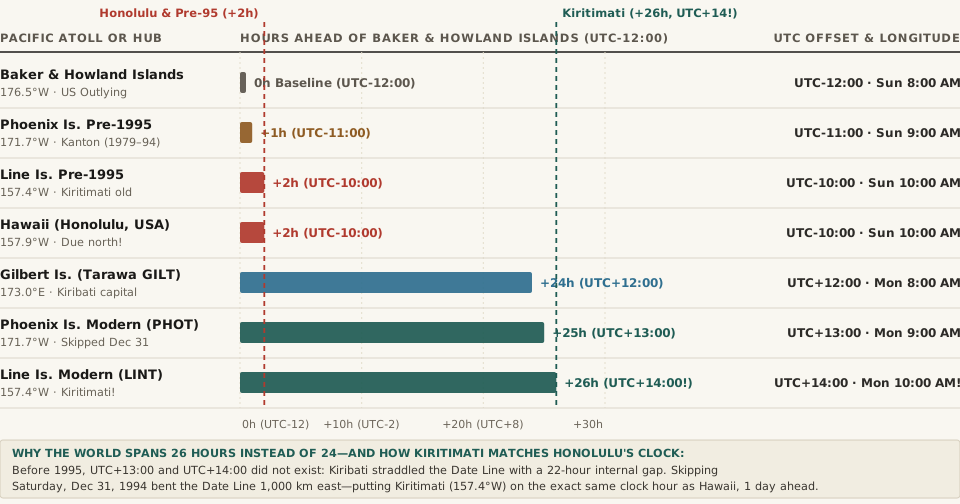
Chart comparing hours ahead of Baker and Howland Islands (UTC-12:00) across pre-1995 Phoenix and Line Islands, Honolulu Hawaii (UTC-10:00), Tarawa Gilbert Islands (UTC+12:00), modern Phoenix Islands (UTC+13:00), and modern Line Islands Kiritimati (UTC+14:00, +26 hours ahead)
Figure 1: Total hour offset ahead of UTC-12:00 across central Pacific atolls before and after Kiribati skipped Saturday, December 31, 1994 (Wikipedia — Time in Kiribati; Line Islands).

2. Skipping Saturday, December 31, 1994: The Birth of UTC+13:00 and UTC+14:00

To put every atoll in Kiribati on the same calendar day without changing the local solar clock time on any island, President Teburoro Tito's government enacted a bold solution at the end of 1994 (Time in Kiribati; International Date Line):

  1. Erasing New Year's Eve 1994: In the Phoenix and Line Islands, Saturday, December 31, 1994 was removed from the calendar entirely. After 11:59:59 PM on Friday, December 30, 1994, clocks advanced directly to 12:00:00 AM on Sunday, January 1, 1995.
  2. Inventing PHOT (UTC+13:00) and LINT (UTC+14:00): Instead of shifting the eastern islands backward to Tarawa's UTC+12:00 clock (which would have put solar noon at 2:00 PM in Kiritimati), Kiribati added exactly +24 hours to their existing offsets—turning the Phoenix Islands' UTC-11:00 into Phoenix Island Time (PHOT, UTC+13:00) and the Line Islands' UTC-10:00 into Line Islands Time (LINT, UTC+14:00).
  3. The Millennium Island Tourism Coup: By pushing the Date Line 1,000 kilometers (620 miles) east to wrap around Caroline Atoll (150°13'W, renamed Millennium Island) and inhabited Kiritimati, Kiribati became the first nation on Earth to greet the dawn of January 1, 2000.

"To solve it, the government of Kiribati introduced a change of date for its eastern half on 31 December 1994, from time zones UTC−11:00 and UTC−10:00 to UTC+13:00 and UTC+14:00. Before this, UTC+13:00 and UTC+14:00 did not exist."

3. The Honolulu–Kiritimati Longitude Twins & How Three Calendar Days Coexist

Look at a globe along the 157°W to 158°W meridian:

  • Honolulu, Hawaii (21°18'N, 157°51'W — Pacific/Honolulu): Operates on UTC-10:00.
  • Kiritimati, Kiribati (1°52'N, 157°24'W — Pacific/Kiritimati): Sits directly south of Honolulu at virtually the exact same longitude, operating on UTC+14:00.

Because +14 - (-10) = 24 hours, Honolulu and Kiritimati share the exact same wall-clock time to the minute—when it is 10:30 AM in Honolulu, it is 10:30 AM in Kiritimati—except Kiritimati is always one full calendar day ahead (Wikipedia — Line Islands). Even more remarkably, compare Kiritimati (UTC+14:00) against the U.S. Minor Outlying Islands of Baker Island and Howland Island (UTC-12:00) just north of the Equator at 176.5°W: every day between 10:00 UTC and 10:59 UTC, it is simultaneously 10:00 PM Yesterday (e.g., Saturday) on Baker Island (UTC-12:00), 10:00 AM Today (Sunday) in London (UTC+00:00), and 12:00 AM Tomorrow (Monday) in Kiritimati (UTC+14:00)—three consecutive calendar dates alive on Earth at the exact same instant!

4. Complete Data Table: Kiribati's Three Time Zones & The 26-Hour Global Span

The reproducible table below—matching the companion CSV (kiribati-utc-14-line-islands-1994-date-line-realignment-and-26-hour-span.csv)—lists the coordinates, IANA identifiers, and simultaneous timestamps across the 26-hour Pacific span:

Pacific Island Group or Hub IANA Identifier Longitude Official Offset Span vs. UTC-12:00 Simultaneous Time at 20:00 UTC Sunday Historical & Geopolitical Note
Baker & Howland Islands (US) Etc/GMT+12 176.48°W UTC-12:00 Baseline (0 hr) Sunday 8:00 AM Earliest clock zone on Earth; 26h behind Kiritimati
Phoenix Islands (Pre-1995) Pacific/Kanton (Old) 171.68°W UTC-11:00 +1 hr Sunday 9:00 AM Lagged 23h behind Tarawa capital until Dec 30, 1994
Line Islands (Pre-1995) Pacific/Kiritimati (Old) 157.40°W UTC-10:00 +2 hr Sunday 10:00 AM Lagged 22h behind Tarawa; skipped Sat, Dec 31, 1994
Hawaii (Honolulu, USA) Pacific/Honolulu 157.86°W UTC-10:00 +2 hr Sunday 10:00 AM Same longitude & clock time as Kiritimati, 1 day behind
Gilbert Islands (Tarawa — GILT) Pacific/Tarawa 173.00°E UTC+12:00 +24 hr Monday 8:00 AM Kiribati capital; anchored west of 180° since 1979
Phoenix Islands (Kanton — PHOT) Pacific/Kanton 171.68°W UTC+13:00 +25 hr Monday 9:00 AM Adopted UTC+13:00 on Jan 1, 1995 (No DST)
Line Islands (Kiritimati — LINT) Pacific/Kiritimati 157.40°W UTC+14:00 +26 hr! Monday 10:00 AM! Farthest-forward time zone on Earth; 24h ahead of Hawaii

To test how your schedules, flights, or software timestamps behave across UTC+14:00, UTC-10:00, and international date boundaries, Open Tempo in your browser and scrub across all 26 hours of global civil time.

023 / 56

Why Did Samoa Skip Friday, December 30, 2011—And Why Is American Samoa 24 Hours Behind Just 40 Miles Away?

Look up the calendar for the Independent State of Samoa in December 2011, and you will discover a missing day: Friday, December 30, 2011 never existed. When church bells and sirens rang across Apia at 11:59:59 PM on Thursday, December 29, 2011, clocks did not advance to Friday morning—they leaped 24 hours forward to 12:00:00 AM on Saturday, December 31, 2011. As documented in the historical registries of Time in Samoa, Daylight Saving Time in Samoa, the International Date Line, and contemporary reporting by The Guardian and CBC News, Samoa (joined by the New Zealand territory of Tokelau) redrew the International Date Line from 84 kilometers west of its shores to 40 kilometers east of its shores—splitting the Samoan archipelago into two time zones separated by 24 hours across a 40-mile strait.

Why did Samoa switch sides of the International Date Line twice in 119 years—first by celebrating July 4, 1892 twice, and then by erasing December 30, 2011—and how can you celebrate your birthday twice on a 25-minute twin-prop flight between Apia and Pago Pago? Here is the complete geopolitical and timekeeping story.

1. The 1892 Double Fourth of July: Why Samoa Was on the American Side in the First Place

Geographically, the entire Samoan archipelago sits near longitude 171°W to 172°W—roughly 8 degrees east of the 180° antimeridian. Before 1892, European mariners and missionaries who reached Samoa from the west kept Asian/Australasian calendar dates (four hours ahead of Japan, on the west side of the Date Line).

However, as recorded in Wikipedia's International Date Line history, late-19th-century American trading houses operating steamships out of San Francisco persuaded King Mālietoa Laupepa that Samoa should align its calendar with California (three hours behind Pacific Standard Time). To move from the Asian side of the Date Line to the American side (UTC-11:00), Samoa had to repeat a calendar day—and it chose Monday, July 4, 1892, American Independence Day, giving 1892 two consecutive Fourths of July and a 367-day calendar year.

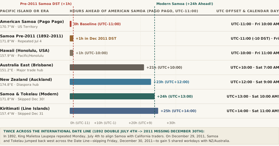
Chart comparing hours ahead of American Samoa (Pago Pago, UTC-11:00) across pre-2011 Samoa, Hawaii (UTC-10:00), Australia East (UTC+10:00), New Zealand (UTC+12:00), modern Samoa & Tokelau (UTC+13:00, +24 hours ahead), and Kiritimati (UTC+14:00, +25 hours ahead)
Figure 1: Hours ahead of American Samoa (UTC-11:00) across Pacific hubs before and after Samoa and Tokelau skipped Friday, December 30, 2011 (Wikipedia — Time in Samoa; International Date Line).

2. The Three-Day Business Week Problem: Why Prime Minister Tuilaepa Erased December 30, 2011

Over the next 119 years, Samoa's economic gravity shifted completely away from California toward New Zealand (UTC+12:00 / UTC+13:00 NZDT), Australia (UTC+10:00 / UTC+11:00 AEDT), and East Asia. By 2011, sitting on UTC-11:00 created an expensive scheduling trap documented by The Guardian and Time in Samoa:

  • Losing Two Workdays Every Single Week: Because Samoa was 21 to 23 hours behind Sydney and Auckland, when it was Friday in Apia, banks and port authorities in Auckland and Sydney were already closed for Saturday. Conversely, when New Zealand businesses opened on Monday morning, it was still Sunday morning in Samoa. Instead of a five-day international workweek, Samoan exporters and families had only three full overlapping business days per week (Tuesday, Wednesday, and Thursday in NZ/Australia corresponding to Monday, Tuesday, and Wednesday in Samoa).
  • The Statutory Jump at Midnight on December 29, 2011: Under the International Date Line Act 2011 spearheaded by Prime Minister Tuilaepa Sailele Malielegaoi, Samoa jumped 24 hours forward at the end of Thursday, December 29, 2011—moving its standard time from UTC-11:00 to UTC+13:00 (and its summer Daylight Saving Time, observed from 2010 until its permanent abolition in 2021, from UTC-10:00 to UTC+14:00).
  • Paid Missing Friday & Tokelau's Simultaneous Leap: As noted in Daylight Saving Time in Samoa, all employees scheduled to work on the nonexistent Friday, December 30, 2011 were guaranteed a full day's wage by law, while roughly 500 Samoan citizens born on December 30 skipped their 2011 birthday. Because the New Zealand territory of Tokelau (Pacific/Fakaofo) relies on Apia for transport and administration, Tokelau skipped December 30, 2011 right alongside Samoa, shifting from UTC-11:00 to UTC+13:00 year-round (UTC+13:00 registry).

"At the end of Thursday, 29 December 2011, Samoa continued directly to Saturday, 31 December 2011, skipping the entire calendar day of Friday, 30 December 2011 and effectively redrawing the International Date Line."

3. The 40-Mile, 24-Hour Paradox Between Samoa and American Samoa

While independent Samoa (Pacific/Apia) jumped to the west side of the Date Line, neighboring American Samoa (Pacific/Pago_Pago)—an unincorporated territory of the United States located just 40 miles (64 km) across the ocean at its closest island point (and ~77 miles airport-to-airport from Faleolo APW to Pago Pago PPG)—remained on the American side at UTC-11:00 (UTC-11:00).

Since Samoa ended seasonal Daylight Saving Time in 2021 and locked its clocks permanently at UTC+13:00, the two neighbors exhibit one of the most mind-bending relationships in global travel:

  • Identical Wall-Clock Time, One Full Day Apart: Because +13 - (-11) = +24 hours, the minute and hour hands on wall clocks in Apia and Pago Pago show the exact same time of day all year round—when it is 10:15 AM in Apia, it is 10:15 AM in Pago Pago—except Apia is on Saturday while Pago Pago is still on Friday!
  • Time-Travel Aviation in 25 Minutes: Board a 25-minute inter-island flight from Apia (APW) at 12:00 PM Saturday, and you touch down in Pago Pago (PPG) at 12:25 PM Friday—23 hours and 35 minutes before you took off, allowing travelers to celebrate New Year's Eve or a birthday twice within a single hour of flying.

4. Complete Data Table: Samoa, American Samoa & Pacific Date Line Zones

The reproducible table below—matching the companion CSV (samoa-december-30-2011-date-line-jump-and-pacific-24-hour-time-gaps.csv)—compares the UTC offsets, longitudes, and calendar relationships across the central Pacific Date Line corridor:

Pacific Territory or Era IANA tzdb Zone Longitude Standard Offset Gap vs. American Samoa Local Time When Pago Pago Is Fri 10:00 AM Date Line & Trade Alignment Note
American Samoa (Pago Pago) Pacific/Pago_Pago 170.70°W UTC-11:00 (No DST) Baseline (0 hr) Friday 10:00 AM US territory; stayed east of the Date Line
Samoa Pre-2011 (1892–2011) Pacific/Apia (Historical) 171.76°W UTC-11:00 (-10 DST) 0 hr (+1 hr in DST) Friday 10:00 AM (11:00 AM DST) Repeated Monday, July 4, 1892 for US trade
Hawaii (Honolulu) Pacific/Honolulu 157.86°W UTC-10:00 (No DST) 1 hr ahead Friday 11:00 AM 23 hours behind modern Apia
Australia East (Brisbane / Sydney) Australia/Brisbane 151.21°E UTC+10:00 (+11 AEDT) 21 hr ahead (22h DST) Saturday 7:00 AM (8:00 AM AEDT) Only 3 shared workdays/week with pre-2011 Samoa
New Zealand (Auckland) Pacific/Auckland 174.76°E UTC+12:00 (+13 NZDT) 23 hr ahead (24h DST) Saturday 9:00 AM (10:00 AM NZDT) Primary Samoan trade & expat hub
Samoa & Tokelau (Modern) Pacific/Apia · Pacific/Fakaofo 171.76°W UTC+13:00 (No DST) 24 hr ahead! Saturday 10:00 AM! Skipped Friday, Dec 30, 2011; abolished DST in 2021
Kiribati Line Islands (Kiritimati) Pacific/Kiritimati 157.40°W UTC+14:00 (No DST) 25 hr ahead! Saturday 11:00 AM! Skipped Dec 31, 1994; 25 hours ahead of Pago Pago

When you are planning flights or remote meetings across the International Date Line between Honolulu (UTC-10), Pago Pago (UTC-11), Apia (UTC+13), and Auckland (UTC+12/+13), Open Tempo in your browser to see exact calendar-day boundaries side by side.

024 / 56

Why Does Australia Split Into Five Time Zones in Summer—With Adelaide 30 Minutes Ahead of Brisbane?

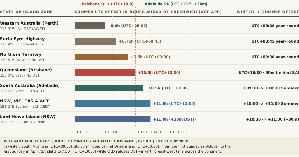
Look at a map of Australia in July—the middle of the Southern Hemisphere winter—and the country's time zones look relatively orderly: Western Australia sits on UTC+08:00 (AWST), the Northern Territory and South Australia share a half-hour offset at UTC+09:30 (ACST), and the entire eastern seaboard from Cairns and Brisbane down to Sydney, Melbourne, Canberra, and Hobart shares UTC+10:00 (AEST). Then arrives 2:00 AM on the first Sunday in October. Because Australian timekeeping is legislated individually by each state and territory under Section 51 of the Australian Constitution, five southern and southeastern jurisdictions spring forward for Daylight Saving Time while three northern and western jurisdictions refuse to touch their clocks. Overnight, as documented in Wikipedia's Time in Australia reference, Daylight Saving Time in Australia, Time and Date's Australian registry, and the Reserve Bank of Australia's official Daylight Saving schedule, continental Australia fractures from three standard time zones into five summer time zones—creating a six-month window where Adelaide runs 30 minutes ahead of Brisbane despite sitting 1,400 kilometers further west.

Why did South Australia and the Northern Territory adopt a 30-minute offset in the 1890s, why do Queensland, Western Australia, and the Northern Territory reject Daylight Saving Time, and why does NSW's Lord Howe Island shift its clocks by only 30 minutes every October? Here is the complete geographic and IANA tzdb breakdown.

1. How Three Winter Zones Fracture Into Five Summer Zones Every October

Since 2008—when New South Wales, Victoria, Tasmania, South Australia, and the Australian Capital Territory harmonized their transition dates following a 12 April 2007 intergovernmental agreement—Australian Daylight Saving Time begins at 02:00 local standard time on the first Sunday in October and ends at 03:00 local daylight time on the first Sunday in April (for example, ending Sunday, 5 April 2026 and starting Sunday, 4 October 2026, per the Reserve Bank of Australia).

Because the tropical and western states opt out, the continent splits along both latitude and longitude lines simultaneously:

  • UTC+08:00 — Australian Western Standard Time (AWST, Australia/Perth): Covers all of Western Australia. Western Australia held a three-year DST trial from 2006 to 2009 and rejected permanent adoption in a May 2009 referendum (the fourth time WA voters rejected DST since 1975). In summer, Perth falls a full 3 hours behind Sydney and Melbourne.
  • UTC+09:30 — Australian Central Standard Time (ACST, Australia/Darwin): Covers the Northern Territory year-round. Because Darwin sits in the tropics at 12.46°S where daylight length barely varies between winter and summer, the Northern Territory stays on UTC+09:30 all year.
  • UTC+10:00 — Australian Eastern Standard Time (AEST, Australia/Brisbane): Covers Queensland year-round after Queenslanders voted down DST in a 1992 referendum (driven by rural and northern Queensland voters opposing late summer sunrises and evening heat).
  • UTC+10:30 — Australian Central Daylight Time (ACDT, Australia/Adelaide & Australia/Broken_Hill): South Australia (plus the far-western New South Wales mining city of Broken Hill) advances one hour from UTC+09:30 to UTC+10:30.
  • UTC+11:00 — Australian Eastern Daylight Time (AEDT, Australia/Sydney, Australia/Melbourne, Australia/Hobart, Australia/Canberra): New South Wales, Victoria, Tasmania, Jervis Bay Territory, and the ACT advance one hour from UTC+10:00 to UTC+11:00.
Chart comparing summer UTC offsets across Australian states and islands from October to April: Perth UTC+08:00, Eucla UTC+08:45, Darwin UTC+09:30, Brisbane UTC+10:00, Adelaide UTC+10:30, Sydney/Melbourne UTC+11:00, and Lord Howe Island UTC+11:00
Figure 1: Active summer UTC offsets across Australian jurisdictions from the first Sunday in October to the first Sunday in April (Wikipedia — Time in Australia; Reserve Bank of Australia).

2. The Adelaide–Brisbane Paradox: When West Beats East by 30 Minutes

Normally, because Earth rotates from west to east, moving eastward always advances local clock time. Look at the coordinates of Adelaide and Brisbane:

  • Adelaide, South Australia: Longitude 138°36'E (138.60°E).
  • Brisbane, Queensland: Longitude 153°02'E (153.03°E)—sitting 14.43° of longitude (nearly one full 15° solar hour, or ~1,400 km) east of Adelaide.

During the Southern Hemisphere winter (April to October), geography behaves normally: Brisbane (UTC+10:00) is 30 minutes ahead of Adelaide (UTC+09:30). However, from October to April, South Australia springs forward to ACDT (UTC+10:30) while Queensland stays frozen at AEST (UTC+10:00). For six months of every year, when it is 12:00 PM noon in Brisbane on the Pacific coast, it is already 12:30 PM in Adelaide 1,400 kilometers to the west!

"During the usual periods of DST, the three standard time zones in Australia become five zones. This includes the areas that do not observe DST: Western Australia (UTC+08:00), the Northern Territory (UTC+09:30), and Queensland (UTC+10:00)."

3. Three More Australian Anomalies: Lord Howe's 30-Minute Shift, Broken Hill, and Coolangatta–Tweed Heads

Beyond the five major state zones, Time and Date's audit of Australia's 9 total time zones and Wikipedia's civil legislation history document three remarkable local edge cases:

  1. Lord Howe Island's Unique 30-Minute DST Shift (UTC+10:30 → UTC+11:00): Located 600 km east of Port Macquarie in the Tasman Sea, Lord Howe Island (part of New South Wales, Australia/Lord_Howe) operates on Lord Howe Standard Time (LHST, UTC+10:30) during winter. In summer, instead of advancing by 60 minutes like the rest of the world, Lord Howe Island advances its clocks by only 30 minutes to Lord Howe Daylight Time (LHDT, UTC+11:00) so it matches Sydney time during summer tourist season. It is the only jurisdiction on Earth with a 30-minute Daylight Saving shift.
  2. Broken Hill, NSW (Australia/Broken_Hill): Although the silver-mining city of Broken Hill lies inside the state borders of New South Wales, it sits near the South Australian border at 141.45°E and historically linked by rail to Adelaide rather than Sydney. Broken Hill therefore observes South Australian time (ACST UTC+09:30 in winter and ACDT UTC+10:30 in summer)—the only town in NSW outside AEST/AEDT.
  3. The Twin-Town New Year's Eve Border (Coolangatta, QLD vs. Tweed Heads, NSW): On the Gold Coast border, Boundary Street divides Coolangatta (Queensland, UTC+10:00) from Tweed Heads (New South Wales, UTC+11:00 in summer). Every December 31, residents celebrate New Year's Eve at midnight in Tweed Heads, walk across the street into Coolangatta, and celebrate New Year's Eve a second time one hour later.

4. Complete Data Table: Australia's Winter vs. Summer Time Zones

The reproducible dataset below—bundled in the downloadable CSV (australia-five-summer-time-zones-awst-acst-aest-acdt-aedt-and-lord-howe.csv)—lists every mainland state, territory, and special island zone across winter and summer:

State, Territory or Region IANA tzdb Zone Hub Longitude Winter Standard (Apr–Oct) Summer Offset (Oct–Apr) DST Shift Summer Gap vs. Sydney (UTC+11)
Western Australia (Perth) Australia/Perth 115.86°E AWST (UTC+08:00) AWST (UTC+08:00) 0 min (No DST) 3 hr 00 min behind Sydney
Eucla / Eyre Highway Australia/Eucla 128.88°E ACWST (UTC+08:45) ACWST (UTC+08:45) 0 min (Unofficial) 2 hr 15 min behind Sydney
Northern Territory (Darwin) Australia/Darwin 130.84°E ACST (UTC+09:30) ACST (UTC+09:30) 0 min (No DST) 1 hr 30 min behind Sydney
Queensland (Brisbane) Australia/Brisbane 153.03°E AEST (UTC+10:00) AEST (UTC+10:00) 0 min (No DST) 1 hr 00 min behind Sydney (30m behind SA!)
South Australia & Broken Hill Australia/Adelaide 138.60°E ACST (UTC+09:30) ACDT (UTC+10:30) +60 min DST 30 min behind Sydney (30m ahead of QLD!)
NSW, VIC, TAS & ACT Australia/Sydney 151.21°E AEST (UTC+10:00) AEDT (UTC+11:00) +60 min DST Baseline (0 min)
Lord Howe Island (NSW) Australia/Lord_Howe 159.08°E LHST (UTC+10:30) LHDT (UTC+11:00) +30 min DST! Matches Sydney in summer (UTC+11:00)

When you are scheduling calls across Sydney (AEDT), Brisbane (AEST), Adelaide (ACDT), Perth (AWST), and US or European offices between October and April, Open Tempo in your browser to compare all five Australian summer zones on a single live timeline.