YellowSquared  /  Field notes

Notes from the workshop

56 posts, newest first. Choose an app to narrow the feed.

041 / 56

Why Does Newfoundland Have a 30-Minute Time Zone Offset? How St. John's Uses UTC-3:30 in Winter and UTC-2:30 in Summer

Anyone who grew up watching the Canadian Broadcasting Corporation (CBC) can recite the network’s most famous scheduling tagline by heart: “This program airs at 8:00 PM Eastern—8:30 in Newfoundland.” Across the entire Western Hemisphere, from Alaska and California down to Chile and Argentina, every active civil time zone is offset from Coordinated Universal Time (UTC) by a whole number of hours—with one solitary exception: the Canadian island of Newfoundland and southeastern Labrador observe the Newfoundland Time Zone, sitting at UTC-03:30 (Newfoundland Standard Time, NST) in winter and UTC-02:30 (Newfoundland Daylight Time, NDT) in summer.

When you coordinate cross-Canada or transatlantic calls in Tempo, Newfoundland’s 30-minute offset creates a 90-minute gap ahead of New York and Toronto (America/Toronto) and a 30-minute gap ahead of Halifax (America/Halifax)—while placing three distinct time zones within 15 miles of water in the Gulf of St. Lawrence.

The 52°30′W Signal Hill Meridian: Why St. John’s Splits the Hour in Half

Why didn’t Newfoundland simply join Atlantic Standard Time (UTC-04:00) alongside Nova Scotia, New Brunswick, and Prince Edward Island? The answer combines exact solar longitude math with pre-1949 sovereignty:

  • Dead-Center on the 52°30'W Half-Meridian: Standard global 1-hour time zones sit every 15 degrees of longitude (60°W = UTC-04:00, 45°W = UTC-03:00). The halfway line between 60°W and 45°W is 52°30'W (52.50°W). Multiplying 52.50° × 4 solar minutes per degree yields exactly 210.0 minutes = 3 hours and 30 minutes behind Greenwich (UTC-03:30).
  • St. John’s Astronomical Fit (52°43'W): Newfoundland’s capital and largest port, St. John’s (52.71°W), sits just 0.21 degrees (13 arcminutes) west of the 52°30'W meridian—meaning true mean solar noon in St. John’s occurs within 50 seconds of 12:00 PM NST.
  • An Independent Dominion Until March 31, 1949 (Time in Canada): When Sir Sandford Fleming proposed global standard time zones in the 1880s, Newfoundland was a separate self-governing British colony (and later the Dominion of Newfoundland), not a province of Canada. In 1884, St. John’s anchored its official time to the noon cannon on Signal Hill (UTC-03:30:52), and in 1935 the Newfoundland Standard Time Act rounded the legal offset to UTC-03:30. When Newfoundland confederated with Canada in 1949, it retained its sovereign time zone.
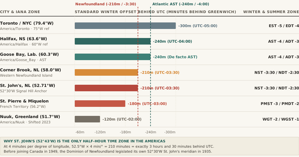
Chart comparing standard winter UTC offsets in minutes behind Greenwich across Toronto, Halifax, Goose Bay, Corner Brook, St. John's, St. Pierre and Miquelon, and Nuuk
Figure 1: Standard winter offset behind UTC (in minutes) across eastern Canada, French St. Pierre & Miquelon, and Greenland. Download the complete meridian comparison table in newfoundland-time-zone-utc-3-30-solar-meridian-comparison.csv.

How Eastern Canada’s Neighboring Time Zones Compare

Although the provincial statute (Standard Time Act, RSNL 1990) technically defines Newfoundland Time (UTC-03:30 / UTC-02:30) for the entire province of Newfoundland and Labrador, practical geography divides the region—and its immediate offshore neighbors—into four different clocks:

City / Jurisdiction IANA Time Zone Longitude Reference Meridian Winter Standard Summer Daylight Winter Mean Solar Noon
Toronto / New York America/Toronto 79.38°W 75.0°W EST (UTC-05:00) EDT (UTC-04:00) 12:18 PM EST
Halifax, Nova Scotia America/Halifax 63.57°W 60.0°W AST (UTC-04:00) ADT (UTC-03:00) 12:14 PM AST
Happy Valley-Goose Bay, Lab. America/Goose_Bay 60.33°W 60.0°W AST (UTC-04:00) ADT (UTC-03:00) 12:01 PM AST
Corner Brook, Western NL America/St_Johns 57.95°W 52.5°W NST (UTC-03:30) NDT (UTC-02:30) 12:22 PM NST
St. John’s, Newfoundland America/St_Johns 52.71°W 52.5°W NST (UTC-03:30) NDT (UTC-02:30) 12:01 PM NST
St. Pierre & Miquelon (France) America/Miquelon 56.18°W 45.0°W PMST (UTC-03:00) PMDT (UTC-02:00) 12:45 PM PMST
Nuuk, Greenland (Post-2023) America/Nuuk 51.72°W 30.0°W WGT (UTC-02:00) WGST (UTC-01:00) 1:27 PM WGT

“Take the 90-minute passenger ferry from Fortune, Newfoundland (55.8°W, on UTC-3:30) to the French territory of Saint-Pierre and Miquelon (56.2°W, on UTC-3:00): you travel slightly west, yet your watch jumps forward by 30 minutes.”

Three Quirks of Newfoundland Time Every Traveler and Developer Should Know

  1. The Labrador Split (America/St_Johns vs. America/Goose_Bay): Only the southeastern coast of Labrador (from L’Anse-au-Clair to Black Tickle, closest to the Strait of Belle Isle) actually uses Newfoundland Time (UTC-03:30). The rest of mainland Labrador—including Happy Valley-Goose Bay (60.3°W) and Labrador City—sits right on the 60°W meridian and observes Atlantic Time (UTC-04:00 / UTC-03:00) in practice.
  2. The 1988 “Double Daylight Saving Time” Experiment (UTC-01:30): Between April 3 and October 30, 1988, the provincial government advanced clocks by 2 full hours instead of 1 hour for summer—placing Newfoundland on UTC-01:30. When midsummer sunset moved past 10:00 PM and autumn schoolchildren had to wait for buses in pitch-black morning darkness until after 8:30 AM, public backlash ended the experiment after a single season.
  3. New Year’s Eve Arrives First in North America by 30 Minutes: Because America/St_Johns (UTC-03:30) sits 30 minutes ahead of Atlantic Standard Time (UTC-04:00) and 90 minutes ahead of Eastern Standard Time (UTC-05:00), Newfoundland rings in the New Year at 10:30 PM New York/Toronto time.

Planning meetings or broadcasts across St. John’s (UTC-03:30), Halifax (UTC-04:00), Toronto (UTC-05:00), and London? Open Tempo in your browser to compare half-hour and whole-hour overlaps effortlessly, or explore our time-zone engineering guides.
042 / 56

Why Are Indiana and Kentucky Split Between Eastern and Central Time?

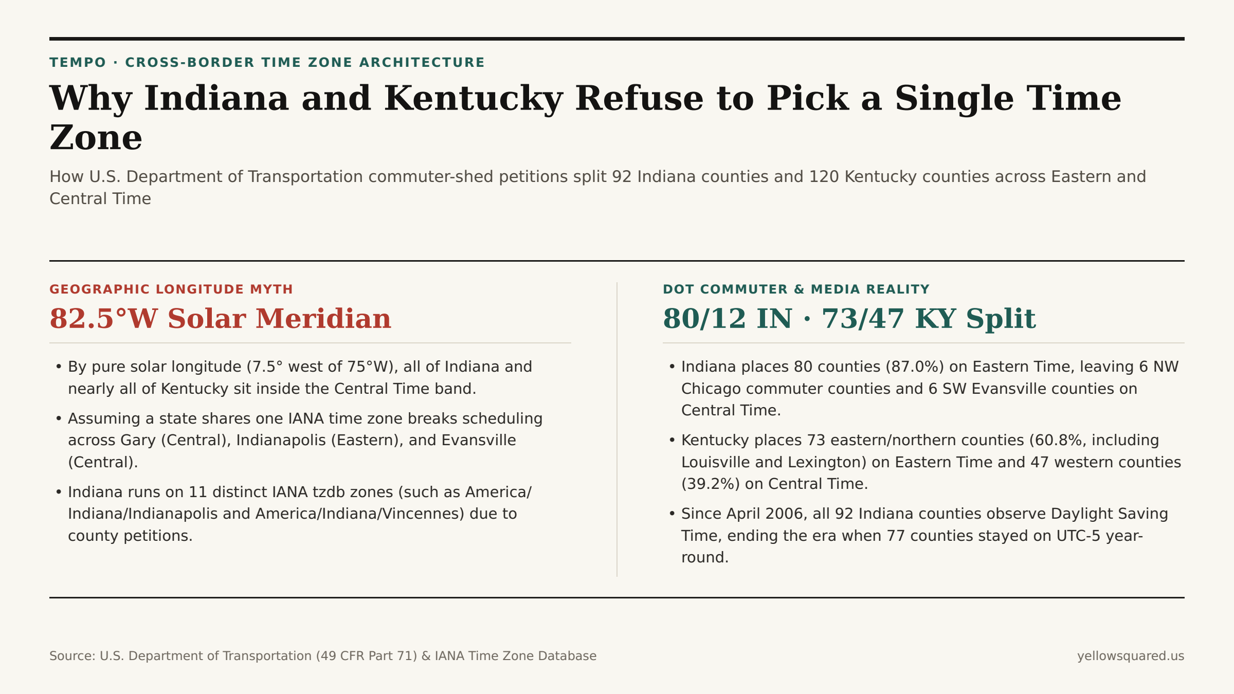
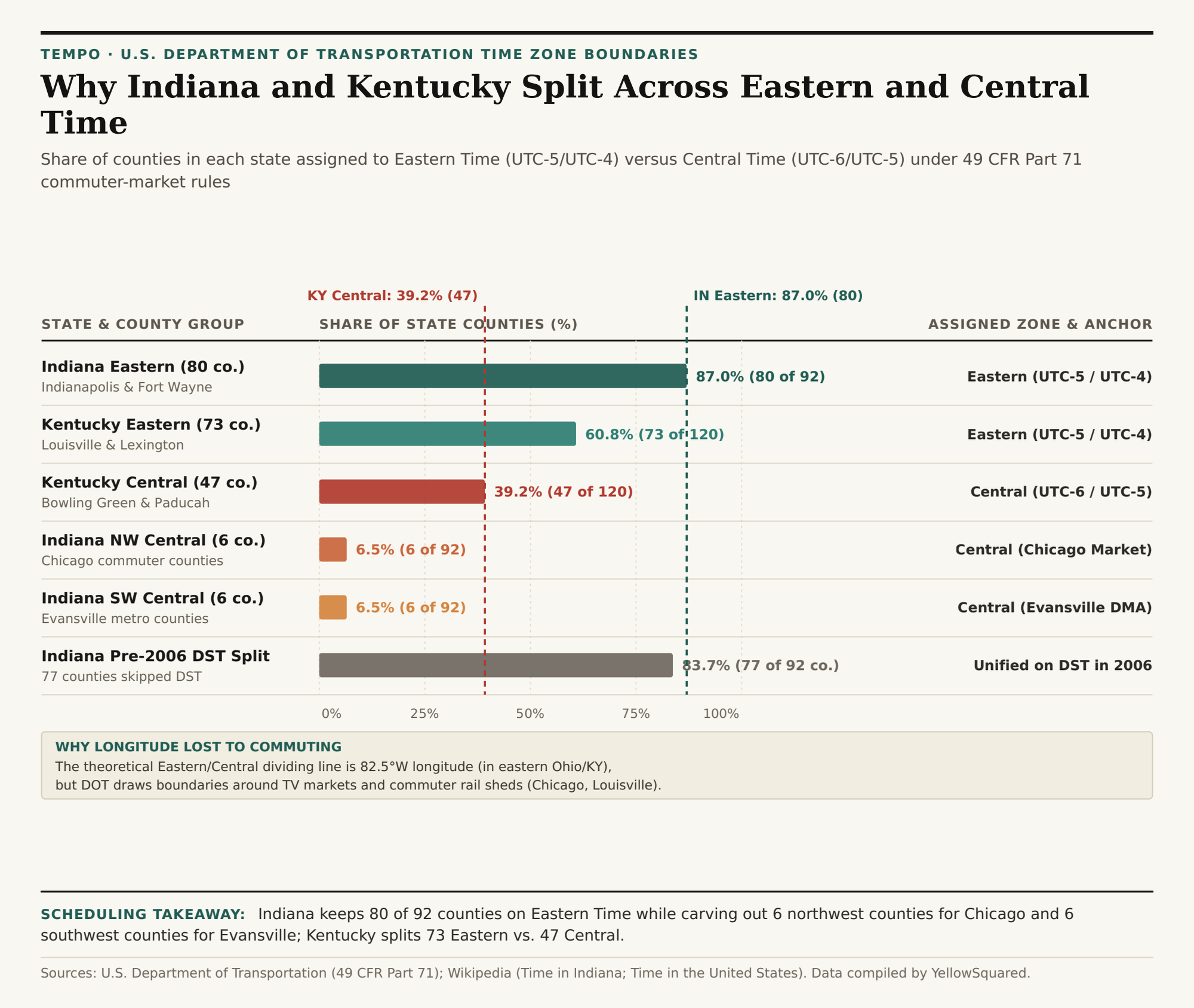
Drive ninety minutes southeast from downtown Chicago into Indiana, or two hours west from Louisville across Kentucky, and your phone clock will jump back a full hour without crossing a state line. Under U.S. Department of Transportation (DOT) time zone regulations (49 CFR Part 71), 80 of Indiana's 92 counties (87.0%) observe Eastern Time while 12 counties (13.0%) observe Central Time, and 73 of Kentucky's 120 counties (60.8%) observe Eastern Time while 47 western counties (39.2%) remain on Central Time.

If time zones followed pure solar geometry, neither state would be in Eastern Time at all. Because Earth rotates 15 degrees of longitude per hour, Eastern Standard Time (UTC-5) is centered on the 75th meridian west (near Philadelphia), making the theoretical boundary with Central Standard Time (UTC-6, centered on 90°W) the 82.5°W meridian — a line that runs through eastern Ohio and clips only the easternmost tip of Pike County, Kentucky. Every square mile of Indiana (which lies between 84°47'W and 88°06'W) sits geographically inside the solar Central Time band. Yet over the past century, federal commerce statutes traded longitudinal symmetry for metropolitan commuter and television market cohesion. To see how county-level time boundaries affect cross-state meetings right now, Open Tempo in your browser and compare live IANA zone offsets side by side.

Comparison of the 82.5 degree West geographic meridian versus U.S. Department of Transportation county-level Eastern and Central time zone splits in Indiana and Kentucky
While the 82.5°W solar meridian places all of Indiana and nearly all of Kentucky in the Central Time band, U.S. Department of Transportation rules keep 87.0% of Indiana counties and 60.8% of Kentucky counties on Eastern Time.

How Commuter Rail and Broadcast Markets Redrew the Map

When Congress passed the Standard Time Act of 1918 and later transferred regulatory authority from the Interstate Commerce Commission to the U.S. Department of Transportation via the Uniform Time Act of 1966, it established a single statutory criterion for moving a county between time zones: the convenience of commerce. When county commissioners petition the DOT for a time zone reassignment, federal examiners do not measure solar noon; instead, they audit where residents commute to work, where hospitals and wholesale suppliers are located, and which Designated Market Area (DMA) supplies local television news and school-closing broadcasts.

As documented in the historical record of Time in Indiana, this commerce test created a three-way geographic split across Indiana's 92 counties:

  • The 80 Eastern Time Counties (UTC-5 / EDT UTC-4): Stretching from Indianapolis and Fort Wayne to South Bend and the Louisville metro counties (Clark, Floyd, and Harrison), 87.0% of Indiana's counties align their clocks with Ohio, Michigan, and East Coast financial markets.
  • The 6 Northwest Central Time Counties (UTC-6 / CDT UTC-5): Lake, Porter, LaPorte, Newton, Jasper, and Starke counties form the Indiana commuter belt of metropolitan Chicago (Gary, Hammond, Crown Point, Michigan City). Because tens of thousands of Northwest Indiana residents ride the South Shore Line commuter rail into Chicago daily and watch Chicago network television, keeping those six counties on Central Time prevents a one-hour border jump across the Illinois state line.
  • The 6 Southwest Central Time Counties (UTC-6 / CDT UTC-5): Vanderburgh, Posey, Warrick, Gibson, Spencer, and Perry counties anchor the Evansville tri-state metro area (Evansville, Boonville, Mount Vernon, Princeton, Tell City), whose labor shed and television broadcast footprint interlock directly with southern Illinois and western Kentucky (Henderson and Daviess counties), both of which operate on Central Time.
Horizontal bar chart showing the percentage of counties in Indiana and Kentucky assigned to Eastern Time versus Central Time
County-by-county time zone distribution across Indiana (92 counties) and Kentucky (120 counties), highlighting the 2006 statewide Daylight Saving Time unification in Indiana. Download the full county dataset (CSV).

How Solar Time Differs Across Indiana

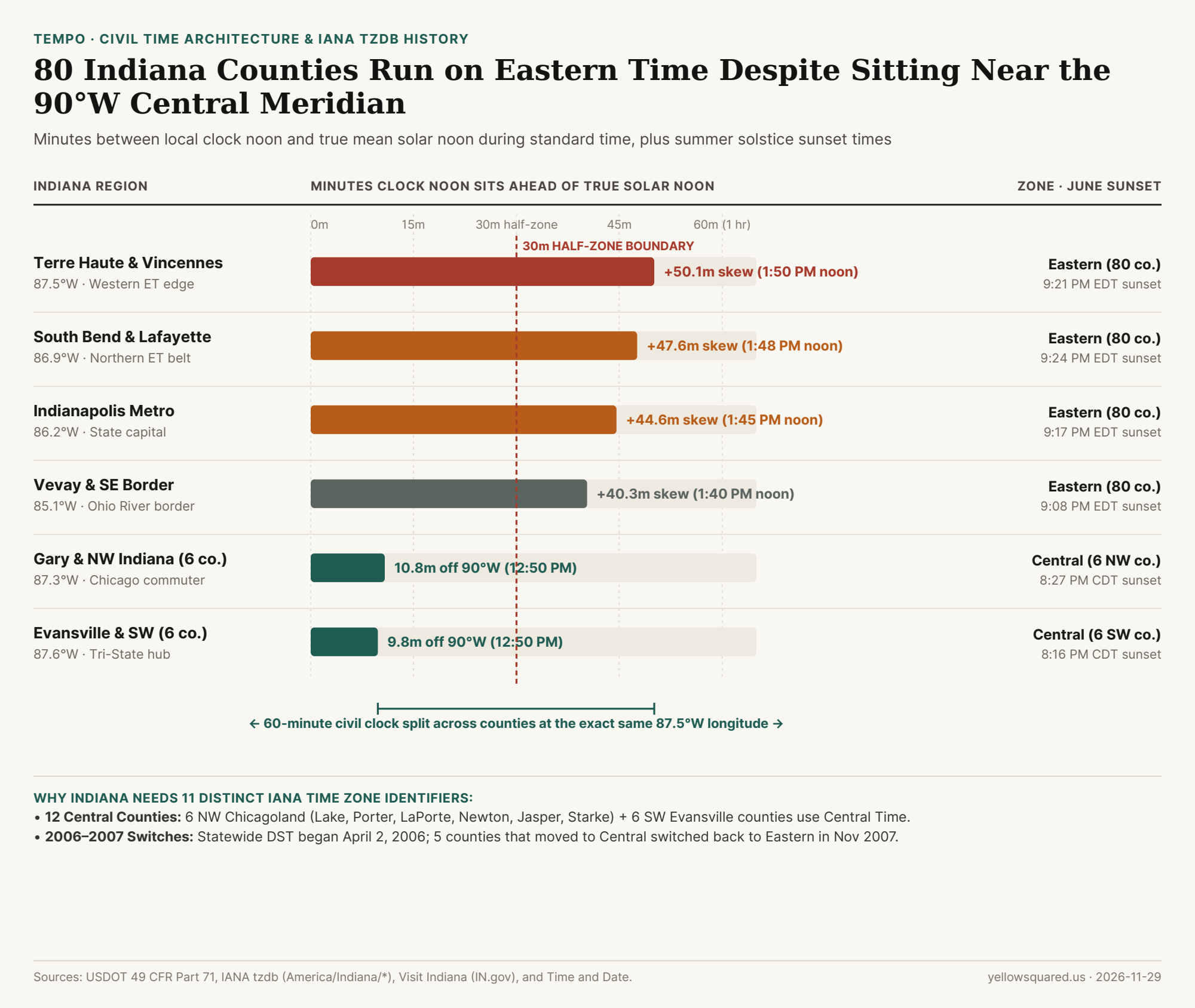
Indiana's territory spans 84°47'W on the Ohio border to 88°06'W at the Wabash River confluence. Each degree of longitude shifts solar noon by about 4 minutes, so the Eastern counties lag the 75°W meridian by up to 50 minutes. Indianapolis (86.16°W) sits 44.6 minutes behind that meridian. In Terre Haute (87.41°W) and Vincennes (87.53°W), the lag reaches +50.1 minutes against standard time and +110.1 minutes under EDT, which is why summer solar noon there falls near 1:50 PM EDT.

Chart showing Indiana's 80 Eastern Time counties and 12 Central Time counties alongside solar noon skew and June solstice sunset times
Despite sitting between 84.8°W and 88.1°W, directly inside the geographic band of the 90°W Central meridian, 80 of Indiana's 92 counties observe Eastern Time, shifting summer solar noon to nearly 1:50 PM EDT along the Wabash River. Data: Download CSV dataset.
Indiana City / Region IANA Time Zone Longitude Summer Solstice Solar Noon Solar Skew vs. Meridian
Indianapolis (Eastern counties) America/Indiana/Indianapolis 86.16°W 1:45 PM EDT +44.6 min behind 75°W
South Bend & Lafayette America/Indiana/Indianapolis 86.25°W–86.89°W 1:48 PM EDT +47.6 min behind 75°W
Vincennes & Terre Haute America/Indiana/Vincennes 87.41°W–87.53°W 1:50 PM EDT +50.1 min behind 75°W
Starke County (Knox) America/Indiana/Knox 86.62°W 12:46 PM CDT -13.5 min ahead of 90°W
NW Indiana (Gary & Hammond, 6 counties) America/Chicago 87.00°W–87.52°W 12:50 PM CDT -10.0 min ahead of 90°W
SW Indiana (Evansville metro, 6 counties) America/Chicago 86.60°W–87.95°W 12:51 PM CDT -9.8 min ahead of 90°W

Why Indiana Has 11 Distinct IANA Time Zone Identifiers

For software engineers and distributed scheduling systems, Indiana is famous for occupying 11 separate America/Indiana/* and America/* entries inside the IANA Time Zone Database (tzdb). Before April 2006, 77 of Indiana's 80 Eastern Time counties refused to observe Daylight Saving Time, remaining locked on Eastern Standard Time (UTC-5) all year — which meant Indianapolis matched New York in winter and Chicago in summer. Meanwhile, five southeastern counties near Cincinnati and Louisville (Clark, Dearborn, Floyd, Harrison, and Ohio) observed Eastern Daylight Time unofficially to stay aligned with cross-river employers.

"Because historical timestamps before 2007 depend on which exact Indiana county recorded the event, the IANA database preserves separate zone files for Vincennes, Petersburg, Tell City, Knox, Winamac, Marengo, Vevay, and Indianapolis."

In Kentucky, the boundary runs diagonally from Breckinridge and Grayson counties near the Ohio River down to Wayne and McCreary counties on the Tennessee border. The 73 Eastern Time counties (60.8%) encompass Kentucky's "Golden Triangle" of Louisville, Lexington, and Northern Kentucky (across the river from Cincinnati), while the 47 Central Time counties (39.2%) cover Bowling Green, Owensboro, Hopkinsville, and Paducah, aligning western Kentucky with Nashville, Tennessee (America/Chicago).

Region / County Group State Counties State Share Observed Time Zone Primary Commuter / TV Market Anchor
Indiana Eastern Counties Indiana 80 of 92 87.0% Eastern (UTC-5 / UTC-4) Indianapolis, Fort Wayne, South Bend & Louisville
Indiana NW Central Counties Indiana 6 of 92 6.5% Central (UTC-6 / UTC-5) Chicago Metro (Lake, Porter, LaPorte, Newton, Jasper, Starke)
Indiana SW Central Counties Indiana 6 of 92 6.5% Central (UTC-6 / UTC-5) Evansville Tri-State (Vanderburgh, Posey, Warrick, Gibson, Spencer, Perry)
Kentucky Eastern Counties Kentucky 73 of 120 60.8% Eastern (UTC-5 / UTC-4) Louisville, Lexington & Northern Kentucky (Cincinnati Metro)
Kentucky Western Counties Kentucky 47 of 120 39.2% Central (UTC-6 / UTC-5) Bowling Green, Owensboro, Paducah & Nashville Commuter Belt

Why Did Indiana Adopt Statewide DST in 2006?

In 2005 the Indiana General Assembly passed statewide Daylight Saving Time effective April 2, 2006. The USDOT granted petitions for eight counties (Starke, Pulaski, Daviess, Dubois, Knox, Martin, Perry, and Pike) to move from Eastern to Central Time on the same day. Within 18 months, commuter and hospital scheduling complaints in southwestern Indiana led five of those counties (Daviess, Dubois, Knox, Martin, and Pike) to petition the USDOT to return to Eastern Time effective November 4, 2007, followed by Pulaski County. Because the IANA tz database creates a separate zone rule whenever a region's post-1970 clock history diverges, these shifts are why Indiana keeps its own America/Indiana/* files.

Practical Rules for Cross-Border Logistics and Remote Teams

Whenever you coordinate freight windows along Interstate 65 (which crosses from Central Time in Gary, Indiana, to Eastern Time near Lafayette, stays in Eastern Time through Indianapolis and Louisville, and then crosses back into Central Time north of Bowling Green, Kentucky), state abbreviations alone are never enough to determine local clock time. Always store and query schedules by city or county IANA identifier. To verify exact UTC offsets and DST transitions across split-state corridors, Open Tempo in your browser or download the reproducible county boundary CSV table.

043 / 56

Why Did Samoa Skip December 30, 2011? How Crossing the International Date Line Jumps 24 Hours

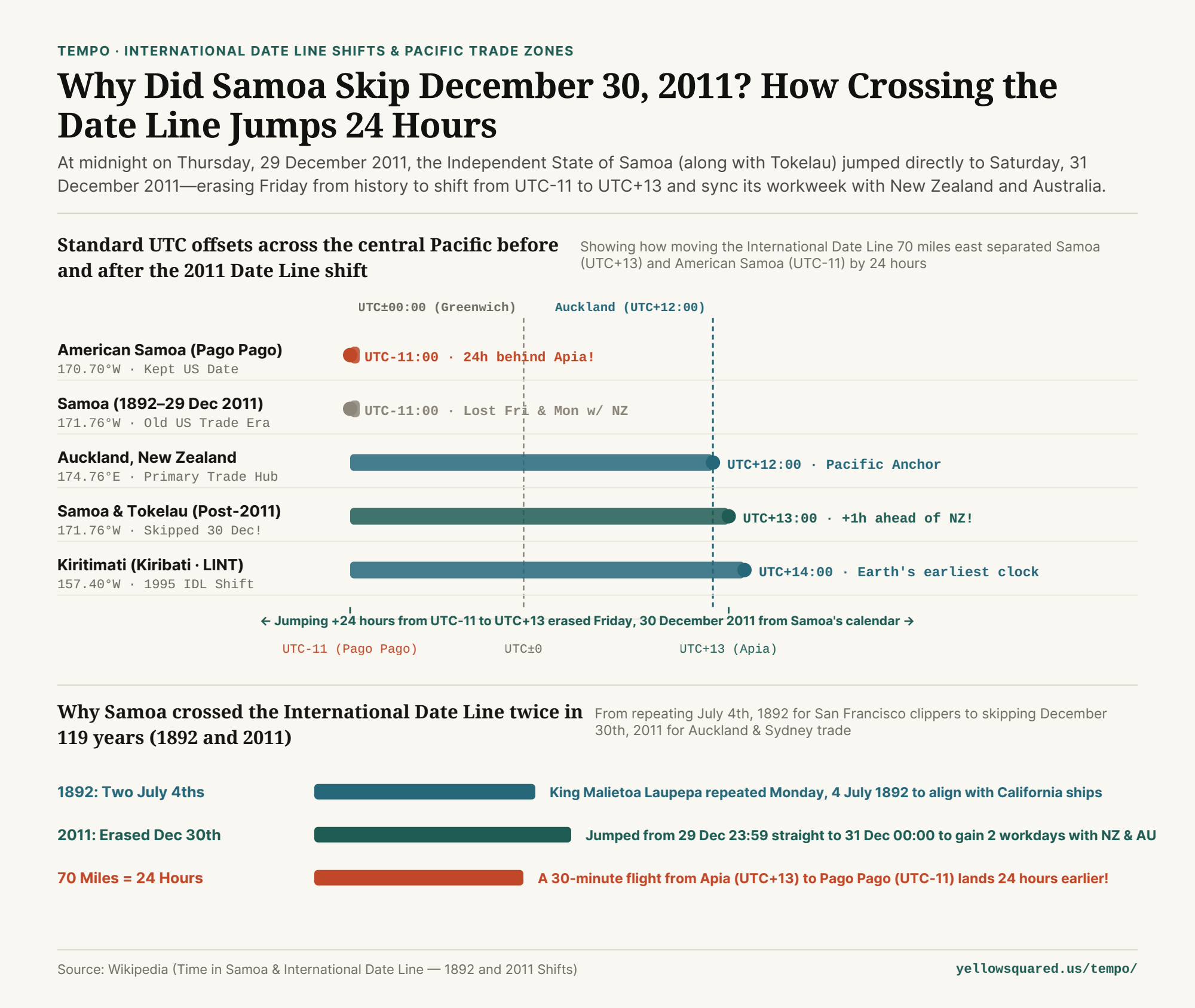
If you pull up historical hotel ledgers, bank statements, or birth certificates from Apia, Samoa in late December 2011, you will encounter a calendar riddle: Thursday, 29 December 2011 is followed immediately by Saturday, 31 December 2011. Friday, December 30th simply does not exist. Nobody forgot to wind the clock. By act of Parliament, the Independent State of Samoa—followed alongside by the New Zealand territory of Tokelau—redrew the International Date Line (IDL), leaping 24 hours forward from UTC-11:00 to UTC+13:00 (UTC+14:00 during summer DST at the time).

Chart showing Samoa's 24-hour jump from UTC-11:00 to UTC+13:00 on 29-31 December 2011 compared against American Samoa (UTC-11), Auckland (UTC+12), and Kiritimati (UTC+14)
Figure 1: Standard UTC offsets across central Pacific jurisdictions before and after the December 2011 International Date Line shift. Reproducible dataset: why-did-samoa-skip-december-30-2011-international-date-line.csv.

1. From Two July 4ths (1892) to Zero December 30ths (2011)

Wait—why was Samoa on the American side of the International Date Line in the first place? As documented in the historical records of Time in Samoa and the International Date Line, early European navigators arriving from Asia originally placed the Samoan archipelago on the western (Asian) side of the dateline. In 1892, however, American steamship and copra merchants based in San Francisco persuaded King Malietoa Laupepa to switch Samoa to the American date (`3 hours` behind California). To move backward a calendar day in 1892, Samoa celebrated Monday, 4 July 1892 twice in a row.

By the early 21st century, economic gravity had shifted completely. Samoa's dominant trading partners, supply chains, and largest expatriate communities were in New Zealand (UTC+12:00 / UTC+13:00) and Australia (UTC+10:00 / UTC+11:00). Sitting at UTC-11:00 meant Apia was 21 to 23 hours behind Auckland and Sydney: when it was Friday afternoon in Samoa, New Zealand businesses were already closed for Saturday; when Auckland opened on Monday morning, Samoa was still observing Sunday. Out of a 5-day Monday–Friday workweek, Samoa and New Zealand shared only 3 working days.

"By jumping 24 hours across the International Date Line at midnight on 29 December 2011, Samoa traded a 23-hour lag behind Auckland for a 1-hour lead—instantly gaining two full shared business days every week."

2. The 70-Mile Time-Travel Flight: Apia (UTC+13) vs. Pago Pago (UTC-11)

Because neighboring American Samoa (`Pacific/Pago_Pago`, an unincorporated U.S. territory located just 70 miles / 113 km east of Upolu) remained on the American side of the International Date Line at UTC-11:00, the 2011 shift routed the International Date Line straight through the narrow ocean channel between the two Samoas:

  • Same Solar Noon, Different Calendar Day: Apia (`171.76°W`) and Pago Pago (`170.70°W`) sit just 1.06° of longitude apart—a true solar time difference of only 4 minutes and 14 seconds. Yet their wall clocks sit exactly 24 hours apart (`UTC+13:00` vs. `UTC-11:00`).
  • Celebrating Your Birthday Twice: You can celebrate your birthday or New Year's Eve at midnight in Apia, board a 30-minute turboprop flight east to Pago Pago, and land 23 hours and 30 minutes earlier to celebrate the exact same calendar date all over again.
  • Tokelau's Simultaneous Shift: Because the New Zealand territory of Tokelau (`Pacific/Fakaofo`, `171.2°W`) relies on Apia as its primary shipping and administrative gateway, Tokelau skipped 30 December 2011 alongside Samoa, shifting from `UTC-11:00` to `UTC+13:00`.

3. Central Pacific International Date Line Comparison Table

Compare UTC offsets, Auckland time differences, and weekly shared business days across all five central Pacific jurisdictions below (available in why-did-samoa-skip-december-30-2011-international-date-line.csv):

Pacific Jurisdiction Reference City Standard Offset Gap vs Auckland (NZST) Shared Workdays w/ NZ Date Line History
American Samoa (US) Pago Pago (170.70°W) SST (UTC-11:00) -23 hours behind 3.0 days / week East of IDL (US Date)
Samoa (1892–2011) Apia (Pre-Shift) UTC-11:00 -23 hours behind 3.0 days / week Repeated 4 July 1892
Samoa (Post-2011) Apia (171.76°W) WST (UTC+13:00) +1 hour ahead! 5.0 days / week! Skipped 30 Dec 2011!
Tokelau (NZ) Fakaofo (171.20°W) TKT (UTC+13:00) +1 hour ahead 5.0 days / week Skipped 30 Dec 2011
Kiritimati (Kiribati) London (157.40°W) LINT (UTC+14:00) +2 hours ahead 5.0 days / week Skipped 31 Dec 1994

4. Compare Cross-Dateline Working Windows in Tempo

Note that Samoa permanently abolished seasonal Daylight Saving Time in 2021, locking `Pacific/Apia` to `UTC+13:00` year-round—matching New Zealand Daylight Time (`NZDT, UTC+13:00`) in summer and sitting 1 hour ahead of New Zealand Standard Time (`NZST, UTC+12:00`) in winter. To coordinate calls across the International Date Line without getting tripped up by a +1 or -1 calendar-day wrap, Open Tempo in your browser.

Verified Primary Sources

  1. Wikipedia — Time in Samoa (1892 July 4th Duplication, 29–31 December 2011 IDL Shift & 2021 Permanent UTC+13) (Retrieved 2026-10-31).
  2. Wikipedia — International Date Line: Samoan Islands, Tokelau, and 1995 Kiribati Realignments (Retrieved 2026-10-31).

044 / 56

Why Does Lord Howe Island Have a 30-Minute Daylight Saving Shift?

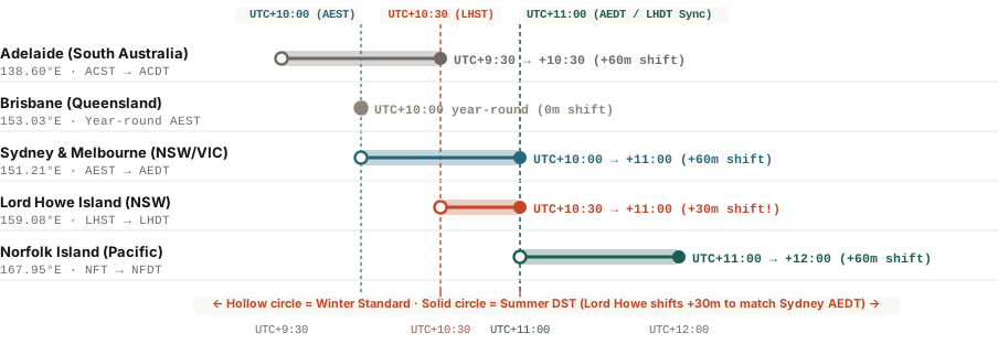
Located 600 km east of mainland Australia at 159.08°E, New South Wales's Lord Howe Island observes UTC+10:30 (LHST) in winter so solar noon aligns with the sun—then advances clocks by just 30 minutes to UTC+11:00 (LHDT) in summer to match Sydney.

Ask almost any software engineer how Daylight Saving Time works and you will hear the same universal rule: in spring, clocks jump forward by 60 minutes (`+3,600 seconds`); in autumn, they fall back by 60 minutes. Across North America, Europe, New Zealand, and mainland Australia, every single DST-observing jurisdiction shifts its clocks by exactly one full hour.

Every jurisdiction, that is, except one tiny crescent of volcanic basalt in the Tasman Sea. On Lord Howe Island—a UNESCO World Heritage island (`159.08°E`) with roughly 400 permanent residents located 600 kilometers (370 miles) east of Port Macquarie, New South Wales—clocks spring forward on the first Sunday in October by exactly 30 minutes, moving from Lord Howe Standard Time (`LHST, UTC+10:30`) to Lord Howe Daylight Time (`LHDT, UTC+11:00`). Understanding why `Australia/Lord_Howe` has the world's only half-hour Daylight Saving shift reveals a clever compromise between solar geography and mainland commerce.

Comparison of winter standard and summer daylight saving UTC offsets across Adelaide, Brisbane, Sydney, Lord Howe Island, and Norfolk Island
Figure 1: Winter Standard (hollow circles) versus Summer Daylight Saving (solid circles) UTC offsets across five Australian and Pacific time zones. Download coordinate dataset: why-does-lord-howe-island-have-a-30-minute-daylight-saving-shift.csv.

The 159.08°E Solar Dilemma: 36 Minutes Ahead of Sydney

Although Lord Howe Island is politically and administratively part of the state of New South Wales (governed from Sydney), its physical longitude in the Tasman Sea creates a 36-minute solar gap:

  • Mainland New South Wales (`150.0°E` Reference Meridian): Sydney (`151.21°E`) sits almost directly on the `150°E` meridian that defines Australian Eastern Standard Time (`AEST, UTC+10:00`).
  • Lord Howe Island (`159.08°E` Local Longitude): Because Earth rotates `1°` every 4 minutes, sitting `9.08°` east of `150°E` means sunrise, solar noon, and sunset arrive on Lord Howe Island 36 minutes and 19 seconds earlier than on the `150°E` meridian—and 31.5 minutes earlier than in Sydney.

If Lord Howe Island stayed on mainland `UTC+10:00` during winter, winter sunset in June would fall around 4:42 PM, plunging the island into darkness well before the workday ended. Conversely, when New South Wales introduced summer Daylight Saving Time (`AEDT, UTC+11:00`), if Lord Howe Island had started at `UTC+10:30` and added a full 60 minutes in summer (`UTC+11:30`), island businesses, Qantas flights from Sydney Airport, and NSW government offices would have remained out of sync by 30 minutes all year long.

A 30-minute Daylight Saving shift solves both problems at once: winter clocks follow the island's sun (`UTC+10:30`), while summer clocks lock directly onto Sydney (`UTC+11:00`).

How the 1981 Half-Hour Compromise Works (and Why It Breaks Code)

Codified under New South Wales's Standard Time Act 1987 (continuing the arrangement introduced in 1981), `Australia/Lord_Howe` operates on a seamless two-part cycle:

  1. Southern Winter (First Sunday in April → First Sunday in October): At `2:00 AM LHDT`, clocks turn back 30 minutes to `1:30 AM LHST` (`UTC+10:30`), matching the island's natural `157.5°E` half-hour solar meridian (`10.5 × 15° = 157.5°E`, within `1.58°` of the island).
  2. Southern Summer (First Sunday in October → First Sunday in April): At `2:00 AM LHST`, clocks advance 30 minutes to `2:30 AM LHDT` (`UTC+11:00`). Because Sydney advances 60 minutes from `UTC+10:00` to `UTC+11:00` on the exact same morning, Lord Howe Island and Sydney share the exact same clock (`UTC+11:00`) for all six months of the peak summer tourism season.
  3. The Software Engineering Lesson: In the IANA Time Zone Database (`tzdb`), `Australia/Lord_Howe` is the canonical test case for catching hardcoded `if (is_dst) offset += 3600;` bugs. Always compute UTC offset transitions by querying the zone's exact `tzdb` transition rules (`+1,800 seconds` for Lord Howe Island) rather than assuming `DST == 1 hour`.

Lord Howe is a useful test for time software because its daylight-saving change is 30 minutes, not the usual hour. A clock rule should use the time-zone database rather than adding 3,600 seconds.

When testing international scheduling apps or coordinating flights between Sydney, Brisbane, Adelaide, and the Tasman Sea, you can Open Tempo in your browser to inspect live `Australia/Lord_Howe` transitions alongside any global time zone.

045 / 56

Why Does Alaska Have Only One Mainland Time Zone?

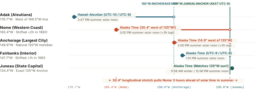
On October 30, 1983, Alaska collapsed four separate time zones onto the 135°W Juneau meridian (AKST, UTC-9 / AKDT, UTC-8) to synchronize state commerce—pulling Anchorage 2 hours and Nome 3 hours ahead of summer solar time.

Superimpose a map of Alaska over the contiguous United States and the scale is staggering: from the southeastern Panhandle at Hyder (`130.0°W`) to Attu Island at the western tip of the Aleutian chain (`172.9°E`), Alaska spans nearly 58 degrees of longitude—roughly the same east-to-west width as the distance from Savannah, Georgia, to San Francisco, California. By standard 15-degree astronomical geometry, Alaska is wide enough to require four separate time zones.

In fact, until October 30, 1983, Alaska did have four time zones. Today, however, 99% of the state's population—from Ketchikan and Juneau in the southeast to Anchorage, Fairbanks, Utqiagvik, and Nome on the Bering Strait—shares a single clock: Alaska Standard Time (`AKST, UTC-9` in winter and `AKDT, UTC-8` in summer). Understanding why Alaska abolished three of its time zones in 1983 explains why summer solar noon in western Alaska does not arrive until 3:02 PM in the afternoon.

Longitudinal alignment of Alaska cities from Adak and Nome to Anchorage and Juneau relative to the 135 degrees West AKST meridian
Figure 1: West-to-East longitudinal alignment of Adak, Nome, Anchorage, Fairbanks, and Juneau relative to the `135.0°W` Alaska Time reference meridian. Download coordinate dataset: why-does-alaska-have-one-mainland-time-zone-solar-lag.csv.

Before October 1983: When Juneau Was Two Hours Ahead of Anchorage

Prior to autumn 1983, conducting business or state government across Alaska was a logistical nightmare. The state was carved into four federal zones from east to west:

  • Pacific Time (`UTC-8` / `UTC-7`): Observed in Juneau (the state capital), Ketchikan, and Sitka in the Southeast Panhandle.
  • Yukon Time (`UTC-9` / `UTC-8`): Observed in a narrow, sparsely populated strip around Yakutat (`139.7°W`).
  • Alaska-Hawaii Time (`UTC-10` / `UTC-9`): Observed in Anchorage (`149.9°W`) and Fairbanks (`147.7°W`)—which held nearly three-quarters of the state's residents and matched the natural `150°W` solar meridian.
  • Bering Time (`UTC-11` / `UTC-10`): Observed in Nome (`165.4°W`), Bethel, and the western Aleutians.

Because Juneau sat on Pacific Time while Anchorage and Fairbanks sat on Alaska-Hawaii Time, the state capital was two hours ahead of its largest city—and three hours ahead of Nome. Once you subtracted lunch hours, citizens in Anchorage had barely four hours a day to reach state agencies in Juneau by phone, and Anchorage businesses sat a punishing 5 hours behind New York and Washington, D.C.

Rather than moving the state capital out of Juneau, Alaska moved the clocks of Anchorage, Fairbanks, and Nome eastward to meet Juneau on the 135°W meridian.

How the 1983 Consolidation Created a 3-Hour Solar Lag in Nome

Following a formal petition from the Alaska Legislature and Governor Bill Sheffield, the U.S. Department of Transportation issued a historic ruling that took effect on October 30, 1983 (the autumn Daylight Saving transition day):

  1. 99% of Alaska Merged Onto `135°W` (`UTC-9`): Juneau stepped back one hour from Pacific Time (`UTC-8`) to `UTC-9`, while Anchorage and Fairbanks skipped their autumn "fall back" and shifted permanently forward from `UTC-10` to `UTC-9` (renamed Alaska Standard Time). Only the Aleutian Islands west of `169°30'W` (`America/Adak`) remained on `UTC-10 / UTC-9` (renamed Hawaii–Aleutian Time).
  2. Anchorage's 2-Hour Summer Solar Lag: Because Anchorage sits at `149.9°W` (the natural `UTC-10` meridian), adopting `UTC-9` in winter and `UTC-8` in summer puts Anchorage 2 full hours ahead of solar time from March to November (`2:00 PM` solar noon).
  3. Nome's 3-Hour Summer Solar Lag: In Nome (`165.41°W`), which shifted two full time zones eastward from Bering Time (`UTC-11`) to Alaska Time (`UTC-9`), summer Daylight Saving Time (`AKDT, UTC-8`) pushes true astronomical midday to 3:02 PM on the clock.

Metlakatla keeps Pacific Time after choosing not to join Alaska Time. Adak remains the western exception, using UTC−10.

When planning flights, expedition logistics, or remote calls across Seattle, Juneau, Anchorage, and Honolulu, you can Open Tempo in your browser to compare Alaska and Hawaii–Aleutian offsets across seasonal DST changes.

046 / 56

Why Does Japan Not Observe Daylight Saving Time?

Japan observes Japan Standard Time (JST, UTC+9 anchored to the 135°E Akashi meridian) year-round—having repealed its 1948–1951 Allied occupation Daylight Saving law in 1952 after longer evening light increased unpaid overtime and sleep loss.

Travelers arriving in Tokyo in June are often stunned when bright morning sunlight streams through their hotel curtains at 4:25 AM—and even earlier in eastern Hokkaido, where the midsummer sun rises at 3:44 AM. Meanwhile, on the longest day of the year, sunset in Tokyo arrives by 7:00 PM. To visitors from North America or Europe, Japan looks like the prime candidate on Earth for Daylight Saving Time.

Yet Japan keeps its national clock locked to Japan Standard Time (JST, UTC+9) 365 days a year. Even more surprisingly, Japan already ran a nationwide four-year experiment with Daylight Saving Time between 1948 and 1951—and disliked the results so intensely that Parliament abolished it the moment the country regained sovereignty in 1952.

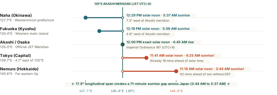
Longitudinal alignment of Japanese cities from Okinawa to Hokkaido relative to the 135 degrees East JST meridian
Figure 1: Longitudinal alignment and June solstice sunrise times across Japan relative to the `135.0°E` Akashi reference meridian (`UTC+9`). Download coordinate dataset: why-does-japan-not-observe-daylight-saving-time.csv.

The 1948–1951 Occupation Experiment (*Samātaimu*)

Following Imperial Ordinance No. 51 in 1886 (and Ordinance No. 167 in 1895), Japan standardized its national clock on the 135th meridian east passing through Akashi in Hyogo Prefecture (`UTC+9`). After World War II, the Supreme Commander for the Allied Powers (GHQ) pushed the Japanese Diet to pass the Summer Time Act (Law No. 29 of April 1948) to conserve coal and electricity during post-war reconstruction.

From May 1948 through September 1951, Japan advanced its clocks by one hour (`UTC+10`) every summer. Instead of saving energy or boosting leisure, the shift triggered immediate social backlash:

  • Unpaid Overtime Expansion: In post-war factories and offices, cultural norms discouraged leaving work while the sun was still up. Pushing sunset an hour later simply lengthened the workday without extra pay.
  • Sleep Deprivation in Humid Summers: Without residential air conditioning, advancing the clock forced families to try to sleep an hour earlier during the hottest, most humid part of the evening while farmers had to start morning chores in the dark.

By October 1951, a government public opinion poll showed 53% of Japanese citizens wanted Daylight Saving Time abolished (versus just 30% in favor). In April 1952—just days before the San Francisco Peace Treaty took effect ending the Allied occupation—the Diet repealed the Summer Time Act permanently.

Because Tokyo (139.7°E) already sits nearly 5 degrees east of Japan's 135°E reference meridian, its clock is naturally 19 minutes ahead of solar time year-round.

Why the US–Japan Time Difference Shifts Twice a Year

Ahead of the 2020 Tokyo Olympics, organizers briefly floated a proposal to advance Japanese clocks by two full hours (`UTC+11`) during summer so marathon runners could compete in cooler morning air. Japanese sleep researchers, software engineers, and the public overwhelmingly rejected the idea, preserving year-round `UTC+9`.

Because Japan never touches its clocks while the United States and Europe shift theirs twice a year, cross-Pacific meeting times move by 60 minutes every March and November: New York to Tokyo is 13 hours in summer (`EDT`) and 14 hours in winter (`EST`), while Seattle/Los Angeles to Tokyo is 16 hours in summer (`PDT`) and 17 hours in winter (`PST`). You can Open Tempo in your browser to check live US–Tokyo and Europe–Tokyo overlap windows across every seasonal transition.

047 / 56

Why Does the UK-Australia Time Difference Shift by Two Hours Each Year?

Because the United Kingdom (GMT/BST) and southeastern Australia (AEST/AEDT) sit in opposite hemispheres and shift Daylight Saving clocks in opposite directions, the London-to-Sydney time difference swings between 9, 10, and 11 hours across four annual transitions.

When distributed teams or families coordinate calls between London and New York, the time difference stays at 5 hours for almost the entire year (briefly shrinking to 4 hours during the week or two when US and UK Daylight Saving transitions don't quite line up). Between London and Sydney (or Melbourne), however, the clock math is far more dramatic: a meeting held at 8:00 AM London time lands at 5:00 PM in Sydney in July, 6:00 PM in mid-October, and 7:00 PM in December.

Because the United Kingdom sits in the Northern Hemisphere and Australia sits in the Southern Hemisphere, their summer Daylight Saving periods are completely inverted. Every autumn and spring, as one country springs forward by an hour and the other falls back by an hour, the total time difference swings by two full hours—from +9 hours to +11 hours—passing through two intermediate +10-hour shoulder windows along the way.

London to Sydney time difference shifting between 9, 10, and 11 hours across the year
Figure 1: Hours Sydney (`Australia/Sydney`) sits ahead of London (`Europe/London`) across all four annual clock regimes, compared with non-DST Brisbane (`Australia/Brisbane`). Download schedule dataset: uk-australia-time-difference-daylight-saving-shift.csv.

The Four Annual UK–Sydney Clock Windows

Tracking the two statutory transition rules—the UK's switch on the last Sunday of March and last Sunday of October (`Europe/London`) versus southeastern Australia's switch on the first Sunday of October and first Sunday of April (`Australia/Sydney`, `Australia/Melbourne`, `Australia/Canberra`, `Australia/Hobart`)—divides the year into four distinct scheduling seasons:

  1. Early April to Early October (+9 Hours — 26 Weeks): London observes British Summer Time (BST, UTC+1) while Sydney observes Australian Eastern Standard Time (AEST, UTC+10). Sydney is 9 hours ahead (`10 - 1 = 9`). This is the easiest half of the year for live collaboration: 8:00 AM to 9:30 AM in London overlaps neatly with 5:00 PM to 6:30 PM in Sydney.
  2. First Sunday in October to Last Sunday in October (+10 Hours — 3 to 4 Weeks): On the first Sunday in October, Sydney springs forward into Southern Hemisphere summer (AEDT, UTC+11), while London remains on BST (`UTC+1`) until the end of the month. With both cities simultaneously on Daylight Saving Time, Sydney sits 10 hours ahead (`11 - 1 = 10`).
  3. Last Sunday in October to Last Sunday in March (+11 Hours — 22 Weeks): On the last Sunday in October, London falls back to Greenwich Mean Time (GMT, UTC+0) while Sydney stays at `UTC+11`. The gap hits its annual maximum of 11 hours (`11 - 0 = 11`). An 8:00 AM London standup now pushes Sydney colleagues to 7:00 PM.
  4. Last Sunday in March to First Sunday in April (+10 Hours — 1 Week): London springs forward to BST (`UTC+1`) one week before Sydney falls back to AEST (`UTC+10`), creating a one-week 10-hour bridge around Easter.

Opposite-hemisphere Daylight Saving doesn't cancel out—it doubles the swing, turning two 1-hour clock changes into a 2-hour seasonal shift.

Why Brisbane and Perth Only Shift by One Hour

If your Australian counterparts live in Brisbane (Queensland) or Perth (Western Australia), the calendar math is much simpler. Because neither Queensland (`AEST, UTC+10` year-round) nor Western Australia (`AWST, UTC+8` year-round) observes Daylight Saving Time, their time difference with London only changes when the UK moves its clocks—shifting between +9 and +10 hours for Brisbane, and between +7 and +8 hours for Perth. To plan recurring calls across London, Sydney, Brisbane, and Perth without getting caught off guard by October or April transitions, you can Open Tempo in your browser to preview exact future date offsets automatically.

048 / 56

Why Is Spain in the Wrong Time Zone?

Although Madrid sits directly south of London along the Greenwich Prime Meridian (3.7°W), Spain shifted its national clock one hour ahead to Central European Time (UTC+1 / UTC+2) in March 1940—pushing summer sunsets past 10:00 PM in Galicia.

Glance at a map of Western Europe and trace the 0° Greenwich Prime Meridian straight down from London. The line passes through eastern Spain near Zaragoza, leaving Madrid (3.7°W) and almost the entire Iberian Peninsula firmly inside the natural Greenwich Mean Time (UTC+0) zone—and placing northwestern Galicia (8.7°W) nearly far enough west for UTC-1. Yet when you cross the land border from Portugal into Spain, you have to advance your watch by one full hour to Central European Time (CET, UTC+1 in winter and UTC+2 in summer).

Because Spain shares an official clock with Berlin, Warsaw, and Belgrade—cities located up to 2,000 miles to the east—the country lives in a permanent state of solar jet lag. Understanding how Spain ended up an hour (and in summer, two and a half hours) ahead of the sun explains everything from 10:15 PM Galician sunsets to why Spaniards eat lunch at 2:00 PM and dinner at 9:30 PM.

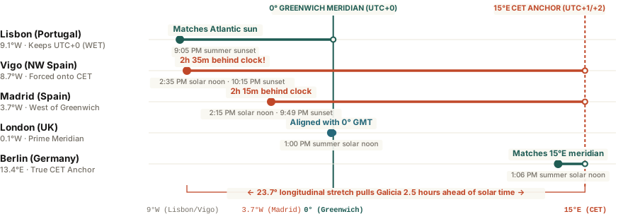
Spain longitudinal alignment west of Greenwich compared to Central European Time
Figure 1: Longitudinal position of Vigo, Lisbon, and Madrid west of the 0° Greenwich meridian versus the 15°E Central European Time anchor. Download raw coordinate data: why-does-spain-use-central-european-time.csv.

The March 1940 Wartime Clock Shift

From January 1, 1901, until early 1940, mainland Spain officially observed Greenwich Mean Time (UTC+0), matching its geographic longitude alongside the United Kingdom, Portugal, and France. On March 16, 1940, at 11:00 PM, Francisco Franco's government issued a decree advancing Spanish clocks by 60 minutes to midnight, aligning the nation with Central European Time.

Published in the official state bulletin (Boletín Oficial del Estado) as a temporary measure for the "convenience of synchronizing national time with other European countries," the shift matched the wartime clock expansions across occupied Western Europe. When World War II ended in 1945, Britain and Portugal returned to UTC+0, while Spain and France retained UTC+1 permanently—and compounded the offset in the 1970s by adding an extra hour of summer Daylight Saving Time (CEST, UTC+2).

Spaniards do not actually eat lunch later than the rest of Europe by the sun; they eat at 12:15 PM solar time, which their clock happens to label 2:15 PM.

How a 2.5-Hour Solar Lag Reshapes Daily Life

Because Earth rotates 15 degrees per hour (4 minutes per degree of longitude), anchoring Madrid (3.7°W) and Vigo (8.7°W) to the 30°E summer meridian (UTC+2) creates extraordinary daylight distortions:

  • 2:35 PM Solar Noon in Galicia: In western cities like Vigo, A Coruña, and Santiago de Compostela, true astronomical midday during summer does not arrive until 2:35 PM on the clock.
  • The Myth of the Late Spanish Meal: Tourists often marvel that Spanish restaurants do not open for lunch until 1:30 PM or 2:00 PM and serve dinner between 9:30 PM and 10:30 PM. In reality, when the clock reads 2:15 PM in Madrid, the sun is at its zenith (solar noon)—meaning Spaniards eat at the exact same biological sun angle as a Londoner eating lunch at 1:00 PM.
  • The Portugal Border Time Machine: Driving west from Badajoz, Spain, across the Caia River into Elvas, Portugal, rewinds your clock by 60 minutes even though both towns share the exact same solar meridian.

The Canary Islands are one hour behind mainland Spain. A 1900 decree established the mainland time rule, and the 1940 change moved Spain from Greenwich time to Central European Time.

When coordinating cross-border European travel or remote meetings across Madrid, Lisbon, and London, you can Open Tempo in your browser to compare live CET and WET workday overlaps without getting caught off guard by Iberian time shifts.