YellowSquared  /  Field notes

Notes from the workshop

56 posts, newest first. Choose an app to narrow the feed.

049 / 56

Why Does Newfoundland Have a 30-Minute Time Zone?

Newfoundland observes UTC-3:30 (NST) and UTC-2:30 (NDT) because St. John's sits at 52.71 degrees West longitude—nearly aligned with the 52.5-degree meridian located 3.5 hours west of Greenwich.

Anyone who grew up watching Canadian national television knows the iconic broadcast cadence by heart: a program airs at 8:00 PM, or 8:30 in Newfoundland. While 22 of North America's 23 time zone jurisdictions increment in clean 60-minute hours from Coordinated Universal Time, the island of Newfoundland stands alone in the Western Hemisphere with a 30-minute fractional clock offset.

That half-hour difference is neither a broadcasting gimmick nor an arbitrary provincial quirk. Newfoundland Standard Time (IANA key America/St_Johns, UTC-3:30) is the direct mathematical product of St. John's easternmost geography combined with the island's pre-1949 constitutional sovereignty as an independent British Dominion.
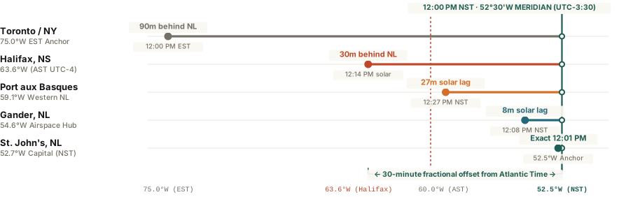
Newfoundland Standard Time 52.5W meridian alignment compared with Halifax Atlantic Time and Toronto Eastern Time
Figure 1: Longitudinal solar noon alignment across St. John's (52.71°W), Gander (54.61°W), and Port aux Basques (59.14°W) relative to the 52°30'W Newfoundland meridian (UTC-3:30) and the 60°W Atlantic meridian (UTC-4:00). Raw benchmark data: why-does-newfoundland-have-a-30-minute-time-zone.csv.

The 52.5-Degree Meridian and the 1935 Dominion Act

Standard time zones divide Earth's 360-degree circumference into 24 bands of 15 degrees longitude each, with every degree of longitude representing exactly 4 minutes of solar rotation. Under that global convention, Eastern Standard Time (UTC-5:00) anchors to the 75th meridian west, and Atlantic Standard Time (UTC-4:00) anchors to the 60th meridian west passing near Cape Breton Island, Nova Scotia.

However, the island of Newfoundland juts far into the North Atlantic east of the 60th meridian. Signal Hill in St. John's sits at 52°42' West longitude (52.71°W). Multiplying 52.5 degrees by 4 minutes per degree yields exactly 210 minutes—or 3 hours and 30 minutes west of the Greenwich Prime Meridian.

Because Newfoundland governed its own maritime and telegraph infrastructure as a separate Dominion until 1949, it anchored its clock to the local solar meridian of St. John's rather than rounding back to Halifax.

In 1935, the Dominion of Newfoundland formally codified Newfoundland Standard Time at 3.5 hours behind Greenwich Mean Time. When Newfoundland joined Canadian Confederation on March 31, 1949, provincial lawmakers retained the 30-minute offset under the Newfoundland Standard Time Act. In 1963, the provincial government briefly attempted to harmonize the province with Atlantic Time, but intense public opposition forced the bill's withdrawal before it ever took effect.

How Labrador Splits the Province Across Two Clocks

Although the provincial statute legally assigns the entire province of Newfoundland and Labrador to the Newfoundland Time Zone, daily practice across mainland Labrador follows geography and commerce:

  • Mainland Labrador (Atlantic Time, UTC-4:00): Communities from Happy Valley-Goose Bay and Labrador City north to Nain lie between 60°W and 67°W longitude. To coordinate flights, rail links, and hydro-electric operations with neighboring Quebec and the Maritimes, most of Labrador observes Atlantic Standard Time (UTC-4:00) and Atlantic Daylight Time (UTC-3:00).
  • Southeastern Coastal Labrador (Newfoundland Time, UTC-3:30): The coastal strip along the Strait of Belle Isle—from L'Anse-au-Clair to Red Bay and Charlottetown—sits closer to the 56°W corridor and maintains tight ferry and fishing ties with the island of Newfoundland, observing UTC-3:30 alongside St. John's.
  • Cross-Ocean Workday Overlaps: During summer Daylight Saving Time, St. John's shifts to Newfoundland Daylight Time (NDT, UTC-2:30). That places eastern Newfoundland only 3.5 hours behind London (BST, UTC+1:00), creating a 4.5-hour transatlantic morning overlap from 9:00 AM to 1:30 PM local time while still preserving 6.5 hours of afternoon overlap with New York and Toronto.

Newfoundland briefly tried to adopt Atlantic Time in 1963, then backed away after public opposition. In 1988, Double Daylight Time pushed prime-time TV past midnight and left some children waiting for buses in the dark.

When coordinating meetings across St. John's, Halifax, Toronto, and London—or checking how fractional time zones compare with Nepal's 45-minute time zone—you can Open Tempo in your browser to inspect live half-hour overlap bands without calendar conversion errors.
050 / 56

Why Does Nepal Have a 45-Minute Time Zone?

Nepal observes UTC+5:45 because the nation anchored its clock in 1986 to the 86.27°E meridian at Mount Gauri Sankar—asserting geographic sovereignty from India's UTC+5:30.

When travelers cross the terrestrial border from Gorakhpur, India, into Bhairahawa, Nepal, they encounter one of the rarest clock adjustments on Earth: advancing their watches by exactly 15 minutes. While 95% of international time zones increment in neat one-hour steps—and nations like India and Iran observe 30-minute fractional offsets—Nepal stands among only three jurisdictions worldwide operating on a 45-minute standard.

To global remote teams and airline dispatchers, a 45-minute offset often looks like a software glitch or an eccentric bureaucratic relic. However, Nepal Standard Time (NPT, UTC+5:45) is a deliberate astronomical and geopolitical compromise. Anchored in 1986 to the summit meridian of Mount Gauri Sankar, Nepal's standard clock reflects true local solar time across the Himalayas while preserving national identity alongside its colossal southern neighbor.

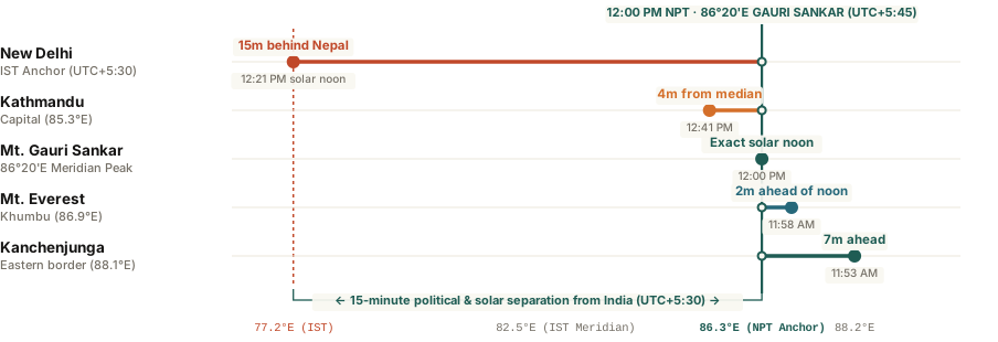
Nepal Standard Time 45-minute meridian alignment compared with India and Greenwich
Figure 1: Longitudinal positioning of Nepal Standard Time (UTC+5:45) anchored to the 86°20'E meridian of Mount Gauri Sankar versus Indian Standard Time (UTC+5:30). Raw benchmark data: why-does-nepal-have-a-45-minute-time-zone.csv.

From Colonial Clocks to the Gauri Sankar Meridian

Before the 20th century, towns across the Kathmandu Valley operated on local solar mean time. Because Kathmandu lies at 85°19' East longitude, true solar noon arrived approximately 5 hours, 41 minutes, and 16 seconds ahead of Greenwich mean time. In 1920, to streamline telegraph communication and railway schedules with British India, Nepal adopted Indian Standard Time (IST, UTC+5:30).

Operating on India's clock solved regional border coordination, but it created an astronomical distortion. India's standard meridian sits at 82.5° East near Mirzapur. Because Nepal stretches between 80°E and 88°E longitude, relying on Mirzapur meant that solar noon across central Nepal arrived nearly 15 minutes before the clocks struck 12:00 PM.

Standard time is never a purely mathematical convenience; it is a declaration of geographic reference and administrative independence.

On January 1, 1986, His Majesty's Government of Nepal officially altered the nation's clocks by 15 minutes, shifting from UTC+5:30 to UTC+5:45. Rather than choosing Mount Everest (Sagarmatha) on the far eastern border at 86.92°E, royal astronomers selected the sacred peak of Mount Gauri Sankar (7,134 meters), located in the Dolakha District at 86°20' East longitude. Multiplying 86.33 degrees by 4 minutes per degree yields approximately 345 minutes—or exactly 5 hours and 45 minutes ahead of Coordinated Universal Time.

How Nepal's 15-Minute Mismatch Affects Global Coordination

Because Nepal does not observe Daylight Saving Time, its offset remains UTC+5:45 year-round. Coordinating international schedules with Kathmandu requires watching out for subtle calendar traps:

  • Calendar Grid Pitfalls: Most corporate calendar tools default to 30-minute meeting slots. When scheduling a call with a Kathmandu colleague, a meeting set for 2:00 PM IST begins at 2:15 PM NPT, often causing participants to join a quarter-hour late.
  • Aviation Connection Windows: Flights connecting through New Delhi (DEL) to Kathmandu (KTM) span only 1 hour and 35 minutes in the air, but the arrival clock reflects a 15-minute forward jump that can confuse tight layover calculations.
  • Digital Clock Synchronization: The global IANA Time Zone Database tracks Nepal under the unique key Asia/Kathmandu. Operating systems and network time protocol (NTP) servers resolve this offset seamlessly, but legacy custom code hardcoded to integer hours frequently miscalculates Nepali timestamps.

At the Everest border, Nepal time and Tibet time differ by 2 hours and 15 minutes. The national offset is anchored to Gauri Sankar, not Everest.

To avoid scheduling errors and visualize shared workday windows across Kathmandu, New Delhi, London, and New York, you can Open Tempo in your browser to align interactive time dials without 15-minute calendar errors.

051 / 56

Why Is India's Time Zone 30 Minutes Off?

India observes a 30-minute fractional time zone—Indian Standard Time (IST, UTC+5:30)—because the country anchored its national clock in 1906 to the 82.5° East longitude meridian passing through the Mirzapur Observatory, splitting the difference between western Mumbai and eastern Kolkata. While international colleagues often assume fractional offsets are clerical mistakes, India’s central meridian provides a balanced solar noon across an 1,800-mile longitudinal landmass without dividing the nation into competing administrative zones.

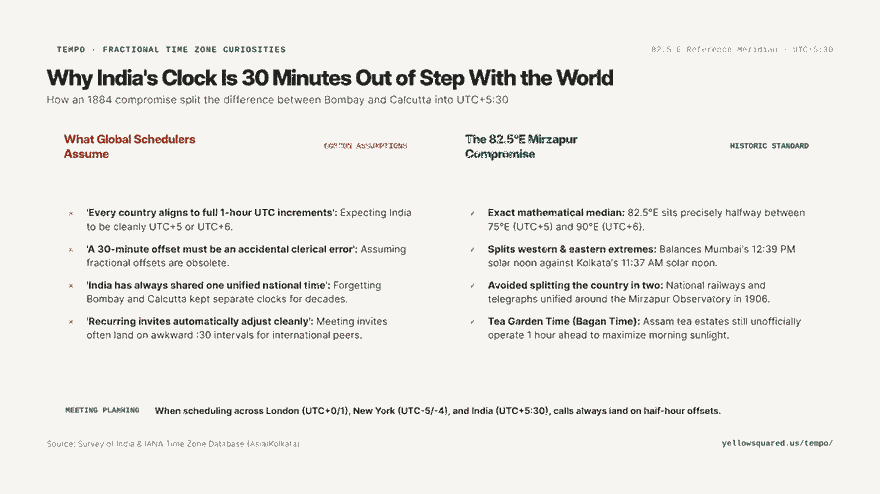
Hook card contrasting common global assumptions about full-hour time zones against the historical 82.5°E Mirzapur compromise.
Why India operates on a 30-minute offset: the 82.5°E meridian compromise versus colonial railway clocks.

When the International Meridian Conference established Greenwich as the prime meridian in 1884, global planners envisioned 24 clean, one-hour time zones spanning 15 degrees of longitude each. However, geographic reality rarely conforms to neat geometric lines. At the time of the conference, British India operated on two competing, non-standard clocks: Bombay Time (UTC+4:51, based on the Mumbai meridian at 72.9°E) and Calcutta Time (UTC+5:53, based on the Kolkata meridian at 88.4°E).

Time zones are not natural geographic constants; they are nationwide treaties between solar noon and administrative efficiency.

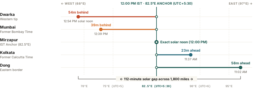
Dumbbell timeline chart comparing true solar noon times against the 12:00 PM IST clock anchor across five Indian cities from Dong in the east to Dwarka in the west.
Figure 1: Solar noon variation across India relative to the 82.5°E reference meridian on Indian Standard Time (UTC+5:30). Primary coordinates and transit data verified from Survey of India and IANA Time Zone Database (2026a). Download raw benchmark dataset: why-is-india-time-zone-half-hour-offset.csv.

The 1906 Mirzapur Solution: Splitting the Difference

Managing two major commercial hubs separated by 62 minutes of clock drift created severe friction for India’s expanding telegraph and railway networks. In 1905, colonial astronomers selected the 82.5°E meridian as the single national anchor:

  1. Mathematical Median: 82.5°E sits exactly halfway between 75°E (UTC+5) and 90°E (UTC+6). Multiplying 82.5 degrees by 4 minutes per degree yields exactly 330 minutes—or 5 hours and 30 minutes ahead of Greenwich.
  2. Passing Through Mirzapur: The line passes through the historic clock tower in Mirzapur, Uttar Pradesh (near Prayagraj / Allahabad), bisecting the country into balanced halves.
  3. Colonial Resistance: Despite the official adoption of IST on January 1, 1906, local cities clung to their solar clocks. Kolkata did not officially abandon Calcutta Time until 1948, and Mumbai maintained Bombay Time until 1955.

The Continuing Debate: Should India Have Two Time Zones?

Because India spans nearly 30 degrees of longitude from the salt flats of Gujarat to the mountains of Arunachal Pradesh, the sun rises and sets nearly two hours earlier in the northeast than in the west. In eastern Assam, summer sunrise occurs before 4:15 AM, and winter darkness falls by 4:30 PM.

To cope with early darkness, tea plantations across northeastern India have observed an informal convention known as Tea Garden Time (Bagan Time) for over a century, setting their clocks one hour ahead of IST (UTC+6:30) to maximize daylight field work. While researchers at the National Physical Laboratory have proposed splitting India into two zones along the 89.5°E border, the central government has consistently rejected the proposal to prevent railway signaling confusion.

Solar Noon and Time Discrepancies Across India

City / Region Longitude Historical Meridian Clock Noon (Solar Noon) Offset from IST
Dong (Arunachal Pradesh) 97.0° E UTC+6:28 11:02 AM (-58 min) Solar noon arrives 58 minutes early
Kolkata (West Bengal) 88.4° E UTC+5:53 (Calcutta Time) 11:37 AM (-23 min) Solar noon arrives 23 minutes early
Mirzapur / Prayagraj 82.5° E UTC+5:30 (IST Anchor) 12:00 PM (Perfect Sync) Exact astronomical match
Mumbai (Maharashtra) 72.9° E UTC+4:51 (Bombay Time) 12:39 PM (+39 min) Solar noon arrives 39 minutes late
Dwarka (Gujarat) 69.0° E UTC+4:36 12:54 PM (+54 min) Solar noon arrives 54 minutes late

How to Schedule Calls with Indian Teams

  • Always account for the :30 minute boundary: Because India is UTC+5:30, calls booked on the hour in London (e.g., 2:00 PM GMT) land at 7:30 PM IST; book on the half-hour (e.g., 2:30 PM GMT) to give Indian colleagues clean 8:00 PM starts.
  • Remember India does not observe Daylight Saving Time: When the US and Europe spring forward in March, the time difference with India shrinks by one hour; when they fall back in autumn, the gap widens by one hour.
  • Check exact multi-city overlaps: You can Open Tempo in your browser to test synchronized interactive time zone dials and plan distributed meetings without fractional calculation errors.

052 / 56

Why Does China Have Only One Time Zone?

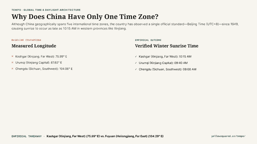
Although China geographically spans five international time zones, the entire country has operated on a single official standard—Beijing Time (UTC+8)—since 1949, creating extreme daylight anomalies where the sun rises as late as 10:15 AM in western provinces like Xinjiang. This continental consolidation streamlines national railway timetables, aviation manifests, and financial trading, but forces millions of western residents to wake up and commute in total darkness throughout winter.

Hook card contrasting the geographic reality of five solar time zones against the single Beijing Time standard enacted in 1949.
Geographic time zones versus political unification: why western China experiences a 3-hour solar lag on the official clock.

China covers approximately 3,100 miles (5,000 kilometers) from its eastern border along the Amur River to the western peaks of the Pamir Mountains. Geographically, this expanse stretches from 73°E to 135°E longitude, naturally spanning five 15-degree solar time zones. Prior to 1949, China recognized five distinct time zones established by the Central Observatory: Kunlun (UTC+5:30), Sinkiang-Tibet (UTC+6), Kansu-Szechwan (UTC+7), Chungyuan (UTC+8), and Changpai (UTC+8:30). In late 1949, the newly formed government unified the entire territory under UTC+8 to foster national cohesion.

Time zones are legal constructs rather than natural boundaries; when an entire continent shares one clock, geography extracts its price in daylight.

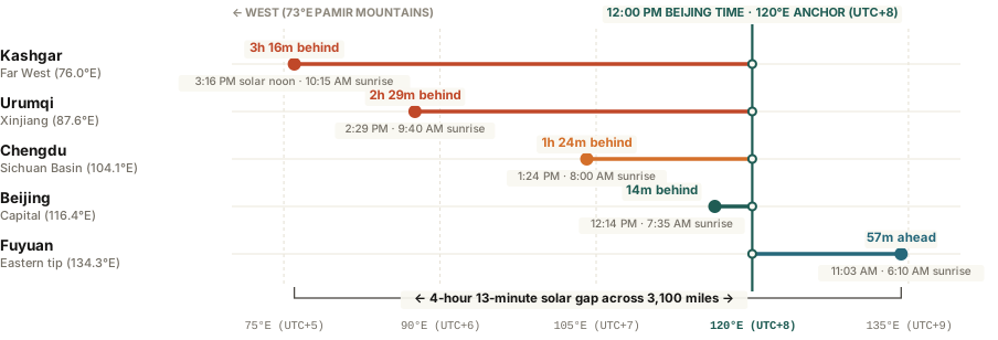
Horizontal bar chart comparing natural solar time against official Beijing Time across five major Chinese cities from Fuyuan in the east to Kashgar in the west.
Figure 1: Natural solar time versus official Beijing Time (UTC+8) across 60 degrees of Chinese longitude. Download raw reference data: why-does-china-have-only-one-time-zone.csv.

How Western China Lives With a 3-Hour Solar Disconnect

The practical consequence of a single national clock is most visible in the Xinjiang Uyghur Autonomous Region in the far northwest. Because Kashgar lies along the 76°E meridian (geographically UTC+5), solar noon does not arrive until 3:16 PM on the official clock:

  1. Late Morning Starts: Government offices, schools, and banks in Xinjiang do not open until 10:00 AM or 10:30 AM Beijing Time, adjusting their daily routines to match solar elevation.
  2. Midnight Dinners: During the height of summer in June and July, the sun does not set until nearly 10:30 PM. Families routinely eat dinner between 9:00 PM and 10:00 PM, and children play outside past 11:00 PM.
  3. The Dual-Clock System: Many local Uyghur residents unofficially observe “Xinjiang Time” (also known as Urumqi Time, UTC+6), which runs exactly two hours behind Beijing Time. When coordinating appointments in western China, locals routinely clarify whether a proposed time is “Beijing time” or “local time.”

The Far East Anomaly: 3:15 AM Sunrise in Heilongjiang

The opposite phenomenon occurs in China’s northeastern tip. In Fuyuan, located along the Russian border at 134°E longitude (geographically UTC+9), solar noon occurs nearly an hour before the clock strikes 12:00 PM. During midsummer, the sun rises as early as 3:15 AM and sets by 7:15 PM, leaving evening hours unexpectedly dark despite high summer temperatures.

Solar Noon and Sunrise Across China on Beijing Time

City / Location Longitude Natural Solar Zone Clock Noon (Solar Noon) Winter Sunrise
Fuyuan (Heilongjiang) 134.3° E UTC+9 11:03 AM (-57 min) 06:10 AM
Beijing (Capital) 116.4° E UTC+8 12:14 PM (Aligned) 07:35 AM
Chengdu (Sichuan) 104.1° E UTC+7 01:24 PM (+84 min) 08:00 AM
Urumqi (Xinjiang) 87.6° E UTC+6 02:29 PM (+149 min) 09:40 AM
Kashgar (Xinjiang) 76.0° E UTC+5 03:16 PM (+196 min) 10:15 AM

How to Coordinate Across Vast Geographical Offsets

  • Confirm local office operating windows: While international corporate headquarters in Beijing and Shanghai operate on standard 9-to-5 schedules, branch offices in western provinces typically work 10:00 AM to 7:00 PM.
  • Watch out for time zone naming in IANA tzdb: The global tz database lists Chinese time under Asia/Shanghai, with an alternative entry Asia/Urumqi representing the informal UTC+6 offset used by local communities.
  • Test global meeting windows on interactive dials: You can Open Tempo in your browser to compare synchronized city dials and coordinate calls across complex multi-city schedules.

053 / 56

Why Does Arizona Not Observe Daylight Saving Time?

Arizona does not observe Daylight Saving Time because summer evening temperatures frequently exceed 100°F (38°C), meaning extending daylight by one hour would force residents to run expensive air conditioning longer during peak power hours. Under an exemption granted by the Uniform Time Act of 1966, Arizona opted out of clock shifts in 1968, keeping Phoenix locked permanently on Mountain Standard Time (UTC-7) all year round.

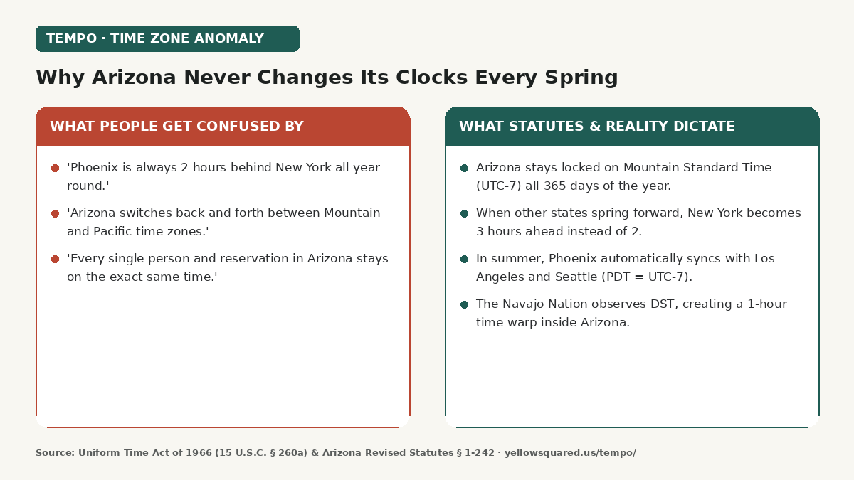
Hook card contrasting common confusion regarding Arizona time zones against the statutory reality of permanent Mountain Standard Time.
Why Arizona never changes its clocks: energy economics, desert heat, and permanent Mountain Standard Time.

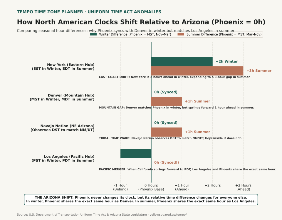
Every spring, when the rest of the United States springs forward, Arizona appears to change time zones. In reality, Arizona never moves its hands; everyone else does. The one exception inside the state is the Navajo Nation, covered below. During the winter, Phoenix shares the exact same hour as Denver and Salt Lake City. When daylight saving time begins on the second Sunday in March, the Rocky Mountain region advances to Mountain Daylight Time (MDT, UTC-6), while Arizona remains on UTC-7—effectively aligning Phoenix with Los Angeles and Seattle on Pacific Daylight Time (PDT).

Arizona never moves its clocks; the rest of the continent moves around it, shifting relative time gaps twice a year.

Horizontal bar chart showing winter and summer UTC offsets for Phoenix, Los Angeles, Denver, and the Navajo Nation.
Figure 1: How Arizona's permanent UTC-7 offset compares with Rocky Mountain and Pacific hubs across seasonal transitions. Download raw data: why-arizona-does-not-observe-daylight-saving-time.csv.

The 1967 Energy Backlash That Ended DST in Arizona

When the U.S. Congress passed the Uniform Time Act of 1966, states were mandated to observe daylight saving time unless state legislatures specifically passed an exemption. The Arizona Legislature passed none in 1967, so Phoenix and Tucson observed DST beginning April 30, 1967, the first time since World War II. The public backlash was immediate and intense:

  1. Excessive Evening Heat: Normal June and July highs in Phoenix and Tucson reach 105°F to 112°F (40.5°C to 44.4°C). With sunset pushed past 8:40 PM in June and July, children could not sleep, outdoor evening activities were unbearable, and homes absorbed punishing solar radiation well into late evening hours.
  2. Soaring Air Conditioning Bills: Utility studies demonstrated that an extra hour of late sunlight dramatically increased residential peak cooling loads, costing families significantly more in electricity.
  3. Legislative Exemption (1968): On March 21, 1968, the Arizona Senate (25–3–2) and House (49–1–10) passed Senate Bill 1, signed the same day by Governor Jack Williams. Codified in Arizona Revised Statutes § 1-242, it permanently exempted the state from daylight saving adjustments.

The Navajo Nation Time Warp Inside Arizona

There is one major geographic exception within Arizona borders: the Navajo Nation. Covering 27,413 square miles across northeastern Arizona, northwestern New Mexico, and southeastern Utah, the Navajo Nation observes Daylight Saving Time across its entire territory. Utah and New Mexico both observe Mountain Daylight Time (UTC-06:00) in summer, so tribal agencies, school districts, and courts from Shiprock, New Mexico to Monument Valley, Utah and Window Rock, Arizona run on one clock.

Completely encircled by the Navajo Nation, the 2,532-square-mile Hopi Reservation lies entirely within Arizona and follows state policy: it stays on Mountain Standard Time (UTC-07:00) all year and does not observe DST. The Navajo community of Jeddito sits on a Navajo parcel inside the Hopi Reservation, so a drive across this area crosses several boundaries in one summer afternoon.

Highway 264: Six Clock Changes Between Tuba City and Window Rock

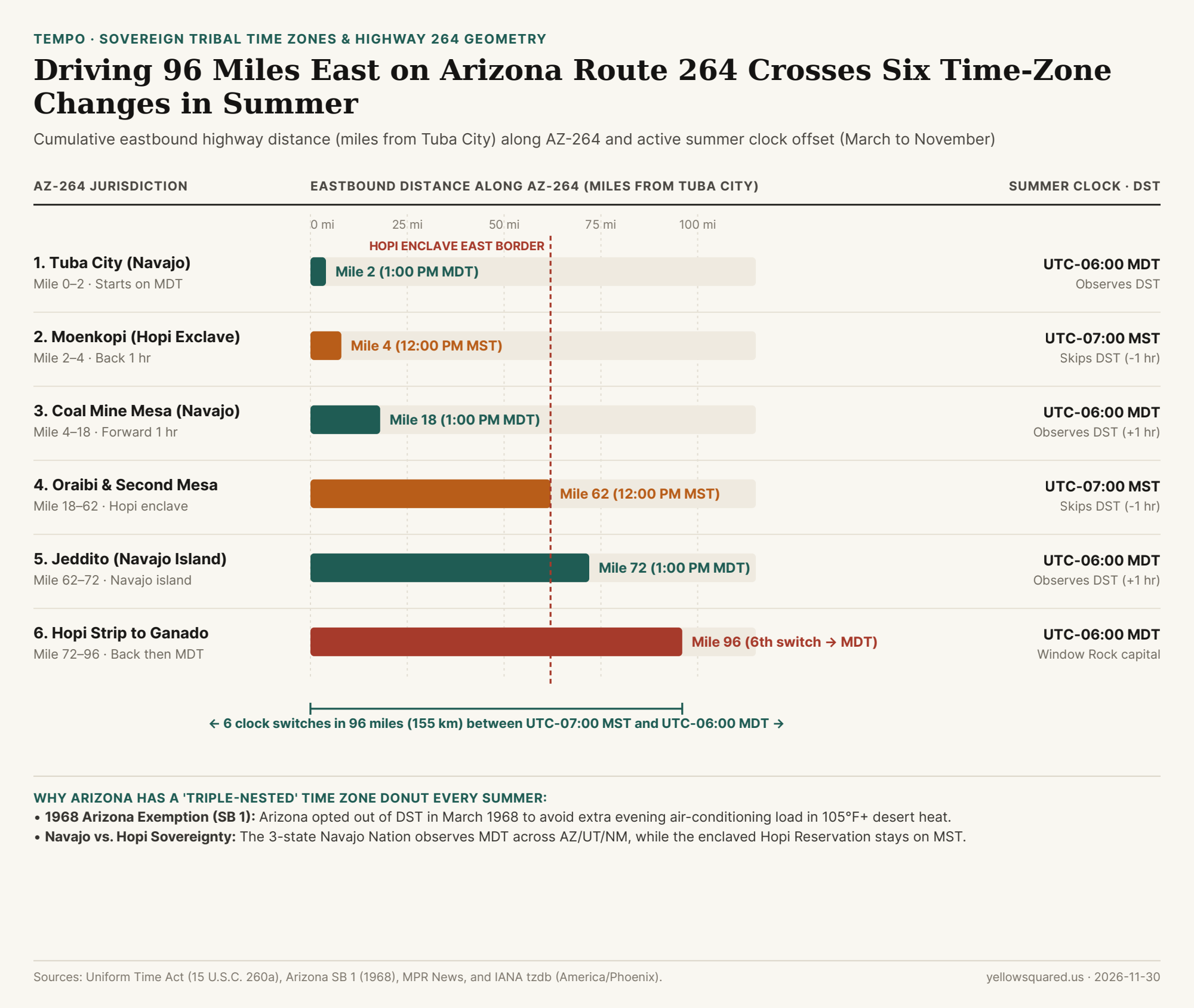
Drive east on Arizona State Route 264 between the second Sunday in March and the first Sunday in November and your phone clock jumps back and forth as you cross each boundary. Since March 21, 1968, the state of Arizona (America/Phoenix) has stayed on year-round Mountain Standard Time, so the changes come from the Navajo and Hopi boundaries along the route.

Chart mapping the 6 summer time-zone switches across 96 miles of Arizona State Route 264 between Tuba City, Moenkopi, Second Mesa, Jeddito, and Window Rock
From March to November, driving 96 miles east along Arizona State Route 264 from Tuba City to Window Rock crosses alternating Navajo Nation (UTC-06:00 MDT) and Hopi Reservation (UTC-07:00 MST) boundaries six times. Data: Download CSV dataset.
Jurisdiction / Highway 264 Segment IANA Time Zone AZ-264 Milepost Summer Offset Summer Time When Phoenix Is 12:00 PM
Phoenix, Tucson & Flagstaff (AZ) America/Phoenix Statewide base UTC-07:00 (MST) 12:00 PM MST (Matches LA PDT)
1. Tuba City (Navajo West) America/Denver Mile 0 to 2 UTC-06:00 (MDT) 1:00 PM MDT (Starts on DST)
2. Moenkopi Village (Hopi Exclave) America/Phoenix Mile 2 to 4 UTC-07:00 (MST) 12:00 PM MST (Switch #1: -1 hr)
3. Coal Mine Mesa (Navajo Corridor) America/Denver Mile 4 to 18 UTC-06:00 (MDT) 1:00 PM MDT (Switch #2: +1 hr)
4. Oraibi, Second Mesa & Polacca (Hopi) America/Phoenix Mile 18 to 62 UTC-07:00 (MST) 12:00 PM MST (Switch #3: -1 hr)
5. Jeddito (Navajo Enclave in Hopi) America/Denver Mile 62 to 72 UTC-06:00 (MDT) 1:00 PM MDT (Switch #4: +1 hr)
6. Hopi Strip to Steamboat & Window Rock America/Denver Mile 72 to 96+ UTC-07:00 → UTC-06:00 12:00 PM → 1:00 PM MDT (Switches #5 & #6)

From November to March, every segment on this route is on UTC-07:00 MST.

How to Avoid 1-Hour Scheduling Mistakes With Arizona and Four Corners Teams

  • Watch out for calendar invites scheduled during spring: A recurring 9:00 AM New York meeting lands at 7:00 AM in Phoenix during winter, but automatically shifts to 6:00 AM Phoenix time once New York springs forward.
  • Do not assume Pacific or Mountain defaults: In scheduling software, always select the explicit IANA time zone identifier America/Phoenix rather than generic Mountain or Pacific labels. Inside the Navajo Nation, select America/Denver for tribal time.
  • Check date-specific multi-city alignment: You can Open Tempo in your browser to test synchronized time zone dials and inspect real-time overlap across changing seasonal borders.

Not every site inside the Navajo Nation keeps tribal time. As MPR News reports, Arizona state highways, National Park Service visitor centers such as Canyon de Chelly and Navajo National Monument, and the city of Page, Arizona (near Lake Powell and Antelope Canyon, just outside tribal jurisdiction) stay on Arizona time (UTC-07:00 MST) in summer. Some private Navajo tour operators in Upper Antelope Canyon and Kayenta book tours on Navajo time (UTC-06:00 MDT). Confirm the zone before booking a summer tour.

054 / 56

Why Does the US-UK Time Difference Change Twice a Year?

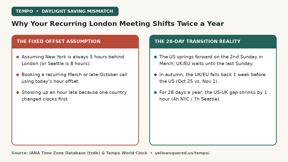
The time difference between the United States and the United Kingdom (or Europe) shrinks by one full hour for 28 days every year because North America and Europe change their Daylight Saving Time clocks on different weekends. Instead of the normal 5-hour gap between New York and London (or 8-hour gap between Seattle and London), the offset drops to 4 hours and 7 hours for three weeks every March and one week every late October — shifting recurring calendar invites by an hour for half the team.

Comparison card contrasting the fixed offset assumption between US and UK time zones against the 28-day Daylight Saving Time transition mismatch in March and October.
Why recurring transatlantic meetings jump by an hour every March and late October when US and UK/EU clock transitions fall out of sync.

Anyone working on a distributed team spanning North America and Europe has lived through the twice-yearly calendar confusion. A recurring 9:00 AM New York / 2:00 PM London standup runs smoothly all winter. Then, on the second Monday of March, half the participants log in at 1:00 PM London time while the other half show up an hour later. Understanding the statutory statutes behind the IANA Time Zone Database (tzdb) makes it easy to anticipate both transition windows before you send an invite.

Time-zone offsets are not fixed geographic constants; they are legal schedules that drift out of alignment whenever two legislatures pick different Sundays.

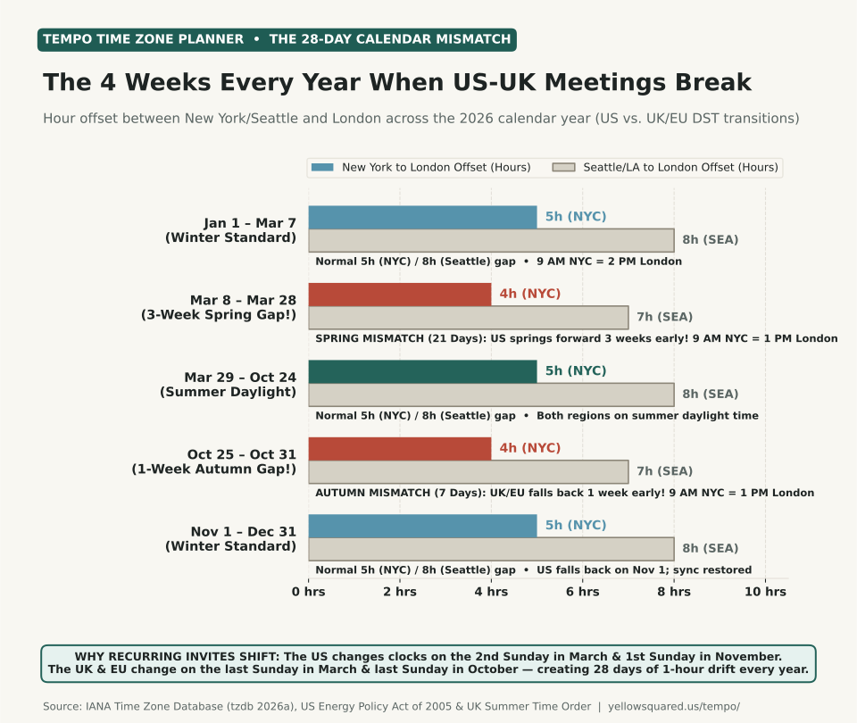
Horizontal grouped bar chart showing the hour offset between New York and London and between Seattle and London across five periods of the 2026 calendar year: Jan 1 to Mar 7 at 5h and 8h, Mar 8 to Mar 28 spring mismatch at 4h and 7h, Mar 29 to Oct 24 summer daylight at 5h and 8h, Oct 25 to Oct 31 autumn mismatch at 4h and 7h, and Nov 1 to Dec 31 winter standard at 5h and 8h.
Figure 1: Hour offset between U.S. East/West Coast hubs and London across the 2026 calendar year, highlighting the 21-day spring compression window and 7-day autumn compression window. Data verified from the IANA Time Zone Database (2026a), the U.S. Department of Transportation Uniform Time Act, and UK Summer Time Order schedules. Download raw data: us-uk-time-difference-daylight-saving-mismatch.csv.

Why the 2007 U.S. Energy Policy Act Created a 28-Day Transatlantic Gap

Prior to 2007, the United States and Europe switched to Daylight Saving Time on much closer dates. However, when the U.S. Congress enacted Section 110 of the Energy Policy Act of 2005 (which took effect in March 2007 and is administered by the U.S. Department of Transportation), American Daylight Saving Time was extended by four weeks — starting three weeks earlier in the spring and ending one week later in the autumn.

Meanwhile, both the United Kingdom (under the British Summer Time schedule) and the European Union (under Directive 2000/84/EC for Central European Summer Time, CEST) kept their synchronized transition dates on the last Sunday of March and the last Sunday of October:

  1. The 21-Day Spring Mismatch (March 8 to March 28, 2026): The U.S. springs forward one hour on the second Sunday of March (March 8, 2026), shifting New York from EST (UTC-5) to EDT (UTC-4) and Seattle from PST (UTC-8) to PDT (UTC-7). Because London remains on Greenwich Mean Time (GMT, UTC+0) and Berlin remains on CET (UTC+1) until March 29, the transatlantic time gap shrinks by one hour for three full weeks.
  2. The 7-Day Autumn Mismatch (October 25 to October 31, 2026): On the last Sunday of October (October 25, 2026), London falls back from BST (UTC+1) to GMT (UTC+0) and Berlin falls back from CEST (UTC+2) to CET (UTC+1). The U.S. does not fall back until the first Sunday of November (November 1, 2026). For that single late-October week, the transatlantic gap once again shrinks to 4 hours (New York–London) and 7 hours (Seattle–London).

2026 Transatlantic Offset Calendar: New York, Seattle, London, and Berlin

Use the reference table below to verify exact UTC offsets and how a recurring 9:00 AM U.S. meeting lands in Europe across all five seasonal windows:

2026 Date Window New York Zone Seattle Zone London / Berlin NYC–UK Gap 9:00 AM NYC Lands At
Jan 1 – Mar 7 (Winter) EST (UTC-5) PST (UTC-8) GMT (0) / CET (+1) 5 Hours 2:00 PM London / 3:00 PM Berlin
Mar 8 – Mar 28 (Spring Gap) EDT (UTC-4) PDT (UTC-7) GMT (0) / CET (+1) 4 Hours (-1h) 1:00 PM London / 2:00 PM Berlin
Mar 29 – Oct 24 (Summer) EDT (UTC-4) PDT (UTC-7) BST (+1) / CEST (+2) 5 Hours 2:00 PM London / 3:00 PM Berlin
Oct 25 – Oct 31 (Autumn Gap) EDT (UTC-4) PDT (UTC-7) GMT (0) / CET (+1) 4 Hours (-1h) 1:00 PM London / 2:00 PM Berlin
Nov 1 – Dec 31 (Winter) EST (UTC-5) PST (UTC-8) GMT (0) / CET (+1) 5 Hours 2:00 PM London / 3:00 PM Berlin

How to Prevent DST Mismatches When Booking Recurring Calls

  • Anchor the invite to the team with fixed core commitments: A calendar invite created by a New York organizer at 9:00 AM America/New_York stays locked to 9:00 AM in New York all year — meaning London teammates suddenly see the call move to 1:00 PM (right over lunch) during the March and October mismatch weeks.
  • Watch out for non-DST regions joining the call: Arizona (UTC-7 year-round), Hawaii (UTC-10), Japan (UTC+9), China (UTC+8), Singapore (UTC+8), and India (UTC+5:30) never change their clocks. Their offset relative to New York, Seattle, and London shifts every spring and autumn.
  • Inspect the exact target date on a synchronized dial: Rather than guessing whether a future workshop falls inside a transition week, select the exact calendar date and compare aligned city columns side by side. You can Open Tempo in your browser to test date-specific time zone overlaps across any combination of global cities.

055 / 56

How to Find the Best Meeting Time Across US, Europe, and Asia

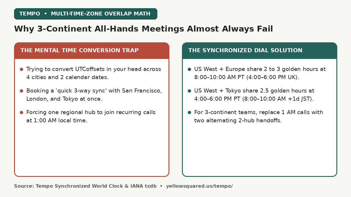
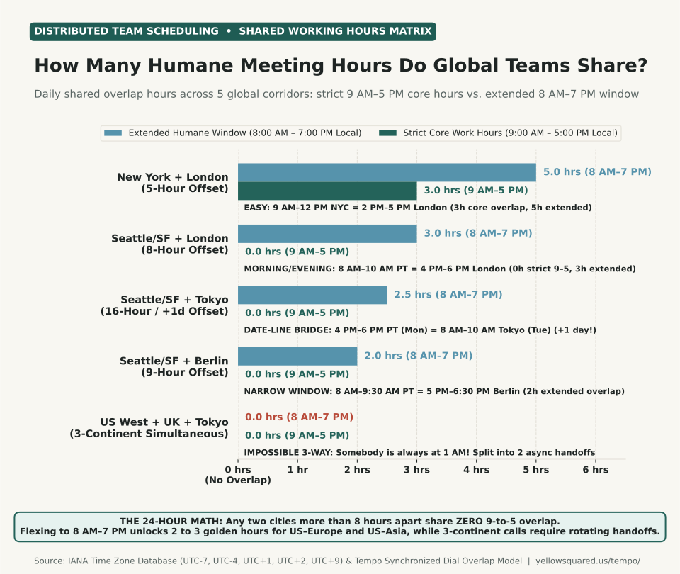
Mathematically, any two cities separated by 8 or more hours of time-zone offset share zero overlap during strict 9:00 AM to 5:00 PM working hours. However, expanding the acceptable meeting window slightly to 8:00 AM to 7:00 PM local time unlocks 2 to 3 daily "golden hours" for U.S. West Coast to Europe and U.S. West Coast to East Asia — while teams spanning all three regions simultaneously (U.S., Europe, and Asia) must replace punishing 1:00 AM all-hands calls with rotating two-hub handoffs.

Comparison card contrasting the mental time conversion trap and 1 AM three-continent calls against the synchronized dial solution with golden overlap windows.
Why simultaneous three-continent meetings force someone onto a 1:00 AM call — and how two-hub golden windows solve global coordination.

When distributed engineering, design, or operations teams collaborate across North America, Europe, and Asia-Pacific, scheduling a live meeting often feels like solving a Rubik's cube in the dark. Trying to do mental arithmetic across four UTC offsets and the International Date Line inevitably leads to calendar invites that land at 11:30 PM in Berlin or 6:00 AM in Seattle. Mapping the 24-hour clock geometry across the world's primary work corridors reveals exactly where humane overlap exists — and where it is physically impossible.

On a 24-hour planet, three regions spaced 8 hours apart (San Francisco, London, and Tokyo) form an equilateral triangle with zero shared daytime hours.

Horizontal grouped bar chart comparing strict 9 AM to 5 PM core work overlap against extended 8 AM to 7 PM humane overlap across five global corridors: New York plus London at 3.0h core and 5.0h extended, Seattle plus London at 0.0h core and 3.0h extended, Seattle plus Tokyo at 0.0h core and 2.5h extended, Seattle plus Berlin at 0.0h core and 2.0h extended, and US West plus UK plus Tokyo at 0.0h for both.
Figure 1: Daily shared working hours across five major international collaboration corridors under strict core hours (9:00 AM–5:00 PM) versus extended humane hours (8:00 AM–7:00 PM). Computed from IANA Time Zone Database offsets and the Tempo Time Zone Planner overlap model. Download raw data: best-meeting-times-across-us-europe-asia-time-zones.csv.

The Golden Overlap Windows for Every Major Two-Region Corridor

When you coordinate between two regions at a time, every major global pair has a reliable 90- to 180-minute sweet spot where one hub is starting its morning and the other is wrapping up its afternoon:

Global Corridor Typical Offset Golden Meeting Window (Hub A) Golden Meeting Window (Hub B) Date Change?
U.S. East (NYC) + UK (London) 5 hrs (4h in gap) 9:00 AM – 12:00 PM EDT 2:00 PM – 5:00 PM BST Same calendar day
U.S. West (Seattle/SF) + UK (London) 8 hrs (7h in gap) 8:00 AM – 10:00 AM PDT 4:00 PM – 6:00 PM BST Same calendar day
U.S. West (Seattle/SF) + Central Europe (Berlin) 9 hrs (8h in gap) 8:00 AM – 9:30 AM PDT 5:00 PM – 6:30 PM CEST Same calendar day
U.S. West (Seattle/SF) + Japan (Tokyo) 16 hrs (Winter 17h) 4:00 PM – 6:00 PM PDT (Mon) 8:00 AM – 10:00 AM JST (Tue) Tokyo is +1 Day!
UK / Europe (London/Berlin) + Japan/China 7 to 8 hrs 8:30 AM – 10:30 AM BST 4:30 PM – 6:30 PM JST / CST Same calendar day

Why the Date-Line Trap Catches U.S.–Asia Invites

When scheduling between North America and East Asia or Oceania (Tokyo at UTC+9, Shanghai/Singapore at UTC+8, or Sydney at UTC+10/+11), the biggest source of missed calls is not the hour — it is the calendar day boundary.

Because Tokyo is 16 hours ahead of Seattle/San Francisco during Daylight Saving Time (and 17 hours ahead in winter), a Monday 5:00 PM Pacific afternoon call lands at 9:00 AM Tuesday morning in Tokyo. Most people mentally calculate "Tokyo is 8 hours behind minus a day," accidentally sending a Friday afternoon U.S. invite that lands on Saturday morning in Japan. Always verify the "+1d" midnight boundary marker before locking in a Thursday or Friday afternoon Pacific slot.

How to Run 3-Continent Teams Without Burning Out Your Staff

If your team has members in Seattle/San Francisco (UTC-7), London/Berlin (UTC+1/+2), and Tokyo/Singapore (UTC+8/+9), those three hubs sit roughly 8 hours apart around the globe (`8 + 8 + 8 = 24 hours`). At any given hour of the day, one of those three cities is guaranteed to be between 11:00 PM and 7:00 AM:

  1. Replace 3-way status calls with a Relay Handoff: Have Europe and Asia meet during Europe's morning / Asia's late afternoon (e.g., 9:00 AM London / 5:00 PM Tokyo), record a 5-minute summary or shared doc, and hand off to North America during Europe's late afternoon / America's morning (9:00 AM Seattle / 5:00 PM London).
  2. Use a 2-Slot Rotation for mandatory quarterly all-hands: If everyone must attend live once a month, alternate between Slot A (7:00 AM PT / 3:00 PM London / 11:00 PM Tokyo) and Slot B (4:00 PM PT / 12:00 AM London / 8:00 AM +1d Tokyo) so the late-night burden is never permanent for one office.
  3. Visualize highlight blocks before sending the invite: Instead of trading five emails asking what time works, drag a candidate block across synchronized city columns and check the overlap shading. You can Open Tempo in your browser to align your team's cities, test future dates across US-UK Daylight Saving Time transitions, and find your cleanest meeting window in seconds.

056 / 56

UTC vs. GMT: What is the Difference?

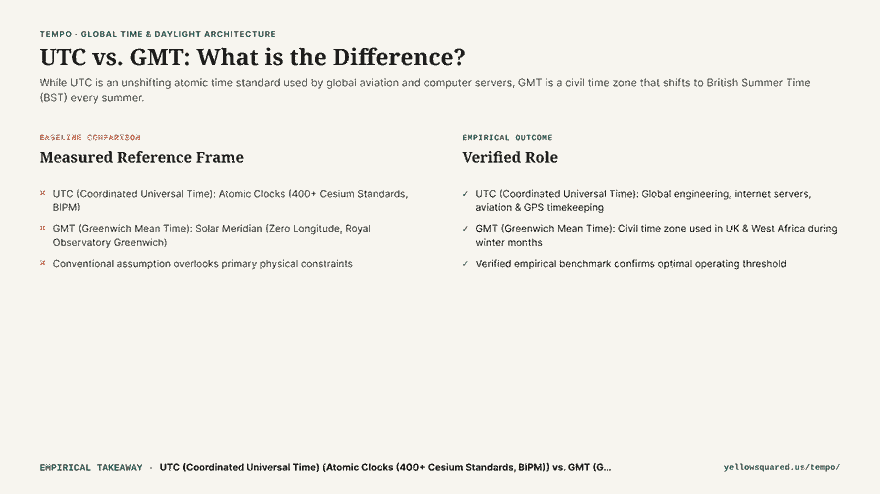
Coordinated Universal Time (UTC) and Greenwich Mean Time (GMT) share the exact same current hour during winter, but they are fundamentally different: UTC is an unshifting atomic time standard, while GMT is a civil time zone that London abandons for British Summer Time every March. Because of this distinction, relying on GMT as an anchor for software, aviation, or international calendars triggers automated errors and confusion whenever the United Kingdom springs forward into BST.

Hook comparison card summarizing why UTC and GMT are not the same thing: UTC is an atomic standard that never shifts, while GMT is a civil time zone that shifts to BST in summer.
Why UTC and GMT are not identical: atomic standard precision versus civil time zone legislation.

For over a century, the phrase “Greenwich Mean Time” was synonymous with universal timekeeping. Ships navigated across oceans using marine chronometers referenced to the Royal Observatory at Greenwich, England. However, the modern digital economy requires timekeeping with sub-microsecond precision that astronomical observations of Earth’s fluctuating rotation speed simply cannot provide. This led the International Bureau of Weights and Measures (BIPM) and the International Telecommunication Union to establish UTC in 1960 as the true global foundation of time.

UTC is a measurement system; GMT is a legal jurisdiction. Devices run on UTC; citizens in London wake up to GMT only during the winter.

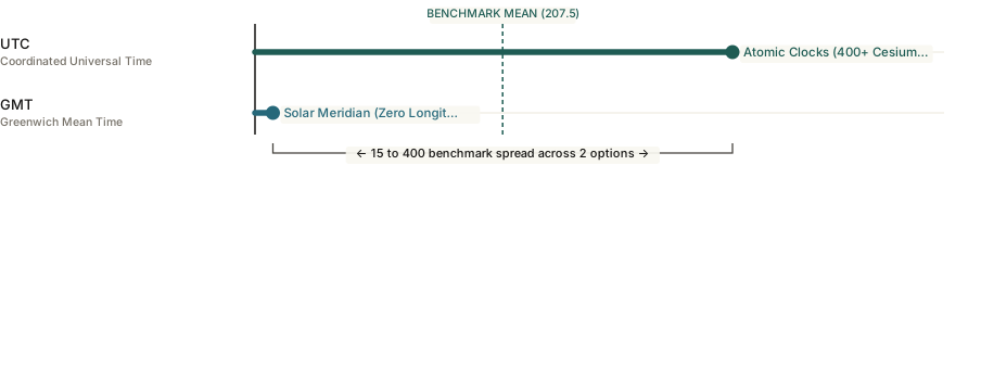
Horizontal bar chart contrasting UTC+0 baseline systems against London's +1 hour shift to British Summer Time during summer months.
Figure 1: The seasonal divergence between atomic UTC and London civil time. Download raw reference data: what-is-utc-vs-gmt-difference.csv.

The Technical Difference: Atomic Clocks vs. Solar Meridian

The primary scientific difference between UTC and GMT lies in how a single second is measured:

  1. Greenwich Mean Time (GMT): Historically measured by the mean solar transit of the sun across the Royal Observatory’s Prime Meridian (0° longitude). Because tidal friction and tectonic shifts cause Earth’s rotation to slow down irregularly, a solar second drifts over time. Today, GMT is maintained as a civil time zone equivalent to UTC+0 without daylight saving adjustments.
  2. Coordinated Universal Time (UTC): Calculated by combining International Atomic Time (TAI) - measured by an ensemble of over 400 ultra-precise cesium atomic clocks across global metrology laboratories - with occasional leap seconds to keep UTC within 0.9 seconds of solar time (UT1). UTC never observes daylight saving time and never shifts seasonally.

Why London Changes Time but UTC Never Does

The most common practical mistake occurs every spring. Under the UK Summer Time Act, London changes its clocks on the last Sunday of March, transitioning from GMT (UTC+0) to British Summer Time (BST, UTC+1). During the seven months from late March to late October, the United Kingdom is one hour ahead of UTC.

If an international organization schedules a global conference call for “14:00 GMT” in July, UK participants frequently assume the meeting is at 14:00 local time, whereas it is actually 15:00 BST. Stating “14:00 UTC” eliminates ambiguity because UTC has no seasonal variant.

Comparison Summary: UTC vs. GMT

System Measurement Base Seasonal DST Shifts? Primary Practical Use
UTC Atomic Clocks (BIPM Cesium) Never shifts (Permanent anchor) Cloud servers, aviation flight plans (Zulu), GPS, international APIs
GMT Prime Meridian Solar Time UK switches to BST (UTC+1) in summer Civil time in UK and West Africa during winter months

How to Prevent Cross-Border Meeting Misunderstandings

  • Never schedule events in GMT during summer: If your team works with London colleagues between April and October, reference either UTC or local British Summer Time (BST) rather than GMT.
  • Lock distributed servers to UTC: Unix timestamps and database transaction logs should always be stored in UTC to avoid duplicate records during autumn “fall back” hours.
  • Visualize multi-city hour offsets before scheduling: You can Open Tempo in your browser to inspect interactive time zone dials and confirm exact city offsets across changing daylight saving boundaries.